Downloads
Overview
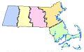
This layer represents the district boundaries of the Massachusetts Division of Fisheries and Wildlife . These districts are used by DFW and its parent agency, the Department of Fish and Game , for administrative purposes.
Two layers - polygon and arc feature classes - are stored in ArcSDE as DFWDISTRICTS_POLY and DFWDISTRICTS_ARC.
The polygon feature class was updated in August 2021 to be based on the Survey Towns Boundaries (previously based on the USGS-based town boundaries).
Production
The layer was developed by the Department of Fish and Game GIS Program by dissolving (combining) polygons from MassGIS' Municipalities layer. The arc layer was generated by MassGIS using ESRI'S ArcGIS 9.0 software.
Attributes
The polygon attribute table contains the following items:
| Item | Description |
|---|---|
| DISTRICT | DFW District Name |
| ACRES | Area of DFW District in acres |
The arc attribute table contains the following items:
| Item | Description |
|---|---|
| OUTLINE | Boundary type: 9 = DFW District boundary 1 = State outline 4 = Coastline |
Maintenance
The DFG GIS Program will provide any updates to MassGIS.
Updated in April 2022 to reflect recent edits to the Municipalities layers.