Downloads
Overview
These datalayers represent place names for geographic features, which may be used for map labels. They are grouped into three categories and stored in three geodatabase annotation feature classes (listed in parentheses):
- hydrographic features - lakes, ponds, streams, rivers, bays, harbors, channels that appear in the 1:25,000 Hydrography layer (GEONAMES_ANNO_HYDRO)
- civic features (place names) - city and town names, sections, villages (GEONAMES_ANNO_PLACES)
- hypsographic features - hills, mountains, points, beaches, islands (GEONAMES_ANNO_HYPSO)
The data originated from the U.S. Geological Survey’s Board on Geographic Names, U.S. Geological Survey, 19810501, U.S. Geographic Names Information System (GNIS) U.S. Geological Survey, Reston, VA. The point features were converted to Mass State Plane NAD83 meters coordinates and attributes were added.
Those features considered as hypsographic features or place names were then converted into annotation and added to older geonames annotation feature classes and modified for size and placement.
Hydrographic features were taken from the USGS’s National Hydrographic Dataset NHD FlowLine feature class. Hydrographic line features were labeled with their GNIS (Geographic Names Information System) FEATURE_NAME using the Maplex labeling engine which placed features along streams at defined intervals. These features were converted to annotation and added to the existing Hydrography annotation feature class and edited for placement and size. Lake and other water feature names were added from the NHD Waterbody feature class, converted to annotation, added to the existing Hydrography annotation feature class and edited for size and placement.
In the MassGIS Data Viewer all three geodatabase annotation feature classes are accessible from this Viewer menu choice:
CATEGORY: Physical Resources
SUBCATEGORY: Geographic Names
DATASET NAME: Geographic Names Additionally, the hydrography labels may be accessed with this Viewer menu choice: CATEGORY: Physical Resources
SUBCATEGORY: Hydrography (Water Features)
DATASET NAME: Hydrography - 25k USGS (Labels)
Displaying the data
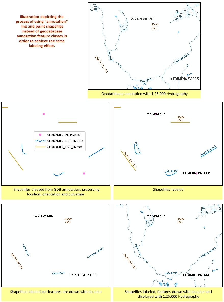
The colors and fonts of the annotation are properties of the feature classes and are normally preserved when displayed in software like ArcGIS. For GIS users who cannot work with geodatabase annotation, MassGIS has produced line and point shapefiles that contain the text string attributes of the annotation. The shapefiles may be added to a data/map view and labeled, but the features themselves would be set to display with no color and size. As an example, the hydrography "annotation" line shapefile would be labeled, and the features (the lines) displayed transparently, along with the 1:25,000 Hydrography layer. The following graphic provides an illustration:
MassGIS stores these layers as:
- GEONAMES_LINE_HYDRO
- GEONAMES_LINE_HYPSO
- GEONAMES_PT_HYPSO
- GEONAMES_PT_PLACES
Click on the image to view the illustration full size
Maintenance
The MassDEP GIS Group and MassGIS maintain the data. In March 2013 MassGIS replaced the data downloads to update a hydrographic feature (pond) name in Plymouth. The Medford Hillside label in PLACES was moved in August 2013. Removed the "Shaker Beach" Hypso feature off Orleans in October 2023 based on input from The Compact of Cape Cod Conservation Trusts.