Downloads
Overview
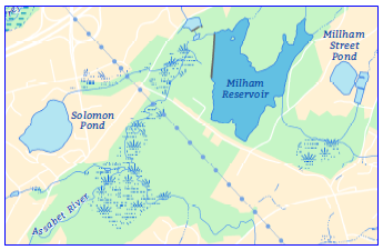
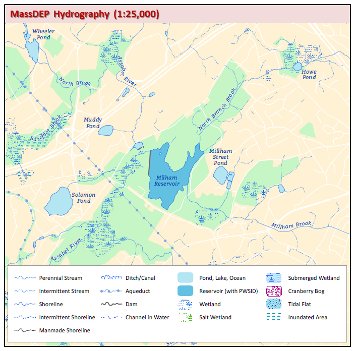
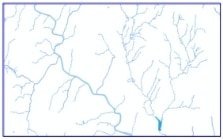
The MassDEP Hydrography layer is an enhanced version of the older U.S. Geological survey 1:25,000 Hydrography datalayer. It represents hydrographic (water-related) features, including surface water (lakes, ponds, and reservoirs), wetlands, bogs, flats, rivers, streams, and others (see below).
The layer is a hybrid of data based on USGS Digital Line Graphs (DLGs), scanned mylar separates obtained from the USGS, digitized hydrographic features from paper USGS 1:25,000 Topographic Quadrangle maps and data extracted from the MassDEP Wetlands datalayer. Areas within many surface water supply watersheds have been enhanced by using higher resolution streams and lakes from the MassDEP Wetlands datalayer, many areas have also been field verified. This layer is intended as an interim product that will be incorporated into the USGS’s National Hydrography Dataset (NHD) when funding and resources become available. If you are interested in providing data, funding, field work, or becoming part of an NHD working group, please contact Tara Manno Richer of the MassDEP GIS Program by email at tara.manno@mass.gov.
Available statewide, the hydrography (arc and polygon feature classes) is stored in ArcSDE as HYDRO25K_POLY and HYDRO25K_ARC.
Production
The DLG quadrangles were converted into Arc/INFO coverages and projected into the Massachusetts State Plane Coordinate System. The long list of items (MAJOR1, MINOR1, MAJOR2, MINOR2...) was then concatenated to a more simplified coding system. For each feature MINORn was truncated to three characters and linked to the other minor codes to create MINOR_TOT. For example, a submerged (612) wetland (111) is now coded MINOR_TOT = 612111. The original MAJORn, MINORn pairs are no longer part of the attribute tables.
Quadrangles covering Nantucket and Martha’s Vineyard were completely digitized from the 1:25,000 USGS quadrangles. Though not as thoroughly coded as the 1:25,000 DLGs, the linework is all at 1:25,000
The scanned quadrangles were automated in-house by scanning USGS mylar separates at 500 dots per inch. The resulting images were vectorized in GRID and then edited in ARCEDIT. Features missing from the blue line separate (i.e. dams or man-made shore) were digitized from the paper quadrangles.
Four quads along the Massachusetts-Connecticut border were obtained from the Connecticut DEP and projected to the Massachusetts State Plane Coordinate System. See the table below for details on the source of each quad.
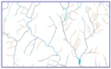
An ongoing project by the MassDEP GIS Program to redelineate surface water supply watersheds using digital terrain models is adding additional streams within the newly delineated watersheds. These streams are from the MassDEP Wetlands datalayer with some additional on screen digitizing from the 2005 Color OrthoPhotos. Streams added from this process are generally coded as intermittent unless field verification proves otherwise. In 2007 the outlines of all reservoirs were replaced with those from the MassDEP Wetlands datalayer so either dataset can be used with the SWP Zones datalayer. In 2008 field verified streams for the Wachusett Reservoir watershed were provided by DCR West Boylston GIS staff and added.
Existing USGS 1:25000 Hydrography
Hydrologic Connections from DEP Wetlands
MassDEP Hydrography with Local Resolution Streams
All of the digitized quadrangles were checkplotted at 1:25,000. The 1:25,000 DLG quadrangles were randomly checkplotted. Each of the quadrangles was edgematched to its neighboring quads. The scanned hydrography was compared both to the source mylar and to the paper quadrangles to ensure completeness.
For the December 2003 update, the layer was extracted from the Quad library and dissolved into a single coverage, which was dissolved on all items after the SOURCE field was dropped. Most slivers, gaps, and other artifacts left over from the quad tiling scheme were removed. Some codes were also refined. Edits were preformed by MassGIS and Department of Environmental Protection (DEP) GIS Group staff.
The high resolution streams from the DEP Wetlands datalayer were field verified and edited mostly in the upper reaches of the watersheds where they crossed roads or if the natural flow wasn’t apparent.
Attributes
The layer contains both a polygon and arc feature class. The modified DLG coding scheme is extensive and includes a wide variety of features, including ponds, cranberry bogs, impoundments, wetlands, tidal flats, dams, streams, and aqueducts. Only data from the DLGs have been coded this completely. Data from other sources have been coded to include ponds and streams and in the case of data from the scanned quads, wetlands.
Pond and Lake Inventory System (PALIS) IDs are unique codes which were added to ponds and lakes by DEP GIS in conjunction with the DEP Division of Watershed Management using identification codes developed by the Pond and Lakes Inventory System. For historical reasons, some wetland polygons have PALIS IDs. PALIS IDs were also given to impoundment areas along rivers and when necessary closure lines were added.
Since the data now comes from different sources, the attribute SOURCE was added to differentiate which program/entity provided the feature. An attribute for the approximate NHD resolution was added to aid in future input into NHD.
The fields in the polygon attribute table are:
| Field name | Type | Description |
|---|---|---|
| MINOR_TOT | Text (15) | Concatenated feature code |
| POLY_CODE | Number (10) | Generalized code based on MINOR_TOT simplified to these 9 codes: 0 - LAND/ISLAND/DAM/AQUEDUCT 1 - RESERVOIR (with PWSID) 2 - WETLAND, MARSH, SWAMP, BOG 3 - SUBMERGED WETLANDS 4 - CRANBERRY BOG 5 - SALT WETLANDS 6 - LAKE, POND, WIDE RIVER, IMPOUNDMENT 7 - TIDAL FLATS, SHOALS 8 - BAY, OCEAN 9 - INUNDATED AREA |
| PWSID | Text (11) | DEP public water supply identification number |
| PALIS_ID | Number (6) | A unique ID from the Ponds and Lakes Inventory System |
| SOURCE | Text (12) | Program Source for the feature: USGS/MGIS – Original 1:25,000 Hydrography DEPGIS – Added from DEP Wetlands by DEP GIS staff DCRGIS – From DEP Wetlands and edits/verified by DCR staff |
| MINOR_NUM | Number (15) | Same as MINOR_TOT, as integer |
| RESOLUTION | Text (12) | NHD corresponding resolution: HIGH - Nominally > 1:25,000 LOCAL - < 1:25,000, nominally 1:12,000, some at 1:5,000 |
| NAME | Text (50) | Feature name, from PALIS and USGS quads |
The fields in the arc attribute table are:
| Field name | Type | Description |
|---|---|---|
| MINOR_TOT | Text (12) | Concatenated feature code |
| ARC_CODE | Number (10) | Generalized code based on MINOR_TOT simplified to these codes: 1 - SHORELINE 2 - CLOSURE LINE 3 - APPARENT WETLAND LIMIT 4 - STREAM 5 - INTERMITTENT STREAM 6 - DITCH, CANAL 7 - AQUEDUCT 8 - DAM 9 - INTERMITTENT/INDEFINITE SHORELINE 10 - MAN-MADE SHORELINE 11 - CHANNEL IN WATER 99 - TRANSPORT ARC 0 - UNKNOWN |
| PWSID | Text (11) | DEP public water supply identification number |
| SOURCE | Text (12) | Program Source for the feature: USGS/MGIS – Original 1:25,000 Hydrography DEPGIS – Added from DEP Wetlands by DEP GIS staff DCRGIS – From DEP Wetlands and edits/verified by DCR staff |
| MINOR_NUM | Double | Same as MINOR_TOT, as integer |
| RESOLUTION | Text (12) | NHD corresponding resolution: HIGH - Nominally > 1:25,000 LOCAL - < 1:25,000, nominally 1:12,000, some at 1:5,000 |
| NAME | Text (100) | Feature name, from SARIS (where SARISCODE is populated) and USGS quads |
| LEN | Double | Feature length in meters |
| SARISNAME | Text (30) | Feature name from SARIS, where SARISCODE is populated |
| SARISCODE | Text (10) | SARIS code from MassDEP's Stream and River Inventory System table |
The following table lists all the possible MINOR_TOT/MINOR_NUM codes for a POLYGON FEATURE.
These codes have been extracted and concatenated from the USGS DLG major/minor pairs.
| MINOR_TOT/NUM | DESCRIPTION | MINOR_TOT/NUM | DESCRIPTION |
|---|---|---|---|
| 101 | RESERVOIR | 115422 | FLATS/CORAL REEF |
| 102 | COVERED RESERVOIR | 115616 | FLATS-NAVIGABLE |
| 105 | INUNDATION AREA | 406618 | DAM-EARTHEN |
| 106 | FISH HATCHERY/FARM | 410115 | ROCKS/FLATS |
| 107 | INDUST WATER IMPOUND | 412111 | STREAM/MARSH |
| 109 | SEWAGE DISP POND | 412115 | STREAM FLATS |
| 111 | MARSH/WETLAND | 412612 | STREAM-SUNKEN |
| 114 | CRANBERRY BOG | 415604 | AQUEDUCT IN TUNNEL |
| 115 | FLATS | 419616 | CHANNEL-NAVIGABLE |
| 116 | BAY/ESTUARY/GULF | 421007 | LAKE OR POND |
| 124 | FILTRATION POND | 421101 | POND/RESERVOIR |
| 400 | RAPIDS | 421111 | POND WETLAND |
| 401 | FALLS | 421609 | UNSURVEYED POND |
| 402 | GRAVEL PIT W/WATER | 421610 | POND-INTERMITTENT |
| 404 | PUMPING STATION | 421612 | POND-SUNKEN |
| 406 | DAM/WEIR | 421618 | POND-EARTHEN |
| 408 | SPILLWAY | 421619 | LAKE OR POND |
| 410 | ROCK | 421625 | LAKE OR POND |
| 412 | STREAM | 421628 | LAKE OR POND |
| 414 | DITCH/CANAL | 422115 | CORAL REEFS/FLATS |
| 415 | AQUEDUCT | 610402 | INTERMIT PIT W/WATER |
| 416 | FLUME | 610421 | INTERMITENT POND |
| 419 | CHANNEL IN WATER | 612111 | SUBMERGED MARSH |
| 421 | LAKE OR POND | 618101 | RESERVOIR |
| 422 | CORAL REEF | 619412 | STREAM |
| 999 | LAND/ISLAND | 619421 | LAKE OR POND |
| 7105 | INUNDATION AREA | 101111612 | SUBMERGED RES MARSH |
| 7111 | MARSH/WETLAND | 101619625 | RESERVOIR |
| 101619 | RESERVOIR | 10500711 | INUN AREA/MARSH |
| 102111 | COV RESERVOIR/MARSH | 105111007 | INUN AREA/MARSH |
| 105007 | INUNDATION AREA | 111007105 | MARSH/INUN AREA |
| 105111 | INUN AREA/MARSH | 111007612 | MARSH-SUBMERGED |
| 109421 | SEWAGE POND/POND | 111007625 | MARSH/WETLAND |
| 109611 | SEWAGE POND-ABAND | 111105007 | MARSH/INUN AREA |
| 109619 | SEWAGE POND | 111114007 | MARSH/CRANBERRY BOG |
| 111007 | MARSH/WETLAND | 111612007 | MARSH-SUBMERGED |
| 111105 | MARSH/INUN AREA | 111612421 | POND MARSH-SUBMERGED |
| 111114 | MARSH/CRANBERRY BOG | 111612619 | MARSH-SUBMERGED |
| 111608 | MARSH-SALT | 11461625 | MARSH-SUBMERGED |
| 111612 | MARSH-SUBMERGED | 114007111 | CRANBERRY BOG/MARSH |
| 114007 | CRANBERRY BOG | 114111007 | CRANBERRY BOG/MARSH |
| 114111 | CRANBERRY BOG/MARSH | 421111007 | POND MARSH |
| 115007 | FLATS | 421619625 | LAKE OR POND |
| 115116 | FLATS | 421625619 | LAKE OR POND |
| 115116 | FLATS/BAY | 619625415 | AQUEDUCT |
| 115410 | FLATS/ROCK | 619625421 | LAKE OR POND |
| 115412 | FLATS/STREAM | 101111612625 | RES MARSH-SUBMERGED |
| 115421 | FLATS/POND |
The following table lists all the possible MINOR_NUM/MINOR_TOT codes for an ARC FEATURE. These codes have been extracted and concatenated from the USGS DLG major/minor pairs.
| MINOR TOT/NUM | DESCRIPTION | MINOR TOT/NUM | DESCRIPTION |
|---|---|---|---|
| 109 | SEWAGE DISP/FILT BED | 406618 | DAM/WEIR-EARTHEN |
| 200 | SHORELINE | 412007 | STREAM |
| 201 | MANMADE SHORELINE | 412009 | STREAM |
| 202 | CLOSURE LINE | 412202 | STREAM CLOSURE LINE |
| 203 | INDEFINITE SHORELINE | 412601 | STREAM-UNDERGROUND |
| 204 | APPARENT LIMIT | 412604 | STREAM-TUNNEL |
| 210 | TRANSPORT ARC | 412609 | STREAM-UNSURVEYED |
| 300 | SPRING | 412610 | STREAM-INTERMITTENT |
| 401 | FALLS | 414009 | DITCH/CANAL |
| 405 | WATER INTAKE | 414017 | DITCH/CANAL |
| 406 | DAM/WEIR | 414610 | CANAL-INTERMITTENT |
| 407 | CANAL LOCK | 414611 | CANAL-ABANDONED |
| 408 | SPILLWAY | 415601 | AQUEDUCT-UNDERGROUND |
| 409 | GATE | 415604 | AQUEDUCT-TUNNEL |
| 412 | STREAM | 415605 | AQUEDUCT RIGHT BANK |
| 414 | DITCH/CANAL | 415611 | AQUEDUCT-ABANDONED |
| 415 | AQUEDUCT | 415612 | AQUECUDT-SUBMERGED |
| 416 | FLUME | 601412 | UNDERGROUND STREAM |
| 419 | CHANNEL IN WATER | 605009 | RIGHT BANK |
| 422 | CORAL REEF | 605201 | RIGHT BANK-MANMADE |
| 605 | RIGHT BANK | 606009 | LEFT BANK |
| 606 | LEFT BANK | 606201 | LEFT BANK-MANMADE |
| 999 | UNKNOWN OR NEAT LINE | 610200 | INTERMITTENT SHORE |
| 7204 | APPARENT LIMIT | 610412 | INTERMITTENT STREAM |
| 9606 | LEFT BANK | 610414 | INTERMITTENT CANAL |
| 200009 | SHORELINE | 610421 | INTERMITTENT POND |
| 200201 | MANMADE SHORELINE | 200618406 | SHORE/EARTHEN DAM |
| 200606 | LEFT BANK/SHORE | 201009020 | MANMADE SHORE |
| 200610 | INTERMITTENT SHORE | 201020002 | MANMADE SHORE |
| 201002 | MANMADE SHORELINE | 201020605 | MANMADE RIGHT BANK |
| 201009 | MANMADE SHORELINE | 201605020 | MANMADE RIGHT BANK |
| 201020 | MANMADE SHORELINE | 201606009 | MANMADE LEFT BANK |
| 201605 | MANMADE RIGHT BANK | 201606020 | MANMADE LEFT BANK |
| 201606 | MANMADE LEFT BANK | 202412617 | CLOS LINE/STR UNDERP |
| 202412 | CLOSURE LINE/STREAM | 406009017 | DAM/WEIR |
| 203625 | INDEFINITE SHORE | 406618200 | DAM-EARTHEN/SHORE |
| 204007 | APPARENT LIMIT | 412610009 | STREAM-INTERMITTENT |
| 204009 | APPARENT LIMIT | 412610202 | INT STREAM CLOSURE |
| 406009 | DAM/WEIR | 412610617 | INT STREAM UNDERPASS |
| 406017 | DAM/WEIR | ||
| 406200 | DAM/SHORE |
Source of 1:25,000 Hydrography from USGS
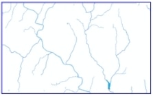
Source is for features coded as "USGS/MGIS" in the SOURCE field. Some of these features may have been modified by on-screen digitizing and/or enhanced with data from the MassDEP Wetlands (1:12,000) layer. See the SOURCE fields in the polygon and arc layers for specific sources. Also see the status map for the pre-MassDEP-enhanced hydrography data.
(USGS QUAD# - SOURCE)
Source Key:
DLG = USGS Digital Line Graph
SCN = Scanned USGS mylar
DIG = Digitized from 1:25,000 USGS topographic maps
CNR = Data from Connecticut modified by MassGIS
1 - DLG
2 - SCN
3 - SCN
4 - DLG
5 - DLG
6 - DLG
7 - DLG
8 - SCN
9 - SCN
10 - DLG
11 - SCN
12 - SCN
13 - SCN
14 - SCN
15 - SCN
16 - DLG
17 - SCN
18 - SCN
19 - SCN
20 - SCN
21 - SCN
22 - DLG
23 - SCN
24 - SCN
25 - SCN
26 - SCN
27 - SCN
28 - DLG
29 - SCN
30 - SCN
31 - SCN
32 - SCN
33 - SCN
34 - DLG
35 - SCN
36 - SCN
37 - SCN
38 - SCN
39 - SCN
40 - CNR
41 - SCN
42 - SCN
43 - SCN
44 - SCN
45 - SCN
46 - CNR
47 - DLG
48 - SCN
49 - SCN
50 - SCN
51 - SCN
52 - CNR
53 - DLG
54 - SCN
55 - SCN
56 - SCN
57 - SCN
58 - CNR
59 - DLG
60 - SCN
61 - SCN
62 - SCN
63 - SCN
64 - DLG
65 - DLG
66 - SCN
67 - SCN
68 - SCN
69 - SCN
70 - DLG
71 - DLG
72 - DLG
73 - DLG
74 - DLG
75 - DLG
76 - DLG
77 - DLG
78 - DLG
79 - DLG
80 - DLG
81 - DLG
82 - DLG
83 - DLG
84 - DLG
85 - DLG
86 - DLG
87 - DLG
88 - SCN
89 - DLG
90 - DLG
91 - DLG
92 - DLG
93 - DLG
94 - SCN
95 - DLG
96 - DLG
97 - SCN
98 - SCN
99 - SCN
100 - SCN
101 - SCN
102 - DLG
103 - DLG
104 - SCN
105 - SCN
106 - SCN
107 - SCN
108 - SCN
109 - DLG
110 - DLG
111 - DLG
112 - DLG
113 - DLG
114 - SCN
115 - SCN
116 - SCN
117 - SCN
118 - SCN
119 - DLG
120 - DLG
121 - DLG
121-S - DLG
122 - DLG
123 - DLG
124 - DLG
125 - SCN
126 - SCN
127 - SCN
128 - SCN
129 - SCN
130 - DLG
131 - DLG
132 - DLG
132-S - DLG
133 - DLG
134 - DLG
135 - DLG
136 - DLG
137 - DLG
138 - DLG
139 - DLG
140 - DLG
141 - SCN
142 - SCN
143 - SCN
144 - DLG
145 - DIG
146 - DLG
147 - DLG
148 - DLG
149 - DLG
150 - DLG
151 - DLG
152 - DLG
153 - SCN
154 - SCN
155 - SCN
156 - DLG
157 - DIG
158 - DIG
158-S - DIG
159-E - DLG
159-W - DLG
160 - DLG
161 - DLG
161-E - DLG
162 - DLG
163 - DLG
164 - DLG
165 - DLG
166 - DIG
167 - DIG
168-E - DLG
168-W - DLG
169 - DLG
170 - DLG
171 - DLG
172 - DLG
173 - DIG
173-E - DIG
173-S - DIG
173-SE - DIG
174 - DLG
174-N - DLG
175 - DLG
176 - DLG
176-S - DLG
177 - DIG
178 - DLG
179 - DLG
179-N - DLG
180 - DIG
180-S - DIG
181 - DLG
182 - DLG
182-E - DLG
183 - DLG
184 - DLG
184-N - DLG
185 - DLG
186 - DLG
186-W - DLG
187 - DIG
187-E - DIG
188 - DIG
188-E - DIG
188-S - DIG
188-SE - DIG
189 - DLG
Note that these hydrography layers do not have feature names (e.g., "Quabbin Reservoir" or "Connecticut River") as attributes. To label the features in these layers, use the annotation in the HYDRO subclass of the Geographic Place Names layer.
Maintenance
The MassDEP GIS Program maintains the MassDEP Hydrography layers.
The 2007 update includes new streams within the watersheds of active sources in Lynn, Peabody, Danvers, Middleton, Beverly, Manchester, and Ipswich.
The 2008 update includes new streams within the watersheds of active sources in Gloucester, Rockport, Ipswich, Newburyport, Amesbury, Haverhill, Andover, North Andover, Wakefield, Winchester, Woburn, Burlington, Lincoln, Concord, Leominster, Fitchburg, Worcester, Greenfield and the entire Wachusett Reservoir watershed. Please refer to the SWP Watersheds and SWP Zones datalayers for additional information on this project.
The 2009 update (released in March 2010) includes new streams within the watersheds of active and inactive sources in Ashburnham, Winchendon, Gardner, Fitchburg (North), Hudson, Marlborough, Westboro, Milford, Braintree, Hingham, Weymouth, Abington, Rockland, Brockton, Attleboro, Somerset, Fall River, Falmouth, Plymouth, Wareham, New Bedford, Taunton, and Cambridge. The code for closure lines was split into 2 different codes, where arc_code = 2 was assigned to features between tidal flats and bay/ocean, and arc_code = 12 was assigned to closure lines between different types of wetlands features. A minor_tot of 7204 was given to the tidal flat features. Some changes were made to the Quabbin Reservoir and tributaries, along with some covered reservoirs in Weston, Milton and Medford, at the request of the MWRA GIS Program. A general cleanup was also performed to address logical errors in the original dataset, like a stream inside an open water feature or a pond surrounded by a wetland line feature.
The March 2017 update added the NAME fields to both feature classes. MassGIS added these fields based on PALIS and SARIS codes. If features did not have these codes, annotation and USGS topographic quad imagery were used as sources. The LEN, SARISNAME and SARISCODE fields were also added at this time.
The April 2017 update includes MassDEP revisions to Surface Water Supply Protection (SWP) Watersheds in the MassDEP Western Region (except for the Cobble Mountain Complex and the Quabbin Reservoir) as well as the watersheds for Mill Pond (Burlington Water Dept.), Old Oaken Bucket Pond (Scituate Water Division) and Silver Lake (Brockton Water Commission). Other MassDEP updates include linework for eleven missing stream segments, as provided by the Division of Fish and Game. These segments and related edits nearby may be found in the Chicopee, Merrimack, Millers, Nashua, SuAsCo and South Coastal basins.
The following edits were incorporated in December 2019:
- Lake Rico (PALIS 62148), Taunton: Added to HYDRO25K_POLY and ARC, replacing old polygons and linework in that area.
- Lake Ellis (PALIS 35023), Athol: Renamed from "Ellis Pond".
- Petersons Saw Mill Pond (PALIS 94111), Duxbury: Renamed from "North West Duxbury Pond".
- Nipmuc Pond (PALIS 51111), Mendon: Renamed from "Nipmuck Pond".
- Assabet River, Northborough: The word "Reservoir" was removed from the name.
- Betty Pond (PALIS 35010), Templeton: Renamed from "Brazell Pond".
- Cochituate Brook (SARIS 8248010), Framingham: Renamed from "Unnamed Trib".
These changes were based on GNIS names and other input and made in conjunction with MassDEP.
For other hydrographic features, also see the MassDEP Wetlands (1:12,000), Hydrography (1:100,000) and Major Ponds and Major Streams layers.