Downloads
(.zip file, 832 KB):
- ESRI Shapefiles (arc and polygon)
- ArcMap layer files (.lyr) (for ArcMap 10 and 9.0*)
* The data sources in the LYR for Arc 9 will need to be reset)
Overview
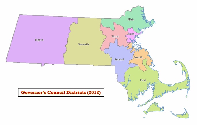
These boundaries took effect in January 2012, and members are based on the results of the November 2018 elections. The name of the statewide datalayers are GOVCOUNCIL2012_POLY and GOVCOUNCIL2012_ARC.
Production
Staff at the Massachusetts General Court Special Joint Committee on Redistricting developed this layer with its contractor, Caliper Corp. (Newton, MA), using Maptitude for Redistricting software. MassGIS appended the 1:100,000 coastline and state outline and added the Councilor's name and party attributes.
Attributes
The GOVCOUNCIL2012_POLY attribute table has the following fields:
| FIELD NAME | DESCRIPTION |
|---|---|
| DIST_NUM | Numeric district code from redistricting committee |
| DIST_NAME | Name of district |
| MEMBER | Name of Councilor |
| PARTY | Political party of councilor (D = Democrat) |
In the GOVCOUNCIL2012_ARC attribute table, the field OUTLINE is coded as follows:
- 0 = internal district boundaries
- 1 = state
- 2 = coastline
Maintenance
These data layers have been superseded by the 2021 Governor's Council Districts.