Downloads
Overview
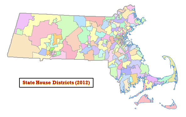
The Massachusetts House Legislative Districts datalayer reflects the state House of Representatives district boundaries as defined by Massachusetts General Laws, Chapter 57: Section 4. These 160 districts are those used in the Fall 2012 elections and beyond, until they are redrawn based on the 2020 decennial Census.
The names of the statewide datalayers are HOUSE2012_POLY (polygons) and HOUSE2012_ARC (arcs). These replace the previous HOUSE02_ARC and HOUSE02_POLY layers.
Production
Staff at the Massachusetts House of Representatives developed this layer with its contractor, Caliper Corp. (Newton, MA), using Maptitude for Redistricting software. MassGIS appended the 1:100,000 coastline and state outline and added the attribute fields. Election results are obtained from the Secretary of State.
In March 2018 MassGIS made minor edits to boundaries in Boston to reflect corrected data from the City of Boston. In November 2018 MassGIS made minor edits to boundaries statewide where they were offset enough from survey-based municipal lines to result in address points being assigned to the wrong district. These boundary changes have not been incorporated into U.S. Census geography that forms the basis for this layer. In January 2021, the layer was updated to reflect the results of the latest elections.
Attributes
The HOUSE2012_POLY attribute table has the following fields:
| FIELD NAME | WIDTH / TYPE | DESCRIPTION |
|---|---|---|
| DIST_CODE | 10 / C | District code, from Redistricting Committee |
| REPDISTNUM | 5 / I | Unique number for each district |
| REP_DIST | 40 / C | Name of the district |
| REP_FIRST | 14 / C | First name of representative |
| REP_LAST | 25 / C | Last name of representative |
| REP_PARTY | 3 / C | Political party of representative |
| REP | 40 / C | Rep.'s full name and party |
| URL | 150 / C | Rep.'s Web site address |
In the HOUSE2012_ARC attribute table, the field OUTLINE is coded as follows:
- 0 = Internal district boundaries
- 1 = State
- 2 = Coastline
Maintenance
*** These data layers have been superseded by the 2021 state House districts.
Last updated on March 10, 2022.
Also see the current state Senate and Congress data layers.
Visit the Commonwealth's Find Your Legislators page