Downloads
Each download includes an ArcMap 10 layer (LYR) file and Excel spreadsheets.
Overview

The MassDEP Division of Watershed Management (DWM), Watershed Planning Program (WPP) 2012 Integrated List of Waters (305(b)/303(d)) data layer represents the combined reporting elements for the 2012 cycle of both sections 305(b) and 303(d) of the Federal Clean Water Act (CWA). The objective of this statute is to restore and maintain the chemical, physical, and biological integrity of the Nation's waters. As one step toward meeting this goal each state must administer a program to monitor and assess the quality of its surface waters and provide periodic status reports to the U.S. Environmental Protection Agency (EPA), the U.S. Congress, and the public.
Section 305(b) of the CWA codifies the process whereby waters are evaluated with respect to their capacity to support designated uses as defined in the Massachusetts Surface Water Quality Standards. These uses include aquatic life, fish consumption, drinking water, shellfish harvesting, primary (e.g., swimming) and secondary (e.g., boating) contact-recreation, and aesthetics. The 305(b) process entails assessing each of these uses, where applicable, for rivers, lakes and coastal waters. Where possible, causes and sources of use impairment are also identified. Once a water body is identified as impaired by a pollutant, MassDEP is required under Section 303(d) of the CWA, and the implementing regulations at 40 CFR 130.7, to develop a pollutant budget designed to restore the health of the impaired water body. The process of developing this pollutant budget, generally referred to as a Total Maximum Daily Load (TMDL), includes identifying the cause (type of pollutant) and source (where the pollutant comes from), determining how much of the pollutant is from direct discharges (point sources) or indirect discharges (non-point sources), determining the maximum amount of the pollutant that can be discharged to a specific water body to meet water quality standards, and developing a plan to meet that goal. In short a TMDL is a clean-up plan that is required under the CWA to restore water quality and enable waters to attain designated uses.
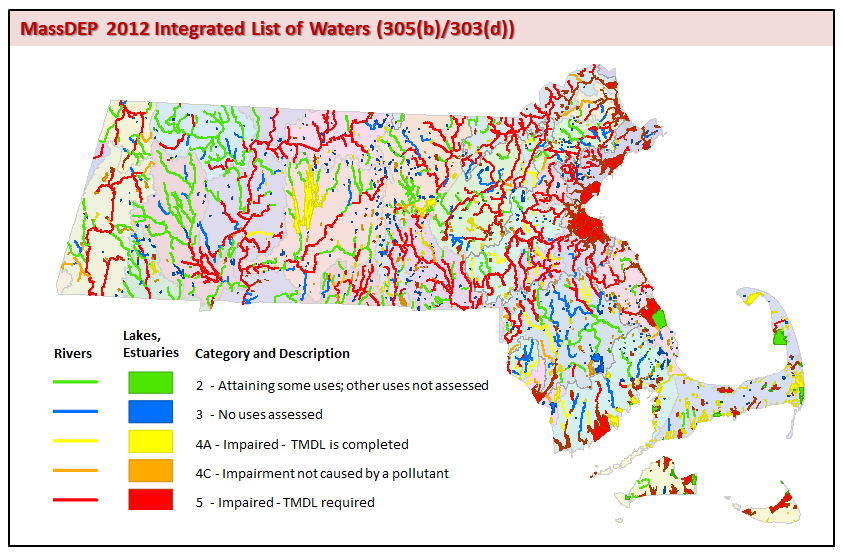
In November 2001 EPA released guidance to the states for the preparation of an optional report that would combine reporting elements of both sections 305(b) and 303(d) of the CWA. This combined report format, the Integrated List of Waters report, allows states to provide the status of all their assessed waters in a single, multi-part list. States list each waterbody or segment thereof in one of the following five categories:
Category 1) Unimpaired and not threatened for all designated uses;
Category 2) Unimpaired for some uses and not assessed for others;
Category 3) Insufficient information to make assessments for any uses;
Category 4) Impaired for one or more uses, but not requiring the calculation of a Total Maximum Daily Load (TMDL); (impairment due to "pollution" such as low flow, habitat alterations or non-native species infestations).
Category 5) Impaired for one or more uses and requiring a TMDL (impairment due to pollutant(s) such as nutrients, metals, pesticides, solids and pathogens).
Waters listed in Category 5 constitute the 303(d) List. The formulation of the 303(d) List includes a more rigorous public review and comment process than does reporting under Section 305(b), and the final version of the list must be formally approved by the EPA. The remaining four categories are submitted in fulfillment of the requirements under Section 305(b), essentially replacing the old 305(b) Report format. Massachusetts formulated integrated lists in accordance with EPA guidance for the 2002, 2004, 2006, 2008, 2010, and, most recently, the 2012 listing cycles. The EPA subsequently approved each of these.
The 2012 Integrated List of Waters (305(b)/303(d)) data layer is the spatial representation of the river, lake, and estuary segments assessed and summarized in the Massachusetts Year 2012 Integrated List of Waters report to the EPA developed pursuant to sections 305(b) ("Water Quality Inventory") and 303(d) of the Federal Clean Water Act. This report or any previous or subsequent reports can be obtained by contacting Arthur Johnson at the MassDEP, Division of Watershed Management, 627 Main St., Worcester, MA 01608. Electronic versions of the Massachusetts Year 2012 Integrated List of Waters report can be found on the MassDEP website at Total Maximum Daily Loads (TMDLs).
Data Layers
The Massachusetts 2012 Integrated List of Waters (305(b)/303(d)) data layer comprises two features classes:
- the IL_2012_ARC (alias: Water Body Segments - Rivers (arcs)) for linear features (rivers and a few estuaries) and
- the IL_2012_POLY (alias: Water Body Segments - Lakes, Estuaries (polygons)) for polygon features (lakes and estuaries).
Tables and Relationship Classes:
- A related table, IL_ADB_2012, contains each use attainment status, and when impaired the cause(s), source(s), and TMDL(s) associated with each segment. The IL_ADB_2012 table has a many-to-one relationship with both the arc and polygon features. That relationship is built into the geodatabase with the relationship classes IL_ARC_TO_ADB_2012 and IL_POLY_TO_ADB_2012. Users of the shapefile and dBASE versions of the data must establish these relates using the AU_ID. Because of the many-to-one relationship the IL_ADB_2012 table is not suitable for summarizing certain data (e.g., size, number of segments, etc.).
- A second table, IL_SEGDEF_2012, contains information that can be used for summarizing certain data (e.g., classification, size, number of segments, etc.).
Also included is a feature class (IL_DWMWPP_WATERSHEDS_POLY) (alias: DWM WPP Integrated List Watershed Delineations) showing the DWM/WPP watershed delineations.
Production
Definitions of water body segments are an amalgamation of information from various databases or data sources within DWM/WPP (SegDef, ADB, TMDL/ATTAINS databases). The geo-referencing of individual segments relied on the use of information that was derived from: USGS 1:25,000 Topographic Maps, National Oceanic and Atmospheric Administration Nautical Charts at several scales, and the "Planimetry of Harbors for the 1984 305(b) Report". Where definitions were still ambiguous after using these references, the DWM/WPP staff members were consulted to define and geo-reference individual water body segments.
River Segments: Individual river segments are represented as one or more lines in the arc feature class. Linework was derived from the MassGIS 1:25,000 hydrography based on USGS topographic maps. Additional on-screen editing was performed as needed using USGS topographic quadrangles and/or MassGIS 2001/2003 Aerial Images as a base map for all river segments.
Lake Segments: Lake segments are represented as one or more polygons in the polygon feature class. Lake segment polygons were selected from the MassGIS 1:25,000 hydrography layer, where available, and placed in a separate file where additional editing (typically closure lines) may have been performed. In some cases segments were drawn and/or edited to reflect current conditions using USGS topographic quadrangles, and/or MassGIS 2001/2003 Aerial Images as the base map.
Estuary Segments: Estuary segments are represented as single lines, polygons, or both lines and polygons (some estuary segments have multiple lines/polygons representing one water body segment). Where available, arcs were derived from the MassGIS 1:25,000 hydrography based on the name and description of each estuarine segment. Additional on-screen digitizing to close polygons, complete arcs or draw lines and polygons to reflect waters actually assessed, but that may not have been represented in the hydrography layer, was completed using the USGS topographic quadrangles as the base map.
All Segments (Rivers, Lakes, Estuaries): River, lake, and estuary features, regardless of their derivation, were combined into two single statewide feature classes, one for lines (IL_2012_ARC alias: Water Body Segments - Rivers (arcs)) and one for polygons (IL_2012_POLY alias: Water Body Segments - Lakes, Estuaries (polygons)). No two river segments overlap nor do any two lake features nor do any two estuary features. However, until they are edited in future cycles, there are instances where a river line segment does overlap with the polygon representing a lake segment (typically an impoundment).
Attributes
Except for standard GIS items (e.g., Shape_Length (meters), Shape_Area (square meters), Shape, OBJECTID, FID), all attributes were obtained from the DWM/WPP and are presented in the table IL_ADB_2012. This table has a many-to-one relationship with individual features in the IL_2012_ARC and IL_2012_POLY features classes. Only attributes that are the same for every record concerning a feature were added to the attribute table of the feature set. For example, a water body segment has only one name (AU_ID) and description but each individual segment is assessed for multiple uses and will, therefore, be repeated multiple times in the ADB table if there are more than one cause and/or source of impairment for a given use. The IL_ADB_2012 table can be related to geographic features using the AU_ID. Since some individual water body segments (n~14) are represented as more than a single geographic feature (a few estuaries are currently represented by a combination of both a line and a polygon and a few impoundments are still represented with both a line and a polygon). Care should be taken when summarizing data to avoid double counting. The additional table (IL_SEGDEF_2012) can be used for summarizing data and can be related to geographic features using the AU_ID.
Fields in the IL_2012_POLY and IL_2012_ARC attribute tables are as follows:
| Field name | Description |
|---|---|
| WBID_2012 | Assessment Unit ID (AU_ID) with the reporting cycle year. |
| Watershed | The MassDEP DWM WPP watershed delineations are based on the MassGIS Major Basins layer, but modified to reflect surface drainage areas for use with the MassDEP Integrated List of Waters report by the WPP. For example, a portion of the Cape Cod Watershed Area was changed to reflect its drainage into Buzzards Bay, resulting in shape changes for both the Cape Cod and Buzzards Bay watershed delineations. In general, the watershed name is based on the Massachusetts Stream and River Inventory System (SARIS) that includes all Massachusetts river basins and coastal drainage areas (Halliwell et al. 1982). The WPP watershed name Boston Harbor (Proper) does not appear in the MassGIS Major Basins layer or the SARIS list of watersheds; it refers to the harbor itself. Three drainage area types are further described in SARIS as follows: River Basin: Major inland river basin. River Basin and Coastal Drainage Area: Major inland river basin coupled with smaller areas draining directly to coastal waters within the general geographic area of the associated river basin. Coastal Drainage Area: Subdivisions of the coastal drainage system that have been partitioned into specific geographic areas. These areas all drain to coastal waters but may have multiple small-scale drainages. |
| Waterbody | Water body names are based on SARIS, PALIS, or CAMIS. SARIS = Stream and River Inventory System, PALIS = Pond and Lake Inventory System, CAMIS = Coastal and Marine Inventory System. |
| AU_ID | Water body segment identification code for the 2012 cycle of the Massachusetts Integrated List of Waters report (Assessment Unit ID). |
| Location1 | Description of the water body (Assessment Unit) segment. |
| Location2 | Continuation of the location description if LOCATION1 exceeds 254 characters. |
| WaterCode | Unique water body code based on SARIS, PALIS, or CAMIS inventory coding systems. |
| WaterType | Water body segment type:- River (including streams, brooks, etc.), Lake (including ponds, reservoirs, etc.), Estuary |
| AU_Size | Size of the water body segment (Assessment Unit size). (Some historic values in this field may be based on measurements made with map wheels and other techniques including, but not limited to, planimetry using USGS Quad sheets at a scale of 1:25,000. New values are generated using GIS.) AU_Size is the size reported to the EPA for the entire water body segment (within the state), not the size of individual arcs or polygons. |
| Size_Unit | Water body size units: - Miles (Rivers) - Acres (Lakes) - Square Miles (Estuaries) |
| Class | Water body class as defined in the Massachusetts Surface Water Quality Standards (314 CMR 4.00) that can be found at Water Resources Regulations and Standards. (Clarification Note: Classification is reflective of version of Standards available at time when assessment decisions were made.) |
| Qualifier | Class qualifiers (e.g., WWF [warm water fishery], CWF [cold water fishery], etc.) assigned to water body as defined in the Massachusetts Surface Water Quality Standards (314 CMR 4.00). (Clarification Note: Classification is reflective of version of Standards available at time when assessment decisions were made.) |
| Category | The category of the water body segment in the Massachusetts Year 2012 Integrated List of Waters report; category descriptions are as follows: Category 1: Attaining all designated uses. Category 2: Attaining some of the designated uses and insufficient or no data and information is available to determine if the remaining uses are attained. Category 3: Insufficient or no data and information to determine if any designated uses are attained. Category 4A: Impaired for one or more designated uses but does not require the development of a TMDL: TMDL has been completed. Category 4B: Impaired for one or more designated uses but does not require the development of a TMDL: Other pollution control requirements are reasonably expected to result in the attainment of designated uses. Category 4C: Impaired for one or more designated uses but does not require the development of a TMDL: Impairment is not caused by a pollutant. Category 5: Impaired for one or more designated uses, requires the development of a TMDL: Impairment is caused by a pollutant. |
| TMDL_count | The number of unique DWM/WPP TMDLs approved for this segment. |
Fields in the IL_ADB_2012 attribute table are as follows:
| Field name | Description |
|---|---|
| Watershed | The MassDEP DWM WPP watershed delineations are based on the MassGIS Major Basins layer, but modified to reflect surface drainage areas for use with the MassDEP Integrated List of Waters report by the WPP. For example, a portion of the Cape Cod Watershed Area was changed to reflect its drainage into Buzzards Bay, resulting in shape changes for both the Cape Cod and Buzzards Bay watershed delineations. In general, the watershed name is based on the Massachusetts Stream and River Inventory System (SARIS) that includes all Massachusetts river basins and coastal drainage areas (Halliwell et al. 1982). The WPP watershed name Boston Harbor (Proper) does not appear in the MassGIS Major Basins layer or the SARIS list of watersheds; it refers to the harbor itself. Three drainage area types are further described in SARIS as follows: River Basin: Major inland river basin. River Basin and Coastal Drainage Area: Major inland river basin coupled with smaller areas draining directly to coastal waters within the general geographic area of the associated river basin. Coastal Drainage Area: Subdivisions of the coastal drainage system that have been partitioned into specific geographic areas. These areas all drain to coastal waters but may have multiple small-scale drainages. |
| Waterbody | Water body names are based on SARIS, PALIS, or CAMIS. SARIS = Stream and River Inventory System, PALIS = Pond and Lake Inventory System, CAMIS = Coastal and Marine Inventory System. |
| AU_ID | Water body segment identification code for the 2012 cycle of the Massachusetts Integrated List of Waters report (Assessment Unit ID). |
| Location1 | Description of the water body (Assessment Unit) segment. |
| Location2 | Continuation of the location description if LOCATION1 exceeds 254 characters. |
| WaterCode | Unique water body code based on SARIS, PALIS, or CAMIS inventory coding systems. |
| WaterType | Water body segment type:- River (including streams, brooks, etc.), Lake (including ponds, reservoirs, etc.), Estuary |
| AU_Size | Size of the water body segment (Assessment Unit size). (Some historic values in this field may be based on measurements made with map wheels and other techniques including, but not limited to, planimetry using USGS Quad sheets at a scale of 1:25,000. New values are generated using GIS.) AU_SIZE is the size, reported to the EPA for the entire water body segment (within the state), not the size of individual arcs or polygons. |
| Size_Unit | Water body size units: - Miles (Rivers) - Acres (Lakes) - Square Miles (Estuaries) |
| Class | Class assigned to water body as described in the Massachusetts Surface Water Quality Standards (314 CMR 4.00) that can be found at Water Resources Regulations and Standards. (Clarification Note: Classification is reflective of version of Standards available at time when assessment decisions were made.) |
| Qualifier | Class qualifiers (e.g., WWF [warm water fishery], CWF [cold water fishery], etc.) assigned to water body as defined in the Massachusetts Surface Water Quality Standards (314 CMR 4.00). (Clarification Note: Classification is reflective of version of Standards available at time when assessment decisions were made.) |
| Category | The category of the water body segment in the Massachusetts Year 2012 Integrated List of Waters report; category descriptions are as follows: Category 1: Attaining all designated uses. Category 2: Attaining some of the designated uses and insufficient or no data and information is available to determine if the remaining uses are attained. Category 3: Insufficient or no data and information to determine if any designated uses are attained. Category 4A: Impaired for one or more designated uses but does not require the development of a TMDL: TMDL has been completed. Category 4B: Impaired for one or more designated uses but does not require the development of a TMDL: Other pollution control requirements are reasonably expected to result in the attainment of designated uses. Category 4C: Impaired for one or more designated uses but does not require the development of a TMDL: Impairment is not caused by a pollutant. Category 5: Impaired for one or more designated uses, requires the development of a TMDL: Impairment is caused by a pollutant. |
| Use | The uses assessed are "Aesthetics", "Fish Consumption", "Fish, other Aquatic Life and Wildlife" (habitat for fish, other aquatic life and wildlife, including for their reproduction, migration, growth and other critical functions), "Primary Contact Recreation", "Public Water Supply", "Secondary Contact Recreation", and "Shellfish Harvesting". Designated uses are defined in the Massachusetts Surface Water Quality Standards (314 CMR 4.00); see at Water Resources Regulations and Standards. |
| Attainment | Field indicating the use assessment level for this record: "Fully Supporting", "Insufficient Information", "Not Assessed", or "Not Supporting" |
| Cause | Field identifying a cause of the use impairment in this record. There are 72 different causes named in the Massachusetts Year 2012 Integrated List of Waters report. |
| POLTNT_FLG | The CWA distinguishes between “pollutants” such as nutrients, metals, pesticides, solids and pathogens that all require TMDLs and “pollution” such as low flow, habitat alterations or non-native species infestations that do not require TMDLs. The POLTNT_FLG field identifies non-pollutant stressors with an ‘N’ in the IL_ADB_2012 table to distinguish them from pollutants requiring TMDLs (marked with a ‘Y’). |
| Source | Field identifying a source related to a cause of the use impairment in this record. There are 87 different sources named in Massachusetts Year 2012 Integrated List of Waters report. |
| TMDLEPA_ID | Unique numeric identifier assigned by EPA to each approved TMDL. |
| TMDLDWM_ID | The document control number assigned by MassDEP DWM WPP for the TMDL report. This CN number is correlated to the EPA assigned TMDL ID number. |
| DWM_Title | The MassDEP DWM WPP TMDL document title. |
| Info_Name | A relate field created by combining the 'Use, Attainment, Cause, Source, and TMDLDWM_ID' fields. |
Fields in the IL_SEGDEF_2012 attribute table are as follows:
| Field name | Description |
|---|---|
| WBID_2012 | Assessment Unit ID (AU_ID) with the reporting cycle year. |
| Watershed | The MassDEP DWM WPP watershed delineations are based on the MassGIS Major Basins layer, but modified to reflect surface drainage areas for use with the MassDEP Integrated List of Waters report by the WPP. For example, a portion of the Cape Cod Watershed Area was changed to reflect its drainage into Buzzards Bay, resulting in shape changes for both the Cape Cod and Buzzards Bay watershed delineations. In general, the watershed name is based on the Massachusetts Stream and River Inventory System (SARIS) that includes all Massachusetts river basins and coastal drainage areas (Halliwell et al. 1982). The WPP watershed name Boston Harbor (Proper) does not appear in the MassGIS Major Basins layer or the SARIS list of watersheds; it refers to the harbor itself. Three drainage area types are further described in SARIS as follows: River Basin: Major inland river basin. River Basin and Coastal Drainage Area: Major inland river basin coupled with smaller areas draining directly to coastal waters within the general geographic area of the associated river basin. Coastal Drainage Area: Subdivisions of the coastal drainage system that have been partitioned into specific geographic areas. These areas all drain to coastal waters but may have multiple small-scale drainages. |
| Waterbody | Water body names are based on SARIS, PALIS, or CAMIS. SARIS = Stream and River Inventory System, PALIS = Pond and Lake Inventory System, CAMIS = Coastal and Marine Inventory System. |
| AU_ID | Water body segment identification code for the 2012 cycle of the Massachusetts Integrated List of Waters report. |
| Location1 | Description of the water body (Assessment Unit) segment. |
| Location2 | Continuation of the location description if LOCATION1 exceeds 254 characters. |
| WaterCode | Unique water body code based on SARIS, PALIS, or CAMIS inventory coding systems. |
| WaterType | Water body segment type:- River (including streams, brooks, etc.), Lake (including ponds, reservoirs, etc.), Estuary |
| AU_Size | Size of the water body segment (Assessment Unit size). (Some historic values in this field may be based on measurements made with map wheels and other techniques including, but not limited to, planimetry using USGS Quad sheets at a scale of 1:25,000. New values are generated using GIS.) SIZE is the size, reported to the EPA for the entire water body segment (within the state), not the size of individual arcs or polygons. |
| Size_Unit | Water body size units: - Miles (Rivers) - Acres (Lakes) - Square Miles (Estuaries) |
| Class | Class assigned to water body as described in the Massachusetts Surface Water Quality Standards (314 CMR 4.00); see Qualifier Class qualifiers (e.g., WWF [warm water fishery], CWF [cold water fishery], etc.) assigned to water body as defined in the Massachusetts Surface Water Quality Standards (314 CMR 4.00). (Clarification Note: Classification is reflective of version of Standards available at time when assessment decisions were made.) |
| Category | The category of the water body segment in the Massachusetts Year 2012 Integrated List of Waters report; category descriptions are as follows: Category 1: Attaining all designated uses. Category 2: Attaining some of the designated uses and insufficient or no data and information is available to determine if the remaining uses are attained. Category 3: Insufficient or no data and information to determine if any designated uses are attained. Category 4A: Impaired for one or more designated uses but does not require the development of a TMDL: TMDL has been completed. Category 4B: Impaired for one or more designated uses but does not require the development of a TMDL: Other pollution control requirements are reasonably expected to result in the attainment of designated uses. Category 4C: Impaired for one or more designated uses but does not require the development of a TMDL: Impairment is not caused by a pollutant. Category 5: Impaired for one or more designated uses, requires the development of a TMDL: Impairment is caused by a pollutant. |
| TMDL_Count | The number of unique DWM/WPP TMDLs approved for this segment. |
Fields in the IL_DWMWPP WATERSHEDS_POLY attribute table are as follows (Note: these delineations are based on MassGIS 'Major Basins' shapefile but modified by the DWM/WPP to reflect surface drainage areas for use with the Massachusetts Year 2012 Integrated List of Waters report by the WPP.):
| Field name | Description |
|---|---|
| DWM_Name | The MassDEP DWM WPP watershed delineations are based on the MassGIS Major Basins layer, but modified to reflect surface drainage areas for use with the MassDEP Integrated List of Waters report by the WPP. For example, a portion of the Cape Cod Watershed Area was changed to reflect its drainage into Buzzards Bay, resulting in shape changes for both the Cape Cod and Buzzards Bay watershed delineations. In general, the watershed name is based on the Massachusetts Stream and River Inventory System (SARIS) that includes all Massachusetts river basins and coastal drainage areas (Halliwell et al. 1982). The WPP watershed name Boston Harbor (Proper) does not appear in the MassGIS Major Basins layer or the SARIS list of watersheds; it refers to the harbor itself. Three drainage area types are further described in SARIS as follows: River Basin: Major inland river basin. River Basin and Coastal Drainage Area: Major inland river basin coupled with smaller areas draining directly to coastal waters within the general geographic area of the associated river basin. Coastal Drainage Area: Subdivisions of the coastal drainage system that have been partitioned into specific geographic areas. These areas all drain to coastal waters but may have multiple small-scale drainages. |
| DWM_Code | The watershed identification code used by the DWM/WPP for assigning water body segments (assessment units) to a watershed. These codes are assigned according to the Massachusetts Stream and River Inventory System (SARIS) -- the first two numbers of which assign 1. the major drainage system and 2. the river basin and coastal drainage area (Halliwell et al. 1982). |
| Drainage | Three drainage area types are further described in SARIS as follows: River Basin: Major inland river basin. River Basin and Coastal Drainage Area: Major inland river basin coupled with smaller areas draining directly to coastal waters within the general geographic area of the associated river basin. Coastal Drainage Area: Subdivisions of the coastal drainage system that have been partitioned into specific geographic areas. These areas all drain to coastal waters but may have multiple small-scale drainages (Halliwell et al. 1982). |
References
Halliwell, D.B., W.A. Kimball and A.J. Screpetis. 1982. Massachusetts Stream Classification Program Part I: Inventory of Rivers and Streams. Massachusetts Division of Fisheries and Wildlife, Department of Fisheries, Wildlife, and Recreational Vehicles and Massachusetts Division of Water Pollution Control, Department of Environmental Quality Engineering. Westborough, MA.
Maintenance
Once the Massachusetts Year 2012 Integrated List of Waters report is approved by EPA it becomes static and will not change. The DWM/WPP will re-use many water body segments for the 2014 assessment cycle, though new segments may be added, some may be broken into two or more segments and some may be removed or combined. The DWM/WPP will update the geo-references for the 2014 Integrated List of Waters (305(b)/303(d)) data layer where necessary. After the internal and external reviews of the 2014 cycle assessments are completed and are submitted to EPA and the public and a final Massachusetts Year 2014 Integrated List of Waters report becomes available, the geographic representations and related tables will also be made available at MassGIS. The next planned update of 305(b)/303(d) assessments and associated geo-references will be for the 2014 reporting cycle. For questions regarding the programmatic content of these data contact Arthur Johnson (508-767-2873) or Richard McVoy (508-767-2877) in the MassDEP, Watershed Planning Program.