Downloads
Overview
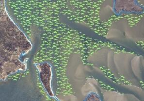
Seagrass, a form of Submerged Aquatic Vegetation (SAV), serves as important fish and wildlife habitat and assists with storage and recycling of nutrients and the stabilization of sediments. The predominant seagrass found in Massachusetts coastal waters is eelgrass (Zostera marina). The Massachusetts Department of Environmental Protection (MassDEP) began surveying seagrass in the early 1990s and the MassDEP Eelgrass Mapping Project has produced multiple phases of seagrass mapping along the Massachusetts coastline.
This second eelgrass mapping project, conducted during the period 1999-2001, included the entire Massachusetts coastline with the exception of the Elizabeth Islands (Gosnold), Billingsgate Shoals, and Mount Hope Bay. The purpose of this second coast-wide mapping effort was to determine areas where the SAV resource was decreasing in area and cover as compared to the SAV distribution mapped in the earlier 1995 project. The methods used in the 2001 project were similar to those used in 1995. One exception to this specification was the change in the delineation of apparent areas of no Zostera within polygons of the resource (i.e. holes). This change in mapping convention was derived from a better understanding of the scientific literature of the dynamics of Zostera beds which describes subtle “infra” movement within beds in response to day-to-day wave action, currents and sand migration, and storm events. The reasons the Elizabeth Islands and Mount Hope Bay were not re-mapped in 2001 is that the Elizabeth Islands are relatively pristine and without environmental stressors to the resource, and Mount Hope Bay had no Zostera found in 1995.
The layer is named EELGRASS2001_POLY.
Production
The mapping process involved the following steps:
- Acquisition of Aerial Imagery
- Photo-interpretation of SAV resources
- Fieldwork to confirm Photo-interpreted SAV features
- Compilation to Digital Orthophoto Base Map
Acquisition of Aerial Photography: Aerial imagery (Aerocolor 2448 color positive film) at a scale of 1:20,000 was acquired over the period of 1999-2001. Collecting aerial imagery under the proper environmental conditions is critical to successful benthic mapping. The image acquisition mission required collecting data at low tide, during the period of high seagrass biomass from May 15 to August 31, sun angle between 20 and 35 degrees, low water turbidity, and weather conditions of no clouds and winds less than 10 mph. The imagery was ortho-rectified at a resolution of 1 meter with 90% of the pixels accurate to within 3 meters.
Photo-interpretation: The accurate identification of SAV in aerial photographs requires visual evaluation of the fundamental elements of image interpretation (tone, color, contrast, texture and shadow). It also requires extensive experience at ground level in the particular study area. The photographic images of SAV and other benthic images vary in ways that cannot readily be modeled, described or communicated. Training for SAV photointerpretation includes: literature research, discussions with local ecologists and biologists, site visits, overflights in a small plane, and examinations of historical aerial photographs of the area.
SAV are observed best using stereo pairs of photographs and high quality stereoscopic instruments (MassDEP Wetlands Conservancy Program (WCP) uses a Cartographic Engineering Ltd. Model SB 190). SAV polygons are drafted onto overlays fixed to each photograph. Minimum mapping unit is 20 meters. SAV (and other benthic features) in a given area will present a variety of signatures depending upon the bottom sediment, depth, season and haze. Shadows from clouds or trees, turbid water, white caps, or sun glint may obscure SAV signatures in the photograph.
Fieldwork: Extensive fieldwork was required to verify that the photosignature was SAV or some other type of benthic feature (macroalgae, mussel bed, dark sand, shells, rock, or other). SAV can also be combined with any of these other benthic features. Fieldwork was conducted in a small boat using surface observation and underwater observation for which an underwater video camera system was utilized. Field notes were compiled digitally in an onboard computer equipped with real-time differentially-corrected GPS positions.
Attributes
The mapped SAV features from Phase 2 (2001) of the MassDEP Eelgrass Mapping Project were combined into a single layer (EELGRASS2001_POLY). The attribute fields for this layer are:
| FIELD | TYPE | VALUE(S) |
|---|---|---|
| HABITAT | Char | Seagrass type in 2001 delineation (eelgrass, rupia) |
| AREA_ACRES | Num | Seagrass polygon area in Acres (US) |
| AREA_M | Num | Seagrass polygon area in square meters |
Maintenance
This layer is maintained by the MassDEP Wetlands Program.
Learn more about the MassDEP Eelgrass Mapping Project.
Also see an overview of all GIS data layers in the MassDEP Eelgrass Mapping Project.