Downloads
Overview
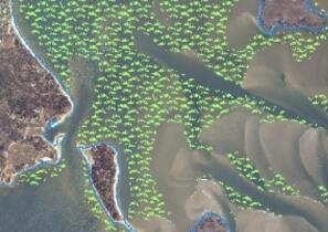
Eelgrass (Zostera marina) is the predominant seagrass, or Submerged Aquatic Vegetation (SAV) species, found in Massachusetts. Eelgrass serves as important fish and wildlife habitat and assists with storage and recycling of nutrients and the stabilization of sediments. The Massachusetts Department of Environmental Protection (MassDEP) began surveying eelgrass in the early 1990s and the MassDEP Eelgrass Mapping Project has produced multiple phases of eelgrass mapping along the Massachusetts coastline.
The feature class is named EELGRASS_PHASE6_POLY and includes data collected from 2019-2023.
Production
Digital aerial imagery covering each project area was acquired in late spring of the year the project area was assessed through a contract with the National Oceanic and Atmospheric Administration (NOAA), Office for Coastal Management.
Imagery was collected using a Microsoft/Vexcel UltraCam Falcon (UCF) Mark 2 large format, 4-band digital mapping camera with track overlap and sidelap settings (60% forward overlap and ≥30% sidelap). The UCF simultaneously captures panchromatic, RGB and near-infrared imagery in a 195 megapixel format.
Data collection times were selected to optimize conditions for viewing nearshore benthic habitat including: tidal stage, season, wind, cloud cover/shadow, sun elevation, and precipitation timing.
Image Processing
Within the UltraMap software suite, raw acquired images are radiometrically and geometrically corrected using the camera’s calibration files. The resulting radiometry is then manually edited to ensure each image has the appropriate tone, no pixels are clipped, and to blend each image with its neighbors. Once radiometry has been edited, separate RGBI and Panchromatic images are blended together to form single level 4 band images. Adjusted images were then draped upon a ground model and orthorectified. The calibrated images were saved in TIFF format for input to subsequent processes.
All geospatial deliverables were produced with a horizontal datum/projection of NAD 1983 (2011) State Plane Massachusetts Mainland FIPS 2001, Meters. The horizontal spatial accuracy of the imagery is within +/- 3m CE95 of position on the ground.
Image Interpretation and Field Verification Work
Polygons representing eelgrass coverage were hand digitized on-screen using ESRI ArcGIS Desktop and ArcGIS Pro software. Much of the Massachusetts coast has a sandy substrate providing a useful color contrast to map the darker eelgrass photo-signatures; however extensive fieldwork was conducted to develop a quantitative understanding of the aerial image signatures and gather site level data. The fieldwork methods and ground-truthing protocols were similar for this project as were used in the previous Massachusetts coast wide eelgrass mapping surveys (1995, 2001, 2006-2007, 2010-2013, 2015-2017). Questionable points in the interpreted data were investigated using a small boat equipped with underwater videography; high resolution acoustics and DGPS (sub-meter accuracy). These field points were captured using ArcGIS Collector / ArcGIS Field Maps and synchronized directly into the mapping database for use in final data interpretation. Upon completion of the mapping effort, a thematic accuracy assessment (presence or absence of eelgrass) was conducted. Randomly located and spatial distributed points within mapped eelgrass polygons were assessed in order to determine users' accuracy (i.e. reliability) of the map data.
Attributes
The attribute fields for this layer are:
| Field | Type | Value(s) |
|---|---|---|
| YEAR | Text | Years of delineation (2019, 2020, 2021, 2022/2023) |
| HABITAT | Text | Seagrass type (Eelgrass, Zostera marina) |
| AREA_ACRES | Float | Area of eelgrass feature in acres |
| AREA_M | Float | Area of eelgrass feature in square meters |
| STUDY_AREA | Text | Regions containing mapped polygons |
Related Datalayer
The EELGRASS_PHASE6_POLY feature class should be used in association with the EELGRASS_PHASE6_BOUNDARIES feature class. This feature class represents the precise boundaries of the Phase 6, 2019-2023 eelgrass mapping project map extent. All areas within the project area polygons have been reviewed for the presence or absence of eelgrass. All areas outside of the polygons were not reviewed as a part of the mapping effort. The layer has attribute fields YEAR (Text), which stores the years of delineation (ex. 2019), and STUDY_AREA (Text), which delineates the area covered by this phase of mapping and ground truthing work, grouped by region (e. Buzzards Bay).
Maintenance
This layer is maintained by the MassDEP Wetlands Program. Mapped areas within a mapping phase will be updated annually or biannually as new field delineations become available. Full coastwide mapping phases will be completed on a four-to-five year cycle.
Email DEP.Wetlands@mass.gov.
Learn more about the MassDEP Eelgrass Mapping Project
Also see an overview of all GIS data layers in the MassDEP Eelgrass Mapping Project.