Downloads
Shapefile data as of 8/26/2025; uploaded on 8/28/2025.
Overview

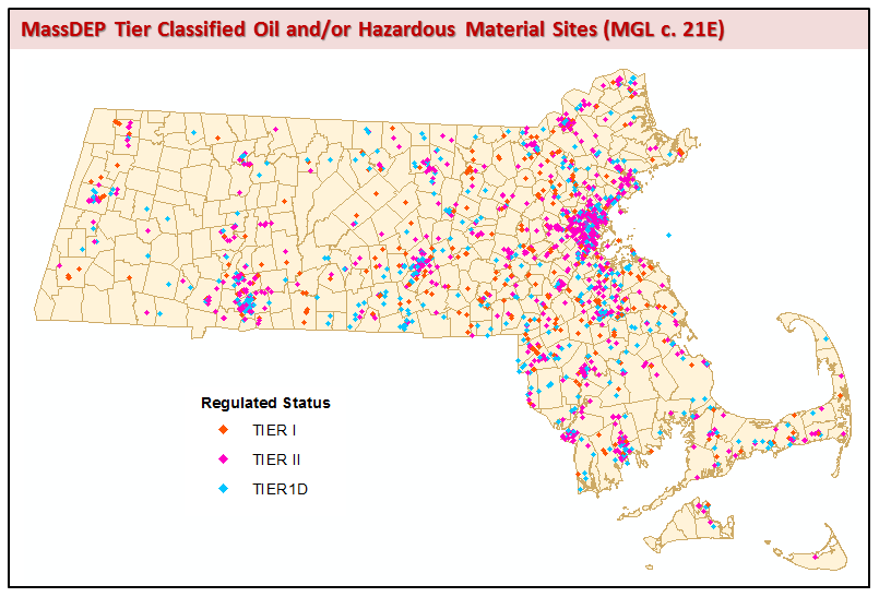
Location types featured in this datalayer include the approximate center of a site, the center of a building on the property where the release occurred, the source of contamination, or the location of an on-site monitoring well. For the purposes of this document, the terms “MassDEP Tier Classified oil and/or hazardous material disposal sites” and “Tier Classified Chapter 21E sites” are synonymous and are often referred to simply as “sites”. The layer is named C21E_PT.
Releases of oil and/or hazardous materials are reported to the Massachusetts Department of Environmental Protection’s (MassDEP) Bureau of Waste Site Cleanup (BWSC), according to procedures established in the MCP (310 CMR 40.0000). The sites mapped in this datalayer represent only a subset of the total reported Chapter 21E sites tracked by MassDEP BWSC. Chapter 21E sites that have not yet been Tier Classified are not contained in this datalayer.
Under Massachusetts’ Waste Site Cleanup Program, which is a largely privatized program, data maintained by the MassDEP regarding site location are provided to MassDEP BWSC by Responsible Parties (RP), Potentially Responsible Parties (PRPs) and by Licensed Site Professionals (LSP), hired by the RP or PRP to conduct cleanup at a site. These data have not been field-verified.
The State Superfund Law and the Massachusetts Contingency Plan (MCP)
The rules requiring notification, assessment and remediation of releases of oil and hazardous materials are codified in the Massachusetts Contingency Plan (MCP) 310 CMR 40.0000. Under the MCP and M.G.L. Chapter 21E, the PRPs are responsible for the timely assessment and cleanup of disposal sites in Massachusetts. The MassDEP BWSC is required to audit PRP response actions performed on 20% of the sites and when necessary, provides direct agency oversight of cleanup efforts.
If permanent cleanup is not achieved for a disposal site within a year of being reported to MassDEP, the site must be classified as Tier I or II based on a variety of factors, including the site’s complexity, the type of contamination, and the potential for human or environmental exposure to the contamination. In addition, some sites are automatically given a Tier I classification if they pose an imminent hazard or affect public water supplies. A site’s Tier Classification determines the level of MassDEP oversight. Tier I sites require a permit and sites, and the most complicated sites, require direct MassDEP BWSC oversight.
Data Limitations
Many of the locations in this datalayer are based on information provided by the RP, PRP or their LSP. Locations in this datalayer should ONLY be considered as an ”approximation” or “best estimate” based on the information submitted to the MassDEP BWSC. The accuracy and completeness of the information submitted has not been verified by MassDEP.
There are other Chapter 21E sites in Massachusetts that are not contained in this datalayer. For example, this datalayer does not include (1) contaminated sites that have not been reported to MassDEP or (2) sites for which a Response Action Outcome (RAO) has been submitted to MassDEP. Furthermore, not all Tier Classified Chapter 21E sites may have been located. Please refer to the associated Unlocated Sites List (C21E_PT_USL) for a current list of unmapped Tier Classified Chapter 21E sites.
Tier Classified Chapter 21E site data are extremely temporal. Although the datalayer is updated on a regular basis, it will never be complete or up-to-date. Users should refer to the Waste Site & Reportable Release search in the Energy & Environmental Affairs Data Portal for the most current information.
MassDEP recognizes that point features are not the ideal spatial model for representing contaminated areas, especially in the case of large sites or if considerable contaminant migration has occurred. Due to the limitations of the information that PRPs and LSPs are currently required to submit to MassDEP, the spatial representation of sites as point features is currently the only realistic method for generating Tier Classified Chapter 21E site data on a statewide scale.
Due to the limitations of this datalayer, the following disclaimer language will apply to any MassDEP map product containing Tier Classified 21E site data:
Data Disclaimer:
Point locations representing Tier Classified Chapter 21E sites in this datalayer have not been field-verified and should be considered approximate.
Please be advised that this datalayer is incomplete. Not all sites are mapped. Sites that are not yet reported or tier-classified are not mapped, nor are sites for which a Response Action Outcome (RAO) has been submitted to MassDEP.
Site contamination may extend well away from the point representing a site on this map. The MassDEP BWSC site files should be reviewed for the most accurate and up-to-date information about a particular site.
Questions regarding Tier Classified Chapter 21E site data on this map may be referred to the MassDEP Bureau of Waste Site Cleanup via email at bwsc.edep@mass.gov.
Attributes
Data Structure
The point attribute table for the MassDEP Tier Classified Oil and/or Hazardous Material Sites datalayer contains the following fields:
| Field | Definition |
|---|---|
| RTN | Release Tracking Number (RTN), unique site ID |
| NAME | Site name assigned by MassDEP BWSC describes the site in terms of its location use or type. |
| ADDRESS | Site address assigned by MassDEP BWSC |
| TOWN | Standard (1-351) municipality name |
| REGION | MassDEP Region code |
| STATUS | Chapter 21E compliance status according to MassDEP BWSC |
| SITE_INFO | Link to site's description web page |
Description of General Site Information Items
General site information attributes are populated using the most current MassDEP BWSC database information available at the time of update.
RTN
The Release Tracking Number (RTN), is a unique 7-digit site identifier assigned to reportable releases by MassDEP BWSC. This number is preceded by either 1,2,3 or 4 (e.g. 3-0001234) according to the MassDEP region in which the site is located (see:description of MassDEP Region ID below).
NAME
The name assigned by MassDEP BWSC that best describes the site location. The site name does NOT necessarily reflect the identity of any PRPs.
ADDRESS
The number and street that most accurately describes the site location; mile markers or similar highway designations may also be used.
STATUS (Chapter 21E Tier Classification)
Current status of the site. Chapter 21E Tier Classification is based on the requirements, standards and procedures set forth in 310 CMR 40.0500 or 40.0600.
MCP/Chapter 21E Tier Classification Definitions
-TIER I: Any disposal site which meets the following criteria at the time of Tier Classification shall be classified as Tier I:
(a) there is evidence of groundwater contamination with oil and/or hazardous material at concentrations equal to or exceeding the applicable RCGW-1 Reportable Concentration set forth in 310 CMR 40.0360, and such groundwater is located within an Interim Wellhead Protection Area, Zone II, or within 500 feet of a Private Water Supply Well;
(b) an Imminent Hazard is present;
(c) one or more remedial actions are required as part of an Immediate Response Action pursuant to 310 CMR 40.0414(2); or
(d) one or more response actions are required as part of an Immediate Response Action to eliminate or mitigate a Critical Exposure Pathway pursuant to 310 CMR 40.0414(3).
- TIER ID: (1) A disposal site shall be deemed a Tier ID ("default") disposal site if any of the following apply:
(a) an Responsible Party (RP), Potentially Responsible Party (PRP) or Other Person for such disposal site fails to submit to MassDEP one of the following by the applicable deadline in 310 CMR 40.0501:
- a Permanent Solution Statement; or
- a Tier Classification Submittal; or
(b) the person undertaking response actions is in noncompliance with M.G.L. c. 21E, 310 CMR 40.0000 or any other applicable requirement, and MassDEP reclassifies the disposal site as a Tier ID disposal site pursuant to 310 CMR 40.0583.
- TIER II: Any disposal site that is not Tier ID pursuant to 310 CMR 40.0502 or 40.0520(5) and does not meet the Tier I Criteria described at 310 CMR 40.0520(2).
Geographic Information Fields
Geographic Information Fields are populated using GIS overlay/identity functionality.
TOWN
MassGIS standard town name
REGION
The REGION field lists the MassDEP Region in which the feature is physically located. This field must be populated with one of the following numeric MassDEP Region codes:
| DEP Region Code | DEP Region – Office Location | Acronym |
|---|---|---|
| 1 | Western Region - Springfield | WERO |
| 2 | Central Region - Worcester | CERO |
| 3 | Northeast Region - Wilmington | NERO |
| 4 | Southeast Region – Lakeville | SERO |
Related Tables
- MassDEP BWSC Downloadable Sites List - This compressed file (RELEASE.ZIP) includes a database file (RELEASE.DBF) containing a record for all reportable releases tracked by the MassDEP BWSC, as well as accompanying documentation (README.DOC). MassDEP BWSC updates this file on a regular schedule. Tablular datasets in RELEASE.ZIP can be related to the AUL datalayer by the RTN. Please note that Oil and/or Hazardous Material Sites with AULs are only a subset of the total reportable releases contained in the MassDEP BWSC Downloadable Sites List.
- DEP Location Documentation Table (C21E_PT_LDT) - See MassDEP Standards for Point GIS Data.
- Unlocated Sites Table (C21E_PT_USL) – Contains a list of known, unlocated Tier Classified Oil and Hazardous Materials Sites at the time of publication.
Maintenance
The MassDEP Bureau of Waste Site Cleanup (BWSC) maintains this data (email: bwsc.edep@mass.gov).
The current data are up-to-date through August 26, 2025.
Also see the MassDEP Oil and/or Hazardous Material Sites with Activity and Use Limitations (AUL) Datalayer, which often is updated in conjunction with the 21E sites.
| Last updated: | August 26, 2025 |
|---|