Downloads
Overview
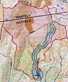
These Surface Water Supply Protection Areas delineate those areas included in 310 CMR 22.00, the Massachusetts Drinking Water Regulations, as Surface Water Supply Protection Zones:
- ZONEA: represents a) the land area between the surface water source and the upper boundary of the bank; b) the land area within a 400 foot lateral distance from the upper boundary of the bank of a Class A surface water source, as defined in 314 CMR 4.05(3)(a); and c) the land area within a 200 foot lateral distance from the upper boundary of the bank of a tributary or associated surface water body.
- ZONEB: represents the land area within one-half mile of the upper boundary of the bank of a Class A surface water source, as defined in 314 CMR 4.05(3)(a), or edge of watershed, whichever is less. Zone B always includes the land area within a 400 ft lateral distance from the upper boundary of the bank of a Class A surface water source.
- ZONEC: represents the land area not designated as Zone A or B within the watershed of a Class A surface water source, as defined in 314 CMR 4.05(3)(a).
All active and inactive surface water supplies have zones delineated, but some may be covered by other legislation. MassDEP protection Zones A, B, & C are in effect at MWRA sources and are subject to the protections in 310 CMR 22.00. MWRA has additional protections for their reservoirs that are included in the Massachusetts Watershed Protection Act, MGL 350 CMR 11.00. Watershed extents for all surface water supplies including active, inactive, emergency, sources outside of Massachusetts, watersheds that extend into other states and watersheds of sources from other states that extend into Massachusetts are included in the datalayer SWP Watersheds. Surface water intakes on Class B Rivers are not included in either datalayer. The reservoir features were taken from the datalayer and removed from the Zone A and B features and added as a separate feature. For MassDEP's regulatory wording of these zones please see Water Supply Protection Area Definitions.
This layer, named SWP_ZONES_POLY, replaces the discontinued ZONEA_POLY, ZONEB_POLY and ZONEC_POLY layers.
Production
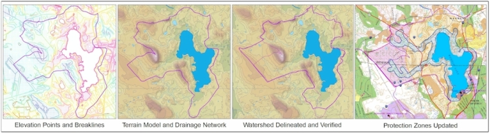
Those areas that contribute to public surface water supplies were originally taken from the USGS Drainage Sub Basins data layer and overlaid with the 1:25,000 Hydrography data layer to identify reservoirs and tributary streams. Reservoirs and tributaries were extracted and buffered to produce Zone A’s, reservoirs were extracted and buffered to produce Zone B’s, and sub basins were extracted to create Zone C’s. Starting in 2003, the DEP GIS Program began using the elevation control points and breaklines from the 1990s Aerial Imagery to create a digital elevation model of a surface water supply watershed, and using the ArcHydro Toolset developed by ESRI and the University of Texas GIS Water Resources Consortium delineated watersheds digitally. Additional streams were extracted from the data layer, added to the USGS 1:25,000 Hydrography (now enhanced by DEP) data layer and buffered to create extended Zone A’s. This work is ongoing and is about 35% complete, with watersheds prioritized by perceived accuracy or if threats to the watershed are identified, with work now progressing in Essex County. Please refer to the delineation type and date fields to see which watersheds have been processed. In addition to this, in 2007 the reservoir polygons were extracted from the DEP Wetlands 1:12000 data layer and used to modify the Zone A and B buffers and were added to the USGS 1:25000 Hydrography data layer to allow it to accurately align with the buffer zones. While many of the watersheds are based on USGS Drainage Sub Basins, no attempt has been made to align the existing sub basins with the terrain delineated watersheds and zones, including errors in major basin divides. The attributes relating to water supply zones in the existing USGS Drainage Sub Basins have been removed.
Attributes
Protection zones are unique and complete for each source and can be selected by using the item SOURCE_ID. Sources that are contained within or overlap the watersheds of other sources will have part of their Zone C removed when it coincides with the Zone A or B of the upstream source, and some sources may have no Zone C because the watershed is entirely Zone A or B. Some sources may have no reservoir because there is no impoundment or the impoundment is too small to be mapped. Discontinuous Zone C features have been combined into a single multipart polygon feature. Summary attribute information for the Zones is contained in the SWP Watersheds datalayer, and detailed information about the source is contained in the Public Water Supplies datalayer.
The attributes for each feature are:
| Item | Description |
|---|---|
| SOURCE_ID | Surface water supply source-id from the Public Water Supply datalayer |
| SWPZONE | SWP Zone Type: A – Zone A B – Zone B C – Zone C R - Reservoir |
| ACRES | Area of the Zone (ABCR) in acres |
| SITE_NAME | Site Name of the reservoir or intake, taken from the Public Water Supply datalayer |
| PWSID | Public Water Supplier ID, taken from Public Water Supplies datalayer |
| SUPPLIER | Public Water Supplier Name, taken from Public Water Supplies datalayer |
| DELINYEAR | Calendar year of delineation |
| DELINTYPE | Delineation Type: USGS SUB BASIN – from USGS Sub Basins MGIS TERRAIN – Derived digitally from terrain DEP WETLANDS – from |
| COMMENTS | Comments field |
Special Notes for ArcGIS Users
Since all of the features are contained in a single datalayer and the features contain overlapping areas, the use of the Symbol Levels feature under the advanced options dialog in the symbol editor window will ensure that the zones draw in the correct order. The preferred order is: Zone C, Zone B, Zone A, Reservoir. To do this open the Layer Properties window, choose Symbology Tab, select Categories > Unique values and use the SWPZONES attribute, symbolize the features in the preferred order, the select the Advanced > Symbol Levels tool in the lower right, order the features in the preferred order and check the box next to 'Draw this layer using the symbol levels specified below'.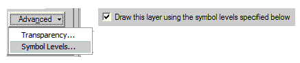
Maintenance
The Massachusetts Department of Environmental Protection (DEP) GIS Program is maintaining this datalayer. Any updates sent to MassGIS will be forwarded to DEP and incorporated into this data layer. Please reference the town, water supplier ID, water supply source ID (if known), and major basin identifier when providing updates.
May 2007 – All reservoirs extracted from the DEP Wetlands 1:12000 datalayer, buffers recreated for Zone A and B. Wenham Lake Reservoir (3030001-01S) zones updated.
July 2007 – Zones updated for all sources in Beverly, Peabody, Lynn, Danvers, Manchester, Ipswich, Gloucester and Rockport
November 2007 - watersheds and protection zones were revised for all sources in Peabody, Lynn and Beverly.
December 2008 - Added: 1114000-03S GREEN RIVER (03S); Removed: 1209000-02S BROAD BROOK (02S), 2011000-01S UPPER NAUKEG LAKE, 2332000-01S MEETINGHOUSE POND, 2343000-01S UPPER NAUKEG LAKE.
January 2009 – Zones updated for all sources in Danvers, Ipswich, Manchester, Gloucester, Rockport, Newburyport, Haverhill, Amesbury, Andover, North Andover, Wakefield, Winchester, Burlington, Concord, Leominster, Lincoln and Greenfield, and Fitchburg sources 01S, 06S and 09S. Sources in Cambridge (Waltham) and the Ware River Intake were edge matched and features added for adjacent zones newly delineated. Features were edited in Peabody, North Brookfield, and Amherst. Worcester sources and the Wachusett Reservoir watershed are included in this update as preliminary, they have not been field verified except where the watersheds adjoins Leominster and Fitchburg watersheds. In March 2009 one duplicate polygon was removed.
In March 2010 the following updates (completed in November 2009) were released: Zones were updated for all sources in Ashburnham, Gardner, Fitchburg (North), Hudson, Marlboro, Milford, Westborough, Winchendon, Cambridge, Abington, Attleboro, Braintree, Brockton, Fall River, Falmouth, Hingham, Holbrook, New Bedford, Randolph, Somerset, Taunton and Weymouth. The zones for Worcester sources and the Wachusett Reservoir were edited and are now final. The zones for Upper Naukeag Lake in Ashburnham were restored, as they were inadvertently removed from the previous version because the lake is now a source for a joint water authority between Ashburnham and Winchendon, using the existing Winchendon intake. The Ashburnham intake is now considered an emergency source until it is officially abandoned.
In April 2017 – Watersheds updated for all sources in the MassDEP Western Region (source ids start with a “1”) ( Berkshire, Franklin, Hampden and Hampshire counties) except for the Cobble Mountain Complex (source ids 1281000-02S, 1281000-05S, 1281000-07S) and the Quabbin Reservoir (source id 6000000-02S) . The watersheds for Mill Pond (Burlington Water Dept.), Old Oaken Bucket Pond (Scituate Water Division) and Silver Lake (Brockton Water Commission) (source ids 3048000-02S, 4264000-01S, 4044000-01S) were altered per staff input.
In April 2023, watersheds associated with the following sources were removed due to abandonment in the MassDEP Water Quality Testing System (WQTS): Horn Pond (3347000-01S), Bear Hole Reservoir (3347000-01S), Montgomery Reservoir (1329000-01S), Basett Brook Reservoir (1004000-01S), Highland Springs Reservoir (1004000-01S), and Kitchen Brook Reservoir (1058000-01S).
In May 2023, Zone A updates were made based on visual observations and GPS measurements made during site visits over several years by MassDEP Drinking Water Program staff. The site visits were requested by Public Water Systems, private citizens, and property owners. An accompanying update to the Hydrography (1:25k) layer is not available at this time.
Targeted updates were made to zones in the watersheds of the following surface water sources:
- MT Street Reservoir, PWS Source ID 1214000-01S, Northampton Water Dept.
- Cobble Mountain, PWS Source ID 1281000-02S, Springfield Water & Sewer Commission
- Fitchburg Reservoir, PWS Source ID 2097000-11S, Fitchburg DPW, Div. of Water Supply
- Quinapoxet Reservoir, PWS Source ID 2348000-05S, Worcester DPW, Water Supply Division
- Lake Attitash, PWS Source ID 3007000-02S, Amesbury DPW Water Division
- Wenham Lake, PWS Source ID 3030001-01S, Salem-Beverly Water Supply Board
- Mill Pond Reservoir, PWS Source ID 3048000-02S, Burlington Water Dept.
- Stony Brook Reservoir, PWS Source ID 3049000-03S, Cambridge Water Department
- Babson Reservoir, PWS Source ID 3107000-01S, Gloucester DPW Water Department
- Hawkes Pond, PWS Source ID 3163000-02S, Lynn Water & Sewer Commission
- Hingham Street Reservoir, PWS Source ID 4001000-02S, Abington/Rockland Joint Water Works
- Orrs Pond, PWS Source ID 4016000-04S, Attleboro Water Dept.
- Wading River, PWS Source ID 4016000-05S, Attleboro Water Dept.
- Assawompset Pond, PWS Source ID 4293000-01S, New Bedford Dept. of Public Infrastructure
- Assawompset Pond, PWS Source ID 4201000-03S, New Bedford Dept. of Public Infrastructure
- Somerset Reservoir, PWS Source ID 4273000-01S, Somerset Water Department
- Old Swamp River, PWS Source ID 4336000-02S, Weymouth Water Department
- Wachusett Reservoir, PWS Source ID 6000000-01S, MWRA
- Ware River Intake, PWS Source ID 6000000-06S, MWRA
- Manhan Reservoir (05S), PWS Source ID 1137000-05S, Holyoke Water Works
Data Disclaimer
The zone protection areas delineated here were done using the best available methods and data at the time of their creation. No subsurface water movement of any kind was used in the delineation process. Actual conditions may be different from the delineations shown in this data layer. There may be local bylaws or data that indicate that contributing areas shown here are actually not contributing areas in the drinking water reservoir watershed. If you feel any of this data is in error, please contact the MassDEP Drinking Water Program at: program.director-dwp@mass.gov Subject: DWP/Technical Services. If you have any questions about Zone A delineations or to request a review of an existing Zone A, please provide any data to support your claim, preferably in digital form.