Downloads
Overview
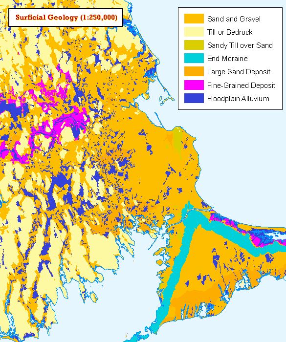
MassGIS has produced a statewide surficial geology datalayer showing the location of sand and gravel deposits. Originally the data were divided into three panels- west, east, and southeast that correspond to the U.S. Geological Survey 1:250,000 map sheets that were used as a basemap. This datalayer is very generalized when compared to the other MassGIS data. MassGIS uses the surficial geology data only to produce volume or area measurements over a large region, e.g. a drainage basin. It is not accurate for site specific analysis.
As part of a major data development effort, the datalayer has been greatly enhanced. The data include areas of fine-grained deposits and floodplains. For the original southeast panel, the 1:250,000 Providence, RI sheet, large sand deposits have also been delineated. Additionally, contour lines indicating depth of sand and gravel deposits have also been added.
The layer is named SURFGEO250K_POLY.
Production
Manuscript
This datalayer was interpreted and compiled by Byron Stone, a USGS geologist. A set of USGS 1:250,000 film basemaps were enlarged onto stable based film at a scale of 1:125,000. The data were then recompiled from a set of 1:25,000 quadrangle sheets onto the 1:125,000 basemap. This manuscript does not precisely register with the standard MassGIS basemap.
Methodology
For the original datalayer production, the tics of the Transverse Mercator manuscripts were projected into the MassGIS State Plane coordinates before digitizing began. Polygons were labeled and a checkplot was made at manuscript scale.The enhancement, also interpreted and compiled by Byron Stone, was completed in the fall of 1992. With the enlarged maps as basemaps, the fine-grained deposits, floodplains and contours were drafted onto film. All digitizing was completed by MassGIS from these overlays and subsequently, the linework was transformed and projected into state plane coordinates. As with the original manuscripts, these overlays do not precisely register with the MassGIS basemap. Plots were made at a scale of 1:125,000 and compared to the original manuscripts. The coverages were clipped to the 1:100,000 coastline.
In October 1999 this layer was moved from the BASIN library to WATRSHD2 when MassGIS received additional data from Pete Steeves of the USGS office in Northborough, Mass., which completed the entire extent of all watersheds that cover Massachusetts. At the same time the layer was edited to remove old county lines that remained from a previous tiling scheme.
Attributes
The layer's polygon attribute table has the following items:
| Field name | Description |
|---|---|
| CODE | 1 - sand and gravel deposits 2 - till or bedrock 3 - sandy till over sand 4 - end moraines 5 - large sand deposits where distinguished from sand and gravel deposits 6 - fine-grained deposits 7 - floodplain alluvium |
| AREA_ACRES | Area of the polygon in acres |
| RANGE | Range of depth of deposit in feet for code = 1 or 5 in Massachusetts |
Maintenance
MassGIS is managing this datalayer. No updates are planned. Also see the layer Surficial Geology (1:24,000).