MaGICC December Meeting
The Massachusetts Geospatial Information Coordinating Council (MaGICC) met on December 10, 2025. This was the Council’s third meeting. MaGICC is focused on policy issues to guide the Commonwealth’s geospatial ecosystem, often referred to as the Massachusetts Spatial Data Infrastructure (MSDI). At this meeting, the Council discussed a draft policy statement on MSDI governance.
This draft policy statement will define a recommended policy on collaborative governance for the Commonwealth’s shared geospatial ecosystem. This collaborative governance will help all organizations better the activities we need to accomplish, which are often supported by a shared spatial data infrastructure. MSDI governance involves all the stakeholder sectors in making collaborative decisions about how the MSDI is managed and sustained. The Council had a discussion on governance and is making a few edits to the governance policy statement before it is finalized.
At this meeting, the Council also undertook a discussion on Data Stewardship. Data stewardship policy is an important aspect of a shared asset like the MSDI, which is managed collectively by many stakeholders across multiple sectors, including government, private sector, non-profit and higher education. Geospatial data are expensive to create and maintain, as well as to form into datasets of documented quality, accuracy, currency, and completeness. Well managed stewardship practices reduce data duplication and prevent periodic data re-collection and redevelopment by multiple organizations.
Stewardship means having a single organization take on the role of data steward for a shared data set, ensuring that data from various sources is regularly ingested to maintain the data set on behalf of the enterprise, which includes all geospatial data users across the Commonwealth. That would create a certainty that would enable others to expend resources on applications that rely on that data, rather than many organizations collecting the data only for their own purposes.
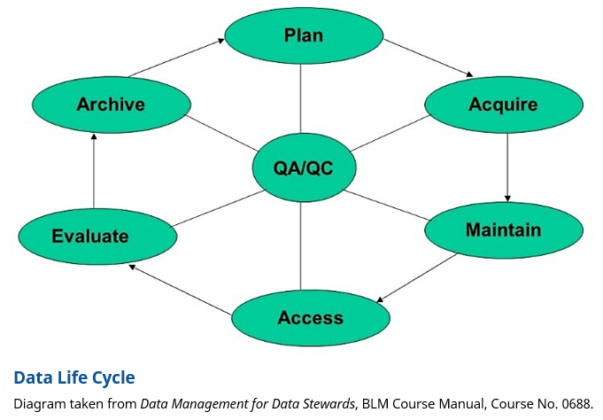
Stewardship for the entire data life cycle, as shown in the data life cycle diagram below, would ultimately be the responsibility of a single organization for a particular data set or data theme (e.g., parcels, roads, addresses, trails, etc.). But there may be many organizations involved in the various aspects of the data life cycle, all coordinated by the data steward for that data set or data theme. The Council is working on a data stewardship policy statement for review and discussion at its next meeting in March 2026.
Sexual Assault, Domestic Violence, and Human Trafficking Resource Viewer
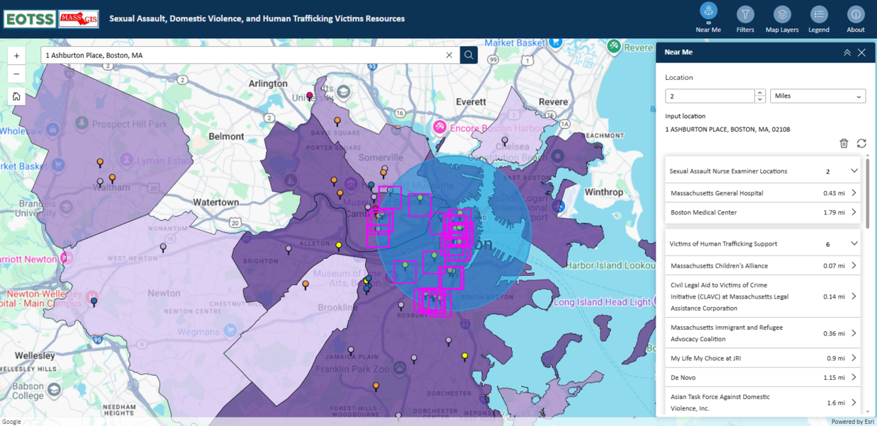
MassGIS, in collaboration with the Governor’s Council to Address Sexual Assault and Domestic Violence, recently completed an upgrade of the Sexual Assault, Domestic Violence, and Human Trafficking Victims Resources application. This application helps users across the Commonwealth find resources for victims of sexual assault and domestic violence, and there is a new layer for human trafficking victims as well. The 'Near Me' widget within the application allows users to type in their address and find all resources within a specified radius. The resources mapped include rape crisis centers, sexual assault nurse examiners (SANE) locations, victims of human trafficking support, general shelters, district attorney’s offices, and crisis housing facilities. Users who seek a specific type of shelter can utilize the 'Filters' widget to filter locations within the General Shelters and Housing Facilities layers. Designed to be accessible and easy to navigate, this application provides users with a quick way to find resources near them during a time of crisis.
Redeveloping the application in Esri’s new Experience Builder system in ArcGIS opened the door for MassGIS to expand its accessibility and capabilities. Experience Builder provides templates optimized for numerous screen sizes, from desktop monitors to tablets to mobile phones. MassGIS focused on the mobile version of the application to improve accessibility in the modern day. The Governor’s Council to Address Sexual Assault and Domestic Violence requested with the highest priority that the application be compatible with mobile devices. They emphasized that most users of this application would access the internet on their mobile devices, particularly during crises. This new mobile compatibility is only possible within Experience Builder. With the deprecation of the old Web AppBuilder system, it was imperative to migrate the application to Experience Builder to ensure it remains compatible with any browser and inherits security updates for the foreseeable future, protecting users and their access to this crucial application.
MassGIS is proud to have been given the opportunity to develop this application and will continue to ensure its accessibility to all users across the Commonwealth.
New England 3D Hydrography Program Grant Accepted
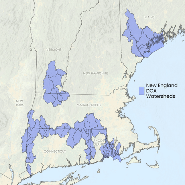
MassGIS is excited to announce that the U.S. Geological Survey (USGS) has approved funding for the 3D Hydrography Program (3DHP) grant request covering several New England regional hydrologic units (HUCs) that cross state boundaries. This initiative will advance the development of elevation-derived hydrography across watersheds in Connecticut, Massachusetts, Maine, New Hampshire, New York, Rhode Island, and Vermont.
This milestone reflects a sustained regional effort. In June 2024, Connecticut, Rhode Island, Massachusetts, Vermont, and Maine worked together to submit a joint Data Collaboration Announcement (DCA) application under the USGS 3DHP program, aiming to map cross-border hydrologic units. While that initial proposal generated enthusiasm, it was not funded due to budget and timing constraints. In 2025, the collaboration expanded to include New York and New Hampshire, with work proposed across all seven states. Together, this group submitted a new application, which has now been approved!
Recognizing that watersheds often cross political boundaries, this project emphasizes the importance of interstate collaboration and the value of high-quality hydrographic data, with a focus on developing data in watersheds that span multiple states. The group’s motto is: political boundaries are immaterial to the flow of water. This regional work enhances and extends the work MassGIS and the Massachusetts Hydrography Framework Implementation Committee are doing to improve hydrography data across the Commonwealth.
The 3DHP is a national initiative to modernize surface water mapping by creating high-resolution, elevation-derived hydrography that integrates seamlessly with lidar-derived elevation data as part of the 3D National Topography Model. The grant approval enables us to move into coordinated planning and stakeholder engagement to support the development of improved hydrography data. Work on the New England regional effort will begin soon, and we look forward to continuing this process with USGS, our partner states, and the selected vendors.
2025 GIS Management Survey
The Geospatial Professional Network (formerly URISA) needs your participation in its GIS Management survey. The survey focuses on project management approaches of a variety of GIS organizations, including the public, private, university, and non-profit sectors. The summary report, which will be FREE to all survey participants, will have an analysis of the current GIS Management practices and trends.
You do not need to be a Geospatial Professional Network member to participate. The completion time is between 20 and 45 minutes. The deadline is February 16th.

Data Updates
- Public Utility Service Providers
January 14, 2025 - Update based on data from the Massachusetts Department of Public Utilities from October 2025 and the Massachusetts Department of Telecommunications and Cable from January 2026. - Property Tax Parcels
December 24, 2025 - 19 municipalities: Bellingham, Berkley, Bolton, Boxford, Bridgewater, Cambridge, Charlton, Lancaster, Leominster, Newton, Orleans, Peabody, Plymouth, Princeton, Sterling, Ware, West Brookfield, Whately, and Wrentham. - Schools (Pre-K through High School)
December 19, 2025 - Update based on the Massachusetts Department of Elementary and Secondary Education (DESE) school profiles database as of November 5, 2025. - MHC Historic Inventory
December 10, 2025 - Massachusetts Historical Commission staff have completed a significant update to the towns of Boston, Eastham, Fall River, Lincoln, Marblehead, Mattapoisett, Medford, Monson, Nantucket, Swampscott, Watertown, Wellfleet, Westminster, Winchester, and Whitman, reviewed and corrected data for some of the first towns to be digitized: Blackstone and Mattapoisett, and updates are in progress for Andover, Attleboro, Bridgewater, Middleborough, New Bedford, and Westport. - MassDEP Estimated Sewer System Service Area Boundaries
December 16, 2025 - Updates to this dataset that represents approximate service areas for sewer systems operated by publicly owned treatment works (POTWs), sewer districts and non-POTW systems. - Protected and Recreational Open Space
November 6, 2025 - Executive Office of Energy and Environmental Affairs GIS staff have updated the Protected and Recreational OpenSpace layers (arcs and polygons), available from MassGIS. Since the last publication to the web, staff at EEA and its associated agencies performed edits that improved the boundaries and/or descriptive geography to over 3,900 polygons in 160 municipalities, resulting in a net gain of over 6,600 acres.
Shapefile and file geodatabase downloads represent data updated as of 10/14/2025.
The details:- Added or improved the boundaries and attributes of many types of recreational areas and open spaces with various levels of protection: 134 conservation areas, 17 water supply lands (both state and local)/watershed restrictions, 30 agricultural preservation restrictions (all types)/community gardens, 66 parks/beaches/rail trails and 55 conservation restrictions/easements.
- EEA additionally updated the database with numerous EEA-sponsored programs: 2 Conservation Land Tax Credits, 13 Parkland Acquisitions and Renovations for Communities (PARC) grants, 6 Landscape Partnership grants, 1 Forest Reserve grant, 8 Conservation Partnership grants, 4 Cranberry Bog Acquisition for Restoration grants, 2 Drinking Water Supply Protection grants and 3 Local Acquisitions for Natural Diversity (LAND) grants.
- Trains
October 31, 2025 - Updated the MBTA Commuter Rail point and line data to reflect the opening of the South Coast Rail route and made other spatial and attribute edits.
Events and Announcements
Register - OpenStreetMap Mapping USA 2026 free virtual conference, Jan 30-31
Save the Date - Spring 2026 NEARC Conference, May 26 at UMass Amherst
Register - 2026 State of the Map Conference, June 11-13 in Madison, Wisc.
Contact
Online
Address
| Date published: | January 22, 2026 |
|---|