

June MaGICC Meeting
The Massachusetts Geospatial Information Coordinating Council (MaGICC) met on June 10, 2026, for its fifth meeting. The Council is focused on developing policies that guide the Commonwealth's geospatial ecosystem, known as the Massachusetts Spatial Data Infrastructure (MSDI). During the meeting, members discussed a draft policy statement on MSDI data sharing and began developing a geospatial standardization and maintenance policy.
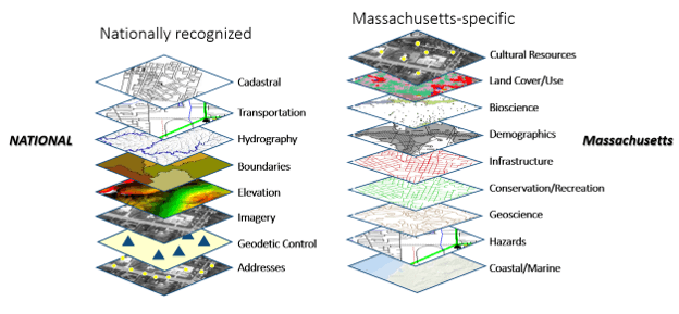
The draft data sharing policy is intended to protect and maximize the Commonwealth's investment in Framework geospatial data, which is organized into the 17 data themes shown below. By promoting consistent data sharing practices, the policy aims to reduce duplicate data development across the public and private sectors while improving the quality, accessibility, and availability of geospatial data for planning and decision-making.
The proposed policy promotes the FAIR data principles (Findable, Accessible, Interoperable, and Reusable) and emphasizes the importance of complete metadata and documentation so data can be effectively used by both people and machine learning systems. Data should be open and unrestricted by default. However, when privacy or security concerns exist, appropriate data sharing agreements and access controls should be implemented.
The policy also recommends that data and map services comply with WCAG 2.1 and 2.2 AA accessibility standards, use common file formats, and include georeferenced data that can be integrated with other datasets. To support emergency management and public safety, critical data should be readily available to partners before emergency, security, and hazard events.
The Council also unveiled the new MaGICC Hub site and discussed a MassGIS initiative to strengthen the ability of Regional Planning Agencies (RPAs) to provide geospatial data and technology support to municipalities.
The MaGICC Hub is a public resource for Council policy statements, meeting information, and StoryMaps that summarize past meetings and include presentations and supporting documents. The site also lists Council members and the sectors they represent, including state, local, regional, nonprofit, higher education, and private organizations.
Many municipalities face challenges creating and maintaining the standardized geospatial data needed for emergency planning and response, infrastructure management, social service delivery, economic development, and other essential functions. This information forms a critical part of the Massachusetts Spatial Data Infrastructure.
To help address these challenges, MassGIS is supporting the development of a collaborative municipal GIS support model involving six RPAs, led by the Merrimack Valley Planning Commission (MVPC) and funded through capital appropriations. The initiative will expand to include six additional RPAs in FY27. Initial efforts focus on parcel and address data and will later expand to additional datasets that are wholly or partially derived from municipalities. Many participating RPAs already maintain data pipelines for key MSDI datasets and are well positioned to expand that role.
The next MaGICC meeting will be held in person in Westborough on September 16.
Notify911 Address Finder Now Available Statewide
In the previous issue of The GISette, we introduced Notify911 Address Finder, a new MassGIS application designed to improve address quality and ensure addresses are accurately represented in Massachusetts' Next Generation 911 (NG911) system. We are excited to announce that the application is now available statewide for municipalities, regional agencies, utilities, GIS professionals, emergency communications personnel, and members of the public. You can access the application here: NG911 Address Finder.
Before its statewide release, Notify911 Address Finder was piloted in the Town of Natick. MassGIS thanks Sgt. Jason Sutherland and the many municipal staff members who contributed their time, expertise, and feedback throughout the pilot. Their participation helped refine the application's functionality and improve the user experience for users across the Commonwealth.
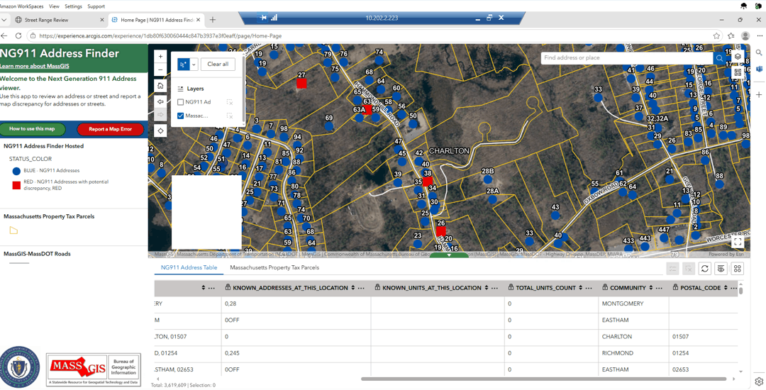
Notify911 Address Finder allows users to search for and validate addresses against the authoritative address data used to support NG911. The application helps users confirm that an address is represented correctly and identify potential errors or missing information.
A key feature of Notify911 Address Finder is its ability to collect user feedback. When an address appears incomplete or incorrect, often displayed as red squares in the application (see the screenshot below), users can report the issue by selecting the red Report a Map Error button. A survey will open where users can provide information about the issue. For example, if a resident sees records for Units 5 and B but knows that Unit B does not exist and Units 2, 3, and 4 are missing, they can report the discrepancy through the survey.
Resolution times may vary. MassGIS will review each report and confirm updates with municipal staff. Some edits may require additional coordination before changes can be made.
We encourage residents, property owners, municipal staff, and anyone with local knowledge to submit feedback. Their contributions will help resolve remaining issues in the statewide address database and improve its accuracy as communities continue to grow and change.
If you have questions or would like more information, please contact MassGIS at Notify911Address@mass.gov.
Interactive Property Map - New and Improved
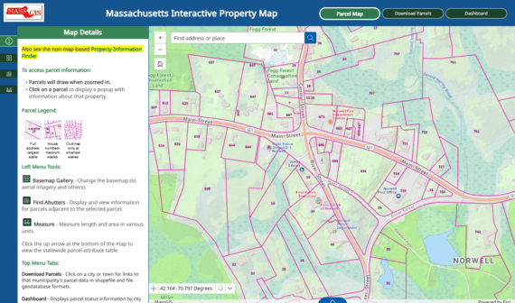
MassGIS is pleased to announce the availability of the new Massachusetts Interactive Property Map. Built with Esri's Experience Builder, the application features the popular statewide assessor parcel map and includes additional tabs for downloading municipal parcel data and viewing the parcel status dashboard.
New features include an Abutters Tool that highlights parcels adjacent to a selected property and displays information about those neighboring parcels. Parcel popups now include use code descriptions, making it easier for users to interpret parcel data. The application is optimized for desktop, tablet, and mobile devices.
MassGIS Interns
As the Communications Lead for the MassGIS intern team, Sadie Kriegler is helping to strengthen MassGIS's connections with its partners and the broader GIS community. Her primary focus is modernizing the office's communications infrastructure by organizing and improving its contacts database and supporting the relaunch of key communication channels. One of Sadie's main projects is developing a centralized, well-organized contacts database that will make it easier for staff to maintain accurate stakeholder information and coordinate outreach efforts. By streamlining contact management, the project will improve efficiency, reduce duplication, and provide a stronger foundation for future engagement with agencies, municipalities, academic partners, and other members of the Massachusetts GIS community. In addition to this work, Sadie is helping revitalize MassGIS communication channels, including newsletters and other outreach efforts, to ensure that important updates, projects, and resources are shared more effectively. Her goal is to help establish consistent communication practices that make it easier for stakeholders to stay informed about MassGIS initiatives and the valuable geospatial services the office provides. Through these efforts, Sadie is supporting MassGIS's mission to foster collaboration, improve transparency, and strengthen relationships across the Commonwealth. By building sustainable systems for communication and outreach, she is helping position the office to better serve its partners and the public well into the future.
Promise Peralta is the GIS Intern for the MassGIS 911 Team. During her time in the position thus far, she has focused on the Street Address Range Improvement Project. The goal of the project is to develop publicly distributable statewide street datasets for the Commonwealth. This project is taking data from the Master Address Database (MAD), including address points and parcel information, to generate a resource that can be maintained and shared freely. Her primary responsibilities include reviewing and validating address range recommendations generated through GIS analysis and Python-based automation. By comparing recommended ranges with existing street centerline data, she helps ensure that address ranges accurately represent addressing patterns while maintaining geographic flow. Along with the 911 Street Range Editing, she is working on an Addresses to Possibly Move Project, which focuses on parcel and address verification. This process includes reviewing discrepancies between parcel data and address points of identified locations. Using Google Street View, she evaluates whether addresses are correctly associated with their corresponding parcel. From there, she documents her findings by providing the correct parcel association and making notes for the location. Throughout her internship, Promise has gained practical experience in spatial data analysis and geospatial quality assurance while working with large statewide datasets. As she continues to contribute to these projects, her work improves the accuracy and reliability of data that is used for emergency response. By helping to develop and verify this data, she is contributing to resources that the public can freely access and use.

Data Updates
- VA Centers
July 7, 2026 - New datalayer of Veterans Affairs (VA) centers within the Commonwealth.
- VA Healthcare
July 7, 2026 - New datalayer of Veterans Affairs (VA) healthcare providers within the Commonwealth.
- MBTA Communities (3A) District Atlas
July 6, 2026 - This collection of data layers, published in May 2026, contains parcel, district, and municipal-level information submitted by municipalities to demonstrate compliance with the MBTA Communities law (also known as Section 3A of the Zoning Act). The July update adds data for Hopkinton and West Bridgewater.
- Property Tax Parcels
June 2026 - 31 municipalities: Avon, Bernardston, Buckland, Dighton, Fitchburg, Granby, Harwich, Leicester, Leverett, Littleton, Ludlow, Malden, Monterey, Nantucket, Norfolk, North Andover, North Reading, Oak Bluffs, Sandwich, Shelburne, Shirley, Shutesbury, Spencer, Stockbridge, Stoughton, Stow, Walpole, Westborough, and Winthrop.
NOTE: As of the April 2026 update, MassGIS will begin replacing all .lyr files with .lyrx files in both the shapefile and file geodatabase downloads of municipal parcel data. ArcGIS Pro users will be able to use both, but ArcMap users will not be able to access the new .lyrx files.
- MHC Historic Inventory
June 4, 2026 - Massachusetts Historical Commission staff have completed a significant update to the towns of Boston, Holliston, Manchester, and Mattapoisett, reviewed and corrected data for some of the first towns to be digitized: Blackstone and Mattapoisett, and updates are in progress for Andover, Attleboro, Bridgewater, Middleborough, New Bedford, and Westport.
- Hurricane Evacuation Zones
May 22, 2026 - Now available from MassGIS is this layer that represents areas that may be inundated by storm surge or isolated by storm surge waters. As a hurricane approaches, local or state officials may order evacuations of these areas.
- Building Structures
May 21, 2026 - Updated with edits compiled atop MassGIS' spring 2025 imagery across the state (except Boston).
- Colleges and Universities
May 20, 2026 - Update based on data downloaded from the National Center for Education Statistics (as of May 14, 2026) and data sent by the Massachusetts Office of Consumer Affairs and Business Regulation Division of Professional Licensure (last updated in August 2023).
- Master Address Data Statewide Points for Geocoding
May 12, 2026 - Address locators available for ArcGIS Pro. When users request the data, the confirmation email will include links to the files.
Events and Announcements
- Save the Date - GPN - NE Conference - September 18 in Bridgewater, MA.
- Save the Date - FOSS4G 2026 - November 2-4 in Sacramento, CA (Free and Open Source Software For Geospatial)
- Save the Date - 2026 Fall NEARC Conference - November 15-18 in Portland, ME
Contact
Online
Address
| Date published: | July 23, 2026 |
|---|