Overview
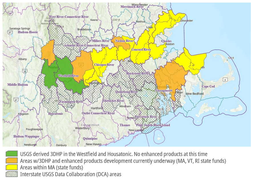
MassGIS has been working with all the other New England states to update our surface water data across the region. There are a number of New England regional hydrologic units (HUCs) that cross state boundaries, as well as many more watersheds that exist wholly within each state. This initiative will advance the development of elevation-derived hydrography across all watersheds in Connecticut, Massachusetts, Maine, New Hampshire, New York, Rhode Island, and Vermont.
This collaborative work reflects a sustained regional effort. In June 2024, Connecticut, Rhode Island, Massachusetts, Vermont, and Maine worked together to submit a joint Data Collaboration Announcement (DCA) application under the USGS 3DHP program, aiming to map cross-border hydrologic units. While that initial proposal generated enthusiasm, it was not funded due to budget and timing constraints. In 2025, the collaboration expanded to include watersheds that cross our state boundary with New York and New Hampshire. Together, this group submitted a new grant application, which was approved for the FFY26 budget cycle. Paperwork to make that award and initiate the cross-border work is now underway.
Recognizing that watersheds often cross political boundaries, this project emphasizes the importance of interstate collaboration and the value of high-quality hydrographic data, with a focus on developing data in watersheds that span multiple states. The group’s motto is: political boundaries are immaterial to the flow of water. This regional work enhances and extends the work MassGIS and the Massachusetts Hydrography Framework Implementation Committee are doing to improve hydrography data across the Commonwealth.
The 3DHP is a national initiative to modernize surface water mapping by creating high-resolution, elevation-derived hydrography that integrates seamlessly with lidar-derived elevation data as part of the 3DNational Topography Model. The grant approval enables us to move into coordinated planning and stakeholder engagement to support the development of improved hydrography data. Work on the New England regional effort will begin soon, and we look forward to continuing this process with USGS, our partner states, and the selected vendors.
As a significant part of this collaborative work, all the states are working to develop additional enhancements, with the 3DHP data as the foundation. Those enhancements include local stormwater infrastructure data, wetlands data, and delineation of the top of the bank for all streams and rivers. This additional data will enable us to model the full hydrographic lifecycle. Among the many uses of that modeling, it:
- enables use of the data to predict and mitigate flooding and other economic risks;
- improve water flow modeling as part of planning for and designing stormwater infrastructure by contractors working for cities and towns across the Commonwealth; and,
- protect public water supplies
| Date published: | March 24, 2026 |
|---|