Towns Affected by the WsPA
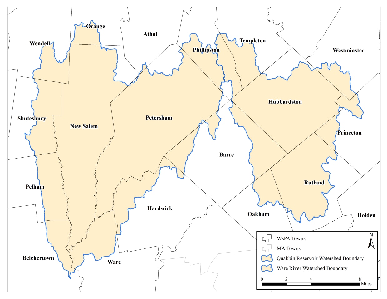
Quabbin Reservoir and Ware River Watershed Communities
These Quabbin Reservoir and Ware River watershed communities have properties regulated by the WsPA: Athol, Barre, Belchertown, Hardwick, Hubbardston, New Salem, Oakham, Orange, Pelham, Petersham, Phillipston, Rutland, Shutesbury, Templeton, Ware, Wendell, and Westminster.
WsPA information, contact:
Quabbin/Ware Region
485 Ware Rd.
Belchertown, MA 01007
(413) 213-7935
allan.rantala@mass.gov
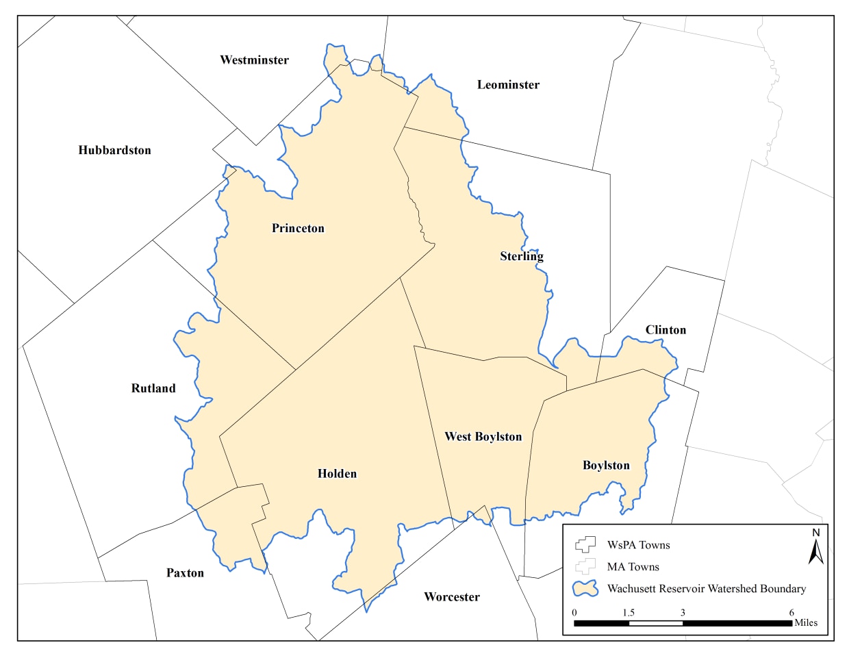
Wachusett Reservoir Watershed Communities
These Wachusett Reservoir watershed communities have properties regulated by the WsPA: Boylston, Clinton, Holden, Leominster, Paxton, Princeton, Sterling, West Boylston, and Worcester.
For WsPA information, contact:
DCR Division of Water Supply Protection
Wachusett/Sudbury Region
180 Beaman St.
West Boylston, MA 01583
(857) 303-5427
Bernadette.DeBlander2@mass.gov
Basic WsPA Information
Land use and development can affect the quality of nearby streams, which then flow into reservoirs and other sources of water supply. The amount and types of pollutants entering a steam vary based on the:
- Type of development
- Density
- Amount of paved surface
- Proximity to a stream
Often it is desirable to preserve a buffer zone beside open water, or limit impervious surface over an aquifer. Physical conditions on the land, however, may allow for different rules due to particular settings.
Protection Zones and Restrictions
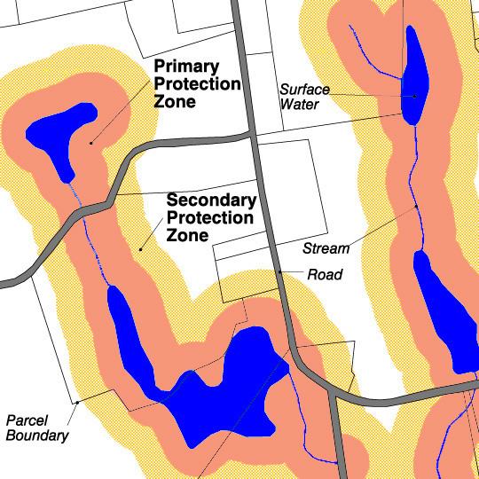
Two areas are protected in different ways under the WsPA.
Within 400 feet of the reservoirs and 200 feet of tributaries and surface waters (the "Primary Protection Zone"), any alteration is prohibited (313 CMR 11.04(3)(a)) . "Alteration" includes a variety of activities, such as:
- Construction
- Excavation
- Grading
- Paving
- Dumping
Generation, storage, disposal, or discharge of pollutants is also prohibited in the Primary Zone.
Between 200 and 400 feet of tributaries and surface waters, and on land within flood plains, over some aquifers, and within bordering vegetated wetlands (the "Secondary Protection Zone"), certain activities are specifically prohibited. These include:
- Storage, disposal or use of toxic, hazardous, and certain other materials
- Alteration of bordering vegetated wetlands
- More dense development
- Thresholds regarding impervious surfaces and septic systems
- Other activities as specified in 313 CMR 11.04(3)(b)2
WsPA Regulations and Exemptions
WsPA Regulations
The Watershed Protection Act regulations are 313 CMR 11.00. These regulations were updated in February 2017, including changing the reference number, which used to be 350 CMR 11.00.
The law was passed by the Massachusetts legislature under Chapter 36 of the Acts of 1992. The general law can be found at MGL chapter 92A 1/2.
Exemptions
There are a number of exemptions to the restrictions under WsPA. The most common are:
- Uses, structures and facilities lawfully existing as of July 1, 1992.
- Construction of a single-family dwelling on an existing vacant lot.
- Minor changes to an existing structure.
- Division of an existing owner-occupied parcel to create one additional building lot.
Please go to the regulations, under 313 CMR 11.05, to see the full list of exemptions.
Additional criteria may be required to obtain an exemption. Please contact DCR to confirm an exemption.
Additional Resources
WsPA Applications and Forms
There are several ways to communicate with DCR about projects on your property. You can obtain an Advisory Ruling by sending a letter describing your proposal to DCR. The Watershed Protection Act, however, requires specific applications for a Determination of Applicability, Variance, and Exemption of a Tributary. Applications are available below or by contacting the appropriate Division of Water Supply Protection office.
Guidance Document for Making Applications Under the Watershed Protection Act provides detailed information about filing these applications with DCR.
Please note that if you don’t own the property then you will need authorization from the owner allowing you to submit a request for DCR's review of the proposed work.
Advisory Ruling
This type of application gives an informal indication of whether the WsPA applies to the proposed activity. To apply for an Advisory Ruling, send a letter to one of the DCR addresses and include:
- Description of work proposed
- Copy of the assessor's map (or sheet and parcel number)
- Copy of the deed showing ownership
- Copy of plans or surveys, if available
- Other relevant information
An advisory ruling usually takes a few days to a few weeks, unless the project is complicated and warrants further review.
Determination of Applicability
This application is to determine whether WsPA applies to the proposed activity, or if the activity might be exempt or otherwise not prohibited. It yields a formal determination, with a 60-day time limit for an answer, which may be recorded at the local Registry of Deeds.
Variance
A landowner can apply for a Variance from the WsPA if a project does apply but they can demonstrate that the proposed activity will not impair water quality. There are specific timing components to a Variance application, including a public hearing. Any proposal for work in the "Primary Protection Zone" or in a Bordering Vegetated Wetland - other than a single family house - must also file an Environmental Notification Form with MEPA. Variance decisions are recorded at the registry of deeds.
Exemption of a Tributary
A landowner, state agency, or town can apply for this exemption if they believe a tributary, or portion of one, can be exempted from the WsPA regulations with no significant risk to water quality.
WsPA Data Viewer and List of Affected Parcels
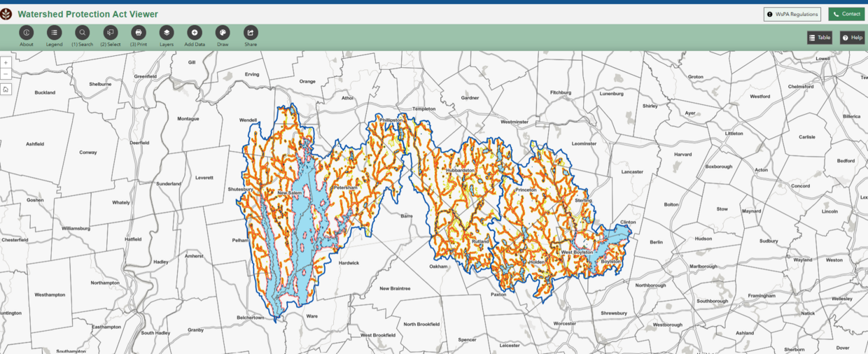
This on-line map allows you to look-up an address in the watershed system and view WsPA regulated areas. The software to display the information was updated in October 2023.
Please be aware that if there is a discrepancy between the location of a tributary on the map and its location in the field, the field location will be used. Also, not all Bordering Vegetated Wetlands are shown; the extent of BVWs is determined by each community's Conservation Commission.
Landowner's are responsible for meeting the WsPA regulations. Anyone proposing a project in the watershed system is encouraged to contact DCR to ensure the correct interpretation of the law.
You may also look up properties by town and assessor's parcel number in the Watershed Protection Act List of Affected Parcels.
Landscaping and the Watershed Protection Act
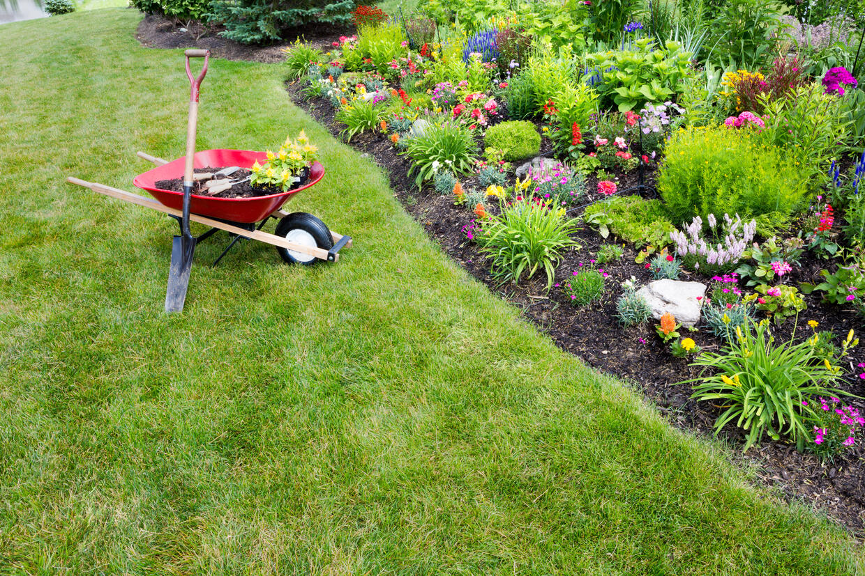
Many home landscaping activities fall under the definition of “alteration” for the WsPA. Clearing of existing vegetation; stump removal; excavation; filling; grading or other changing of topography; installation of irrigation systems; creation of pathways, patios, and retaining walls; grass seeding; and associated plantingswould all be prohibited by the Act in the Primary Protection Zone, except that the regulations also provide exemptions.
These exemptions, stated in 313 CMR 11.05 (1-3), allow property owners to landscape their homes. If a landscaping project meets the parameters described under the three exemptions that follow, then it is not necessary to contact DCR. However, any landscaping more extensive than that detailed on this web page may require a WsPA variance. Proponents of a project that entails extensive landscaping in the WsPA Primary Protection Zone are encouraged to discuss their plans with DCR/DWSP. DCR/DWSP can then determine the extent that the proposed work meets these exemption requirements, considering all factors that may affect water quality.
Landscaping, as described above, is not prohibited within the Secondary Protection Zone.
Exemption 11.05(1): Uses, Structures or Facilities in Existence
This exemption covers the maintenance of landscaping elements associated with uses, structures, or facilities that existed as of July 1, 1992. Limited expansions may be allowed as part of the pre-existing residential use of the property. The following activities, if taking place in already disturbed areas greater than 50 feet from the stream, pond or lake are exempt:
- replacing a lawn
- planting bushes
- planting trees
- installation of decorative walls
- planting gardens
- limited re-grading
- establishing ground cover
- installation of paths
A modest expansion of landscaping beyond the already disturbed area of the lot may be allowed under this exemption, but not within 50 feet of the resource. Any increases in impervious areas may require a variance.
Please contact DWSP directly if you intend to install a fence or a pool.
Exemption 11.05(2): Reconstruction, Extension or Structural Change
This exemption allows a property owner to make repairs or alterations on “structures,” including fences, pathways, pools, and retaining walls. Substantial change or enlargement is not permitted.
Exemption 11.05(3): Lot in Existence
This exemption is for the construction of one single-family dwelling on an existing lot (as of July 1, 1992). Landscaping necessary for driveway and parking areas, wells, septic systems, lawns, and gardens are all components of a new home that would be exempt.
The exemption stipulates, however, that “wherever possible” there shall be no Alterations within the Primary Protection Zone. Given the constraints of a particular lot, all or part of the construction may have to occur within this zone. If landscaping is required in the Primary Protection Zone, the activities are exempt only to the extent necessary to reasonably support the dwelling. Construction activities usually disturb an area approximately 30 feet out from the foundation. An expansion up to 50 feet from the foundation, or slightly greater distance in order to accommodate a septic system leaching field, would be considered reasonable, provided such landscaping did not encroach to within 50 feet of the Bank of a Tributary or Surface Water.
Landscaping and Water Conservation
Water consumption increases every summer as people tend to their lawns and gardens. Excess fertilizer, pesticides and herbicides can pollute drinking water wells and reservoirs alike. DCR encourages every homeowner to manage their landscaping activities to protect the quality of both the local water supplies and the Quabbin and Wachusett reservoirs. Recommendations for water efficient landscaping include:
- Minimize lawn size.
- Choose native and drought tolerant species.
- Water only when necessary.
- Install rain shut-off devices on automatic irrigation systems and set systems to water infrequently.
- Mow lawns at the highest recommended height.
Additional Information on Water Efficient Landscaping
Horses and the Watershed Protection Act
Horses and Drinking Water

The rural landscape of central Massachusetts has long supported horse ownership. Horse manure, however, contains nutrients that impair water quality and can contain pathogens that are potentially harmful to humans. Horses also have the potential to alter the run-off characteristics of the landscape, increasing the ability of pollutants to enter the drinking water supply. The Watershed Protection Act's protective buffers help keep these contaminants out of the drinking water supply for 2.7 million people.
Appropriate pasture siting, manure management, and other agricultural Best Management Practices (BMPs) not only help protect drinking water, they also contribute to animal health and safety.
Horses and the WsPA
Horses can be pastured in the Primary Protection Zone, although they can not over-graze an area and thus create an “Alteration.” Please note, however, that State drinking water regulations do not allow stabling, hitching, standing, feeding or grazing within 100 feet of a tributary to a drinking water supply.The WsPA does not allow the construction of a new structure, such as a barn, shed or fence, in the Primary Protection Zone unless an exemption is identified or a Variance is granted upon the owner demonstrating that the proposed work will not have an impact on water quality.
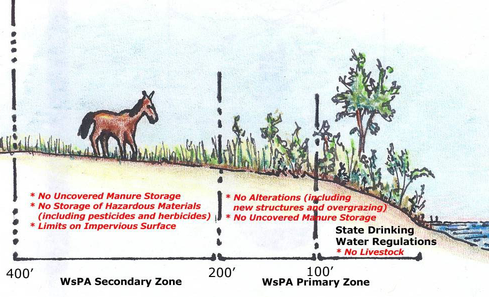
The Watershed Protection Act allows pasturing of animals in the Secondary Protection Zones. Some of the limits to working in the Secondary Protection Zone include: the total area of impervious surface, the outdoor storage of chemicals, and alterations to Bordering Vegetated Wetlands.
Outdoor uncovered storage of manure is not allowed by the WsPA in either the Primary or Secondary Protection Zone.
WsPA Exemptions for Horse Owners
There are two exemptions to the Watershed Protection Act that a horse owner may possibly qualify to utilize.
- 313 CMR 11.05(2) allows for the “reconstruction, extension or structural change” to any structure lawfully in existence as of July 1, 1992. If an owner can demonstrate that a structure, such as a barn or paddock, existed as of July 1, 1992, then work can be done on it, as long as the construction “does not cause a substantial change and degrade the quality of the water in the Watershed.”
- 313 CMR 11.05(7) provides an Agricultural Use exemption. The WsPA utilizes the definition of “Agricultural Use” found in the Wetlands Protection Act (310 CMR 10.04). In order to obtain this exemption the land owner must provide proof that horses are actively being bred and raised for commercial purposes.
Please contact the appropriate DCR field office, as identified below, if you have questions concerning the WsPA, exemptions, or variances.
Other Laws that Affect Horses
Another section of the DCR Watershed Management regulations, 313 CMR 11.09, does not allow anyone, in general, to degrade the quality of water in the Watershed System. 313 CMR 11.09(1)(b)2 states that, “no person shall construct, establish or maintain any agricultural facility or place where animal manure may be deposited or accumulated without adequate provision to prevent any manure or other Pollutant from flowing or being washed into the Waters of the Watershed System.”
There are other state and local laws not administered by DCR that affect horse owners:
- State drinking water regulations, 310 CMR 22.20B(4), require that “No stabling, hitching, standing, feeding or grazing of livestock or other domestic animals shall be located, constructed, or maintained within 100 feet of the bank of a surface water source or tributary thereto.”
- The Wetlands Protection Act, 310 CMR 10.00, does not allow the alteration of bordering vegetated wetlands.
- There may also be local zoning and board of health regulations that could affect the location and management of horses.
Property owners should contact their local Building Inspector, Conservation Commission, and Board of Health to identify all pertinent local regulations for a particular community.
Lake Front Property and the Watershed Protection Act
Brochures and Other Guidance
Contact Information
Quabbin Reservoir and Ware River Watershed Communities
DCR Division of Water Supply Protection
Quabbin/Ware Region
485 Ware Rd.
Belchertown, MA 01007
(413) 213-7935
allan.rantala@mass.gov
Wachusett Reservoir Watershed Communities
DCR Division of Water Supply Protection
Wachusett/Sudbury Region
180 Beaman St.
West Boylston, MA 01583
(857) 303-5427
Bernadette.DeBlander2@mass.gov
| Last updated: | May 15, 2025 |
|---|