Location listing filters
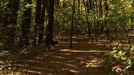
Map for F. Gilbert Hills State Forest
Note for screen reader users, we suggest skip the following interactive map and go to the location listing for a better user experience.
Currently, the map is not accessible yet for a comprehensive experience.
skip to the location listing
Location Listing
Showing 1 - 2 of 2 results for Other locations related to F. Gilbert Hills State Forest
-

Franklin State Forest
80 Forge Hill Rd, Franklin, MA 02038 DirectionsCovering over 843 acres, Franklin State Forest is a minimally developed piece of land. The forest offers miles of weaving trails and fire roads. Trails are open for hiking, mountain biking, and cross-country skiing. Additionally there is a designated loop for off-roading. Access to the Southern New England Trunkline Trail is available through the forest.Phone(508) 543-9084 -
Wrentham State Forest
690 Taunton St, Wrentham, MA 02093 DirectionsCovering over 1,000 acres, Wrentham State Forest is a minimally developed area. The gravel parking area on Taunton Street leads to miles of weaving trails and dirt roads. Trails are open for hiking, mountain biking, and cross-country skiing. Additionally there is a designated loop trail for off-roading. Motorized use at this forest is restricted to Motorcycles only. The park also offers access to the Warner Trail, a 30-mile hiking trail that travels through Norfolk County down to Rhode Island.Phone(508) 543-9084