Location listing filters
Map for Ware River Watershed
Note for screen reader users, we suggest skip the following interactive map and go to the location listing for a better user experience.
Currently, the map is not accessible yet for a comprehensive experience.
skip to the location listing
Location Listing
Showing 1 - 3 of 3 results for Other locations related to Ware River Watershed
-
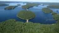
Quabbin Reservoir
100 Winsor Dam Rd., Belchertown , MA 01007 DirectionsQuabbin Reservoir is one of the largest unfiltered water supplies in the United States. Along with the Wachusett Reservoir and Ware River, it is the source of high quality water for the Massachusetts Water Resources Authority water supply system. The 412 billion gallon reservoir covers 39 square miles with 181 miles of shoreline. Recreational activities are regulated and limited to protect 2.7 million people’s drinking water.Phone(413) 323-7221-
General restrictions allow visitors through designated gates and areas one hour before sunrise and one hour after sunset. However, this does not apply to vehicle access.
-
-
Rutland State Park
49 Whitehall Road, Rutland, MA 01543 DirectionsHike the trails across 300-acre Rutland State Park. You can also visit Whitehall Pond to swim, boat, or picnic near the beach.Phone(508) 886-6333-
Sunrise to sunset
-
-
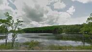
Wachusett Reservoir
180 Beaman St., West Boylston, MA 01583 DirectionsWachusett Reservoir, along with the Quabbin Reservoir and Ware River, are the unfiltered source of high quality water for the Massachusetts Water Resources Authority water supply system. The 65 billion gallon reservoir covers 6.5 square miles with 37 miles of shoreline. Recreational activities are regulated and limited to protect 2.7 million people’s drinking water.Phone(508) 792-7806-
One hour before sunrise to one hour after sunset.
-