
- Department of Conservation & Recreation
Media Contact
Peter Jasinski, DCR Press Secretary
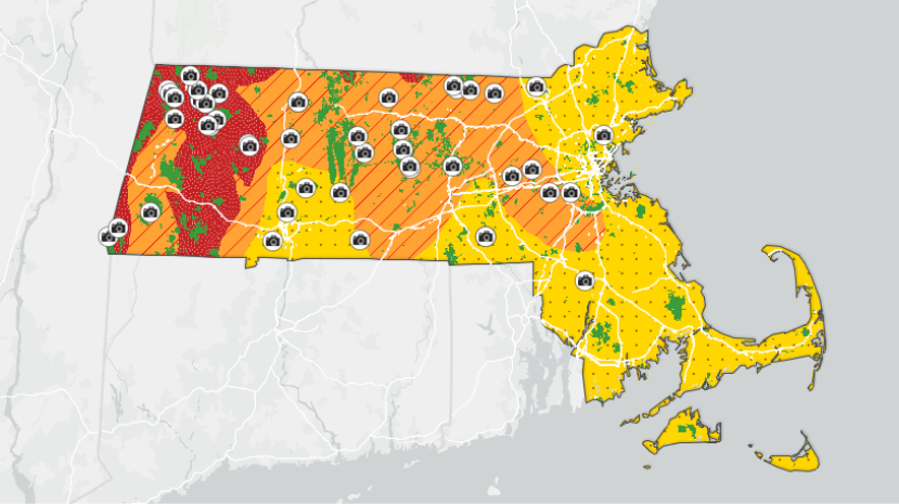
BOSTON — Continuing its efforts to ensure Massachusetts residents and visitors get the most out of fall in New England, the Department of Conservation and Recreation (DCR) today announced the return of its Interactive Fall Foliage Map, which has been updated for the 2026 season. The map depicts foliage conditions across the state, showing where leaves have begun to change, as well as how far they are in the process.
“Fall is one of the best times to get out and enjoy Massachusetts, and our state parks are some of the most beautiful places to see the season change,” said Governor Maura Healey. “This interactive map makes it easier for residents and visitors to find peak foliage, explore different parts of the state and experience everything our parks and communities have to offer.”
“From the Berkshires to the North Shore, fall brings people together to enjoy the outdoors and discover communities across Massachusetts,” said Lieutenant Governor Kim Driscoll. “The Fall Foliage Map is a great tool to help families and visitors plan a trip, explore our state parks and make the most of the season.”
“We take fall very seriously in Massachusetts, and we want everyone to be able to enjoy the best New England has to offer,” said DCR Commissioner Nicole LaChapelle “DCR properties are home to beautiful forests that come to life with the colors of fall. Each year, our Foliage Map helps guide thousands of people to where the leaves are most colorful so that they can experience all the magic of the fall season.”
DCR’s Interactive Fall Foliage Map enables users to prepare for leaf peeping by searching based on geography and calendar dates. The map can also search for foliage activity at specific DCR properties so that visitors can plan their trip around when colors will be most vibrant. The map also features photos taken by DCR staff, allowing visitors to see current conditions before setting out to a park.
Through a combined analysis of forestry records from past falls and data on current weather patterns, DCR is able to map where and when leaves are most likely to start changing colors. Foliage activity is expected to peak in mid-October this year. As with previous years, Western Massachusetts is expected to reach peak colors before the rest of the state.
The Interactive Fall Foliage Map is easily accessible on both desktop and mobile devices and can be found online at DCR’s Fall Foliage webpage. Agency social media channels will also share foliage content throughout the season.
DCR’s Fall Foliage webpage also highlights recommended ideal foliage viewing spots in the state park system, along with hiking trails, picnic areas, and scenic overlooks at the locations.
###