Water Supply System Construction, 1895-1926
This treasure trove of 8,800 photographs documents the construction and early operation of the water supply distribution system throughout metropolitan Boston at the start of the 20th Century. The collection covers the:
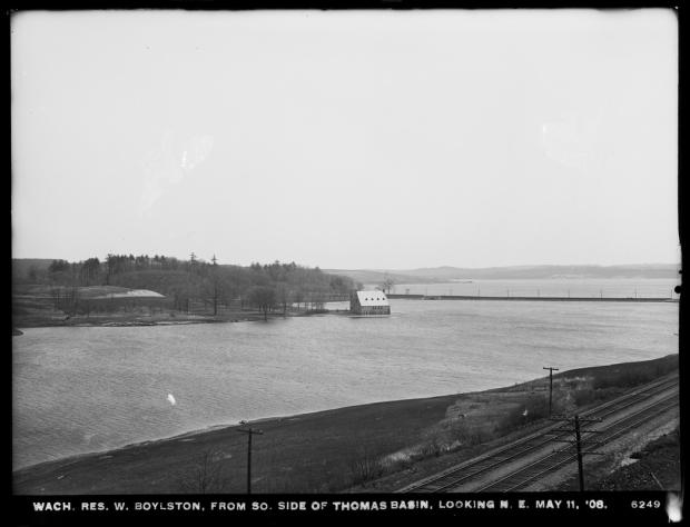
- Wachusett Reservoir
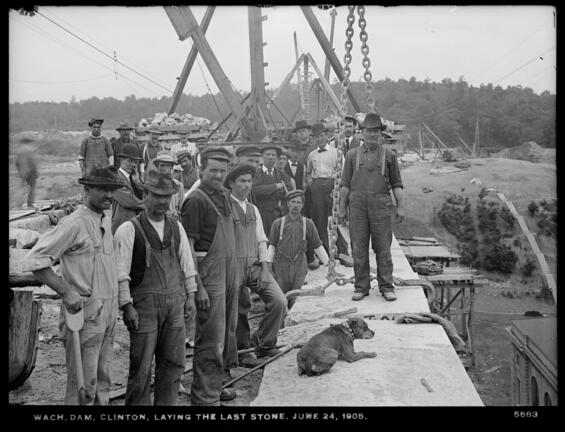
- Wachusett Dam
- Wachusett Aqueduct
- Sudbury Reservoir
- Sudbury Dam
- Weston Aqueduct
- Weston Reservoir
- Associated pipe lines, pumping stations, reservoirs, and standpipes.
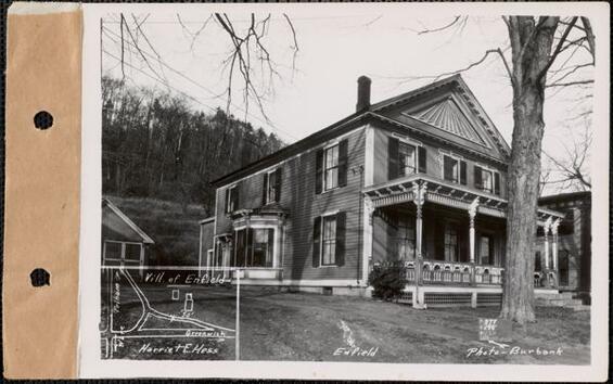
The images include homes, businesses, mills, town buildings, schools, churches, cemeteries, and railroad stations. About 50 different cities and towns, as well as several Boston neighborhood districts, can be seen in this collection. These pictures, mostly derived from 7,839 glass plate negatives, represent the Boston area’s drinking water system prior to the 1926-1940 expansion that culminated in the construction of the Quabbin Reservoir.
Click here for the Metropolitan Water Works Photograph Collection.
Once you are on the MWW Photo Collection page, there are a various ways to search the files:
- Browse by topic or by place (city/town) from the right
- Search by a word, or phrase. Be creative! Many more words are searchable than in browse by topic (note: land owner name most likely spelled with a 's, so if no result is found, try variations of the 's)
- After results appear, you can sort by date; and, if needed, change number of images per page
- Clicking on a single result, the top portion of the page will be the image and bottom portion the catalog record of the image. Click on the image, and a scale-able image appears.
Water System Plans
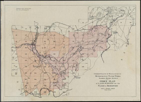
Associated with the MWW Photo Collection is a set of 72 Wachusett Reservoir land survey blueprints. These blueprints were annotated by the MWW engineers with the photo number of 1,432 real estate images. There are links on the survey page and the photo collection page to connect to each other. You can find the place of a picture from the photo collection on the survey, or vice versa:
- Search by MWW image number. That number can be found in the catalog record obtained by the instructions above. Look for either the accession number or identifier. The image number is the digits that follows "EN4.05/2630X" in the accession field; it is the same number, without the leading zeros and without the leading MWW, in the identifier field.
- Click on the image result, and in the catalog record below, verify that the image number is located on that blueprint sheet (image numbers are listed in the notes field).
- Click the blueprint image to enlarge. Scroll around to locate the image number, which are annotated in red ink.
Utilize two separate windows – one for the blueprints and the other for the photos – to compare the image to its location on the map!
Quabbin Cemetery Photographs
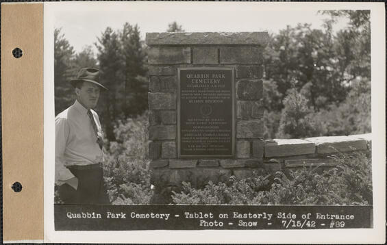
As part of the construction of the Quabbin Reservoir, Dam and Aqueduct, a new cemetery was required to replace those that would be flooded as part of Boston's drinking water supply. The new 30-acre Quabbin Park Cemetery was built in Ware, MA, and officially opened on August 25, 1932. The Cemetery is managed by the Department of Conservation and Recreation, Division of Water Supply Protection, Office of Watershed Management, Quabbin Region.
This collection consists of 2,083 photographic prints (5 x 7 inches) and 26 engineering plans of the former cemeteries and the current Quabbin Park cemetery.
Click here for Quabbin Cemetery Historic Photograph Collection
Additional Resources
Real Estate in the Swift River Valley and General Engineering of Quabbin Reservoir
This photograph collection consists of more than 2,900 prints that document each structure that was part of the real estate purchases and removal processes made to create the Quabbin Reservoir. Photographs were also taken of preliminary engineering work, nursery and tree planting work, gypsy moth defoliation, the 1936 floods, milestone events with officials, as well as landscape views of the Swift River valley.
Ware River Watershed, 1928-1948
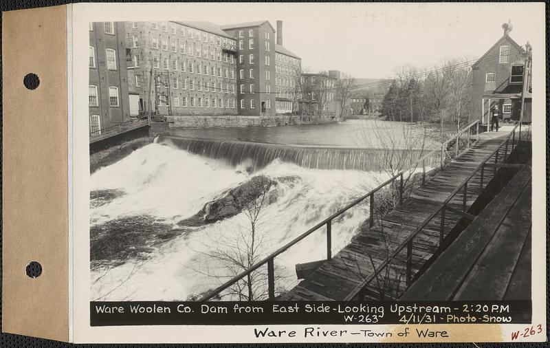
A vital component of the Quabbin Reservoir project was the "sanitary protection," for water supply purposes, of the Ware River Watershed, specifically the upper watershed, from the village of Coldbrook, Barre, and above, as floodwaters from the upper watershed are diverted through the Quabbin Aqueduct (at the Ware River Intake and Diversion Works), westward, into the Quabbin Reservoir. The upper Ware Water Watershed consists of 96.8 square miles, and contains nearly all of the town of Hubbardston, the greater part of Rutland, parts of Barre, Phillipston and Templeton, and lesser parts of Oakham, Princeton and Westminster. The real estate was purchased in these towns for sanitary protection.
Engineering photographers were employed to document the buildings and structures of about 21 manufacturing factories, along with damage incurred from record setting floods in 1936 and 1938 floods. Flood damage in the town of Ware, along the Ware River, is also documented from the devastating September 1938 flood and hurricane.
This collection consists of 1,923 photographic prints (5”x7”), and 64 original negatives (5”x7”) for photo prints that do not survive.
Quabbin Construction Contracts 1928-1947
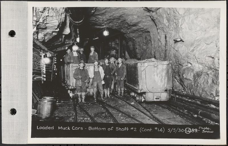
This photograph collection consists of more than 3,750 (to date) prints between 1928 and 1947 that document construction contracts for the Quabbin Reservoir and related structures. The structures constructed through these contracts included the 24.6 mile-long Quabbin Aqueduct tunnel and related shafts and shaft buildings, the main Quabbin Reservoir dam (the 2,640 feet long Winsor Dam) and dike (Greenough Dike), the Quabbin Reservoir baffle dams, various intake and outlet buildings, 36 miles of highway and roadway construction (in addition to access roads), reservoir clearing, construction of the Quabbin Administration Building Complex, Quabbin Observation Tower, the Quabbin Park Cemetery Building, a work boat (designed by a MIT naval architect), the Rutland-Holden sewer infrastructure (for Ware River Watershed), amongst other lesser contracts.
In addition, following an extensive engineering study in 1936-1937, authorization was granted in 1938 to construct additional structures to improve the distribution and water quality of metropolitan Boston’s water supply system (St 1938, c 501). Spanning about 12 construction contracts these structures included the Pressure Aqueduct (the 18 mile-long Hultman Aqueduct), Norumbega Reservoir at the terminus of that aqueduct, and the enlargement of the Fells Reservoir within the Middlesex Fells Reservation, a state park north of Boston. The construction of these structures was completed in 1940, with the new aqueduct opening on October 23, 1940.
All of these subjects are photographically documented in this specific photograph collection. The work of cataloging and digitizing these photographs remains in progress and not all construction contracts and the structures documented are available at this time, spanning those for the Quabbin Dam, Quabbin Dike, and for the Hultman Aqueduct.
History of the Metropolitan Water Works Photograph Collection
You can go to the DCR Archives web page for more information about the entire agency’s documented history.