Waquoit Bay ACEC Designation Document
Approximate acreage: 2,575 acres
Watershed/subwatershed: Cape Cod/Waquoit Bay
Municipalities (% of ACEC): Falmouth (48%) and Mashpee (52%)
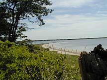
The Waquoit Bay ACEC was nominated by the Conservation Commissions, Boards of Selectmen, and Waterways Committees in the Towns of Mashpee and Falmouth and was designated as an ACEC in 1979 because of the area’s extraordinary natural resources. The ACEC boundary generally follows the 100-year floodplain elevation on the landward side of the bay and mean low water on the seaward side and includes the Waquoit Bay National Estuarine Research Reserve (WBNERR). The entire Bay is designated by the state as an Ocean Sanctuary while much of the surrounding upland is also part of the Mashpee National Wildlife Refuge. Important habitats within the boundary include estuarine waters, freshwater wetlands and ponds, shrub and wooded swamps, streams, salt marsh, tidal flats, coastal dunes, and beaches. These areas provide flood control, storm damage prevention, improved water quality, wildlife habitat, and recreation opportunities to surrounding communities.
What coastal resources are included (partially or entirely) in the ACEC?
- Harbors, Sounds, Bays: Waquoit Bay (Falmouth, Mashpee)
- Rivers: Childs River, Quashnet River (Falmouth)
- Lakes, Ponds: Bog, Bourne, Caleb, and Hamblin Ponds (Falmouth); Flat, Hamblin, Jehu, Jim, Little Flat, Sage Lot, and Witch Ponds (Mashpee)
- Brooks, Creeks: Red Brook (Mashpee)
- Great Ponds (ponds > 10 acres): Jim Pond (Mashpee)
Outstanding Resource Waters (ORWs): Waquoit Bay and Hamblin Pond (Falmouth, Mashpee); Childs River, Quashnet River, Bog, Bourne, and Caleb Ponds (Falmouth); Flat, Hamblin, Jehu, Jim, Sage Lot, and Witch Ponds, Red Brook (Mashpee). (ORWs are waters, such as public water supplies and vernal pools that are protected by the most stringent standards because they constitute an outstanding resource as determined by their socio-economic, recreational, ecological, and/or aesthetic values).
Barrier Beaches included in ACEC (Massachusetts Barrier Beach Inventory, CZM, 1982): in Falmouth - on Washburn Island: beach to west of bay inlet (Fm-1), beach to east of Eel Pond Inlet (Fm-11), areas fronting marshes on east side of island (Fm-7,8,9), beach on west side of island opposite Bayview Drive (Fm-10); within Waquoit Bay: mouth of Quashnet River (Fm-3,4), area fronting Caleb Pond (Fm-5), fronting pond south of Waquoit cemetery (Fm-6), fronting Hamblin Pond (Fm-2); in Mashpee: South Cape Beach/Dead Neck (Ms-5), beach east of inlet and fronting Flat Pond and Sage Lot Pond (Ms-9)
Maps
Maps are intended to be used with the written boundary description contained in the ACEC designation document. The mapped boundary is not to be used by itself for definitive ACEC boundary delineation or regulatory interpretation. For review of site-specific projects in or bordering the ACEC, determinations must be made in the field by a certified professional in consultation with the appropriate Conservation Commission(s) and ACEC Program Staff.