
Project Details
Project Title
Shawsheen River Nature-Based Flood Resilience
Municipality
Andover
MVP Region
Northeast
Award Year
FY2023
Grant Award
$271,705
Project Length
One year
Project Website
Community Overview
- Community size and location: The Town of Andover has a population of approximately 36,500 people and is located in Essex County, approximately 20 miles northwest of Boston.
- Environmental Justice and climate vulnerable communities: While Andover is one of Massachusetts’ wealthier communities,17.45% of Andover households (over 2,100 households in total) have incomes below $50,000. Andover also contains a large mapped environmental justice (EJ) community north of I-495. This EJ community has a median household income of $176,645 (well above the state median of $85,843) but is mapped as having a 48.3% minority population, with 20.9% of households with language isolation. Portions of this EJ community also overlap with the FEMA floodplains for the Merrimack River and Fish Brook. The EPA’s EJScreen tool identifies additional areas in Andover as meeting demographic indicators of EJ communities. The neighborhood South of I-495 in Shawsheen Heights near the Shawsheen River is mapped as having 13% of its population under the age of 5, putting it at the 93rd percentile nationally for this vulnerable population. The EJScreen tool also indicates that the flood prone area along the Shawsheen River south of the Stevens Street bridge is mapped as having 29% of its population over the age of 64 (88th percentile); a similarly mapped area occurs just west of North Main Street along the Shawsheen (over 25% of residents over the age of 64; 82nd percentile). One additional area in the same vicinity (along High Street) is mapped as 8% linguistically isolated (82nd percentile). There are three high-density, low-income housing communities along the Shawsheen River at an elevated risk from flooding: Andover Commons (50% of units are reserved for residents with incomes less than 50% of AMI), Marland Place (senior housing), and Frye Circle (a 96-unit Andover Housing Authority property that houses elderly and disabled residents). Marland Place, in particular, is recognized and categorized as having an extreme flood risk by the First Street Foundation’s Flood Factor Tool. Furthermore, ResilientMass indicates that the neighboring downstream City of Lawrence is mapped entirely as EJ communities based on the percentage of minorities, with many areas also mapped for English language isolation and/or income. The median household income for one mapped EJ community in the downtown Lawrence area is $18,882, with a 98.5% minority population, and 50.8% of households with language isolation.
- Unique traits: Andover is an inland Town with significant waterbodies including the Shawsheen River, Fosters Pond, Pomps Pond, Haggetts Pond, and the Merrimack River forming the Northern border. Architecture found in Andover reflects the Town’s historic past as a mill town, established in part with water power from the Shawsheen River. The region’s first powder mill was established in Andover in 1775, and shortly after followed paper manufacturing and several textile mills. Andover is also known for being the home of Phillips Academy, one of the nation’s oldest incorporated secondary schools.
Project Description and Goals
- Location: The project was located along the Shawsheen River in Andover, extending into the neighboring City of Lawrence downstream.
- Climate impact: The Town’s MVP planning process in 2019 identified flooding as a particular hazard of concern following serious flooding events in May 2006 and March 2010. These major flooding events were triggered by heavy rainfall and caused many roads to close, schools to cancel classes, and residents to evacuate their homes. Climate projections analyzed during the prior year’s project indicated total annual precipitation is expected to increase by 2.34 inches from 2020 to 2049 over historical averages from 1971-2000, while the annual days with precipitation greater than 2 inches are expected to increase by 23%.
- Goals and tasks: This phase of the MVP project focused on quantifying the flood mitigation benefits gained from future flood storage and/or restoration projects on high priority parcels of land along the Shawsheen River. Specifically, hydrologic and hydraulic (H&H) modeling was carried out to evaluate the existing and projected future flooding conditions. The project also included a multiday visioning workshop and design charrette held with community members to co-create nature-based conceptual restoration and flood storage projects along the Shawsheen River in the Town of Andover.
- Meeting MVP goals:
- Used a science-based approach to incorporate nature-based solutions to address future climate-exacerbated flooding in the following ways:
- Quantifying current and future flooding impacts by developing a HEC-RAS model of the Shawsheen River that updates prior models with future climate projections;
- Developing novel nature-based project concepts for three high-impact sites along the Shawsheen River (Lower Shawsheen Soccer Field, Stevens Street Parcel, and the Sacred Heart Reservation) and quantifying the flood mitigation impacts of the planned nature-based solutions.
- Improved equitable outcomes for and fostering strong partnerships with EJ and other climate vulnerable populations: This was accomplished by replicating the desktop site screen tool developed in the last phase of the Andover project and extending the work to identify flood mitigation project sites in the neighboring City of Lawrence, and by discussing the modeling work with residents of the Washington Park Condos who have suffered repeated flood loss events.
- Provided regional benefits:
- Enabled Abbott Lawrence High School students to take a class trip to the Ecology School in Saco, Maine to gain additional insights on how critical watersheds and river systems are to the health and safety of communities and protecting wildlife habitats;
- Established new connections to the Groundwork Lawrence and Essex County Greenbelt Association organizations through the planning and implementation of a multi-community public hiking and environmental educational event at the Den Rock Park reservation in Lawrence and Andover. Presenters and partners included the City of Lawrence residents, Lawrence Conservation Commission, Ground Work Lawrence, Andover Conservation Commission, Essex Greenbelt, the Merrimack River Watershed Council, the New England Flying Squirrel Network and the Andover High School Environmental Club.
- Meaningful community engagement: Although four major successful outreach events were executed throughout the project this year (Resilience Workshop in April; Den Rock Hike and Public Walk-shop in May, and a virtual Community Design Debut in June) the project was not as successful as we would have liked in terms of recruiting a community liaison to further engage the City of Lawrence. The planned hiring of a bilingual student from the Greater Lawrence Technical School required undergoing a formal hiring process through the Town of Andover. This required the creation of a position description by Human Resources, for which there was no prior Andover Town Meeting approval to support. Other attempts to identify an alternate community liaison outside of school setting were not successful.
- Used a science-based approach to incorporate nature-based solutions to address future climate-exacerbated flooding in the following ways:
Results and Deliverables
The FY23 MVP project continues the progress made in identifying impactful parcels in the prior phase of the project and asks about the flood mitigation impact of deploying nature-based solutions on these parcels. To do so, a hydrologic and hydraulic (H&H) model was developed for the Shawsheen River to assess river flows within current climatic conditions as well as project conditions anticipated in 2030 and 2070, with the latter years incorporating more frequent and intense storm impacts brought on by climate change. The model was also calibrated using the USGS Balmoral Station stream gauge data that describe actual historic conditions from 2010 to the present.
Three Andover land parcels abutting the Shawsheen River were chosen for further characterization: 56 York Street Parking Lot, Lower Shawsheen Field, and the Stevens Street parcels (listed from the northernmost to southernmost parcels). These parcels ranked among the most promising sites identified, representing not only larger open areas with more room to store floodwaters but also proximity to populations vulnerable to flooding. Two of these parcels - York Street and Stevens Street - are privately held, and the Lower Shawsheen Field is owned by the Town of Andover. The Stevens Street parcels not only have additional benefits in terms of ecological restoration but also are highly coveted by the Andover Open Space Task Force, which sees the parcels as a great opportunity to link adjoining protected lands. The York Street parcel is already marked as a flood-prone area but could be restored to reduce impervious pavement and flood storage. Last but not least, the Lower Shawsheen Field, - currently serving as a soccer field and track - would be ideal for river flow diversion and storage during intense storms, which may help to alleviate flooding on nearby residential properties.
Once these three top sites were identified, Fuss & O’Neill hosted a public “walk-shop” on May 22nd, 2023, to gather community input that ultimately was incorporated into the final design and H&H modeling work. Each of these parcels was assessed separately.
Of these parcels, the Stevens Street conceptual design was the most impactful. The new design involves raising the current Stevens Street Bridge by 3 feet and raising the road by 1 foot, in addition to incorporating nature-based solutions for river restoration and improving public access. The larger bridge opening allows the crossing to be sized for a 100-year storm in 2070 and reduced the 100-year flood depth by 1 foot between Stevens Street and Essex Street. The work would also involve adding stone cross vanes to support habitat creation and aeration of the river’s 4 flows. Other amenities might include a river and wildlife viewing deck, a trail loop, and an access road with parking. The estimated cost of the Stevens Street concept is $8 million, with the bridge elevation increase being the costliest component at $2.5 million.
A key question we sought to answer is whether the removal of the Ballardvale Dam, the sole obstacle to migrating aquatic wildlife that remains in the 25-miles long Shawsheen River, would impact future riverine flooding conditions. Disappointingly, we learned from the model that while removing the dam can lead to a difference in water depths at the dam’s location, water levels 50 feet downstream of the dam and 2 miles upstream of the dam will remain within one inch of the initial conditions.
A key aspect of the work involved the addition of Gonzaga University professor, Dr. Sue Niezgoda and her four engineering students, who collaborated with the Fuss & O’Neill technical team to extend the desktop screening process developed earlier with the prior project to the City of Lawrence 5 parcels. The Gonzaga team’s work required generating 15 maps within ArcGIS Pro and focused on parcels located within 100 meters of the 500-year FEMA floodplain. The mapping work took into account social and community assets (EJ priority areas and open space/recreational areas), as well as environment and ecology factors (landscape diversity, local connectivity, ecological integrity, etc). The Lawrence areas where multiple desktop site screenings converge would yield high priority parcels to ground-truth in the future. The students also used H&H modeling to determine the projected peak flows at the Shawsheen and Merrimack River confluence and were able to determine that 2070 conditions would increase peak flows from 3000 to nearly 5000 cfs, introducing new areas of at-risk properties in the future.
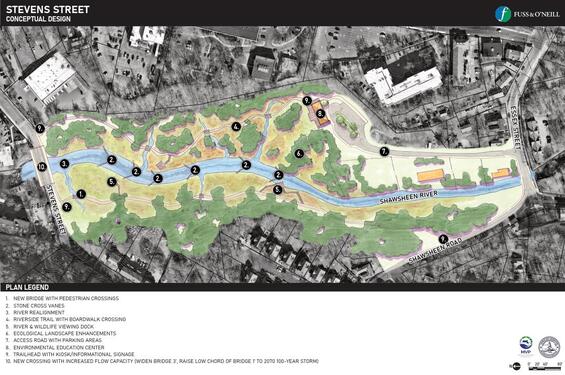
Stevens Street conceptual design.
Lessons Learned
There were two major lessons learned during this project:
- Flood mitigation work in Andover is likely to consist of multiple nature-based solution implementations, as well as substantial gray infrastructure updates. The three sites examined during this project offered 1 foot or less of flood depth reduction by 2070, leaving many properties exposed to multiple flood losses. Removal of Ballardvale Dam also does not greatly alleviate downstream flood-prone properties, although its removal would lower the risk of additional harm associated with dam failure during storms. The modeling work shows that many Andover properties that are in the current 100-year flood plain will likely be in the future 10-year flood plain; de-risking flood impacts will require either substantial property elevations or in some cases, managed retreat.
- Second, community liaison work in the City of Lawrence to raise awareness about Andover projects that impact the Lawrence community can best be done by a permanent staff of an established grassroots organization with experience working in local neighborhoods, as well as ideally established relationships with City of Lawrence officials. The concept of enlisting the assistance of a bilingual student at the Greater Lawrence Technical School to serve that role, born of our earlier successes in working with high school students, was ultimately unworkable due to administrative challenges.
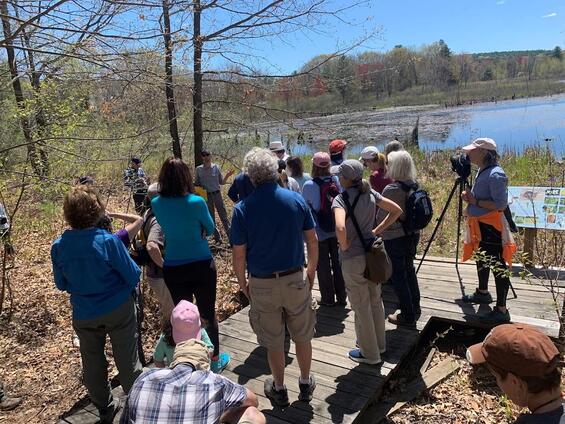
Andover Conservation Agent Explains Wetland Features in Den Rock Park Hike in Lawrence in May, 2023.
Partners and Other Support
- Town Departments:
- Grant Management
- Engineering Division
- Conservation Division
- GIS Division
- Fuss & O’Neill
- Groundwork Lawrence
- Essex County Greenbelt Association
- Merrimack River Watershed Council