Project Details
Project Title
Baptist Corner Road Stream Crossing Ecological Improvements
Municipality
Town of Ashfield
MVP Region
Berkshires & Hilltowns
Award Year
FY2022
Grant Award
$548,600
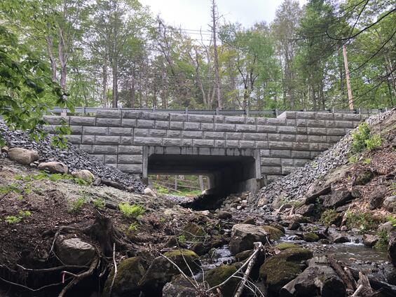
The finished Baptist Road Culvert in Ashfield, MA - looking upstream.
Community Overview
Ashfield is located in northwestern Massachusetts approximately 31 miles east of Pittsfield. It has an approximate population of 1,700 residents. While there are no Environmental Justice (EJ) communities in Ashfield, the rural nature impacts some of the Town’s infrastructure, public safety, and emergency service access, in the face of flooding from increased storm intensity precipitation and frequency. Replacing undersized crossings with adequately sized structures adds to the overall climate resiliency of the community and increases safety by eliminating potential dead-end situations caused by culvert and road washouts.
Ashfield was first settled in 1743 and was officially incorporated in 1765. The Town occupies roughly 40 square miles of land. It is comprised of mostly rural developed land and mountainous/wooded terrain. Ashfield lies in the eastern foothills of The Berkshires, with several high hills, including Ridge Hill, in the northern portion of town. The town is fed by several rivers and brooks, including the South River, the "western" Swift River (the "eastern" river flows out of the Quabbin Reservoir in central Massachusetts) and several prominent brooks, most of which feed into either the Deerfield River or the Connecticut River. Near the center of town, Ashfield Lake feeds into the South River, and is a recreational site. In the southwest portion of town, a small portion of the Poland Brook Wildlife Management Area crosses into town, as does a portion of the Daughters of the American Revolution State Forest. Ashfield is the birthplace of prominent director Cecil B. DeMille (whose parents were vacationing in the town at the time).
Project Description and Goals
The project is located along Baptist Corner Road over an unnamed tributary to Bear River within Ashfield, MA. The project addresses climate change related increased precipitation amount and frequency (flooding) since the newly installed culvert increased in span and rise when compared to existing conditions and flood resilience was increased. The new culvert is capable of handling a 100-year storm event without flooding the roadway.
The project goals and tasks for this project were to:
- Implement a climate resilient road crossing, increasing community flood resilience and increasing aquatic organism and wildlife passage;
- Improving equitable outcomes for and fostering strong partnerships with EJ and other Climate Vulnerable Populations: flood resilience for the population relying on Baptist Corner Road for commuter and emergency access was vastly increased;
- Providing regional benefits: Baptist Corner Road is a major connector between Ashfield and Buckland/Conway;
- Implementing the public involvement and community engagement plan: the Baptist Corner Road site is a Massachusetts Department of Fish and Game Division of Ecological Restoration (DER) Regional Training Site which is used as a case study for neighboring Highway and Public Works Departments of the benefits of implementing a crossing meeting the Massachusetts Stream Crossing Standards.
The project met these goals by:
- Increasing sustainability and climate change resilience in the form of increasing the flood event capacity;
- Creating streambanks within the structure and widening the structure to better support hydraulics and both aquatic / terrestrial wildlife movement;
- Improving public safety.
Results and Deliverables
The newly constructed culvert increased from a deteriorated 5-foot diameter corrugated metal pipe to a 19-foot span by 4-foot rise precast concrete box culvert. Hydraulic capacity of the culvert increased from handling a 25-year storm to a 100-year storm. Banks and natural streambed material were installed within the new culvert. Enhanced wildlife access to over 260 acres of habitat and ¼ mile of mountain stream was added by eliminating the undersized, perched crossing.
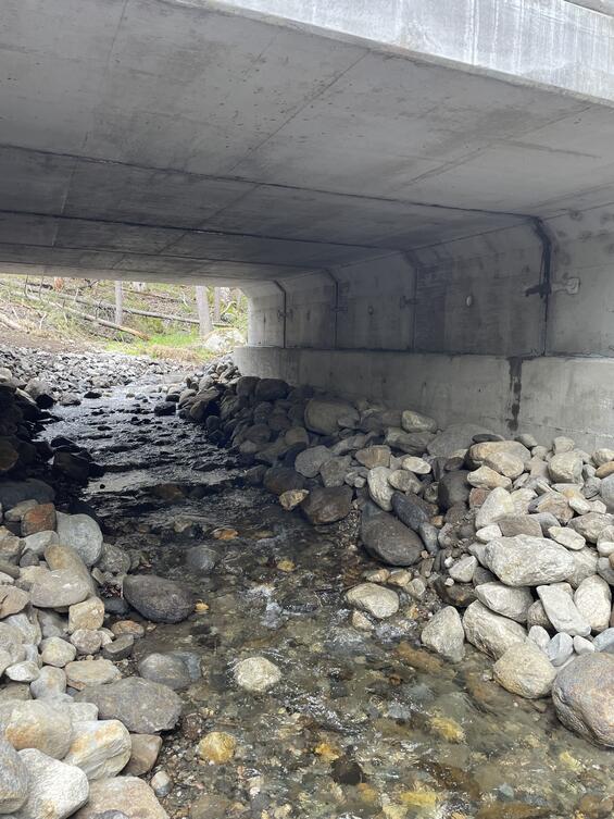
The upgraded culvert has internal natural stream substrate and banks, allowing for more water and wildlife passage.
Lessons Learned
- Make sure regular communication with all stakeholders takes place (such as regular progress meeting with all parties involved with the project (municipality, funding agency, lead design engineer, selected contractor, etc.);
- Allow adequate schedule and financial resources for the new MassDOT Chapter 85 two-part approval process;
- Contractor changes to design which require MassDOT approval should be avoided to the maximum extent practicable.
Partners and Other Support
- Town of Ashfield – Highway Department (Client)
- Municipal Vulnerability Preparedness Program (Funding Agency)
- Comprehensive Environmental Inc. (Lead Design Engineer)
- Kenefick Corp. (Lead Contractor)
- Massachusetts Department of Transportation (Technical Reviewing Agency)
- AI Engineers (Peer Review Structural Engineer)
- Concrete Systems Inc. (sub-contractor / precast manufacturer)
- Pretek Group (sub-contractor)
- Arrow Concrete Products (sub-contractor)
- SFC Engineering Partnership, Inc. (sub-contractor)