
Project Details
Project Title
NO-HEAT: Neutralizing Onerous Heat Effects on Active Transportation
Municipality or Organization
Boston Region MPO & MAPC (& Chelsea, Everett, Framingham, Revere)
MVP Region
Greater Boston
Award Year
FY2025
Grant Award
$1,001,100
Project Website
Project Overview
This project aimed at improving heat resilience capacity and enhancing climate justice in the 97 communities comprising the Boston metropolitan region by creating unique high-resolution regional heat risk and mobility datasets that can aid in targeted mitigation interventions. It demonstrated their use, in conjunction with outreach and community engagement, in informing resilient planning efforts through heat relief pilots and wayfinding recommendations that are aimed at enhancing the safety and comfort of people walking and biking.
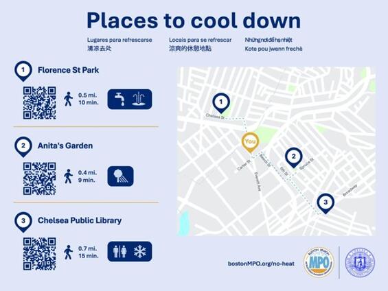
Digital copy of multilingual signage in Chelsea
Community Overview
The Boston Region MPO represents 97 cities and towns, with a combined population of 3.4 million residents. The NO-HEAT project developed heat-risk data for the entire region. We partnered with the cities of Chelsea (population 39,908), Everett (50,045), Revere (population 60,012), and Framingham (population 73,356).
Both the Boston region broadly and the four communities we worked with specifically have significant Environmental Justice and other Climate Vulnerable communities. In addition, Chelsea, Everett, and Revere have a high share of residents who commute to work using transit, walking, or biking, and a high share of households without access to a private vehicle (or zero-vehicle households) relative to the rest of the Commonwealth. A reliance on active transportation leaves these communities more exposed to extreme heat.
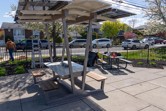
Shade intervention installed in Revere, MA
MVP Core Principles Exemplified
The MVP Core Principles that this project exemplifies includes:
1. Pursuing innovative, transferable approaches
2. Achieving broad and multiple community benefits
3. Building community capacity for climate resilience
Project Goals
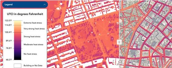
The NO-HEAT project produced regional datasets that estimate heat exposure for people walking, biking, and taking public transit throughout the Boston region. In partnership with the Georgia Institute of Technology, the MPO developed high-resolution microclimate data that measures the Universal Thermal Climate Index (UTCI) for every street in the region. UTCI considers factors including sun angle, shadows from buildings and trees, land cover, wind speed, air temperature, and humidity. Unlike more commonly used heat measures, such as land surface temperature or air temperature, UTCI is a human-centric measure that captures how the human body experiences heat.
The MPO combined UTCI data with active transportation mobility data to identify where people moving through the region are most exposed to extreme heat. With these datasets, we can see differences in a person’s heat exposure when traveling along a tree-lined sidewalk compared with the bare pavement across the street. The data are publicly available, along with webinars explaining how to use and recreate the datasets. To ground-truth the data, we conducted walk and bike audits with our community-based partners (WalkMassachusetts, MassBike, Bike to the Sea, and the Mystic River Watershed Association) in four partner municipalities: Chelsea, Everett, Framingham, and Revere.
During these audits and other engagement events, residents shared their experiences traveling along these streets and provided input on potential heat mitigation strategies that could make it safer and more comfortable to walk, bike, roll, and take transit. Based on each community’s input, the MPO installed heat relief shade structures at three locations and conducted focus groups and workshops to evaluate the pilot structures and educate community members about extreme heat.
The MPO also installed multilingual wayfinding signs at the shade structures to direct people to nearby destinations with additional cooling amenities and partnered with Georgia Institute of Technology to develop a prototype web-based routing tool that integrates UTCI data to recommend cooler and greener routes to destinations in the four partner municipalities.
Outcomes
The NO-HEAT project produced high-resolution regional datasets that estimate where people walking, biking, and rolling are most exposed to extreme heat. They partnered with the Cities of Chelsea, Everett, Framingham, and Revere as well as advocacy organizations to conduct walk and bike audits to ground-truth the data. Based on feedback from the communities, they installed heat relief pilot interventions in three municipalities to support people walking, biking, and taking public transit.
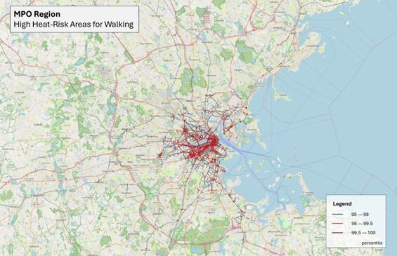
High heat-risk locations for people walking in the Boston metropolitan region.
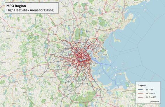
High heat-risk locations for people biking in the Boston metropolitan region.
Results and Deliverables
The NO-HEAT project produced new heat datasets, a process for prioritizing locations for heat interventions, a method to ground-truthing data with community feedback and walk-bike audits, and new heat pilot intervention in three municipalities:
- Created a microclimate dataset (UTCI) at a 1-meter resolution for the entire Boston Region, which can differentiate how hot a person would feel in a shaded section of the street compared with an area with limited share just a few steps away. The full dataset is available for download and has been accessed by municipalities, state agencies, universities, and advocacy organizations.
- Developed a UTCI data explorer that shows UTCI heat data for every street in the Boston region.
- Hosted two demonstration and training sessions for the datasets including a webinar on how to use the data to identify where it’s hot in the Boston region and a webinar on how to create this data for other regions.
- Worked with advocacy organizations to conduct six walk audits and six bike audits with community members across Chelsea, Everett, Revere, and Framingham on high heat risk corridors identified through data analysis.
- Conducted in-person engagement to capture insights from the community on their experiences about extreme heat as they walk, bike, and roll and their preferences on interventions to address heat exposure.
- Installed heat-mitigating shade structures at three high-risk locations identified through the community walk and bike audits. The first location was on the Northern Strand Trail in Everett where we installed two benches that provided shade for people walking and biking along the trail. The second location was in Chelsea at a bus top at the intersection of Carter and Everett Streets to provide shade for people using public transit. The third location was in Revere at Disalvo Park neighboring Susan B Anthony Middle School to provide shade for young people as well as people walking and biking. We also planted trees in Everett and Chelsea in coordination with DCR.
- Estimated that the combined interventions at each location could reduce UTCI by up to 6.3 degrees Fahrenheit.
- Conducted focus groups with youth in Chelsea and Revere to evaluate the heat relief pilot interventions and get their perspective on future heat relief efforts.
- Held a tabling event with interpreters, conducted surveys on the intervention to evaluate the heat relief intervention in Everett.
- Engagement event participants expressed that shaded seating was valuable for people walking, biking, and waiting for transit to be able to cool down and rest during their trips. Participants in the three municipalities gave feedback on other hot locations in their communities that they felt would benefit from shaded benches and provided input on other types of cooling interventions they would support, with tree planting, shaded benches, and water features as top preferences.
- Developed a prototype Cool Routes App, that uses the UTCI data and vegetation data to identify cooler and greener routes to reach a desired destination.
- Installed multilingual wayfinding signs at the intervention sites to direct people to nearby destinations with additional cooling amenities
Partners and Other Support
Municipalities - supported selection of audit locations, provided input on intervention locations and shade structure selection, and participated in community engagement:
- City of Chelsea
- City of Everett, City of Revere
- City of Framingham
Community-based organizations - supported qualitative data-gathering and engagement activities, including walk and bike audits, intervention tabling, and qualitative evaluation activities:
- WalkMassachussetts
- MassBike
- Bike to the Sea
- Mystic River Watershed Association
The Georgia Institute of Technology assisted with data development and analysis and developed the Cool Routes app protoype.
Lessons Learned
- Using free, open-source software to develop data makes it possible for others to adapt the framework we developed for use in their own communities, but the significant computing infrastructure required for processing high-resolution microclimate data may present a barrier.
- Walk and bike audits served to ground-truth our understanding of heat risk from the UTCI data and active transportation activity data. The audits provided an opportunity for the community and municipal staff to share the local context and their understanding of the conditions on the selected corridors.
- Implementing shade structures in the public right of way can be challenging due to accessibility and other limiting factors, such as challenges related to excavation if required (utilities, soil disposal etc.). Understanding the limits of a site context and the materials available is important for selecting the right intervention for the right site.
- Early formation of municipal implementation teams, including planning staff, DPW, permitting personnel, and other key stakeholders, was essential to the successful and timely installation of the heat relief interventions.
- The UTCI data explorer is a good place for communities to start exploring heat data in their area. If communities are interested in engaging in more in-depth analysis of heat data, they can reach out to the team at no-heat@ctps.org.