
Project Details
Project Title
Regional Climate Resilience and Recreation in Boston, Revere, and Belle Isle Marsh
Municipality
Boston and Revere
MVP Region
Greater Boston
Award Year
FY24
Grant Award
$330,500
Project Length
One Year
Community Overview
- The project is located in the East Boston neighborhood of the City of Boston and the City of Revere. As of 2024, East Boston has approximately 45,000 residents and the City of Revere has approximately 55,000 residents.
- According to the Massachusetts EJ Viewer, this project is located in an area with environmental justice and climate-vulnerable populations in East Boston and Revere that fall within multiple EJ Block Groups, including minority, low-income, and English-isolated populations. Over 90% of East Boston and Revere are designated as an EJ population, defined by a combination of all three EJ criteria. In East Boston, more than 50% of the population are immigrants from Spanish-speaking countries, which is the highest of any neighborhood in Boston. In addition to the Massachusetts EJ Viewer’s criteria for Minority Population, Median Household Income, and Language Isolation/Limited English Proficiency, EEA’s GEAR map shows that this area has a high population of People Living with a Disability, Population 65 Years+, Population Under 18 Years, Single Parent Households, Households without Vehicle Access, Education Attainment with a High School Diploma or Less, Rental Housing Units, Housing Cost Burden (Renters), Transportation Cost Burden, and a high Social Vulnerability Index. Much of East Boston and Revere is vulnerable to coastal flooding.
- The project abuts the Belle Isle Marsh, which is the largest and one of the last remaining salt marshes in Boston Harbor. In addition to being a valuable ecological resource for wildlife and climate resilience, it is an important regional recreation space for East Boston, Revere, Winthrop, and other surrounding communities. The marsh is existentially threatened by rising sea levels, increasingly intense coastal storms, and dense development along its inland borders. Without active intervention, Belle Isle Marsh will become open water in the coming decades, eliminating its coastal flood protection services, carbon storage, and its role as habitat for over 250 bird species (seven of which are listed as threatened or endangered).
- East Boston is uniquely vulnerable to threats of climate change - especially coastal and inland flooding. East Boston’s topography consists largely of low-lying infilled land. Waterfront bounds every edge of the neighborhood except for the northernmost boundary with Revere. These features make East Boston particularly susceptible to flooding caused by sea level rise and increased precipitation. More than half the land area in the neighborhood (58 percent) will be vulnerable to flooding as soon as the 2070s. East Boston’s annual population growth rate is 2 percent, which is twice as high as the citywide average. Forthcoming development projects like Suffolk Downs are anticipated to deliver significant commercial growth, furthering East Boston’s position as a regional job center and increasing the neighborhood’s reliance on the MBTA Blue Line for commuters. East Boston is the only neighborhood in Boston where more than half of the population speaks a non-English language at home, primarily Spanish.
- In Revere, the top employers are Amazon and Market Basket, and the city is in the top 10 fastest-growing communities in the commonwealth with 10k people per square mile. The coastal community is extremely vulnerable to climate change, most predominantly sea level rise where its shoreline is frequently inundated along the ocean and the marsh. The city is home to America’s first public beach with 3 accessible transit stops to the 3-mile stretch of beach via the MBTA Blue Line.
Project Description and Goals
- Where was the project located?
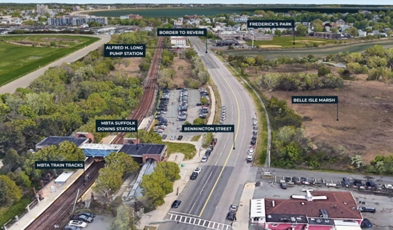
- The project is primarily located along Bennington Street in the East Boston neighborhood of the City of Boston (the segment between the MBTA Suffolk Downs Station to the Boston/Revere border) and Fredericks Park in the City of Revere. The project area also includes a privately owned VFW property to the west of Fredericks Park and residential properties to the east of Fredericks Park between the park and Montfern Avenue.
- What climate change impacts did the project address?
- Sea level rise, coastal flooding, and stormwater.
- What were the specific goals and tasks of the project?
- When the team submitted the FY24 MVP grant application, our stated goals included:
- Conduct a feasibility assessment of three alternatives to protect East Boston and Revere from the near- and long-term impacts of coastal flooding from sea-level rise and storms
- Advance the preferred alternative into further design development and permitting
- Redesign Fredericks Park to improve coastal resilience, stormwater management, recreation, and ecological habitat
- Evaluate and design co-benefits to be provided along Bennington Street, including coastal resilience infrastructure, green stormwater infrastructure, new tree canopy, and potential bicycle/pedestrian travel
- Ensure that all design alternatives support the health and longevity of Belle Isle Marsh
- When the team submitted the FY24 MVP grant application, our stated goals included:
- Did your project meet the goals:
- Employing nature-based solutions
- Yes, we evaluated nature-based solutions in our alternatives analysis and prioritized including gently-sloped berms/living levees around the project area to support potential marsh migration for Belle Isle Marsh, increased vegetation, and more previous surfaces.
- Improving equitable outcomes for and fostering strong partnerships with EJ and other Climate Vulnerable Populations
- Yes, we worked closely with the Friends of the Belle Isle Marsh and the Study of Belle Isle Marsh’s Community Advisory Group throughout the project. For our Public Information Session and Community Meeting for the project, we conducted outreach in English, Spanish, and Arabic, and provided translated meeting materials and live simultaneous interpretation.
- Providing regional benefits
- Yes, we only studied alternatives that would 1. reduce flood risk to the MBTA Blue Line, which is a regionally significant public transportation system; 2. reduce flood risk to Bennington Street, which is one of three evacuation routes serving East Boston, Revere, and Winthrop; and 3. enhancing Belle Isle Marsh by evaluating opportunities to support potential marsh migration so that the marsh can persevere in the future with sea level rise and continue to serve the region as a critical public recreational space.
- Implementing the public involvement and community engagement plan
- Yes, we implemented our public involvement and community engagement plan set forth in our application, which included a Public Information Session and a Community Meeting. We conducted outreach in multiple languages and through the channels we described in our application, provided all materials on our project website, and hosted a series of post-meeting follow-up opportunities (a “roadshow”) to continue the conversation with members of the public. We rescoped our grant, which involved adjusting our initially proposed community engagement plan by removing a second public meeting from the project’s scope. However, we added community engagement opportunities beyond our scope, such as tabling at a local festival, having meetings with members of the VFW, and attending nearly all of the FY24 Study of Belle Isle Marsh’s Community Advisory Group meetings.
- Finishing the project on time
- Yes, we completed our project, as outlined in our revised scope, on time!
- Employing nature-based solutions
Results and Deliverables
- Describe, and quantify (where possible) project results (e.g. square footage of habitat restored or created, increase in tree canopy coverage, etc.). Report out on the metrics outlined in your application.
- While we outlined a series of metrics in our application, this project, per the revised scope, concluded with a robust alternatives analysis to evaluate all potential coastal resilience options that would address coastal flooding in the project area and the permitting pathway associated with each. As a result, a selected strategy has not yet been identified and measurable outcomes cannot be determined at this time.
- Provide a brief summary of project deliverables with web links, if available.
- The final deliverable for this phase of the project is a Feasibility Report and Alternatives Analysis, which is a technical document that describes the study area’s existing conditions, the coastal flood risk, the alternatives analysis (including all evaluated options, screening criteria, and impacts), stakeholder and public involvement, a permitting analysis, cost estimates, and recommendations and next steps. It can be found on the project website.
Lessons Learned
- What lessons were learned as a result of the project?
- From a technical perspective, there were several lessons learned:
- For projects that need to conduct site investigations, geotechnical assessments, such as borings, need to be permitted prior to taking place and therefore must be factored into a project’s budget and timeline. For this project, this included approvals from the Boston and Revere Conservation Commissions, an MWRA 8(m) permit, and a Boston Public Works winter construction moratorium approval.
- Coastal resilience projects typically take place adjacent to wetland resource areas, which have strict and complicated permitting processes. While the State of MA’s environmental regulations are intended to preserve environmental resource areas, there are conflicts between these regulations and permitting nature-based solutions to address coastal flooding. Therefore, projects near or within wetland resource areas require flexibility in timelines to account for unknowns, deep alternatives analyses, and early conversations with regulatory agencies.
- Community engagement is important throughout a project’s development but there is a right time and place for engagement.
Different forms of engagement may vary from informing the community about a project to collecting community input on a project to educating the community about climate issues where they live. It is important to be intentional about the community engagement approach for a project so that feedback collection is meaningful and can be reflected in the project, and to ensure community engagement is additive and not extractive.
- From a technical perspective, there were several lessons learned:
- What is the best way for other communities to learn from your project/process?
- The best way for other communities to learn from our project/process is to read the final MVP report, reach out to the City of Boston and City of Revere directly with questions, and watch recordings from public meetings. Our project can provide a case study to other communities regarding developing coastal resilience strategies across multiple municipalities, evaluating coastal resilience strategies around/within wetland resource areas, working with State regulatory agencies early within a project’s development, conducting community engagement, and more.
Partners and Other Support
- City of Boston
- Environment Department: Catherine McCandless, Climate Resilience Project Manager, was the primary project lead who handled project
communication, logistics, grant administration and reporting, community engagement planning, alternatives analysis development, and more. Other staff in the department assisted in reviewing project materials, providing feedback, attending meetings, conducting community
engagement, and offering direction. - Boston Transportation Department / Boston Planning and Development Agency: Both departments weighed in regarding the future of Bennington Street as a transportation corridor and reviewed street section proposals/dimensions to ensure that space requirements would be met for both transportation and coastal resilience needs.
- Boston Conservation Commission: Staff from the Boston Conservation Commission provided feedback on the alternatives as they were being developed, attended site walks to review wetlands delineation, and attended meetings to provide insight from the local wetlands protection ordinance.
- Environment Department: Catherine McCandless, Climate Resilience Project Manager, was the primary project lead who handled project
- City of Revere
- Revere Parks & Recreation Department: Elle Baker, Open Space and Environmental Planner, was the co-project lead who worked on project communication, community engagement planning, alternatives analysis development, and more. Mike Hinojosa, the Director of Parks and recreation programming, identified the recreational needs in the project area to meet the needs of the growing population. Other staff from the Department (Frank Stringi and Tom Skiewarski) supported the team in reviewing project materials, providing feedback on the overall goals of the City for the restoration of this recreational space, and offering direction.
- Revere Department of Public Works was engaged to discuss the drainage and various scenarios presented.
- Revere Public Schools Department was engaged via the Beachmont Elementary School Principals and the City Lab High School to understand their current uses of the project area and their experiences regarding flooding. The Superintendent of the Revere Public School Maintenance has been in the role for decades and highlighted the experiences at the project site, such as damages to staff vehicles during floods, parking lot sinkage, insufficient drainage, and hazards to children during floods as they access the school
- Revere Conservation Commission: Staff from the Revere Conservation Commission provided feedback on the alternatives as they were being developed, attended site walks to review wetlands delineation, and attended meetings to provide insight on local wetlands protection.
- Consultant Team
- VHB: VHB was the primary consultant firm that led the project’s coastal modeling, coastal/civil/transportation engineering, permitting evaluation, alternatives analysis development, report writing, and more.
- Terraink Landscape Architecture: Terraink was a sub-consultant to VHB who led the project’s landscape design, primarily focusing on the redesign of Fredericks Park and creating visuals for the project.
- State of Massachusetts
- MA Department of Conservation and Recreation: Celeste De Palma, Climate Resilience Program Coordinator, attended all project meetings and worked closely with the project team throughout the project to provide feedback and weigh in as the alternatives analysis progressed. Celeste was assisted by Sarah White, Jorge Ayb, Sean Riley, and others at DCR who offered feedback and input on the possible alternatives. Celeste also participates in the Study of Belle Isle Marsh’s Stakeholder Collaborative and has advised on the Morton Street project in Winthrop.
- MA Department of Transportation: Michael Trepanier and Hung Pham worked closely with the project team regarding the future of Bennington Street as a transportation corridor and reviewed street section proposals/dimensions to ensure that space requirements would be met for both transportation and coastal resilience needs. Michael and Hung also participate in the Study of Belle Isle Marsh’s Stakeholder Collaborative and have provided advice regarding transportation project funding.
- MA Office of Coastal Zone Management: Staff from CZM have met with the project team on four occasions throughout the project to advise on potential coastal resilience strategies and permitting implications.
- MA Department of Environmental Protection: Staff from DEP have met with the project team on four occasions throughout the project to advise on potential coastal resilience strategies and permitting implications.
- East Boston and Revere Community
- VFW Members: The City of Revere met with members of the VFW on-site to provide an overview of the project and better understand the VFW’s use of the parking lot. The City learned that the VFW is currently renting parking spaces to generate income for the facility and that the owner of the cell tower, MetroPCS, purchased the small square of property to install the cell tower. This infrastructure generates a payment of $20,000 to the VFW annually for another 3 years. The VFW members raised concerns that any encroachment to the parking lot could contribute to a revenue loss for the facility and shared the flooding they have experienced in the parking lot as a result of stormwater.
- Friends of the Belle Isle Marsh and Community Advisory Group: As mentioned previously, the project team engaged with FBIM and the CAG associated with the Study of Belle Isle Marsh throughout the project to share updates, collect feedback, and strategize on community engagement, when appropriate.
- Broader Public: The project team is grateful for the participation by members of the public from East Boston, Revere, and beyond who
attended the November 2023 Public Information Session, the May 2024 Community Meeting, and the two virtual office hours and in-person
coffee hour to ask questions and share feedback.