
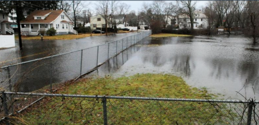
Sycamore/Belmont Intersection, January 13,2018
Project Details
Project Title
Integrated Water Infrastructure Vulnerability Assessment for Climate Resiliency
Municipality
Brockton
MVP Region
Southeast
Award Year
FY2019
Grant Award
$294,698
Project Length
One Year; extended due to COVID
Community Overview
- Brockton is located in Plymouth County, Massachusetts. The City prides itself on its diversity of cultures, and is home to approximately 100,000 residents.
- Almost the entire City of Brockton is mapped as an Environmental Justice community. Brockton has significant and diverse minority populations, as well as several areas of the community which are also low-income and/or linguistically isolated. Brockton’s practice is to translate materials into four main languages spoken in the City: English, Spanish, Haitian Creole, and Cape Verdean Creole.
- Present day Brockton was first settled in the 17th century and was originally known as North Bridgewater – a geographic area that is today comprised of the communities of Brockton, West Bridgewater, East Bridgewater, and Bridgewater. Brockton became a city in 1881. Farms gave way to factories, and Brockton became an epicenter of the shoe and textile industries, earning the name “Shoe City.” At the dawn of the 20th century, the City had a population of 40,000; and more than 6,000 people were employed in over 100 separate shoe manufacturing entities. Named one of the Best Communities for Young People three times (2010, 2008, and 2005), Brockton is home to an award-winning public school system. Brockton High School, the largest high school in New England and one of the biggest in the nation, has more than 4,200 students and has twice been named one of America’s Best High School’s by U.S. News & World Report.
Project Description and Goals
- Where was the project located?
- The City’s MVP Project focused on the primary waterways in the City: Salisbury Brook, Salisbury Plain River, and Trout Brook.
- What climate change impacts did the project address?
- Inland Flooding.
- What were the specific goals and tasks of the project?
- The primary goal of this project was to conduct a study that would develop an accurate understanding of risks to infrastructure, environment, and residents resulting from flooding events in the City and to identify solutions to address those risks and increase flood resiliency along Salisbury Brook and the Salisbury Plain River. Specific tasks included:
- Development of hydraulic modeling of the river system in HEC-RAS.
- Assessment of risks to public infrastructure and private development within the river’s current and projected floodplains.
- Development of a prioritization tool to help identify those structures and areas most in need of protection.
- Modeling of various potential nature-based solutions for flood reduction along Salisbury Brook and the Salisbury Plain River
- Dredging and ecological enhancement of Ellis Brett Pond
- Dredging and ecological enhancement of Cross Pond
- Restoration of undeveloped parcels in the floodplain
- Buy-out and restoration of developed sites within the floodplain
- Assessment of green infrastructure alternatives to address downstream flooding by reducing runoff volumes at Westgate Mall
- Modeling of nature-based solutions for flood reduction along Trout Brook (this task was added during the grant to use funds that had originally been allocated to investigating additional (traditional) flood protection alternatives)
- The primary goal of this project was to conduct a study that would develop an accurate understanding of risks to infrastructure, environment, and residents resulting from flooding events in the City and to identify solutions to address those risks and increase flood resiliency along Salisbury Brook and the Salisbury Plain River. Specific tasks included:
- Did your project meet the goals:
- The project has met all of the goals set forth in the City’s grant application in terms of:
- Employing nature-based solutions
- A recommended nature-based approach was identified to reduce flooding along Salisbury Brook and the Salisbury Plain River that includes the following:
- Utilizing the Ellis Brett Pond Dam, to hold additional water during storm events and control its release.
- Applying floodplain restoration approaches that excavate key properties along the river corridor to create additional floodplain storage where Salisbury Plain River is currently restricted by channelized banks and/or development within the floodplain.
- Along Trout Brook, a recommended nature-based solution was identified that includes creation of a broad, restored riparian corridor along Trout Brook as part of the redevelopment of an abandoned CSX railyard that is currently bisected by the brook. The resiliency improvements along the brook will reconnect Trout Brook with its historic floodplain through the former CSX railyard and downstream of Court Street where a culverted section of the brook is also proposed to be daylighted and reconnected to floodplain on adjacent City property. As part of the solution, the capacity of an undersized culvert at Court Street would also be increased, and selected residential properties along the brook that have experienced repetitive losses would be acquired to further enhance flood storage capacity.
- A recommended nature-based approach was identified to reduce flooding along Salisbury Brook and the Salisbury Plain River that includes the following:
- Improving equitable outcomes for, and fostering strong partnerships with, EJ and other Climate Vulnerable Populations
- As noted above, almost the entire City of Brockton is mapped as part of an Environmental Justice Community. Flood reductions from the nature based solutions identified through this project would have significant benefit for low-income and minority populations. To help reach a wide audience with information about flood prone areas and climate risks, as well as the proposed solutions identified through the project, the executive summary was translated into Brockton’s four main languages: English, Spanish, Haitian Creole, and Cape Verdean Creole.
- Providing regional benefits
- From the onset of the project, Brockton recognized that moving water through the City faster, while it might alleviate some flooding concerns, would only cause greater impacts for downstream communities like West Bridgewater. The overall project focus was therefore on slowing and infiltrating water higher up in the watershed, working with nature-based solutions to limit downstream flooding impacts. The solutions identified through this project will do exactly that, with benefits for Brockton’s downstream neighbors as well as the City’s own residents and businesses.
- Implementing the public involvement and community engagement plan set forth in your application
- Early in the project, Brockton held a public information session to gather feedback on known areas of flooding and ask the public to confirm the inundation areas predicted by the hydraulic models, and also to weigh in on the risk assessments and provide feedback on the tentative scoring of different buildings and neighborhoods. Additional input from the public helped shape which areas and buildings were rated as higher risk and focus the targeted areas for protection with nature-based solutions.
- The outreach strategy was transitioned to a digital focus later in the project to accommodate COVID restrictions. A project website was set up as a clearinghouse for project information. Key project results were compiled into an executive summary and translated into Spanish, Cape Verdean Creole, and Haitian Creole. These versions were all posted along with the English language version on the project website.
- The City also connected with the Brockton High School Envirothon team. Both City staff and the City’s consultants independently met with the students to discuss the project and talk with students about how they can get involved with community outreach. The Envirothon Team completed a public service announcement video as part of their work.
- Finishing the project on time
- The project was extended due to the impacts of COVID, which slowed down the City’s progress for several months. Under the terms of the extension, all project deliverables were completed on time and on budget.
- Employing nature-based solutions
- The project has met all of the goals set forth in the City’s grant application in terms of:
Results and Deliverables
- Describe, and quantify (where possible) project results (e.g. square footage of habitat restored or created, increase in tree canopy coverage, etc.). Report out on the metrics outlined in your application.
- Based on modeling results, the nature-based solutions identified for Salisbury Brook and Salisbury Plain River will yield additional flood storage at key points in the river system, resulting in up to 18-inch reductions in flood elevations during more frequent flood events. Significant benefits are seen throughout the length of the river during the 2 year and 10-year floods, and several bridges are protected from overtopping during the 10-year flood. This alternative also provides flood reduction benefits throughout the river system for the 50-year flood, including protection of the White Avenue Bridge crossing from overtopping during that event. The downstream floodplain restoration work provides additional protection for commercial properties at the south end of the City, adding significant additional benefit between Pine Ave. and Sargent’s Way for the 10-year through 500-year storm events relative to inclusion of the Ellis Brett components alone.
- At Trout Brook, the collective improvements proposed will increase flood capacity by creating a floodable green space that provides additional flood storage capacity in the immediate vicinity of the CSX railyard as well as in upstream and downstream areas where known repetitive flooding losses have occurred. Areas of the CSX railyard which are currently within the floodplain will be removed from the 100-year floodplain and protected for redevelopment. Downstream areas including significant commercial (Verizon, Evans Machine Co.), institutional (Haitian Assembly of God of Brockton), and residential properties will also be removed from the 100-year floodplain. The flood resiliency project will also allow for creation of a walkable green corridor to create continuous public green space along the brook as a public amenity, providing the community with both a nature-based solution to safely store water during flood events and enhance connectivity and walkable access to recreation opportunities within the surrounding neighborhoods.
- Provide a brief summary of project deliverables with web links, if available.
- Key project deliverables include the executive summary and overall project report on Nature-Based Solutions for Flood Resiliency for Salisbury Brook & Salisbury Plain River, as well as the separate summary and report for Nature-Based Solutions for Flood Resiliency for Trout Brook. The executive summary and translated versions will remain available for easy access on the project webpage.
Lessons Learned
- What lessons were learned as a result of the project?
- Hydraulic modeling of the river system proved to be a powerful tool for Brockton to explore different approaches to flood resiliency. Many people had their own ideas and theories about the source of the problem and where action would be needed to help address the flooding. Some of those theories were borne out by the modeling and others were not—so the models helped to give real direction to guide where future attention should be focused.
- Project buy-in and leadership is crucial to a successful project. Numerous staff transitions and turnover following the untimely death of Mayor Carpenter just before the beginning of the project at times left the project team without clear direction. The impacts of COVID further complicated things, as staff time was drawn in many unexpected directions, and the project duration stretched from a one-year project into two-years.
- Coordinating with the Mayor’s office and City Council to make a presentation of the project and widen the audience involved in the decision-making took much longer than expected, and the presentation was delayed several months.
- What is the best way for other communities to learn from your project/process?
- See the project website.
Partners and Other Support
Our two main partners were the Town of Braintree Engineering Division and Nitsch Engineering.
- City of Brockton Project Team
- Chike Odunukwe, P.E., City Engineer
- Larry Rowley, DPW Commissioner
- Rob May, CEcD, Director of Planning and Economic Development
- Megan Shave, PhD, Conservation Agent and Planner o Troy Clarkson, CFO
- Paul Umano (formerly the Grants Coordinator in Mayor Carpenter’s Office)
- City IT Department
- Fuss & O’Neill – Engineering Consultant Team
- Julianne Busa, PhD, Project Manager
- Sean Arruda, PE, CFM, Hydraulic Modeling
- Dean Audet, PE, Technical Lead o Liz Isenstein, MSc, EIT, Hydraulic Modeling
- Nelson Tull, EIT, Hydraulic Modeling
- Sarah Hayden, MSc, MBA, Risk Assessment & Prioritization o Arnold Robinson, AICP, WEDG, Community Engagement
- Nina Morelli, PLA, Landscape Architect/Graphics
- Stephanie White, PLA, Landscape Architect/Graphics
- Mark Pereira, PE, CFM, Cost Benefit Analysis