Project Background
DCR is planning a complete renovation of Draw Seven Park, in the Mystic River Reservation. The park currently consists mainly of highly degraded lawn/playing field, a degraded shoreline, and a few amenities: river path, fish pier, parking lot, and benches, and provides access to the Amelia Earhart (AE) Dam. In order to meet the key goals, the entire site will be reconstructed.
The five key goals for this project
- Connectivity
- Recreation
- Ecological/habitat restoration
- Climate resiliency/flood protection
- Upgraded AE Dam utilities
In keeping with the Mystic River Reservation Master Plan, public meeting feedback, and the above-noted goals, the project includes the following elements:
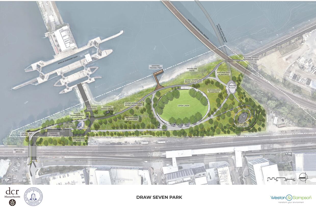
- Multiple connections: links to both the new Draw Seven Park Path Extension (to Alford St. Charlestown), the proposed Mystic River Crossing pedestrian/bicycle bridge to Everett, and to the entire Mystic River Reservation.
- Passive recreation (informal field play, picnicking, nature exploration and interpretation, trails)
- Improved the habitat and ecology of the riverbank and upland: this includes a significant “living shoreline”, with salt-tolerant plants inhabiting a more natural gradient on the bank above the coastal beach, on the tidal side of the AE Dam; large areas of meadow (drier and wetter), woodland areas, including the buffer along the Orange Line tracks, and storm water infiltration throughout; large numbers of tree plantings throughout.
- Significant climate resiliency and flood protection will be provided by both the living shoreline, and the raising of elevations in the park, which will form a bowl configuration from the AE dam, westward to and along the Orange Line tracks, and connecting with the commuter rail embankment. This landform will provide major flood protection, in coordination with the current plans for the AE Dam hardening and raising, for Somerville and communities beyond. (See below for more information on how this project addresses climate change.)
- AE Dam utility upgrades: Water and sewer lines currently run under the Orange Line tracks. The water line has been leaking for some years in multiple locations. The park renovation offers an opportunity to realign the utilities under the park entry road, and replace the old with new, reliable systems. Electrical service will also be upgraded (and be placed underground), with the installation of a new transformer pad and conduit up to the dam gallery.
Additional Resources
-
Open PDF file, 6.91 MB, Mystic River Master Plan (English, PDF 6.91 MB)
Public Outreach
Draw 7 Park Renovation Design Review Public Meeting 11/16/2023
Thursday, November 16, 2023
6 p.m. - 7:30 p.m.
This project began in spring of 2017, and the first schematic presentation to the public, in Feb. 2018, included an option which has since been abandoned (a formal athletic field). A more recent public presentation of the 25% design occurred on Feb. 25, 2020. Draw Seven Presentation
The design has evolved somewhat from that time, per the illustrative plan below.
Additional Resources
-
Open PDF file, 6.33 MB, Draw Seven Design 9.22.2023 (English, PDF 6.33 MB)
-
Open PDF file, 7.39 MB, Draw Seven Park Design Construction Plans – selected sheets (English, PDF 7.39 MB)
-
Open PDF file, 1.46 MB, Draw Seven Trail Detour (English, PDF 1.46 MB)
Partner Collaboration
- MyWRA contributed funds through the Partnership Program to supplement the design of the living shoreline.
- The City of Somerville promoted and assisted DCR with the LWCF Grant application, as well as committed to a contribution of $250,000 toward the $1,000,000 needed to be spent on design and construction, for 50% reimbursement eligibility for the $500,000 grant.
Permits
- The following permits are needed for the project:
NOI, Ch 91, DEP 401 WQC, ENF, MWRA 8(m), CZM review, MEPA Review, ACOE General Permit, and a Dam Safety permit.
- An early action Notice of Intent for a partial removal of an existing old fuel line was approved by the Somerville Conservation Commission, and the work completed.
Time Schedule
- 100% construction documents fall 2023
- Permits in review and being submitted to multiple agencies: Summer-fall 2023
- Construction start late summer 2024
- Construction completion is expected in 2026.
Addressing Climate Change
Draw Seven Park has been designed to anticipate impacts from climate change. The proposed park grading and layout will work in concert with the hardening of the Amelia Earhart Dam to protect critical infrastructure from flooding. Climate strategies for mitigation include:
- Relocation of critical infrastructure: The replacement design for AE Dam utilities within the park will also address climate resiliency and maintenance access. The utilities will be placed underground, for both practical and aesthetic reasons, however, they will be located at higher elevations. In addition, DCR is raising the vault walls for the MWRA gate valve by four feet. The new AE Dam transformer will be placed on a concrete pad four feet higher than the existing one.
- Flood barriers: Flood barriers are not required along Artisan Way/ Noonan Place under the MBTA line because the raised grade elevations in the park itself provide an extension of the AE Dam future raised elevation, and provide the flood barrier.
- Increased stormwater infiltration: Although the imperious paving in the park will be increased to provide accessible routes for visitors where currently there are no paths, bioretention basins are being added to the park project to infiltrate and filter stormwater runoff. The stormwater management areas total 30,500 sf. In addition, plus stormwater storage chambers will be located underneath the parking lot. Moreover, the site’s severely compacted soils will be completely removed and replaced with well-draining soils and large areas of native plantings which will increase stormwater infiltration and uptake in the parkland.
- Elevate infrastructure: See above.
- Living shoreline and other nature based solutions: The bioretention basins are described above. Downstream of the dam, the project shoreline includes 360 LF and an area of 36,600 SF of living shoreline, increasing the habitat value of the riverbank.
- Increased tree canopy: Although there will be a few tree removals to raise the grade of the park as part of the hardening project, the landscape plan includes 284 new trees, 8 new shrubs, 943 ground cover plants, and 110,000 sf, or 2.5 acres of meadow planting.
- Greenhouse gas emission reductions: The reconstructed shared-use trail will connect the Mystic River Greenway to Boston and the North Shore, becoming an important green transportation route and reduce SOV commuter trips. In addition, with easy access from the MBTA Orange Line and the Greenway, it is anticipated that park visitors will not use car trips to access the park, and the parking lot was sized accordingly.