Introduction
MassGIS initiated a Massachusetts geospatial strategic planning effort in January 2024. As part of the strategic planning effort, six workshops were held across Massachusetts. The workshop locations were selected to allow geospatial stakeholders across the state to participate in the strategic planning effort. The workshops were held in Andover, Boston, Springfield, Pittsfield, Wareham, and Worcester. Workshops were conducted to gather information from GIS professionals and other users of geospatial data or services. This report summarizes the workshop findings. The workshop findings will be used in developing strategic plan elements.
Description of Workshops
The same activities were used in each of the six three-hour workshops. The workshops were guided by a series of electronic slides (Appendix A). The general agenda was:
- Team introductions
- Brief overview of strategic planning
- Agenda review
- Summary of strategic planning on-line survey (conducted January and February 2024)
- Discussion of the Massachusetts Geospatial Information Coordinating Council (MaGICC)
- Breakout Session #1 – Categorizing ideas about MaGICC outcomes
- Breakout Session #2 – Ensuring MaGICC represents stakeholder needs
- Breakout Session #3 – Actions and activities to benefit the Massachusetts geospatial community
- Review of Session #1 results
- Open discussion
- Closing
Participants were placed in groups of four to five people. Stakeholders with the same interests or employer were intentionally spread across groups. Diversity in group membership promoted discussion and consideration of stakeholder needs broadly rather than just those in one line of work. Each group performed each of the breakout session activities. The breakout sessions are detailed below:
Breakout Session #1: Importance and Urgency of Possible MaGICC Topics
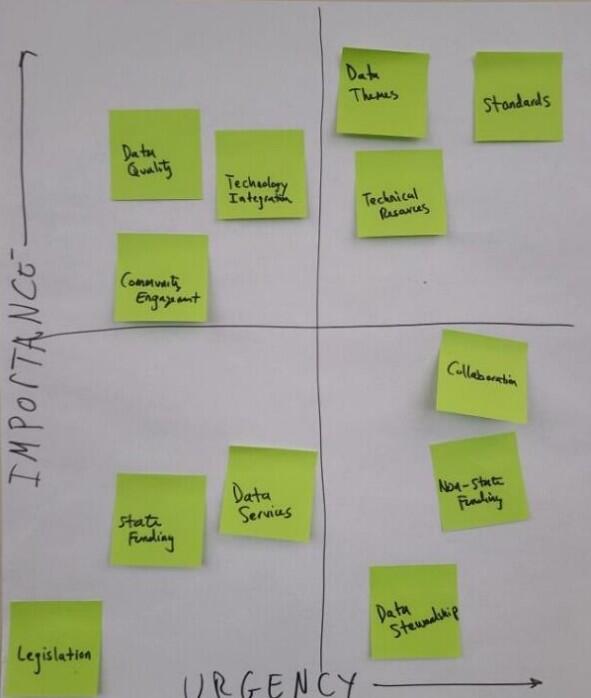
Breakout Session #1 asked each group to evaluate 12 outcomes that the Massachusetts Geospatial Information Coordinating Council could seek to achieve in terms of urgency and importance. This was phrased as a question: “What outcomes should the MaGICC council seek?” The same 12 outcomes were provided to each group on adhesive notes:
- Data Themes: Defined Core Data Content of the MA Spatial Data Infrastructure (Themes in the MSDI)
- Data Services: Defined Core Data Services (web maps, services) of the MSDI
- Data Stewardship: Established Data Stewardship Roles
- Technical Resources: Supply Additional Technical Resources to Local Governments
- Standards: Defined Statewide policies, standards and best practices around authoritative datasets
- State Funding: Established sustainable funding for GIS in state government
- Non-State Funding: Established sustainable funding for GIS in other (non-state) government
- Community Engagement: Enhanced and sustainable Massachusetts’ geospatial stakeholder community
- Legislation: Seek to have legislation concerning geospatial data
- Technology Integration: Integrated geospatial technologies and data throughout State and local government
- Data Quality: Seek to have mechanisms for ensuring SDI has high data quality
- Collaboration: Improved and expanded coordination and collaboration
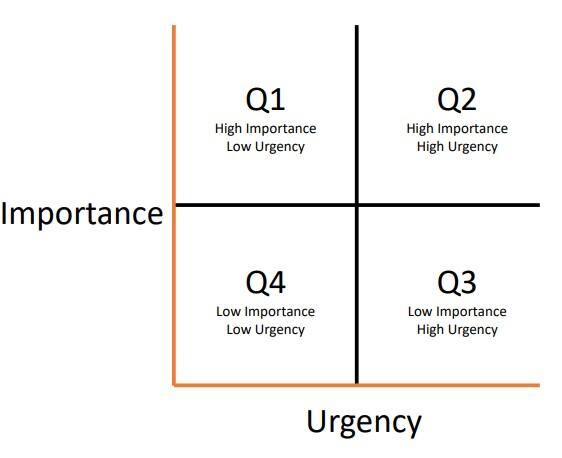
Groups then took each adhesive note and determined as a team where it should be placed on an urgency vs. importance chart (Figure 1). Groups were asked to select three of the 12 topics to place in each quadrant of the chart (Figure 2). This required each group to consider how they would rank each outcome on two scales. This provoked a lot of discussion in most groups. All group quadrant charts were then tallied for the entire workshop and shown to attendees just before the workshop wrap-up discussion.
Figure 1. Importance vs. Urgency chart used in Breakout Session #1.
Breakout Session #2: Ensuring MaGICC Represents Stakeholder Needs
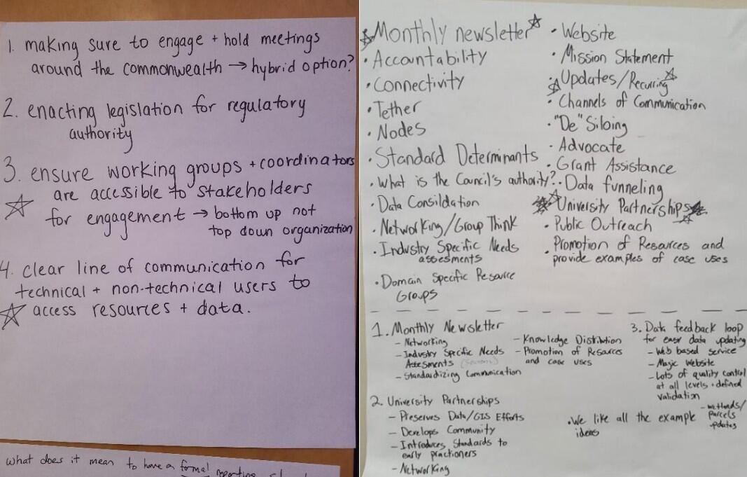
Breakout Session #2 asked each group to answer the question “How do we ensure MaGICC represents stakeholder needs?” Groups were asked to write down ideas. They were then asked to assign priorities to their ideas (Figure 3). A spokesperson for each group presented the group’s top two ideas to the workshop.
Breakout Session #3: Activities to Enhance the Geospatial Community
Breakout Session #3 asked each group to devise ideas for actions or activities that would benefit the Massachusetts geospatial community. Note that in the previous breakout session, groups were asked what MaGICC should do, but in this session, they were asked about actions that could be taken by anyone to benefit everyone. Groups were asked to estimate whether an idea would take one year, three years, or five years to implement (Figure 4). Each group presented their most important idea to the workshop attendees. Workshop attendees were then asked to vote for their two favorite ideas.
Six three-hour workshops were held throughout the Commonwealth, as noted earlier. Attendance varied from workshop to workshop, but in all, 130 people attended the workshops.
Table 1: Workshop dates, locations, and number of participants
| Date | Location | Number of Participants |
|---|---|---|
| 2/21/2024 | Pittsfield, Massachusetts | 6 |
| 2/22/2024 | Springfield, Massachusetts | 18 |
| 2/27/2024 | Wareham, Massachusetts | 21 |
| 2/28/2024 | Worcester, Massachusetts | 24 |
| 3/5/2024 | Boston, Massachusetts | 43 |
| 3/7/2024 | Andover, Massachusetts | 18 |
| Total | 130 |
Workshop Findings
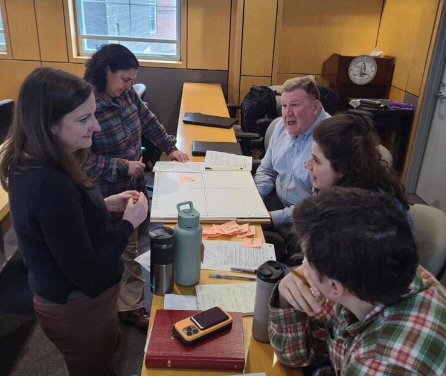
Participants at the workshops were engaged and actively contributing to their groups in each breakout session (Figure 5). Geospatial data and technologies have become widespread, so there was a wide variety of ideas expressed. The workshop breakout sessions, however, were designed to promote participants to choose between good ideas or actions; otherwise, it would be very difficult to find the most popular or best ideas and proposed actions. This section discusses the overall outcome of each breakout session.
Breakout Session #1: Importance and Urgency of Possible MaGICC Topics
In this session, groups of participants were asked to determine which topics MaGICC should consider most and least important, and most and least urgent (Figure 1). Table 2 shows the results of the categorization.
Table 2. Breakout Session #1 categorizations of 12 MaGICC topics by 27 workshop participant groups.
| Topic | High Importance High Urgency | High Importance Low Urgency | Low Importance High Urgency | Low Importance Low Urgency | Total | % High Importance | % High Urgency |
|---|---|---|---|---|---|---|---|
| Data Quality | 13 | 11 | 2 | 1 | 27 | 89 | 56 |
| Standards | 12 | 11 | 4 | 0 | 27 | 85 | 59 |
| State Funding | 12 | 8 | 3 | 4 | 27 | 74 | 56 |
| Data Services | 11 | 4 | 4 | 8 | 27 | 56 | 56 |
| Non-State Funding | 8 | 6 | 7 | 6 | 27 | 52 | 56 |
| Data Themes | 7 | 6 | 3 | 11 | 27 | 48 | 37 |
| Data Stewardship | 5 | 5 | 12 | 5 | 27 | 37 | 63 |
| Technology Integration | 5 | 8 | 4 | 10 | 27 | 48 | 33 |
| Community Engagement | 4 | 6 | 11 | 6 | 27 | 37 | 56 |
| Technical Resources | 3 | 6 | 9 | 9 | 27 | 33 | 44 |
| Collaboration | 3 | 8 | 12 | 4 | 27 | 41 | 56 |
| Legislation | 2 | 6 | 4 | 15 | 27 | 30 | 22 |
These results are shown in chart form in Figure 6:
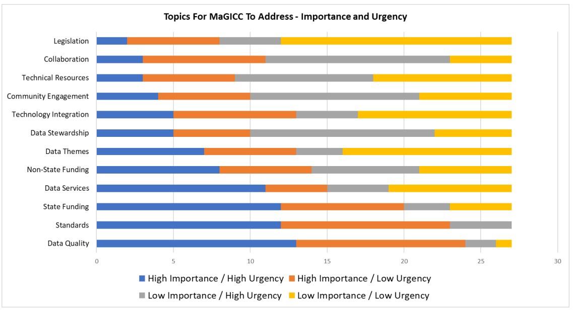
The results of Breakout Session #1 show several interesting trends for outcomes that MaGICC should seek to achieve. Unsurprisingly, data tends to be highly important (Table 2, % High Importance column; Figure 6, blue and orange chart segments). Data quality is the most important outcome the groups want, whether that is urgent (blue bar segment) or not (orange bar segment). Standards and data services are also quite important. Funding, especially funding at the state level, is also quite important. In terms of urgency, the most urgent outcome sought from MaGICC is data stewardship.
Breakout Session #1 revealed the following about the topics MaGICC should address or outcomes the Council should seek to achieve:
- Most Important:
- Data characteristics (quality, standards, services)
- State funding
- Least Important:
- Technical resources, i.e., availability of technical resources
- Legislation
- Most Urgent:
- Data stewardship
- Least Urgent:
- Technology integration (e.g., with major private sector geospatial services)
- Legislation
Data and data governance are important topics for MaGICC to address, based on this session’s results. Participants did not think legislation was very important for MaGICC to take up. However, legislative authority that establishes some authority and guidance functions in MaGICC would be needed by MaGICC to achieve some outcomes that are important and urgent. For example, data governance such as stewardship, building standards, and defining authoritative data quality all presume that MaGICC has the legislative brief to take on these issues. If state funding, in some form, is managed by the Council, then that may also require or benefit from legislation that defines the Council’s role in managing state funds.
Collaboration and Community Engagement are MaGICC outcomes or achievements also implied by the results of this exercise, since data governance, standards, stewardship, and authority are likely to be collaborations involving the geospatial community. Although they are not ranked as important as data related outcomes they are ranked highly in urgency. The most important and most urgent outcomes will necessitate bringing together technical and fiscal stakeholders (i.e., MaGICC coordination) to achieve.
Breakout Session #2: Ensuring MaGICC Represents Stakeholder Needs
In this activity, the participants put forth ideas about actions and activities that MaGICC should take or perform in order to represent stakeholder needs. The 54 ideas (two per group) were evaluated for trends and common statements.
The summary, provided in bullet lists below, tries to capture the most common threads of those ideas and stating them in a form that is easy to act upon. These can be encapsulated in four major categories: council composition, communications, activities, and other considerations or guidelines. Ideas presented in each category are listed in bullets below:
- The Council should be composed of diverse interests and sectors:
- The composition of the council would be stronger if it included a legislator or at least a liaison to a legislator.
- Legislation enforcing / emphasizing the purpose and formalizing the Council in law would make it much stronger.
- Consider having seats that are filled by stakeholder sectors, perhaps by formal election from those sectors.
- Regional diversity is very important in Council representatives and in making sure that all Council members understand the Commonwealth’s diversity in order to make decisions that are not driven by regions or interests that are in the forefront of geospatial use.
- The Council must be an active body for stakeholder interests:
- Seek funding for local and regional progress to support statewide products and progress.
- Advocate for the importance of geospatial data use and the need to invest in it.
- Promote partnerships between stakeholders, including industry and educational organizations.
- Be an event creator: workshops, trainings, etc.
- The Council must be highly communicative:
- Communicate in multiple modes and through many channels.
- Meetings in various locations throughout Massachusetts, virtually and in person.
- Events: workshops and conferences (or gatherings at other conferences)
- Publish: social media, web site, and give insight via blogging or less formal statements.
- Make it easy for stakeholders to “talk back”
- Consider having council liaisons to specific stakeholder sectors.
- Form working groups of stakeholders (specific topics) so that stakeholders are part of Council processes directly.
- Make it easy for technical and non-technical stakeholders (data producers vs. data consumers) to communicate what Council should consider on their behalf.
- General considerations for the Council:
- The Council should be the locus of collaborative governance for geospatial data and technologies, bringing public and private stakeholders together with public agencies for consensus-based decision making.
- Make sure that the Council strives to engage “historically underserved” communities.
- Different regions of Massachusetts have quite different needs. Consider communities that might have few resources, not just those that have (and use) considerable resources in using geospatial data and services.
Workshop participants had many ideas for how MaGICC should represent stakeholder interests. The group and workshop discussions that were part of this breakout session all very clearly showed that participants want MaGICC to be a highly active and influential entity. Participants were excited about a council that represents and takes (or promotes) actions on their behalf.
Breakout Session #3: Activities to Enhance the Geospatial Community
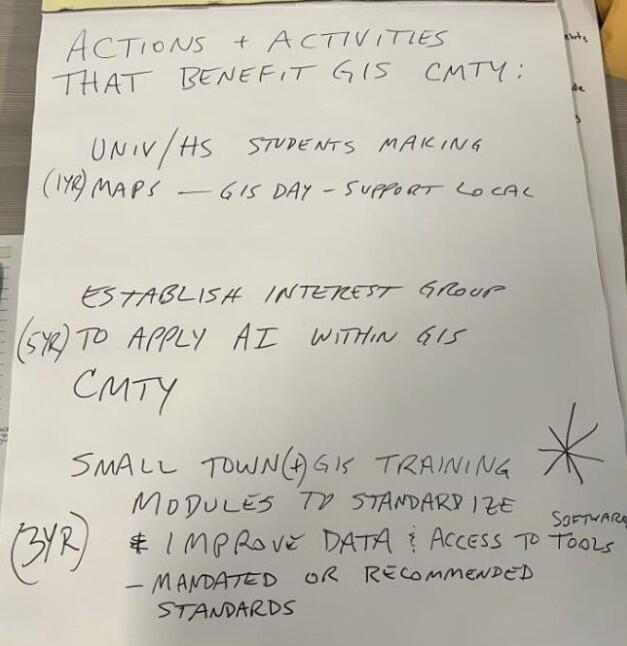
In Breakout Session #3, the groups were asked to devise ideas about actions that would enhance the geospatial community. Unlike the two earlier breakout sessions, the ideas were not specific to MaGICC. The groups were asked to propose feasible actions: possible to accomplish, with clearly stated outcomes, and timelines of one, three or five years.
Ideas were reviewed in groups, then presented to all participants and voted upon. The ideas that were accepted fall into 5 themes. Each theme is listed below with a bullet list of specific ideas in that theme:
- Stakeholders are looking for more collaboration at every level (peer to peer, between state and local government, among public agencies):
- Online “hub” that serves as a user community forum for announcements, data updates, questions, sharing of tips/best practices, etc.
- Self-service statewide directory of GIS professionals
- Regularly occurring community meetings and state conferences
- Regional network of connected agencies, across all sectors of government, that share data and resources
- Stakeholders want access to more resources (tools, technologies, etc.) and more guidance:
- Partnerships with universities to provide training to students and support to local entities lacking GIS capabilities/ staff capacity
- “Training models” for municipalities to standardize data and use of GIS tools
- IT resources (a subcommittee of MaGICC / extension of MassGIS/ other office) to offer guidance and training, particularly to smaller local orgs with less GIS resources
- More resources to use/ learn about open source tools o Crowd-sourced data collection
- Crowd-sourced data collection
- Stakeholders want to elevate the degree of GIS literacy across the state (including through workforce development):
- Training for high school and university students who then offer GIS support to local entities
- GIS “showcase” for state legislators and local decision-makers
- Learning opportunities at public facilities (libraries, schools, public/ senior centers, etc.)
- Stakeholders need an expanded pipeline to a state data repository that aggregates, houses, and shares their authoritative data
- Provide a data sharing platform that:
- Provides local subject matter experts with an opportunity (access and technology) to review/update data created or aggregated by the state
- Provide local subject matter experts a location to host their authoritative data about their local jurisdiction
- Capability to submit feedback/ corrections to datasets in MassMapper
- Stakeholders statewide would welcome funding for entities with less resources (especially local):
- Funds devoted to towns and COGs
- Cost-sharing opportunities for important datasets
- Legislative funding for recurring annual grants for data acquisition i.e. imagery, statewide layers
Many of the themes and ideas documented in Breakout Session #3 reflect participants’ desire for an active technical "hub” that would serve as a bulletin board for peer exchange, centralize data resources from Commonwealth agencies and from local governments, and serve as a coordinating entity for collaboration, training, and education. These are all roles that MassGIS has taken on historically, so one way to interpret these themes is that stakeholders want MassGIS (or MaGICC) to be even more active in taking these actions.
Other ideas brought forward in the work done by the participants involve more funding for geospatial data development and maintenance, and more partnerships with educational institutions including secondary schools in the Commonwealth. These themes support or may even be prerequisites to some of the “hub” themes. For example, raising geospatial literacy through partnering with educational bodies (especially high schools) increases the public understanding of why geospatial data and services are important, and how they need funding to be maintained and expanded.
Conclusion
The six workshops conducted as part of the 2024 strategic planning study were very successful. Massachusetts has a very active professional geospatial community who want their work to be even more valuable to the Commonwealth, local governments, and the public. The 130 participants in the workshops want MaGICC and MassGIS to be partners with them in advancing geospatial services and data for all stakeholders. They also want Massachusetts to grow as a GIS community of practice, with more peer-to-peer communication, co-education, and sharing data or technical resources.
List of Appendices
Appendix A: Workshop Slide Deck
Appendix B: List of Workshop Attendees
Appendix C: Breakout Session Summaries
Activity 1 Workshop Activity Graphs.xlsx
Activity 2.xlsx
Activity 3 Summary.docx
| Last updated: | August 14, 2025 |
|---|