
Logos of Sanborn, MassGIS and EOTSS
Today’s Facilitators

Sanborn staff:
- Michele Giorgianni - Principal in Charge
- Peter Lemack Senior - Project Manager
- Priya Sankalia - Business Analyst
The MassGIS Team

MassGIS Staff:
- Cy Smith - State GIO & MassGIS Director
- Aleda Freeman - Web Mapping Services Manager
- Michael Trust - Senior GIS Database Administrator
- Paul Nutting - Stakeholder Support
- Peter Grace - Senior GIS Analyst
Today's Agenda
- Part 1: Introduction, Agenda, Survey Summary, MaGICC 9am – 9:30am
Part 2: Breakout Session #1 9:30am – 10:10am
Break: 10:10am - 10:20am
- Part 3: Breakout Session #2 10:20am -11:05am
- Part 4: Breakout Session #3 11:05 – 11:50am
- Part 5: Conclusion 11:50am - Noon
Massachusetts Geospatial Strategy
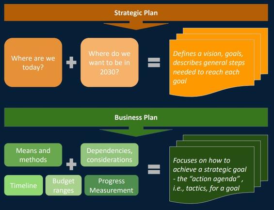
Strategic Plan:
Where are we today? + Where do we want to be in 2030? = Defines a vision, goals, describes general steps needed to reach each goal
Business Plan:
Means and methods + Dependencies, considerations + Timeline + Budget ranges + Progress Measurement = Focuses on how to achieve a strategic goal - the “action agenda” , i.e., tactics, for a goal
Workshop Goals
- Engage with the Massachusetts Geospatial Community
- Collect your ideas and recommendations for increasing geospatial maturity across the state
- Understand your priorities and directions for the geospatial strategic plan
- Share the results from the Strategic Plan Survey
MA Geospatial Information Coordinating Council (MaGICC)
MaGICC will provide statewide governance for sharing, coordinating, and managing the Massachusetts spatial data infrastructure (Mass SDI).
Mass SDI includes geospatial data and the technology, people, policies, standards and processes necessary to share and manage that data
MaGICC Goals:
- Enhance coordination among public bodies with respect to geospatial data
- Support consistent provision of government services across the Commonwealth
- Improve geospatial data sharing among public bodies
- Support the improved economic and social wellbeing of the state
MaGICC will implement, or provide oversight for, much of what is contained in the Strategy
Survey Summary
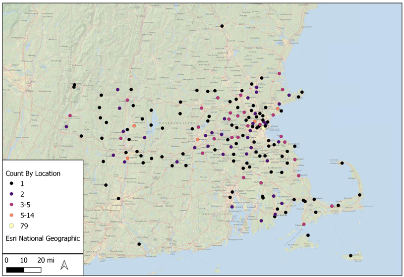
Participant Distribution
The strategic planning initiative began with a survey seeking initial feedback on direction and improvements from all geospatial data users and providers. The survey helped to guide the Strategic Plan process. Below are some of the survey results.
The survey reached stakeholders across the state, with a few responses coming from neighboring states and elsewhere in the U.S.
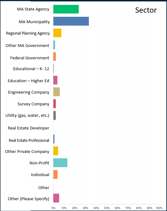
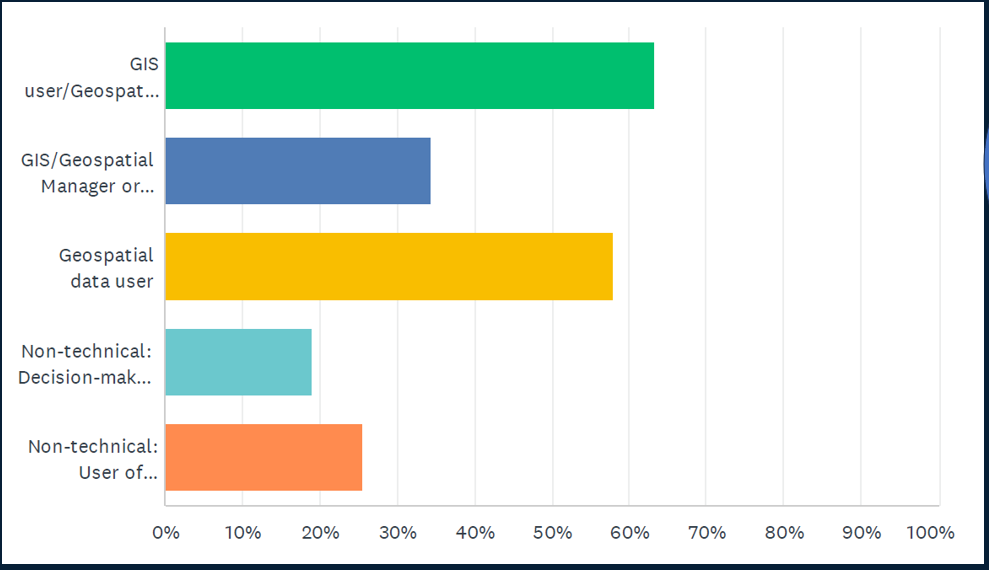
Stakeholder Participation
Highest participation rates came from state and local entities with a broad spectrum of interest areas represented across all participants. About 75% of respondents are geospatial-savvy
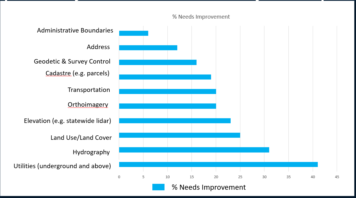
Data Theme Importance and Improvement
All data themes were important – above 90%. However, responses differed about needs for improvement
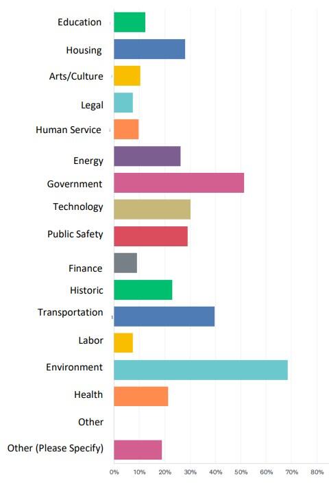
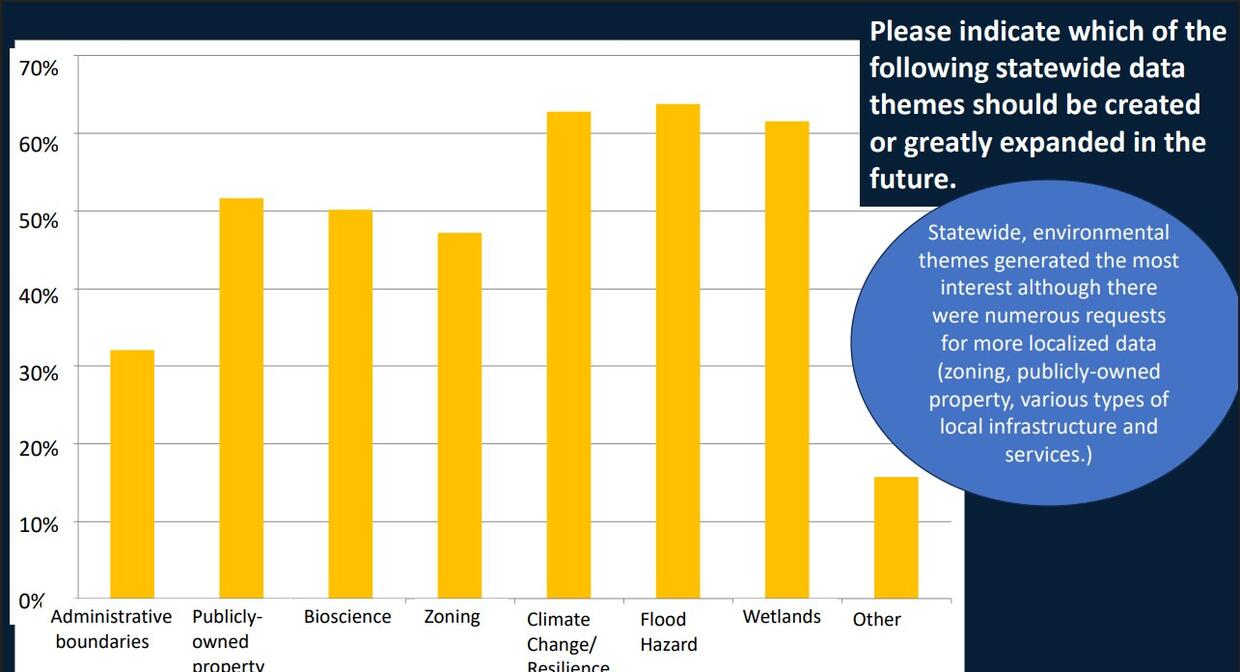
Expansion of Themes
"Please indicate which of the following statewide data themes should be created or greatly expanded in the future."
Statewide, environmental themes generated the most interest although there were numerous requests for more localized data (zoning, publicly-owned property, various types of local infrastructure and services.)
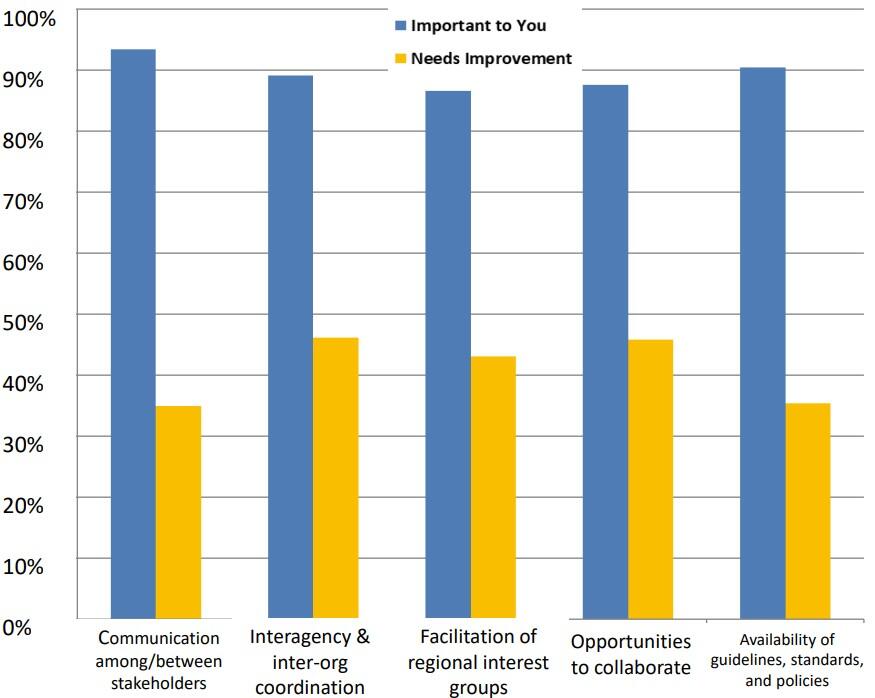
Activities Importance and Improvement
"Indicate whether the following coordination, communication, and governance activities are important to your work and whether they need improvement."
All participant groups found these activities to be important, but state agencies emphasized the improvement of guidelines, standards, and policies (51%).
Services Importance and Improvement
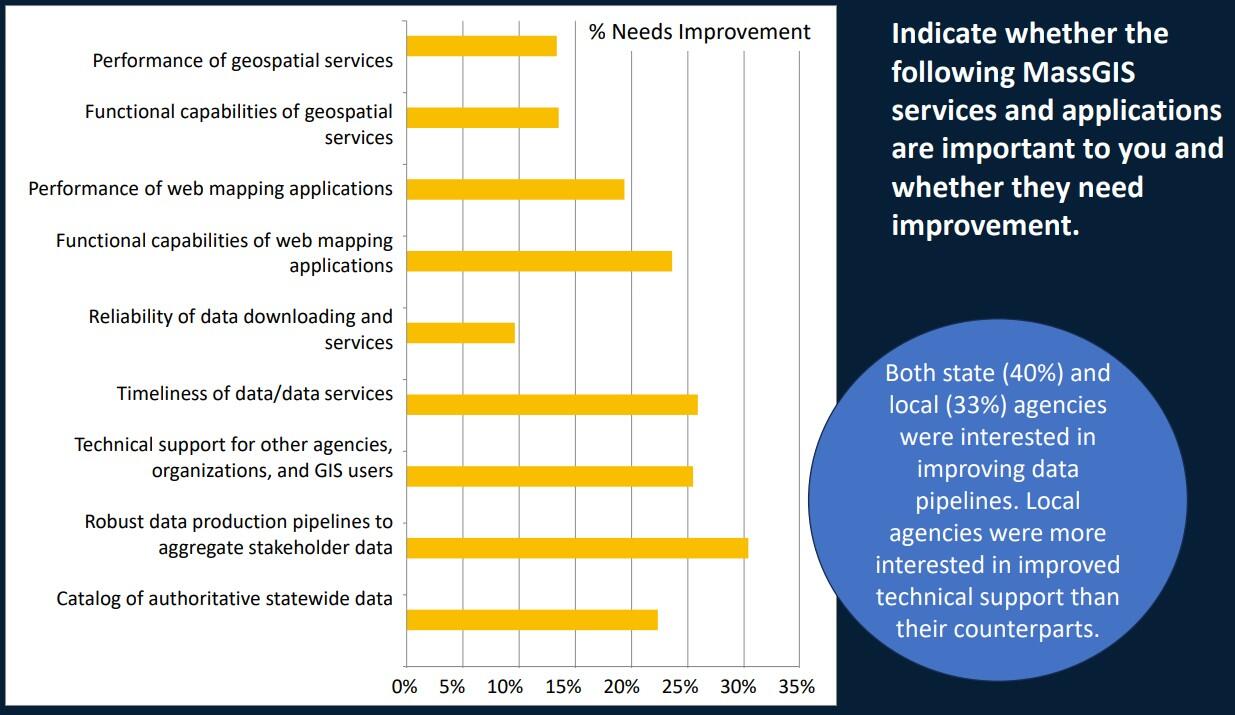
"Indicate whether the following MassGIS services and applications are important to you and whether they need improvement."
% Needs Improvement Both state (40%) and local (33%) agencies were interested in improving data pipelines. Local agencies were more interested in improved technical support than their counterparts.
How could/should geospatial maturity in Massachusetts be improved?
Collaboration
Foster partnerships with private sector, NGOs, all levels of government
Funding and Policy Development
Secure consistent funding that supports long-term data-sharing, creation, and publishing of timely, high-quality, authoritative data
Training and Education
Increase public awareness of geospatial data value; have training resources available to government agencies to increase use and quality of geospatial data
Data
Focus on data quality, accessibility, and usability. Prioritize open formats and standards. Improve data sharing and coordination across agencies
Technology
Bring the community "forward" in technology through licensing, and economies of scale. Plan for AI, machine learning, and the IoT streams of geospatial data
Remove Barriers
Strive to make the power of geospatial technology to all, so that there are no "haves' and "have-nots" in local governments and citizens
Activity #1 9:30am – 10:10am
Urgency and Importance
What outcomes should MaGICC council seek?
- Data Themes: Defined Core Data Content of the MA Spatial Data Infrastructure (Themes in the MSDI)
- Data Services: Defined Core Data Services (web maps, services) of the MSDI
- Data Stewardship: Established Data Stewardship Roles
- Technical Resources: Supply Additional Technical Resources to Local Governments
- Standards: Defined Statewide policies, standards and best practices around authoritative datasets
- State Funding: Established sustainable funding for GIS in state government
- Non-State Funding: Established sustainable funding for GIS in other (non-state) government
- Community Engagement: Enhanced and sustainable Massachusetts’ geospatial stakeholder community
- Legislation: Seek to have legislation concerning geospatial data
- Technology Integration: Integrated geospatial technologies and data throughout State and local government
- Data Quality: Seek to have mechanisms for ensuring SDI has high data quality
- Collaboration: Improved and expanded coordination and collaboration
Start The Activity (10 min)
On the small sticky notes write down the Council outcomes. One outcome per sticky note.
Brainstorm and Place Your Outcomes (25 min)
As a group discuss and place your sticky notes in one of the 4 quadrants to assign the outcomes an urgency and importance rating. Try to place only 3 outcomes per quadrant.
Submit Your Thoughts (5 min)
Bring your completed Urgency and Importance chart with the sticky notes to the facilitator. We will summarize the findings at the end of the day.
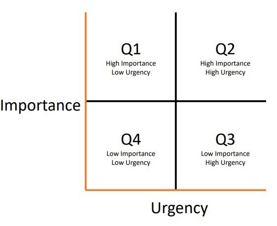
Importance and Urgency
- Q1: High Importance / Low Urgency
- Q2: High Importance / High Urgency
- Q3: Low Importance/ High Urgency
- Q4: Low Importance / Low Urgency
Activity #2 10:20am – 11:05am
Mechanisms for Engagement
How do we ensure MaGICC represents Stakeholder needs?
Start The Activity (15 Mins)
On the large white paper write down words, phrases or ideas for how the Council can ensure stakeholder representation.
Prioritize Your Ideas (10 Mins)
As a group, discuss, determine and select the 2 most actionable ideas. Circle them and prepare to present to the group.
Report Out (15 Mins)
Pick a spokesperson for your group. Describe and elaborate on what your group believes are the two most important ideas.
Examples of ideas that might come forward
- The Council sponsors coordination workshops open to all in several parts of the state during each year
- The Council has a formal reporting structure to the Legislature and Governor, and reports are publicized for all to see
- Legislation: the Council is created by legislation crafted with and sponsored by the GIS stakeholder community
- MassGIS promotes and supports geospatial stakeholder interest group meetings to inform and advise the Council
Activity #3 11:05am – 11:50am
Actions and Activities
Devise feasible, innovative proposals for actions or activities that benefit the geospatial community. For each proposal, state whether the time frame to be achieved is 1 year, 3 years, or 5 years.
Brainstorm Actions (15 min)
As a group, discuss and write down ideas of actions and activities that would benefit the Massachusetts geospatial community
Present Your Actions (20 min)
Pick a spokesperson for your group. Describe and elaborate on what your group believes is the single most important idea.
Vote! (10 min)
Use the honor system and individually vote for your top workshop idea. Don't raise your hand more than 1 time!“ Write on your group’s notepad how many votes it received.
Example Idea #1:
Start regional centers at partnering universities to offer affordable GIS support to local entities while giving students training and work experience.
Example Idea #2:
A state-administered geospatial capacity-building grant program.
Parting Thoughts?
Open discussion - thoughts?
What did we miss, what did you hear, what stood out?
Do you have any questions?
Thank You For Your Participation!
Cy Smith State GIO & Director, MassGIS
Peter Lemack Senior Project Manager, Sanborn
| Last updated: | February 20, 2026 |
|---|