Geography - Census Boundary Areas
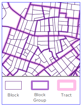
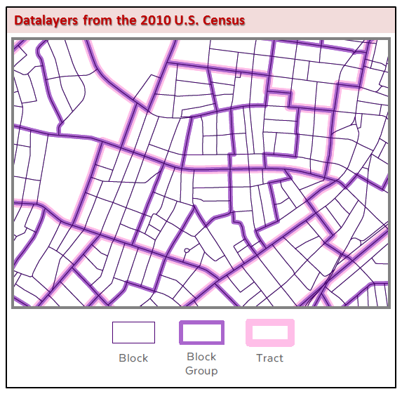
Census geographic areas, or units, are used by the Bureau to collect and tabulate decennial census data. Three levels are available from MassGIS (with layer name in parentheses) in the following hierarchy:
- Blocks (CENSUS2010BLOCKS_POLY) - bounded on all sides by visible features, such as streets, roads, streams, and railroad tracks, and by non-visible boundaries such as city, town, township, and county limits, and short line-of-sight extensions of streets and roads. Often the size of a city block in urban areas; their size varies in other parts of the state.
- Block Groups (CENSUS2010BLOCKGROUPS_POLY) - clusters of blocks within the same census tract that have the same first digit of their 4-digit census block number.
- Tracts (CENSUS2010TRACTS_POLY) - clusters of block groups which generally have a total population size between 1,200 and 8,000 people with an optimum size of 4,000 people.
Note that the "POP100_RE" fields store the 100% population count as listed in the PL-94-171 demographics tables (the 'RE' in the field name stands for 'redistricting'). The housing unit counts ("HU100_RE") were generated from the same PL-94-171 tables.
For more information on 2010 Census geography, see the US Census data website.
MassGIS added the following fields to the above three datasets to facilitate joining to the tables listed below:
| FIELD NAME | TYPE / WIDTH | DESCRIPTION |
|---|---|---|
| LOGPL94171 | C / 7 | Joins to the LOGRECNO in the PL-94-171 tables |
| LOGSF1 | N / 10 | Joins to the LOGRECNO in the SF1 tables (for use with SF1 tables distributed by MassGIS with LOGRECNO as a numeric field) This identifier field contains information that was originally a text value with leading zeroes like the other linking fields, but was converted to numeric by using instructions and database templates with formatting errors provided by the Census Bureau. By the time this error was realized, the attribute tables had already been processed and it was decided to retain the formatting error, as a correction would have been time-consuming and not affected the functionality of the data. Also included is the LOGSF1C field, calculated by MassGIS from LOGSF1, which contains these values as text with the leading zeros preserved. |
| LOGACS0610 | C / 10 | Joins to the LOGRECNO in the ACS 2006-2010 tables (Not included in the BLOCKS layer) |
| LOGSF1C | C / 10 | Joins to the LOGRECNO in the SF1 tables (for use with SF1 tables from other sources with LOGRECNO as a character field) |
Download the Census Blocks, Block Groups and Tracts (.zip files):
Shapefiles (82 MB) | ArcGIS 9.3 File Geodatabase (49 MB)
** NOTE: The geography was replaced on 4/17/2012
with fields added for joining to related tables **
Redistricting Data (Public Law 94-171) Summary File
The PL-94-171 data were created for the purposes of redistricting and contain limited population and housing data. MassGIS distributes four tables for each of the three levels of geography (twelve tables in all) that store the following PL94-171 demographic data:
- P1 - race from a count of total population
- P2 - Hispanic or Latino, and not Hispanic or Latino persons by race from a count of total population
- P3 - race from a count of the population 18 years and over
- P4_H1 - Hispanic or Latino, and not Hispanic or Latino persons by race from a count of the population 18 years and over. Table H1, aggregated to table P4 by MassGIS, contains data on occupancy status by housing unit.
To join these tables to the geographic layers (Blocks, Block Groups and Tracts), use the LOGPL94171 field in the geography and the LOGRECNO field in the PL-94-171 tables.
Download the PL-94-171 data (.zip files):
dBase tables (19 MB) | Access 2003 databases (11 MB)
Includes PDF documentation
Summary File 1 (SF1)
A more expansive and detailed set of demographic data than those included in the PL-94-171 data, the SF1 tables contain information on age, sex, households, families, relationship to householder, housing units, detailed race and Hispanic or Latino origin groups, and group quarters. MassGIS acquired and processed a subset of the Massachusetts data from SF1 into a more user-friendly format with more intuitive field names. For each level of geography are the following seven tables (21 tables in all):
- Group Quarters (CEN2010_geog-level_SF1_GROUP_QUARTERS)
- Households by Age, Family and Children (CEN2010_geog-level_SF1_HH_AGE_FAM_CH)
- Households Size by Family (CEN2010_geog-level_SF1_HH_SIZE_FAM)
- Housing Owner Rental Demographics (CEN2010_geog-level_SF1_HOU_OWN_REN_DEM)
- Housing Residency Characteristics (CEN2010_geog-level_SF1_HOU_RES_CHAR)
- Population by Age and Gender (CEN2010_geog-level_SF1_POP_AGE_GENDER)
- Population by Race (CEN2010_geog-level_SF1_POP_RACE)
In the list above, "geog_level" is a placeholder for the level of geography abbreviation used in the table names: "B" for Blocks, "BG" for Block Groups, and "CT" for Census Tracts.
To join these tables to the geographic layers (Blocks, Block Groups and Tracts), use the LOGSF1 field in the geography and the LOGRECNO field in the SF1 tables.
MassGIS also distributes the full, unprocessed set of SF1 data for Massachusetts released by the Census Bureau. The seven tables above were chosen for additional processing because they generally contain the most widely used demographic data and, with the exception of the group quarters table, are comparable to the data data released in the SF3 dataset from the 2000 Census.
Review SF1 documentation.
Download the SF1 data (.zip files):
MassGIS "user-friendly" subset: dBase tables (32 MB) | Access 2003 databases (26 MB)
Full data from Census Bureau: Access 2003 databases (176 MB)
Includes PDF documentation and MassGIS field descriptions Excel file
NOTE: The MassGIS subset .zips were re-posted for download on 8/22/2012 to replace the POP_AGE_GENDER tables for each level of geography with correct values in the fields “POP_TOTAL”, “POP_MALE”, and “POP_FEM”. Originally, these fields contained the counts for only those under the age of 20 instead of the true total population counts.
Explore more Census data at data.census.gov
Data.census.gov site is the new platform to access data and digital content from the U.S. Census Bureau, replacing other tools (e.g., American FactFinder).
American Community Survey (ACS) data may be downloaded from an Advanced Search. For example, narrow your search in the Browse Filters section:
- Topics (e.g. Income and Poverty)
- Geography (e.g. All Block Groups within Norfolk County, Mass…)
- Years (e.g. 2018)
- Surveys (e.g. ACS 5-Year Estimates Detailed Tables)
- Click SEARCH
- Choose a table (e.g. Median Household Income in the past 12 months (in 2018 Inflation-Adjusted Dollars). The table will display.
- Check the box next to that table's title in the left pane.
- Scroll to the top of the left pane and click Download Selected
- A 'Download / Print / Share' section will appear at the bottom. Click DOWNLOAD in the lower right of the screen to save the table in CSV format.
You will need to format the table in order to join it to the associated geography. To continue with the example above:
- Open the CSV in a spreadsheet editing program such as Excel.
- Remove the second row as it contains long text describing the fields.
- Save the file and exit.
- Add the CSV to your GIS software and save it to a compatible format (DBF, geodatabase table, etc.).
- Because the GEO_ID field contains extra characters, add a Text field (like 'GEOID_TXT'), length 12, and calculate it to the last 12 characters of GEO_ID. Ex., use this formula: Right( [GEO_ID], 12 )
- Join the table to your geography, where GEOID_TXT in the new table matches to GEOID10 in the spatial layer.
NOTE: 2005-2009 ACS demographic data will NOT link to the 2010 geography.
TIGER Roads and associated tables
- TIGER Roads (CENSUS2010TIGERROADS_ARC - an extract from the full TIGER/Line file; may be used for geocoding)
- TIGER Roads Address Range relationship file (CENSUS2010TIGERROADS_ADDR - constructed for geocoding)
- TIGER Roads feature names relationship table (CENSUS2010TIGERROADS_FN - both primary and alternate names)
- TIGER Roads feature names relationship table (CENSUS2010TIGERROADS_FNA - alternate names only)
TIGER linework lookup table for MTFCC codes and descriptions (CENSUS2010TIGERROADS_MTFCC - for legend symbology). See this document for details on these codes.
Download the TIGER Roads data (.zip files):
Shapefiles and .dbf files (96 MB) | 9.3 File Geodatabase (94 MB)
Other Geography
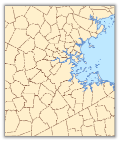
Municipalities (Cities and Towns)
MassGIS created the Municipal Boundaries from Census 2010 polygon feature class by dissolving the Census 2010 Block data on the COUSUBFP10 (county subdivision) field. Community-based attributes such as town name, ID and population were then added. This dataset may be used as basemap data when mapping Census 2010 geography, as other municipal boundary layers from MassGIS will not line up exactly with the Census geography. The polygon layer, CENSUS2010TOWNS_POLY, was converted to line features to produce the polyline layer CENSUS2010TOWNS_ARC, and the OUTLINE field was then added and coded.
The CENSUS2010TOWNS_POLY layer contains the following attributes:
| FIELD NAME | TYPE / WIDTH | DESCRIPTION |
|---|---|---|
| TOWN_ID | N / 4 | MassGIS Town ID |
| TOWN | C / 21 | Town Name (UPPERCASE) |
| TOWN2 | C / 21 | Town Name (Title Case) |
| COUSUBFP10 | C / 5 | County subdivision ID from the U.S. Census Bureau |
| FIPS_STCO | N / 4 | County code identifier |
| COUNTY | C / 15 | County Name |
| POP1980 | N / 6 | 1980 Population |
| POP1990 | N / 6 | 1990 Population |
| POP2000 | N / 6 | 2000 Population |
| POP2010 | N / 6 | 2010 Population |
| POPCH80_90 | N / 5 | Population Change, 1980-1990 |
| POPCH90_00 | N / 5 | Population Change, 1990-2000 |
| POPCH00_10 | N / 5 | Population Change, 2000-2010 |
| HU2010 | N / 5 | Housing Units, from 2010 Census |
| FOURCOLOR | N / 1 | Codes (1,2,3,4) allowing shading of all towns using 4 symbols (based on four-color theorem, where no adjacent polygons have same symbol) |
| TYPE | C / 2 | C = City, T = Town, TC = Town with City form of government (Source: City and Town Info at Secretary of State website). |
| AREA_ACRES | Double | Area of polygon(s) in acres |
| SQ_MI | Double | Area of polygon(s) in square miles |
The layer's arc attribute table contains an item added called OUTLINE, which enables differentiation of line type (e.g. dashed lines inside the state and solid for the outside). OUTLINE codes are:
1 = Interstate boundaries
17 = Internal boundaries
4 = Coastline
Download the Census 2010 Towns data (.zip files):
Shapefiles (5 MB) | 9.3 File Geodatabase (3 MB)
Water Features
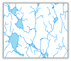
MassGIS created two water feature classes that may be used as basemap data when mapping Census 2010 geography, as other hydrography layers from MassGIS will not line up exactly with the Census geography. The polygon layer, CENSUS2010HYDRO_POLY, represents lakes and ponds. The features were selected from the Census Blocks (CENSUS2010BLOCKS_POLY) where ALAND10 = 0 and AWATER10 > 0. A few additional block polygons were added to this layer to maintain contiguity of water bodies, based on a visual check. Polygons were dissolved to remove any boundaries within a feature.
The polyline layer, CENSUS2010HYDRO_ARC, represents rivers and streams. The features were selected from 2010 TIGER linework where MTFCC is H1100, H3010 or H3020. Attributes include FULLNAME, the name of the river or stream (not all features are coded).
Download the Census 2010 Water Features data (16 MB)
(zipped shapefiles and ArcMap layer file)
Rail Features
The Rails data include all features where the MAF/TIGER Feature Classification Code (MTFCC) begins with "R". Included are above-ground main lines, spur lines, rail yards, and mass transit lines (streetcar track, subway trains). MassGIS extracted the linework for Massachusetts and projected it to the Mass. State Plane Meters NAD1983 coordinate system.
Attributes in the polyline feature class CENSUS2010RAIL_ARC include LINEARID (unique ID), FULLNAME (rail line name) and MTFCC (R1011 = Main, Spur, Yard; R1051 = Mass Transit). The feature class CENSUS2010RAIL_ARC_GEN is dissolved on FULLNAME and MTFCC
Download the Census 2010 Rail Lines data (880 kb)
(zipped shapefiles)
MassGIS Processing
Boundary Files
For the Blocks, Block Groups and Tracts, MassGIS projected the data acquired from the Census Bureau to the Massachusetts State Plane Mainland Meters coordinate system, and removed and/or clipped offshore polygons to match a reasonable expectation of the coastline, using the Municipalities as a guide for selected clipping. Some blank fields were removed and the LOGPL94171, LOGSF1, LOGACS0610, POP100_RE, HU100_RE, AREA_SQFT and AREA_ACRES fields were added and populated. Unlike in the 2000 Census data, a single LOGRENCO field is not included in the geographic layers' attribute tables because each set of related data (PL-94-171, SF1, and ACS) store different values in their LOGRECNO fields.
Summary File 1
On August 18th, 2011, the Census Bureau announced the availability of SF1 data for Massachusetts. Download the SF1 data for Massachusetts. These data were acquired by MassGIS, along with a template Microsoft Access database (SF1 Access 2007 Shell) to import the data into, instructions on how to correctly perform the import process, and the technical documentation required to understand the content and structure of the data. The raw SF1 data files were linked to the Access 2007 template and a series of scripts and queries were executed to generate two sets of tables: (A) one set with user-friendly, re-named fields that corresponds to a subset of the demographics and aliases that MassGIS provided for the 2000 Census (see the 2000 Census Block Groups example, and (B) another set representing the entirety of SF1 demographics available for Massachusetts at specific geography levels. The following is an inventory of the files produced by MassGIS:
- CEN2K10_SF1_MGIS_BLK.mdb – Access 2003 database containing tables with re-named attributes that correspond to some of the attributes provided by MassGIS for Summary File 3 (SF3) for Census 2000 blockgroups**. The demographics in this database link to the Census 2010 blocks.
- CEN2K10_SF1_MGIS_BLKGRP.mdb – Access 2003 database containing tables with re-named attributes that correspond to some of the attributes provided by MassGIS for Summary File 3 (SF3) for Census 2000 blockgroups**. The demographics in this database link to the Census 2010 blockgroups.
- CEN2K10_SF1_MGIS_TRACT.mdb – Access 2003 database containing tables with re-named attributes that correspond to some of the attributes provided by MassGIS for Summary File 3 (SF3) for Census 2000 blockgroups**. The demographics in this database link to the Census 2010 tracts.
**Not all of the data available from the Census 2000 version of SF3 is contained in the Census 2010 version of SF1. The tables that were reproducible by MassGIS are “pop_by_race”, “pop_by_age_gender”, “housing_residency_characteristics”, “housing_owner_rental_demographics”, “households_size_by_family”, and “households_by_age_family_children”. An additional table “group_quarters_pop” has also been produced from the Census 2010 version of SF1.
The same alias field name was used when the description of the demographic attribute in Census 2000 SF3 was identical to Census 2010 SF1 (with the possible exception of attributes dependent upon the definition of “married couples” vs. “husband-wife couples”. See each summary file’s technical documentation, the 2010 SF1 press_release for further clarification.) A lookup table of the MassGIS alias field names, original Census field names, and table names can be found in the spreadsheet SF1_2011_MGISfields.xlsIt is anticipated that the remaining tables from Census 2000 SF3 not represented by SF1 here can be re-created after the release of the 2006-2010 American Community Survey (ACS) 5-year estimates.
- SF1_Access2003_blks1.mdb and SF1_Access2003_blks2.mdb-- Access 2003 databases containing all of the tables and attributes provided by SF1, but limited to just the block summary level (101). The block-level data exceeds the 2GB file size limit of a standard Access database, and necessitated splitting it up into two databases. The first database (blks1) contains data segments Ma000012010 through Ma000092010 while the second database (blks2) contains data segments Ma000102010 through Ma000462010. The demographics in these databases link to the Census 2010 blocks. ***
- SF1_Access2003_blkgrps.mdb -- Access 2003 database containing all of the tables and attributes provided by SF1, but limited to just the blockgroup summary level (150). The demographics in this database link to the Census 2010 blockgroups.***
- SF1_Access2003_tracts.mdb -- Access 2003 database containing all of the tables and attributes provided by SF1, but limited to just the tract summary level (140). The demographics in this database link to the Census 2010 tracts.
***Some of the tables in these databases have been deleted where they were reserved for data aggregated and reported only down to the census tract level. Since blocks and blockgroups are lower geography levels than tracts (many blocks comprise a blockgroup; many blockgroups comprise a census tract), no information is available at those geography levels and the tables would have remained empty.
The tables in these databases are “segment tables”. (See page 2 and 3 of the SF1 README file for an explanation of table segmentation) A segment table contains the attributes of 1 or more of the demographics tables specified in SF1. Each segment table name consists of a prefix added by MassGIS that identifies the geography level used to create it (BLK, BLKGRP, or TRCT) followed by “_Ma” (indicating it is data for the state of Massachusetts), followed by “000” (placeholders), followed by two digits (i.e. “02” or “41”) that denote the data file segment number, followed by “2010” (indicating the Census vintage year). Segment table 45 is split into two parts in the Access database template provided by the Census Bureau. The table “DATA_FIELD_DESCRIPTIONS” is a comprehensive listing of all attributes in SF1 and duplicates the information found in Chapter 6 of the technical documentation. “Mageo2010” is a geographic header file, but should not be needed as MassGIS has already extracted the records associated with specific geographies.
To account for disparity in software versions among users and allow for greater accessibility to the data, the Access 2007 databases that MassGIS worked with during processing were converted to Access 2003 versions and are distributed as such. For users without a copy of MS Access, potential suitable alternatives to view, query, or otherwise further process the data include the Open Office Base product, or ESRI’s ArcGIS software.
The tables in each of the aforementioned databases all contain the field LOGRECNO which serves as the unique identifier for the purpose of linking to the various 2010 Census geographies provided by MassGIS. Furthermore, most of the tables also contain a GEOID10 field added by MassGIS that represents a unique geographic ID and is generated by a concatenation of constituent geography codes:
i.e. 250092213001002 = STATE CODE (“25” for MA) + COUNTY (“009” – Essex County) + CENSUS TRACT (“221300”) + CENSUS BLOCK (“1002”)
GEOID10 can also generally be used to link to the Census geography files instead of LOGRECNO, but the second set of databases containing all of the tables/attributes from SF1 do not have a GEOID10 field added to segment tables *_Ma000062010, *_Ma000112010, and *_Ma000382010 because they already contained the maximum number of fields allowable in an Access table.
TIGER
For the TIGER roads, county-based datasets from the "all lines" version distributed by the Census Bureau were merged into a statewide layer and projected to the Massachusetts State Plane Mainland Meters coordinate system. The merge process yielded 183 pairs of segments that shared the same unique ID (roads that exist along county borders). One duplicate was eliminated from each pair. Only road feature types were included in this processing. Some fields were deleted and the fields LTOWN, RTOWN, L_TOWNID, R_TOWNID, L_BLKID10, and R_BLKID10 were added and populated.
If any problems or issues are found, please e-mail Dan Marrier.
MassGIS also publishes newer Census data: