Downloads
Overview
After every national decennial census, voting districts are redelineated to accommodate changes in both population counts and the location of those populations to achieve equitable representation in government. This process is commonly referred to as “redistricting” when it affects districts at the federal level (Congressional districts) and the state level (State House and State Senate legislative districts, and the Governor’s Council districts), and as “reprecincting” when it affects districts at the local level (municipal wards and precincts). An additional distinction is that the districts at the federal and state levels are voted on and approved by the state legislature and Governor whereas wards and precincts are approved by the Local Election Districts Review Commission (LEDRC) in accordance with state law.
Redistricting and reprecincting make use of the updated Census geography and population counts produced for that purpose in the U.S. Census Redistricting File (Public Law 94-171) Dataset. However, operational challenges encountered during the COVID-19 pandemic delayed the release of the 2020 U.S. Census redistricting file by several months. In previous decennial efforts, cities and towns have used that data to update their local voting district boundaries as a precursor to those updated wards and precincts being used in the redistricting efforts at the state and federal levels. But in October 2021 legislation was passed that allowed State and Congressional voting districts to be updated before the local reprecincting updates were complete. State and Congressional voting districts were updated and legally approved in November of 2021, influenced by ward and precinct boundaries established after the 2010 Census, not the 2020 Census.
- Congressional Districts, Chapter 93 of the Acts of 2021
- Representative Districts, Chapter 83 of the Acts of 2021
- Senatorial Districts, Chapter 82 of the Acts of 2021
- Governor’s Council, Chapter 92 of the Acts of 2021
When the local wards and precincts were fully updated and approved by the revised December 15, 2021 deadline set by the October 2021 legislation, many of the redelineated precincts had partial areas assigned to different updated State and/or Congressional districts than other areas within the same precinct. Functionally, this means voters in each of these precincts have the same voting options and representatives in local government elections but are split up in State and/or Congressional elections. To ensure ballots with the correct voting options are generated for each voter in these precincts, subprecincts have been defined, named, and developed as a geographic data set by the Secretary of the Commonwealth’s Elections Division.
Subprecincts represent areas within individual precincts that have been assigned to a State and/or Congressional voting district that is different than those assigned to other areas within that same precinct. The determination of which portion of the precinct is classified as a subprecinct area is established through geographic identification of the 2020 Census blocks and tracts assigned to State and/or Congressional districts in the legislation. Subprecinct boundaries are coincident with the “parent” precinct boundary except where the split in State and/or Congressional representation occurs; in those locations the subprecinct boundary is coincident with the State and/or Congressional voting district boundary.
The layer is named SUBPRECINCTS2022_POLY.
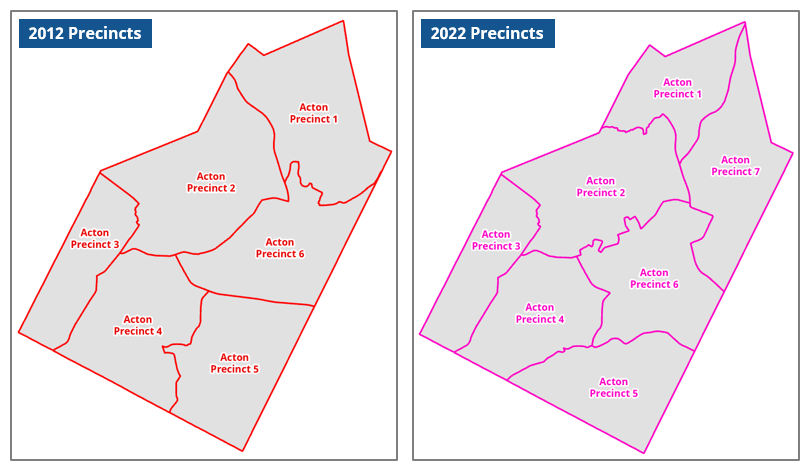
Example: Precincts in the town of Acton
The first set of maps (Figure 1) shows the six precincts approved in 2012 using 2010 Census data and the seven precincts approved in 2022 using 2020 Census data. An increase in population was responsible for the addition of a new precinct in 2022 and required redelineation of the previous precincts.
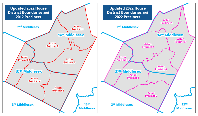
In the next two maps (Figure 2), both the older and newer Acton precincts are shown along with the updated 2022 Massachusetts House of Representatives District boundaries. The boundary between the 14th Middlesex and 37th Middlesex districts in Acton is perfectly coincident with the 2012 Acton precinct boundaries, but splits Acton Precinct 6 in the 2022 precincts. This indicates that the 2022 House district boundaries were updated prior to the Acton Precincts being updated and approved. After the Acton precincts were updated, some voters in Precinct 6 belonged to the 14th Middlesex district and others belonged to the 37th Middlesex district instead of all being assigned to a single House district.
The next map (Figure 3) shows that section of Acton Precinct 6 assigned to the 37th Middlesex District represented by the new subprecinct “6A”. It remains a part of Acton Precinct 6.
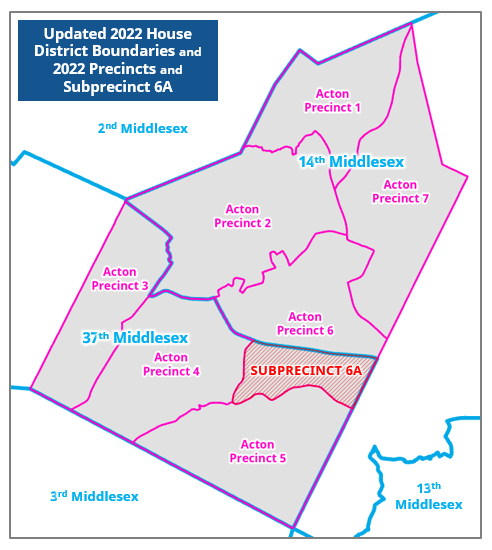
All voters in Acton Precinct 6 should have the same candidate options listed for local elections on their ballots. But the voters in subprecinct 6A will see Massachusetts House of Representative candidates for the 37th Middlesex District while the rest of Precinct 6 will see the 14th Middlesex District candidates on their ballots.
Production
Subprecinct geography is maintained separately from the wards and precincts geography, but the two must co-exist and be used together when voting district maps and election ballots are involved.
Chapter 82, Chapter 83, and Chapter 93 of the State Legislative Acts of 2021 defined district areas by referencing cities/towns and/or 2020 Census voting district (VTD) geographies and 2020 Census Block geographies. The 11-digit VTD values represent Census tracts, and Census blocks are represented by 15-digit ID values. More information about Census geography IDs
Using block reports that associated 2020 Census blocks with the updated districts, the Secretary of the Commonwealth’s Elections Division identified those blocks with attributes uncommon from the majority of the blocks in each district. After verification with GIS, those blocks were aggregated into subprecinct areas and assigned identifiers as defined in the Attributes section below.
MassGIS performed additional QA and provided some basic standardization of attribution to facilitate display and use of the data by GIS practitioners.
While the subprecincts in this data layer are the product of the Secretary of Commonwealth’s Elections Division for purposes of elections administration, a small number of subprecincts are established by law but do not exist in this data. These excluded subprecincts create unique polling places within each precinct where they exist and are functionally different than the subprecincts needed to ensure correct ballot options are available to voters when those options are different within a precinct. Some examples of these excluded subprecincts.
Attributes
The Subprecincts layer's polygon attribute table contains the following fields (with field name aliases in the MassGIS database):
| Field | Description |
|---|---|
| PARENT_PCT | (Parent Precinct) – The current precinct (updated after the 2020 Census) that the subprecinct exists inside of. These names match the WP_NAME (Ward and Precinct Name) values found in the 2022 Wards and Precincts data layer. |
| SUBPRECINCT | (Subprecinct) – The identifier assigned to the subprecinct. This subprecinct identifier is derived from the WP_DISTRICT (Ward and Precinct District) value of the parent precinct and appends an alphabetic character if the WP_DISTRICT value ends in a number or appends a number if the WP_DISTRICT value ends with an alphabetic character. Examples: - Parent precinct "Andover Precinct 4" has a subprecinct "4A". - Parent precinct "Braintree Precinct 3B" has a subprecinct "3B1". - Parent precinct "Framingham Precinct 21" has three subprecincts, "21A", "21B", and "21C". |
| CNGRS_DIST | (Congressional District) – If this field is populated, it represents the Congressional district assigned to the voters in the subprecinct that is different than the Congressional district(s) assigned to the voters in the remainder of the parent precinct. |
| HOUSE_DIST | (House District) – If this field is populated, it represents the Massachusetts House of Representatives district assigned to the voters in the subprecinct that is different than the Massachusetts House of Representatives district(s) assigned to the voters in the remainder of the parent precinct. |
| SENAT_DIST | (Senate District) – If this field is populated, it represents the Massachusetts Senate district assigned to the voters in the subprecinct that is different than the Massachusetts Senate district(s) assigned to the voters in the remainder of the parent precinct. |
| TOWN | (Town) – The name of the city or town that the subprecinct exists within. |
| TOWN_ID | (Town ID) – The MassGIS city/town ID (1-351) assigned to the TOWN. |
** Every subprecinct will have a value in one or more of the CNGRS_DIST, HOUSE_DIST, and SENAT_DIST fields that provide the justification for the subprecinct’s creation.
Maintenance
The subprecinct data is maintained by the Secretary of the Commonwealth’s Office. Any approved updates will be sent to MassGIS and made available as needed, and the metadata will be updated to reflect them.
The current subprecincts should be rendered obsolete after the 2030 U.S. Census and its subsequent redistricting effort.
Any additional questions about subprecincts should be directed to ma2020census@sec.state.ma.us.
Update
- September 27, 2023 – Groton subprecinct 3A was eliminated by legislation.
| Date published: | October 31, 2023 |
|---|