Downloads
Download .zip (20 MB) includes a shapefile and ArcGIS 10.0 layer file.
Overview

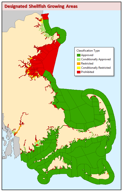
The Designated Shellfish Growing Area (DSGA) datalayer was compiled by the Department of Fish and Game's (DFG) Division of Marine Fisheries (DMF). DMF's Shellfish Project designated 295 growing areas in Massachusetts.
A designated shellfish growing area is an area of potential shellfish habitat, and all DSGAs make up the territorial waters (intertidal zone to the state line) of the Commonwealth. Growing areas are managed with respect to shellfish harvest for direct human consumption, and comprise at least one or more classification areas. The classification areas (783 total) are the management units, and range from being approved to prohibited (five classification types in all) with respect to shellfish harvest. For example, one growing area may be composed of four classification areas, all of which are managed separately (have a classification type the same or different from the rest of the growing area). This layer reflects classification areas as of February 10, 2025.
The DSGA data are stored in a polygon feature class named DSGA_POLY.
Production
The growing areas and their classification areas were defined by DMF shellfish project biologists. Compilation base maps covering the entire coast and islands were plotted at 1:5,000 using 1:5,000 Color Ortho Imagery and 1:24,000 USGS Topographic maps, all modified and enhanced by MassGIS. In addition, town boundaries, the territorial waters line and roads were plotted on these base maps. Shellfish project biologists compiled area boundaries onto the base maps, and these boundaries were then digitized or constructed using existing hydrography, town or territorial sea lines by DMF GIS personnel. Check plots were created and boundaries QA/QC'd by the biologists.
Separate 11 x 17 color plots are produced for each growing area based on the map extent of the area and its sampling stations. Classification area lines which need to be added, moved or deleted are compiled on these plots and automated by DMF GIS staff. A new 11 x 17 is produced and kept on file until another area change occurs.
Attributes
The polygon attribute table has the following attributes associated with each polygon:
| Field name | Description |
|---|---|
| NAME | Classification area name. Format starts with the Growing area and is appended by a ‘.’ and a unique number within the growing area. For example: Growing area N2 contains a classification area N2.1. |
| CONTACT | Name of shellfish biologist responsible for the area |
| ACRES | Acreage of classification area |
| BEGIN_DATE | Date when the last change in the classification area occurred, either a classification change or a line/boundary redefinition. |
| GROWING_AR | Code name for growing area. For example: N2 is the GROWING_AR for the Merrimack River |
| AREA_DESC | Well-known local name for each classification area. |
| CLASS | Sanitary classification of shellfish growing area in accordance with the National Shellfish Sanitation Program. The five classification types are listed below. |
| CONDITION | Denotes what type of condition applies for conditional area management. There are three types possible: rainfall, season, or both. |
Classification Types:
MarineFisheries’ sanitary classifications of shellfish growing areas are in accordance with the National Shellfish Sanitation Program. They do not indicate the current status, either “open” or “closed” to harvesting, due to shellfish management or public health reasons. Always confirm the status with local authorities and/or MarineFisheries.
| Field name | Description |
|---|---|
| APPROVED | Harvest of shellstock for direct human consumption allowed. |
| CONDITIONALLY APPROVED | Meets the criteria for the approved classification except under certain conditions described in a management plan. |
| RESTRICTED | Harvest allowed by special license and the shellstock, following harvest, is subjected to a suitable and effective treatment process through relaying or depuration. |
| CONDITIONALLY RESTRICTED | Meets the criteria for the restricted classification except under certain conditions described in a management plan. |
| PROHIBITED | Harvest of shellstock for any purpose is not permitted. |
Historical information about each area is maintained, beginning January 1, 1995. In addition, area information is also associated with water quality and marine biotoxin sampling data collected by shellfish project biologists, used to manage the areas. A separate GIS datalayer called Shellfish Sampling Stations has been created to maintain the sampling points.
Maintenance
The Division of Marine Fisheries maintains this datalayer. With the October 2009 update the lines feature class DSGA_ARC was dropped. Also see Shellfish Suitability Areas datalayer description.