Downloads
Overview
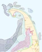
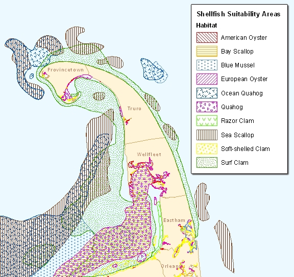
The ten species are:
- American Oyster
- Bay Scallop
- Blue Mussel
- European Oyster
- Ocean Quahog
- Quahog
- Razor Clam
- Sea Scallop
- Soft-shelled Clam
- Surf Clam
The polygons delineate areas that are believed to be suitable for shellfish based on the expertise of the Massachusetts Division of Marine Fisheries (Marine Fisheries) and local Shellfish Constables, input from commercial fishermen, and information contained in maps and studies of shellfish in Massachusetts. The areas covered include sites where shellfish have been observed since the mid-1970’s, but may not currently support any shellfish. Therefore, these maps represent potential habitat areas. Site specific surveys may be necessary to ascertain current distribution and abundance but will not be used to alter the designation of potential habitat without Marine Fisheries input. Additionally, because of the changing habitat and water quality conditions, lands containing shellfish likely exist in areas not identified on these maps. As such, these layers should not be used as a primary source to make site specific assessments for impact or mitigation.
The layer is stored in ArcSDE as SHELLFISHSUIT_POLY.
Production
This layer was developed by Marine Fisheries in collaboration with the Massachusetts Office of Coastal Zone Management (CZM) and the National Oceanographic and Atmospheric Administration (NOAA) Coastal Services Center (CSC).
Areas determined to be suitable for the ten species of shellfish were hand drawn on overlays using either the DMF Designated Shellfish Growing Areas or NOAA Nautical Charts as base maps. The CSC digitized the maps by scanning the overlays and vectorizing the scanned lines. The maps were then checked for accuracy and any missing or incorrectly vectorized lines were corrected. The polygon lines were then snapped directly to the MassGIS Coastline (1:25,000) of 1992 and edited for consistency with the polygon on the base maps.
The layer was then turned into an ArcInfo coverage and was cleaned and built to create polygons. The base maps were then used to code each of the polygons in the layer. When all of the sheets were completed they were checked for errors and quality assurance. The maps were separated into individual layers for each species and saved as shapefiles.
MassGIS combined the ten separate shapefiles into one ArcSDE layer, with each polygon coded for the species potentially present in that area. Because some species habitats overlap, overlapping polygons exist within the merged layer.
Attributes
The polygon attribute table contains the HABITAT (species potentially present in the polygon) and COM_NAME (common name of the shellfish species) fields, coded as follows:
| HABITAT | COM_NAME |
|---|---|
| AO | American Oyster |
| BS | Bay Scallop |
| BM | Blue Mussel |
| EO | European Oyster |
| OQ | Ocean Quahog |
| Q | Quahog |
| RC | Razor Clam |
| SS | Sea Scallop |
| SSC | Soft-shelled Clam |
| SC | Surf Clam |
Other attributes include:
| Field name | Description |
|---|---|
| LH_STAGE | The basic life history stage information such as spawning / settlement of shellfish species or migratory patterns of a finfish species. This information is being developed along with ongoing efforts to develop a spatial representation of the presence of select finfish and other important marine species in areas of the Commonwealth during one or more life history stage. |
| BEGIN_DATE | The beginning month and day of a life history stage. |
| END_DATE | The end month and day of a life history stage. BEGIN_DATE and END_DATE data do not reflect our time of year recommendations for individual projects or other management decisions. Those are made on a site specific/project specific basis. |
| ENTRY_DATE | The month, day, and year a modification or addition to the data is made. |
The units of the SHAPE.AREA and SHAPE.LENGTH fields are square meters and meters, respectively.
Maintenance
The November 2008 updates included recoding misidentified habitat data, modifying polygon shapes, and adding additional polygons based on new information. The field ENTRY_DATE was added to track changes over time to the data.
In May 2011, updates included the addition of newly identified habitat areas and modifications to the BEGIN_DATE and END_DATE fields to reflect important new life history stage information for select shellfish species. The new information in these fields is now consistent for shellfish species with information included in a new DMF technical report soon to be released by Marine Fisheries (TR-47: Marine Fisheries Time of Year Restrictions (TOYs) for Coastal Alteration Projects).
Updates will be provided to MassGIS by DMF when new information is available.
For questions regarding the programmatic content of this data contact Mike Hickey in the DMF New Bedford Office at (508) 990-2860 x122.