Downloads
.zip files includes ESRI Shapefile and ArcMap 10 layer file.
Overview

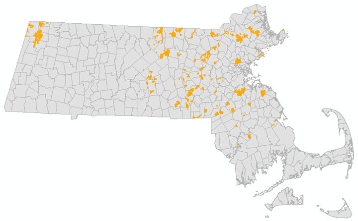
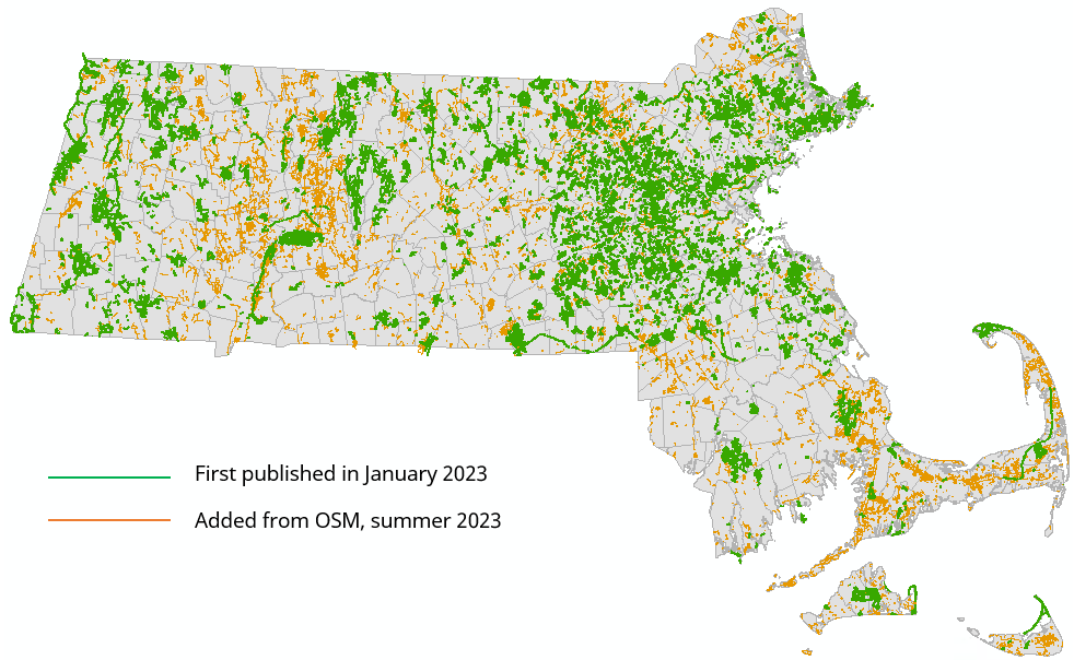
Although MassGIS has served trails information from the Department of Conservation and Recreation (DCR) for many years, this new Trails layer is MassGIS’ first attempt at a statewide, multi-sourced dataset. This layer was initially created from two primary sources, DCR Trails and the Metropolitan Area Planning Council’s (MAPC) Trailmap, with a small amount of trails data added from OpenStreetMap (OSM), municipalities, and conservation organizations. A summer 2023 update added several thousand lines sourced from OSM.
This trails dataset was created for use in Response Assist, the State 911 Department’s mapping application, and is intended to assist telecommunicators with lost hikers and potentially respond to emergencies in remote areas. Because of these primary uses, we focused on those trails found in wilderness areas and used for hiking. We therefore omitted many arcs from the source data, including cart paths on golf courses, networks of paved paths on school campuses, sidewalks, and many other arcs that could functionally serve as trails but were in relatively open and developed areas.
MassGIS will maintain the Trails data as part of our 911 project and refresh it weekly. The number of updates will vary depending on the frequency of inputs from 911 staff and public sources.
There are many missing trails from this layer and it is hoped that it becomes more complete over time. If you would like to submit trails for inclusion in this dataset, please email MassGIS at Notify911Address@mass.gov.
MassGIS stores the data as MAD.TRAILS. File geodatabase and shapefile feature classes are named MAD_TRAILS, based on the spatial view MAD.TRAILS_SV_PUBLIC.
Attributes
The MAD.TRAILS layer contains the following fields:
| Field Name | Definition | Description |
|---|---|---|
| OBJECTID | NOT NULL NUMBER(38) | ESRI’s proprietary row identifier |
| GPS_DATE | NUMBER(38) | Last date arc was collected using GPS |
| ALT_NAME | NVARCHAR2(30) | Alternate trail name. Used when capturing more than one name |
| EDITOR_INI | NVARCHAR2(3) | Initials of last MassGIS team member to edit arc |
| SCR_TR_ID | NVARCHAR2(50) | Source Trail ID. Unique ID from the source layer where available |
| DATE_ADDED | NUMBER(38) | Date arc added to the MassGIS Trails layer |
| DATE_EDITD | NUMBER(38) | Last Edit Date to arc within the MassGIS Trails Layer |
| SRC_DATE | NUMBER(38) | Source date. Date of collection from source data, where available |
| SRC_DATA | NVARCHAR2(50) | Name of data source |
| TRAIL_NAME | NVARCHAR2(50) | Trail name |
| COLOR | NVARCHAR2(24) | Color of trail blaze. Included to capture the many color-coded blazes along paths. Could be used for symbology |
| COLOR2 | NVARCHAR2(24) | Color of trail blaze when there are two colors for an arc |
| COLOR3 | NVARCHAR2(24) | Color of trail blaze when there are three colors for an arc |
| COLOR4 | NVARCHAR2(24) | Color of trail blaze when there are four colors for an arc |
| COLOR5 | NVARCHAR2(24) | Color of trail blaze when there are five colors for an arc |
| TRAIL_SYMBOL | NVARCHAR2(24) | Trail symbol. Intended to capture symbols that signify particular trails like diamond trail, or circle trail. Could be used for symbology in conjunction with COLOR |
| FOR_VWP | NVARCHAR2(1) | Flag field used by MassGIS to assist in the creation of products. This field is used to identify those trails that cannot be shared with the public, such as those that pass private property or are unauthorized by the property owner. All lines distributed publicly are coded "Y". Field not included in download. |
| FOR_911 | NVARCHAR2(1) | Flag field used by MassGIS to assist in the creation of products for State 911. Field not included in download. |
| TOWN | NVARCHAR2(21) | City/town within which a trail arc exists |
| TOWN_ID | NUMBER(5) | City/town ID for the municipality within which a trail arc exists. IDs are a numeric value based on the alphabetical sequence of city/town names. |
| SITE_NAME | NVARCHAR2(120) | Name of the site a trail arc is within such as Middlesex Fells, Blue Hills, or State Forest. Based on Open Space GIS data |
| SHAPE | SDE.ST_GEOMETRY | Geometry field |
Methodology
There were four phases in creating the Trails layer: data preparation, trail editing within ArcGIS Online (AGOL), data review within ArcMap, and quality control.
Data Preparation
MassGIS is responsible for providing the spatial information used in Response Assist, the mapping application used in the Next Generation 911 system here in the Commonwealth. Some of the information provided, such as streets and address points, are at the core of the spatial functions used, including getting calls to the most appropriate 911 call center and dispatching emergency responders. In addition to these core data, layers are provided that serve more of a supporting role. These include features such as hydrology, schools, police and fire stations, hydrants, trails, and many other potentially useful layers. Trails in particular can be very useful in assisting lost hikers, either in helping them to find their way out of a wilderness area or helping responders reach them. MassGIS has provided some trails information for use in the 911 maps for many years but, the coverage was poor.
In the summer of 2022, MassGIS had an opportunity to work with an intern and decided to expand the trails data. In preparation for this work, an aggregate layer was created using information from DCR, MAPC, and the current layer being served to 911. More data was available, but with limited time, we had to limit the sources.
MAPC data was chosen because it provided information from a variety of sources, and although the data was focused primarily within the Boston metropolitan region, it was an excellent aggregated source. Additionally, much of the work we needed to do was already completed for this area.
In preparing the data for editing, staff identified and removed overlapping arcs as well as those arcs that represented roads. The general method of identification was to create start-, mid-, and endpoints for trails, and then find out how near those points were to either other trails or streets. Then, editors removed those arcs where all three where within a threshold distance of 5 meters. While not removing all duplicates, this method did a fair job of reducing the time required by the intern to delete the remaining.
Intern Editing within ArcGIS Online
Once prepared, the aggregate trails layer was published in ArcGIS Online (AGOL) and displayed in an application with a set of widgets that allowed the intern to work more efficiently. We asked the intern to:
- Remove the remaining duplicate trail arcs. This was sometimes complicated because two arcs could be close to each other and not be duplicates; rather, they could both represent real trails. In most of these situations, one of the arcs was removed.
- Remove trail arcs where they are coincident with MassGIS’ streets dataset.
- Either edit trail geometry or delete trail arcs where they passed through structures.
- Remove orphaned trail arcs. There were many cases where a single arc existed that did not either provide connectivity within a trails network, or did not provide egress to a feature.
- Remove trails that did not meet the definition we had set for trails, generally for hiking and within wilderness areas. Many such trails from the MAPC source were removed.
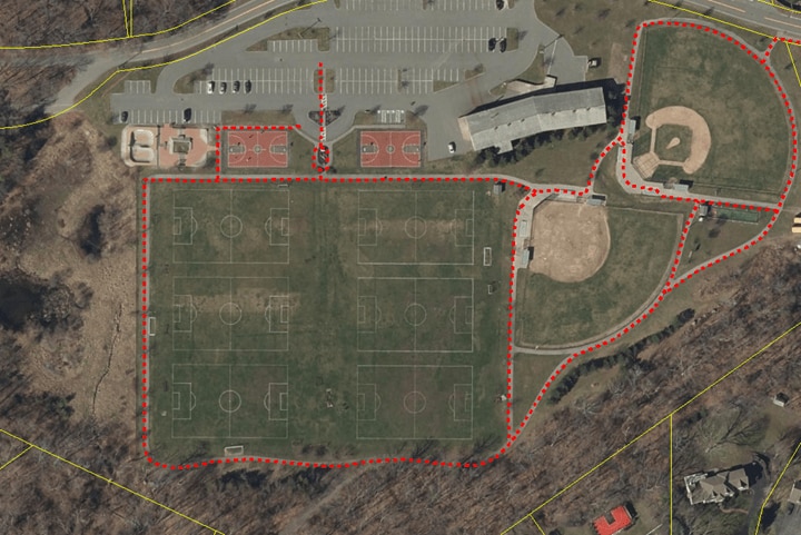
Example 1 below shows the kinds of trails that were removed from the aggregate product so they would not be included in the final Trails layer.
The intern completed two other editing tasks, but because of the small number of edits resulting from this effort, they are listed separately:
- copying arcs from Open Street Map (OSM) data into the aggregate layer. Generally, these arcs were added in cases where OSM trails provided connectivity between trail networks.
- improving trail geometry using 2021 lidar data as a guide. Trails are often clearly visible on the high quality lidar.
Data Review
At the end of seven weeks, the internship was over and MassGIS staff reviewed the data. Steps included:
- Planarizing all lines (splitting at intersections)
- Exploding all multipart features
- Splitting arcs at municipal boundaries
- Ensuring that all of the trails represented in the old trails dataset delivered to 911 were in the new layer
During this phase it became evident that the trails product that should be delivered to 911 was different than the product intended for the public. For example, there were many trails in the source data that existed within private property, meaning land owned by an individual per the Property Tax Parcels data as opposed to an entity associated with open space such as municipal conservation groups or Audubon. These private trails were flagged during review and are excluded from the new trails layer made available to the public. Also, there were trails on state land that DCR considers illegal trails, and because of their unknown condition, were also excluded in the publicly available product.
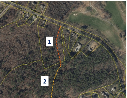
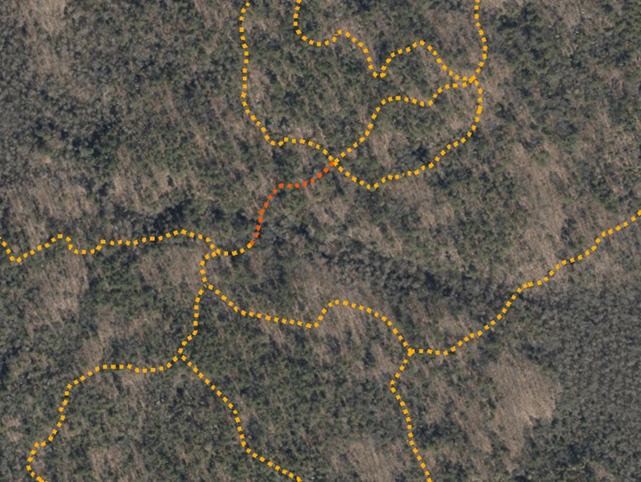
Two staff worked for approximately two months on the review, flagging private trails and continuing with the steps that were missed during the initial editing phase. Example 2 below shows trails symbolized as a dashed light orange line, while those trails flagged for exclusion from the publicly available product are shown in darker orange. Parcel boundaries are also shown (in yellow) along with the 2021 imagery.
Example 3 shows a portion of the trails network within Wompatuck State Park.
Quality Control
Once the review process was done, MassGIS staff completed these steps to ensure that data were consistent and fields were populated as expected:
- Checked domains for EDITOR_INI, SRC_DATA, COLOR fields
- Ensured date fields contained expected dates and in the expected format
- Found and replaced null values
- Looked for and replaced multi-part geometry with single-part
Summer 2023 Update
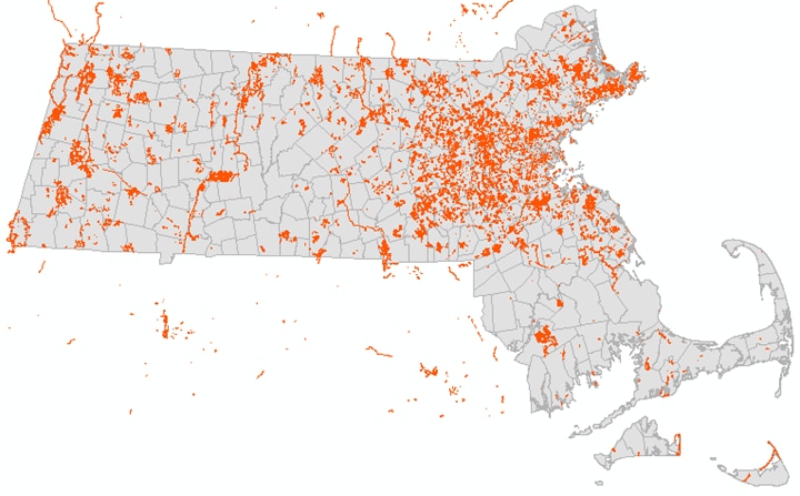
In the summer of 2023, the Executive Office of Technology Services and Security provided funding for MassGIS to hire an intern to add to the 911 Trails layer. This update focused on adding information from OpenStreetMap (OSM), mainly because their coverage appeared to be excellent. Our goal was to prioritize areas where our existing dataset was thinnest mainly, the southeast and Cape, the area in and around the Pioneer Valley, and Essex County. Fortunately for MassGIS our intern was incredibly efficient and was able to finish nearly all the statewide dataset, reviewing over 200,000 arcs. The small number of trails left to be integrated, as well as QC, was finished by MassGIS Staff. The result is a trails layer nearly doubled in size.
OSM trails were downloaded from the OSM Geofabrik Download Server site and reviewed. Because their trails included sidewalks plus other information that does not meet the specification for the 911 hiking trails, a subset was extracted. The query used to define the set used was ‘"fclass" IN( 'bridleway' , 'cycleway' , 'footway' , 'path' , 'track' , 'track_grade1' , 'track_grade2' , 'track_grade3' , 'track_grade4' , 'track_grade5' , 'unclassified' )’. This start set was then compared to our exiting trails and arcs coincident with existing arcs or streets were removed. OSM trails were also split at town lines and intersection with current data.
The first vintage of this trails data (from January 2023) and the OSM start set were published into an ArcGIS Online map that was then used to create an application where our intern could edit. The process used for editing and integration was very similar to methodology described in the Intern Editing within AGOL section above.
References
Trails resource links:
Maintenance
MassGIS will maintain the data as part of the 911 project and refresh it periodically. The number of updates will vary depending on the frequency of inputs from 911 staff and public sources.
There is tremendous opportunity to improve this data layer. Categories of potential improvement include:
- Missing information
- Improving the geographic accuracy
- Populating missing attribute information
If you have trails information that you would like to see included in 911 Trails please send them to Notify911Address@mass.gov for review.
Also see: