Downloads
Overview
The Impervious Surface raster layer represents impervious surfaces covering the Commonwealth of Massachusetts. The surfaces were extracted using semi-automated techniques by Sanborn Map Company from 50-cm Vexcel UltraCam near infrared orthoimagery that was acquired in April 2005 as part of the Aerial Imagery project. The pixel size for the impervious surface data is 1-meter.
Impervious surfaces are defined as:
- All constructed surfaces such as buildings, roads, parking lots, brick, asphalt, concrete.
- Also included are areas of man-made compacted soil or material such as mining or unpaved parking lots (no vegetation present)
Non-impervious surfaces can be defined as:
- All vegetated areas, natural and man-made
- Water bodies and wetland area
- Ski runs
- Natural occurring barren areas (i.e. rocky shores, sand, bare soil)
Each category is listed in detail in Table 1 below.
The dataset that MassGIS distributes also contains impervious surface pixels added by MassGIS that were created by buffering the MassDOT Roads layer. This process was done in order to fill in some breaks in roadway areas in the final Sanborn product delivered to MassGIS. This process is described in further detail below.
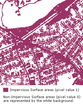
Impervious surface pixels are identified with a value of 1. Non-impervious surface pixels have a value of 0.
The statewide raster layer is named IMG_IMPERVIOUSSURFACE.
Production
A standard semi-automated methodology for extraction of impervious surfaces was developed and adopted. A hybrid classification method was used to extract impervious/pervious features. The primary software tools used were Definiens eCognition and Leica ERDAS Imagine. MassGIS then added a rasterized EOT Roads dataset. The overall process is described and shown below.
Impervious Surface Extraction Process
The process began with manually examining the images to determine the nature and distribution of classes. The particular approach to segmentation was adopted depending on the relative proportions of urban and vegetation features, as well as on the color-balancing (radiometry) of the images.
Automated Imagery Segmentation
1,554 ortho tiles were then segmented using eCognition software. Segmentation creates image objects by homogenizing ortho pixels based on shape, spectra, and texture criteria.
Rule-Based Classification of Segments to 18 Classes [See Table 1]
Each segmented ortho tile was classified using a rule-based classification method. A series of rules (mathematical expressions) was used to assign each “object” a final class designation of impervious or pervious surface.
Manual Quality Control and Editing
Each classified tile was manually reviewed and edited (if necessary) by QC / editing technicians.
Editing involved automated smoothing and removal of “unit pixel classes”, and aggregation to 6 P-Index Classes [see Table 1] and ultimately 2 Pervious/Impervious Classes.
Final Processing
Each impervious/pervious tile was:
- formatted to ERDAS Imagine (.img) file
- resampled to 1-meter pixel resolution
- attributed (color, class name/number)
TABLE 1: IMPERVIOUS/NON-IMPERVIOUS CLASSIFICATION MATRIX
Built-up
| Segment/Class | Shape | Perviousness | P-Index | P-Classification | Final P/I Class |
|---|---|---|---|---|---|
| Major Roads – Asphalted | Linear | Very Very Low | <10% | Very Low Pervious | IMPERVIOUS |
| Minor Roads – Asphalted | Linear | Very Low | <10% | Very Low Pervious | IMPERVIOUS |
| Small tracks/footpath – Soil/Grass | Linear | Low to Moderate | 10-30 to 30-60% | Low to Moderate Pervious | IMPERVIOUS |
| Houses/Buildings Rooftops | Geometric | Very Very Low | <10% | Very Low Pervious | IMPERVIOUS |
| Parking Lot – Asphalted | Large Geometric | Very Very Low | <10% | Very Low Pervious | IMPERVIOUS |
| Any other asphalted/cemented area | Geometric | Very Very Low | <10% | Very Low Pervious | IMPERVIOUS |
| Airstrips - Asphalted | Linear, Criss-cross | Low/td> | 10-30% | Low Pervious | IMPERVIOUS |
| Bridges - Asphalted | Linear over water | Very Low | <10% | Very Low Pervious | IMPERVIOUS |
| Stadiums - Roofs | Circular, Oval | Low to Moderate | 10-30 to 30-60% | Low to Moderate Pervious | IMPERVIOUS |
| Playgrounds – Soil/Grass | Geometric | Moderate to High | 30-60 to 60-90% | Moderate to High Pervious | NON-IMPERVIOUS |
| Open Areas | No particular shape | Very Very High | >90% | Very High Pervious | NON-IMPERVIOUS |
Vegetation (Non-Impervious)
| Segment/Class | Shape | Perviousness | P-Index | P-Classification |
|---|---|---|---|---|
| Farms/Fields | Geometric | Very Very High | >90% | Very High Pervious |
| Parks | Geometric | Very Very High | >90% | Very High Pervious |
| Green Areas | No particular shape | Very Very High | >90% | Very High Pervious |
| Tree-lined Areas | Linear-broad | High to Moderate | 60-90% to 30-60% | High Pervious to Moderate Pervious |
| Scanty Vegetation | No particular shape | High to Very High | 60-90% to >90% | High Pervious to Very High Pervious |
Waterbodies (Non-Impervious)
| Segment/Class | Shape | Perviousness | P-Index |
|---|---|---|---|
| Lakes | No particular shape | Very Very High | >90% |
| Rivers | Linear-broad | Very Very High | >90% |
| Ponds | No particular shape | Very Very High | >90% |
| Sea | - | Very Very High | >90% |
Addition of EOT Roads
The Sanborn Impervious Surface data, as delivered, occasionally showed breaks in the continuity of roads due to obscuration of the pavement by overhanging (mainly coniferous) trees [see Figure 1]. Also, some very narrow paved roads were sometimes omitted.
Therefore, MassGIS decided to combine the Sanborn data with data derived from the EOT road centerline (November, 2006). Much of the road linework was derived from 1:5000 Black and White Digital Orthophoto images, with other linework added by EOT atop the 2001/2003 Color Ortho Imagery.
The roads were buffered as follows:
- Where Width of Pavement was given, centerline was buffered this distance on both sides.
- Where Width of Pavement not specified, centerline buffered (Right of Way – 2 meters)
- Where Width of Pavement and ROW not specified, centerline buffered 3.5 meters.
The buffered road centerline was rasterized to a 1-meter GRID. The buffer distances were chosen conservatively, so that the gridded EOT-based road was usually narrower than the corresponding gridded Impervious Surface. [See Figure 2]
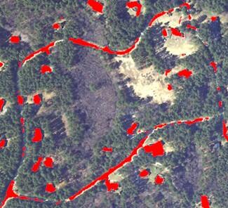
Figure 1: Impervious surface as delivered
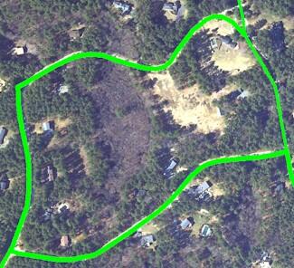
Figure 2: Rasterized buffered EOT Roads
Due to orthorectification differences between the two orthophoto datasets, the road centerline did not always overlay the exact center of the Impervious Surface road, and this resulted in occasional bulging or splitting of the gridded depiction of the road surface.
The original impervious data was combined with the buffered roads raster dataset (comparison shown in Figure 3) to produce a 1-bit (binary) raster dataset where all original Impervious data and the rasterized EOT Roads buffers were given pixel values of 1, and all non-Impervious areas were given pixel values of 0 [see Figure 4].
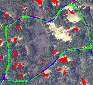
Figure 3: Combined data.
RED: From Impervious Surface dataset only
GREEN: From Buffered Roads dataset only
BLUE: From Both Impervious Surface and Buffered Roads datasets
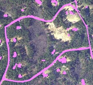
Figure 4: Final dataset, with Impervious and Buffered Roads compressed to binary dataset. In this sample, the pink are the Impervious areas (pixel value 1). The non-Impervious areas (pixel value 0) are drawn transparently, allowing the ortho image to show through.
What MassGIS distributes
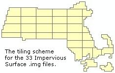
Because the entire statewide dataset totals almost 4.5 GB in size, MassGIS has chosen to tile the data for easier distribution and file handling. The data, in Erdas Imagine (.img) file format, have been broken up into 33 pieces based on the 2005 Color Ortho Mosaic Index. The individual tiles have been highly compressed into .zip files that range in size from 2.7 MB to 25 MB. Once uncompressed, the Imagine files range in size from 80 MB to 130 MB.
There is no vector format for this data.
Maintenance
MassGIS maintains the layer. No updates are planned.