Downloads
Overview

The Massachusetts Division of Fisheries and Wildlife interior forest GIS dataset identifies extensively forested portions of the Massachusetts landscape where forest cover is relatively un-fragmented by human development. Other natural features such as wetlands and open water are included in this dataset as non-fragmenting features. The dataset was initially developed by DFW with input from The Nature Conservancy for use by Massachusetts state agencies to facilitate the selection of forest reserves on state-owned lands in the Commonwealth, and subsequently has been used by DFW when evaluating parcels of land for potential public acquisition. The dataset has no regulatory associations or intentions and is subjective in nature.
Although the initial data analysis for this data layer has been completed, land use changes continually and this data layer is therefore considered to be under development.
Notice:
The Interior Forest data layer is currently based on the 1999 MassGIS Land Use data layer.
MassGIS stores and distributes the layer as INTERIORFOREST_POLY.
Source Data and Production
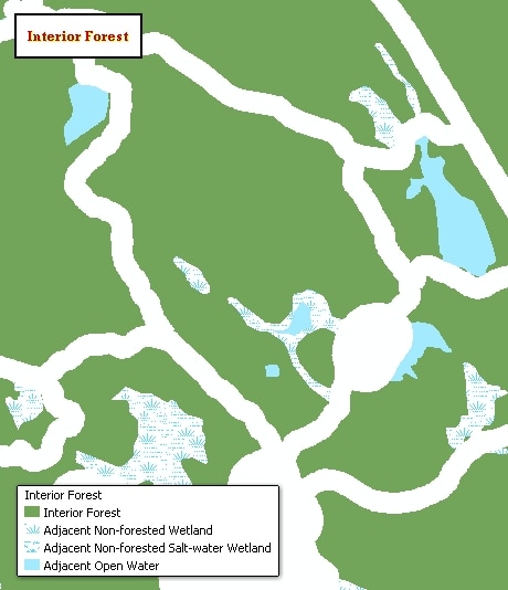
The dataset was created using the Massachusetts Highway Department Roads data (2003), MassGIS Land Use data (1999), and Boston Transportation Planning Organization's Trains data (2004). Land use classes considered natural features were extracted and converted to a new coverage, including forest, wetland, and open water. Although wetlands and open water are not considered interior forest, in most cases they were considered non-fragmenting natural features in a landscape context and were left in for the initial analysis. Roads were separated into three classes: class 1 roads were buffered at 1000m, classes 2,3,4,7 were buffered at 300 m, and classes 5 and 6 were buffered at 100 m. Rail lines were buffered at 300 m. Fragmenting buffer widths were based partially on work done by The Nature Conservancy, Boston Office (Forman, R.T.T., and R.D. Deblinger. 2000. The Ecological Road-Effect Zone of a Massachusetts, USA Suburban Highway. Conservation Biology 14:36-46). All fragmenting land use categories were extracted, converted to a new coverage, and buffered at 300m. The road, trains, and fragmenting land use buffers were then merged into the non-fragmenting natural features. Once complete, the buffers were extracted and deleted from the coverage, leaving polygons considered to be "interior natural features." Clean and build functions were then run to eliminate sliver polygons and artificial boundaries, such as town lines, that split areas of interior natural areas. Wetland and open water polygons were left in the dataset to keep data analysis flexibility for conservation uses. The coverage was then converted to shapefile format for distribution.
The first update (version 1.1) consisted of the removal of additional artificial separations between interior forest polygons, such as a town boundary that split an interior forest block into two separate polygons. All interior forest polygons were selected and converted to a new shapefile. The new shapefile was then put in edit mode, and all polygons were unioned in arcview 3.2 to make one single polygon. The new polygon was visually checked to be sure errors were removed. Then the xtools function was used to convert the multipart polygon to separate polygons. The number of interior forest polygons was reduced from 5,466 (599,759 ac total) to 5,213 (599,902 ac total). The increase in acres may be due to the reduction of gaps between forested polygons.
A second update (version 1.2) to the interior forest layer was undertaken in June, 2008. The prior drafts allowed wetlands and water bodies to "split" forest blocks into smaller blocks of forest. We wanted areas of contiguous forest and wetland/water body to remain as one "natural block". The following steps were taken to improve the interior forest shapefile in that way: 1) All directly adjacent polygons (3,4,14,and 20) from intfor_v1_1.shp were dissolved into "natural blocks" regardless of the land use type. 2) All polygons less than 50 acres were then removed from the resulting shapefile. 3) Several statistics were generated at the "natural block" level and are preserved as attributes in the interior forest shapefile. Please see the attribute metadata for details. 4) Then unioned the wetlands and waterbodies back into the shapefile (4, 14, and 20). This allowed us to calculate the acres in each block that were not forested and isolate those non-forested polygons. The union also kept the forested portion of each natural block as one polygon or multi-part polygon, even if the wetlands/water bodies split the forested portion. This was a good use of multi-part polygons and we have preserved that data structure in the current shapefile. 5) We finally removed all of the natural blocks that had less than 50 acres of forest present in the natural block. For instance, if the total area was 200 acres broken down into 160 acres of wetland/water body and 40 acres of forest, we removed both the forested and wetland/water body portions of the natural block. 6) Several additional attributes were added after the union of wetland and water body polygons into the shapefile. See the attribute descriptions for details.
Selection of the lower threshold of 50 acres was informed by a quick review of minimum interior forest patch size requirements online. While not regionally appropriate, in Southern Ontario, patches of 200 hectares (roughly 500 acres) are thought to be the minimum size for a forest ecosystem to recover from disturbance events such as hurricanes (wind-throw), fires, or insect/disease infestations (Forest Fragmentation Fact Sheet, Federation of Ontario Naturalists). This threshold seemed high given that some interior forest species, such as the Scarlet Tanager have sliding requirements of minimum forested patch size. They can occur in patches as small as 21 acres if the surrounding landscape is at least 70% forested. This minimum patch size quickly increases as the overall percent of forest decreases in the landscape. In a landscape that is 60, 50, and 40% forested the minimum patch size is 62, 172, and 476 acres respectively (Cornell Laboratory of Ornithology, Improving Habitat for Scarlet Tanager and other Forest-interior birds, Atlantic Coast Region. The selection of the 50 acre threshold lies in the lower portion of the range for this species.
Finally, resulting polygons were intersected with Harvard Forest’s data layer of Known 1830s forest polygons and with parcels protected by a Massachusetts state conservation agency from the February 2008 MassGIS Open Space data layer to generate acreages for those two related resource values for each interior forest polygon.
Attributes
The datalayer's polygon attribute table has the following items:
| ITEM NAME | WIDTH | TYPE | DESCRIPTION |
|---|---|---|---|
| LEVEL1_ID | 4 | I | An ID that uniquely identifies each contiguous "natural block" of forest, wetland, and water bodies. |
| LEV1_ACRES | 19 | F | Total acres in each "natural block" |
| LEV1_PERIM | 19 | F | Perimeter (meters) of each natural block |
| LEV1_SQ_M | 19 | F | Area (square meters) of each natural block |
| LEV1_AP_RA | 19 | F | Area to perimeter ratio in each natural block |
| ACRES_1830 | 19 | F | Acres of known 1830s forest present in each natural |
| ACRES_FOR | 19 | F | Acres of forest present in each natural block |
| NMLD_ACRES | 19 | F | An index value between 0 and 1 that normalizes the total acres in each natural block. Calculated by taking the acres in each natural block and dividing it by the acres in the largest natural block in the state. |
| NMLD_APRA | 19 | F | An index value between 0 and 1 that normalizes the area to perimeter values in each natural block. Calculated by taking the AP value in each natural block and dividing it by the largest AP ratio out of all the natural blocks (the most evenly shaped). |
| NMLD_1830 | 19 | F | An index value between 0 and 1 that normalizes the 1830s forest in each natural block. Calculated by taking the acres of 1830s forest in each natural block and dividing it by the acreage of 1830s forest in the block that has the most 1830s forest. |
| NMLD_FOR | 19 | F | An index value between 0 and 1 that normalizes the acres of forest in each natural block. Calculated by taking the acres of forest in each natural block and dividing it by the acres of forest in the block in the state with the largest amount of forest. |
| LU99_CODE | 5 | I | Land use code for each polygon (3 = forest, 4 = wetland, 14 = salt wetland, 20 = open water) |
| LEV2_ACRES | 19 | F | Acreage in each polygon after the wetland and water body polygons were unioned back into the shapefile. Each wetland and water body is a distinct polygon. If a wetland or water body split a natural block the remaining forested portions are all part of one multi-part polygon. |
| ST_PROT_AC | 19 | F | Acres of forest in each natural block that are protected by state conservation agencies (DFG or DCR fee ownership or DFG or DCR CR holding) |
| UNPR_RATIO | 19 | F | (ACRES_FOR - ST_PROT_ACRES)/ACRES_FOR |
| FOR_RATIO | 19 | F | ACRES_FOR/LEVEL1_AC |
Maintenance
DFW maintains the layer and will provide any updates to MassGIS.