Downloads
Zipped download file includes:
- DEM as a file geodatabase raster dataset
- Shaded relief image in JPEG 2000 format
- ArcMap 10 (.lyr) and ArcGIS 2.9 (.lyrx) layer files
Overview
MassGIS has created seamless, statewide imagery layers from the Legacy Lidar Terrain Data. The datasets include:
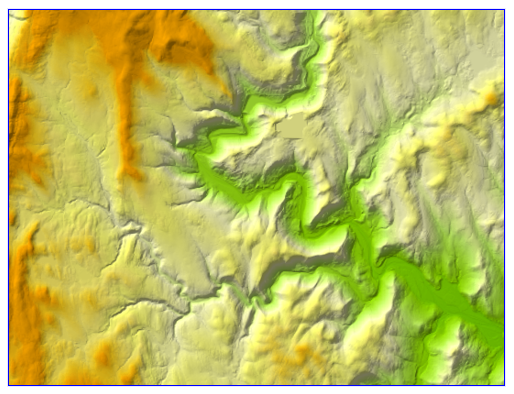
Digital elevation model
This bare earth digital elevation model (DEM) represents the elevation of the surface with vegetation and structures removed. The spatial resolution of the DEM is 1 meter. The elevation of each 1-meter square cell (pixel) was linearly interpolated from classified lidar-derived point data. This version of the DEM stores the elevation values as integers in both feet and meters.
This DEM is referenced to the WGS_1984_Web_Mercator_Auxiliary_Sphere projection.
In MassGIS' VWP Oracle database, the layer is named GISDATA.IMG_ELEV_LIDAR_INT.
Shaded relief
This shaded relief image was generated from the lidar-based bare-earth DEM. A shaded relief image provides an illustration of variations in elevation using artificial shadows. Based on a specified position of the sun, areas that would be in sunlight are highlighted and areas that would be in shadow are shaded. In this instance, the position of the sun was assumed to be 45 degrees above the northwest horizon.
The shaded relief image shows areas that are not in direct sunlight as shadowed. It does not show shadows that would be cast by topographic features onto the surrounding surface.
In MassGIS' VWP Oracle database, the layer is named GISDATA.IMG_SHADEDRELIEF_LIDAR.
Production
Using ERDAS IMAGINE, MassGIS combined the tiled lidar DEMs in the western (UTM zone 18) and eastern (UTM zone 19) parts of the state into two mosaics. In ArcGIS Desktop 10.7.1, these were merged to one statewide file geodatabase raster dataset and projected to WGS84.
In the statewide DEM, the VALUE field represents the elevation above/below sea level in meters. MassGIS added a FEET field to the VAT (value attribute table) to store the elevation in feet as calculated by multiplying VALUE x 3.28084 and rounding it to the nearest integer.
Dates of the primary lidar data used in this DEM range from 2010-2015. The overlapping lidar projects were adjusted to the same projection and datum and then mosaicked, with the most recent data replacing any older data. Several very small gaps between the project areas were patched with older lidar data where necessary or with models from recent aerial photo acquisitions. See the index map for details.
The index map is based on the LIDAR_PROJ field in the LIDARDEMSOURCES_POLY feature class.
>> Download the index (shapefile and Arc layer file; 18 MB)
>> View the index in MassMapper
To create the shaded relief image, a 3x3 neighborhood around each pixel in the DEM was analyzed, and a comparison was made between the sun's position and the angle that each pixel faces. The pixel was then assigned a value between -1 and +1 to represent the amount of light reflected. Negative numbers and zero values represent shadowed areas, and positive numbers represent sunny areas. Once the eastern and western relief images were created in ERDAS IMAGINE, they were merged using ArcGIS Desktop 10.7.1 and the statewide mosaic was converted to a JPEG 2000 format with values from 0 (black) to 255 (white) and saved in the NAD 1983 Mass. State Plane Mainland Meters (Fipszone 2001) projection.
Displaying the data
The ArcGIS Pro layer file included with the download at the top of the page was created using a custom color ramp for the DEM. The shaded relief image was displayed atop the DEM with 45% transparency and the Multiply layer blending mode. The ArcMap layer file uses a similar custom color ramp for the DEM and a semi-transparent shaded relief image.
Aside from the downloads at the top of the page, the shaded relief image is available as a hosted tile layer at ArcGIS Online and as an image service from MassGIS' ArcGIS Server platform. The DEM is available as an image service from MassGIS' ArcGIS Server. A tile layer (cache) that combines the two layers uses the ArcGIS Pro symbology and may be accessed in ArcGIS Online and MassMapper. The image services give the user more control to adjust the display properties (stretching, color ramps, etc.) compared to tile layers.
The Massachusetts Elevation Finder uses the combined tile layer for display and the DEM image service for identifying elevation values.
Maintenance
No updates are planned for these legacy datasets. See the current Lidar Terrain Data page for newer products.