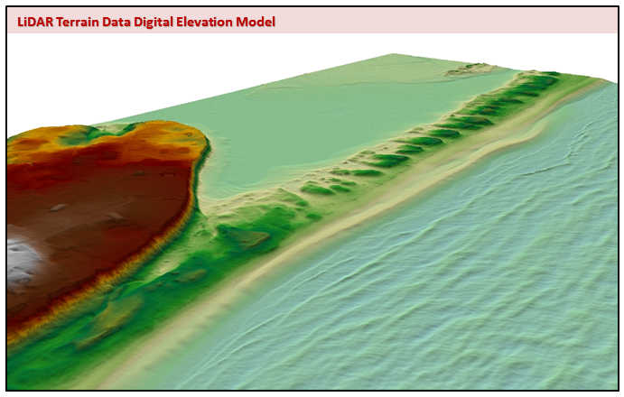
Overview

These data can be used for emergency response, drainage studies and hydrologic / floodplain modeling, development suitability analysis and infrastructure planning, identification of structures and other man-made features, habitat classification, vegetation mapping, and many other purposes.
Organized into eight delivery area datasets, each represents a distinct data acquisition project with unique characteristics.

>> View Project Area Index Map (PDF) (based on the Legacy Lidar Index layer).
Acquisition dates range from 2010 to 2014, and a variety of agencies and/or partnerships sponsored these missions; details can be found in the project-specific metadata. Differences among the projects include the instruments used to acquire the data, processing software, accuracy, point spacing, format, projection, tiling schemes, and availability of derivative products such as contours and breaklines.
Data derived from the original Lidar acquisition are available for each project area in two sets of products:
- Point data are in binary LAS files.
- Raster DEMs (digital elevation models) in GeoTiff (.tif) or Erdas IMAGINE (.img) format.
The horizontal datum for all data is NAD83; the vertical datum is NAVD88.
Federal agencies are the primary contributors of the newer data. See the USGS' 3D Elevation Program page for an abstract and a link to a summary report for Massachusetts.
Project Areas
The following table summarizes data for the projects and contains links to download full project-specific metadata:
| Year / Project Name | Acquisition Dates | Projection / Units | ** DEM Size / Resolution | ** LAS Point Size | * Full Metadata |
|---|---|---|---|---|---|
| 2013-2014 Sandy | Fall 2013 & Spring 2014 | UTM Zone 18N & 19N Meters | 4.67 GB 1 m (.img) | 121 GB | ZIP 2 MB |
| 2012 Merrimack Watershed | Nov. 2011-Jan. 2012 | UTM Zone 19N Meters | 1 GB 1 m (.tif) | 4.4 GB | ZIP 26 MB |
| 2011 Northeast | Winter-Spring 2011 | UTM Zone 19N Meters | 17.5 GB 1 m (.tif) | 184 GB | ZIP 18 MB |
| 2011 Nashua River | May 6-7, 2011 | UTM Zone 19N Meters | 3.14 GB 1 m (.tif) | 26.7 GB | ZIP 69 MB |
| 2010 Blackstone River | Dec. 15-17, 2010 | UTM Zone 19N Meters | 1.18 GB 1 m (.tif) | 10.3 GB | ZIP 77 MB |
| 2010 Charles River | Dec. 2-11, 2010 | UTM Zone 19N Meters | 1.93 GB 1 m (.tif) | 19.4 GB | ZIP 86 MB |
| 2010 Concord River | Dec. 2-12, 2010 | UTM Zone 19N Meters | 2.95 GB 1 m (.tif) | 28.8 GB | ZIP 60 MB |
| 2010 Narragansett River | Dec. 8-10, 2010 | UTM Zone 19N Meters | 1.86 GB 1 m (.tif) | 19 GB | ZIP 29 MB |
* Metadata .ZIP files include an overview text file and various documentation (PDFs, Word docs, and text files on acquisition, processing, QA, etc.) as delivered to MassGIS. Metadata varies by project area.
** DEM and Point file sizes represent the sum of all files as bzip2 or laz compressed archives for a project area and are provided to aid in downloading the data. The data file sizes will be larger when uncompressed, which is necessary in order to use the files in GIS and other software. Files sizes of individual rasters differ among and within project areas.
Legacy Lidar Products

MassGIS distributes the following products.
Data by tile
- LAS Point Data: NOAA hosts most of our LAS data, which can be accessed for FREE through its NOAA Data Access Viewer. Go there to get ground-classified .las files. LAS files represent a "point cloud," the three-dimensional composite of all returns from all laser pulses as determined from the aerial mission. These returns are analyzed to identify those that were probably reflected from the ground. Use the Fugro Viewer for viewing both LAS point files and the raster GeoTiffs, as well as shapefiles for referencing. We also recommend the free and open source QGIS Software
- Bare-earth Digital Surface Model (DSM) rasters (aka DEMs) in GeoTIFF and ERDAS Imagine formats, tiled to correspond to the .las files. These rasters were either provided to MassGIS as a project deliverable or created by MassGIS from the ground-classified points. In this context, DSM refers to a "bare earth" DEM raster dataset without buildings or vegetation. In cases where MassGIS created a DEM where none was delivered, any return with a .las GROUND classification was converted to a multipoint feature class, and then to a Terrain in ESRI ArcGIS 10. Breaklines representing various water features were included in the Terrain where available. The Terrain was then linearly interpolated to a floating-point .img raster. Finally, this large image dataset was “diced” into GeoTIFF tiles appropriate for each project.
To Download the DEMs for the project areas listed above:
- Open MassMapper and use the Identify tools to select your area of interest.
- In the Identify results box click on the layer 'Legacy Lidar Index'. The Feature details section will display the link for each tile you selected. Click on each link to download a .zip file containing the DEM.
- To download many images in a more automated way, click the 'Save all records as' dropdown and save to an Excel file. Then:
- Open Excel or a similar spreadsheet program, copy only the cells with the links and paste them into Notepad or other text editor and save as a text file.
- Download the free WinWGet software and load the text file into a new job. Run the job and all the zipped images will be downloaded to a folder you choose.
The illustrated instructions on the download process for the Lidar DEMs are identical as those for the 2019 Aerial Imagery.
Note about downloading .bz2 files in Internet Explorer:
MassGIS recommends using the Firefox, Chrome, or Safari web browsers to download the bzip2 compressed GeoTiff raster DEMs. If using Internet Explorer, when you click on a download link IE may attempt to display the binary contents of the file rather than prompt for downloading it. As a workaround in IE, right-click a .bz2 file, choose Save Target As..., and in the Save As dialog, choose "All Files" from the 'Save as type' dropdown. Then, in the "File name" box, change the .htm extension to .bz2 and click Save. When using Firefox, Chrome or Safari (the three browsers in addition to IE that MassGIS tested), you simply need to click on the .bz2 link and you will be prompted to download the file.
Notes:
- Lidar flight lines are frequently aligned with the terrain.
- For flood mapping, Lidar data may only have been processed near rivers and streams or along coastlines.
Statewide imagery
MassGIS has created seamless, statewide imagery layers from the Legacy Lidar Terrain Data. The datasets include:
- Digital elevation model (DEM) - This bare earth digital elevation model (DEM) represents the elevation of the surface with vegetation and structures removed. The spatial resolution of the DEM is 1 meter. The elevation of each 1-meter square cell (pixel) was linearly interpolated from classified lidar-derived point data. This version of the DEM stores the elevation values as integers in both feet and meters.
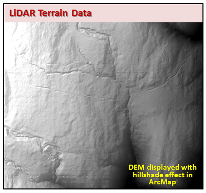
- Shaded relief - This hillshade image was generated from the lidar-based bare-earth DEM. A shaded relief image provides an illustration of variations in elevation using artificial shadows. Based on a specified position of the sun, areas that would be in sunlight are highlighted and areas that would be in shadow are shaded. In this instance, the position of the sun was assumed to be 45 degrees above the northwest horizon.
See the Legacy Lidar DEM and Shaded Relief page for more details and links to data download.
Using the DEMs in GIS Software
Unzipping .bz2 Files
The GeoTiff and IMG DEMs are provided for download in bzip2 compressed file format. The .bz2 files were created using the free and open source bzip2 1.0.6 software. Each .tif or .img file must be extracted from its .bz2 file by using a compression utility such as the free and open source 7-Zip and bzip2 software, or any tool that recognizes the .bz2 file format. Most Linux and Unix systems have bzip2 installed or have it included in their installation media.
Creating Pyramids and Statistics
To keep the file sizes as small as possible, the .bz2 downloads do not include accompanying pyramid or statistics files for the GeoTiffs and IMGs. When loading the .tif or .img into ArcMap, for example, the user may be prompted to build pyramids in order to speed image display.
More importantly, when first displaying the image it may appear as a single shade of gray, an artifact of the image not having statistics. To correct this, the image must be stretched (in the layer's Properties > Symbology tab > Stretch section in ArcMap). Since image stretching requires statistics, the user may be prompted to compute statistics when choosing a stretch method. When applied, the image will then display as expected. See the document Lidar Image Stretching for illustrated details.
Want to learn more about LiDAR?
A good place to start is the USGS Lidar base specification report.
| Date published: | March 2, 2023 |
|---|---|
| Last updated: | March 2, 2023 |