Downloads
Overview
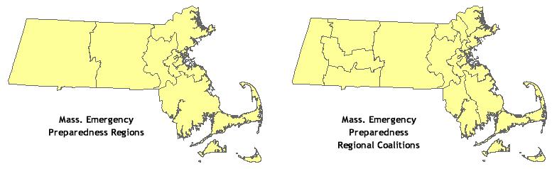
These two statewide boundary layers are used by the Bureau of Environmental Health (BEH), Massachusetts Department of Public Health (MDPH) for planning and administrative purposes. The source material for these datalayers was compiled by Christina Kara, Emergency Preparedness Bureau, MDPH. The two layers are:
- Emergency Preparedness Regions - REGDPHEP_POLY
- Emergency Preparedness Regional Coalitions - REGDPHEPC_POLY. Regional coalitions belong to larger Emergency Preparedness Regions.
Updated in August 2021 to be based on the Survey Towns Boundaries (previously based on the USGS-based town boundaries).
Production
Staff at the GIS Program, Bureau of Environmental Health, Massachusetts Department of Public Health developed the data. In Access 2000, the Regional Coalition information was joined to the attribute table of the MassGIS Municipalities datalayer based on town name. Using ESRI's ArcMap 9.0 software, a dissolve was performed on the Community Boundaries layer on Regional Coalition name. The new feature class was renamed. In Access 2000, the Region field was manually inserted into the attribute table using the original Regional Coalition information as a reference. To produce the Regions layer, polygons were created based on a dissolve on the Region field in the Coalition layer.
Attributes
Both polygon layers have the field REGION, which is the MDPH Administrative Region Name. The Coalitions layer also has the field REG_COAL, which is the MDPH Administrative Regional Coalition Name.
Maintenance
MDPH maintains these layers. Users should direct questions to:
Massachusetts Department of Public Health, Bureau of Environmental Health
250 Washington Street, 7th Floor
Boston, MA 02108
(617) 624-5757 (Voice)
(617) 624-5777 (Fax)
MassGIS updated these layers in April 2022 to reflect recent edits to the Municipalities layers.