Downloads
Overview
The table is intended to provide municipalities, residences, businesses, and application developers with a comprehensive list of standardized addresses for cities and towns throughout the Commonwealth. The table leverages the work done by MassGIS of compiling, standardizing, maintaining and editing addresses for the Next Generation 911 system project.
Address sources include the Voter Registration List from the Secretary of the Commonwealth, site addresses from municipal departments (primarily assessors), and customer address lists from utilities. Addresses from utilities were “anonymized” to protect customer privacy. The MAD was also validated for completeness using the Emergency Service List (a list of land line addresses) from Verizon. There is no spatial geometry in this data product.
MAD addresses have been normalized and standardized and are in the process of being cleaned up. Part of the cleanup process involves linking records that are currently in our Master Address table as distinct addresses but, in actuality, are one and the same. An example of this kind of error is "14 MAIN STREET Unit 2" and "14 MAIN STREET 2nd Floor". In this case, the unit and floor values are intended to be the same and these records should be aggregated in the Master Address table.
Although the address list is derived from many sources and we have tried to make the list as comprehensive as possible, some address will still be missed. These missing addresses are a reflection of the source information. If an address is not in the Voter Registration List, the Emergency Service List or Assessing data, then it may be left out. Typical missing addresses include:
- Addresses associated with unit information: e.g. we have "14 MAIN ST" but are missing "14 MAIN ST Unit 1"
- Addresses associated with duplexes: e.g. we have "14 A MAIN ST" but are missing "14 B MAIN ST"
- Addresses associated with businesses, strip malls in particular
In the MAD, address records are being flagged where we are not confident in the validity of their existence. These low confidence records are excluded from this data product. MassGIS staff are reviewing such points in the field as part of a "Field Data Capture" (FDC) project.
The Basic Address List is an export from the view named MAD.MADQT_BASIC_ADDR in MassGIS' ArcSDE (VWP instance) database.
The Basic Address List is different from the Advanced Address List in that the Advanced list contains unit information and an ID that is used within the MAD. This ID can be used to synchronize with the MAD, facilitating the identification of new records between exports and allowing for the import of local data into the MAD.
Data are available from MassGIS for all cities and towns except Boston. For Boston, the Boston Street Address Management (SAM) Addresses may be downloaded from the BostonMaps Open Data site in a spreadsheet.
Attributes
The Basic Address List contains the following fields:
| Name | Type / Length | Description |
|---|---|---|
| ADDRESS | String / 200 | A concatenation of ADDR_NUM, a space and STREETNAME. |
| ADDR_NUM | String / 30 | The standardized version of the complete address number retrieved from a parsed address or pre-parsed address number components. Derived from FULL_NUMBER_STARDARDIZED value in MAD_MASTER_ADDRESS. |
| STREETNAME | String / 166 | Standardized street name. |
| REL_LOC | String / 80 | Standardized relative location information relative to either the address, the street referenced by the address, or both. Common values include 'OFF', 'REAR', 'NEAR', 'BEHIND' etc. |
| SITE_NAME | String / 200 | Standardized name of site. (i.e. 'BRIARWOOD CONDOMINIUMS' or 'HARVARD UNIVERSITY'. |
| BUILDING | String / 100 | Building designation or a formal building name if it has one. (i.e. 'A' from BLDG A, UNIT 1 or 'MUGAR SCIENCE CENTER') |
| TOWN | String / 21 | Official municipality name. |
| TOWN_ID | Small Integer / 5 | Unique ID for a municipality. |
| ZIPCODE | String / 10 | Address ZIP Code (likely derived from ZIP+4 and MSAG/street name lookup or HERE data, not necessarily the address' original source material). |
| STATUS | String / 30 | The addresses status in regards to its association with any address multipoint, reviewability, recent edits, or obsolescence. |
Domains for STATUS (Address Status):
| ACTIVE | Address is assigned to an address point. |
|---|---|
| INACTIVE | Address was previously active, but is no longer in use. May or may not have been replaced with a new address. |
| UNASSIGNED | Address not yet assigned to an address point. |
| SITE_REVIEW | Address belongs to a site and requires review before becoming ACTIVE as the address can probably be further disaggregated to the building level. |
| REVIEW | Address requires review before becoming active (for any reasons other than site disaggregation). |
| NOT_FOUND | Address underwent review and a geographic location for it could not be found. |
| PARENT | Address record is temporary and represents an aggregation of other unit-specific addresses. This record's MASTER_ADDRESS_ID is equal to its PARENT_ADDRESS_ID. |
| MODIFIED | This address record is active and had one or more address component fields edited during FDC/local review. |
| ADDED | This address record represents an address that was added as a new or missing address identified during FDC. It should not have an address point ID. |
| UNLINKED | The address point ID previously associated with this address record was removed during FDC/local review (but edit may have been overridden). |
| LINKED | This address is active and was associated with a non-geocoded address point during FDC/local review. |
Street Name Notes
Some street names in the Basic Address List view include appended values that follow the format Street Name (Place Name). The place names fall into three categories:
- Adjacent Town: When a structure is on or near a town boundary and the address for that structure is associated with a street in an adjacent town, the adjacent town name will be appended to street name. See the example Addresses in Your Town, Street in Adjacent Town below.
- MSAG Community: During the implementation of E9-1-1 in the early 1990s, towns were encouraged to manage their addresses so that the combination of the address number, street name and town name were unique. Almost all towns complied and most of the duplicate addresses were eliminated. In most cases, towns changed the street name in order to keep addresses unique, but eleven towns chose to manage their duplicates by using community values. The community value is the name of the Master Street Address Guide (MSAG) Community in which the respective street occurs. (The MSAG is a comprehensive list of all street names used in the 911 system). Cities and towns that have these MSAG Communities are Barnstable, Boston, Deerfield, Dennis, Nantucket, Northampton, Palmer, Springfield, and the three towns (Ayer, Harvard and Shirley) in which Fort Devens is located. The MSAG Community names are appended to the street name for these cities and towns and are included strictly to maintain the uniqueness of streets. See the example Village Names below for further explanation.
- Neighborhood: There are rare cases where duplicate street names still exist and are not covered by the use of MSAG Community. In these cases, MassGIS adds a Neighborhood value in order to ensure uniqueness within the MAD. Where the Neighborhood name is not null it is appended to the street name. See the example Neighborhood Names Used to Differentiate Duplicate Streets below for further explanation.
In no case is there more than one place name value appended to a street name.
Examples
Addresses in Your City/Town, Street in an Adjacent City/Town
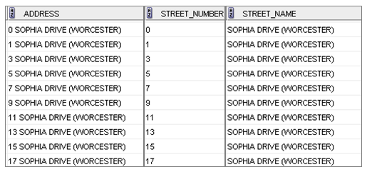
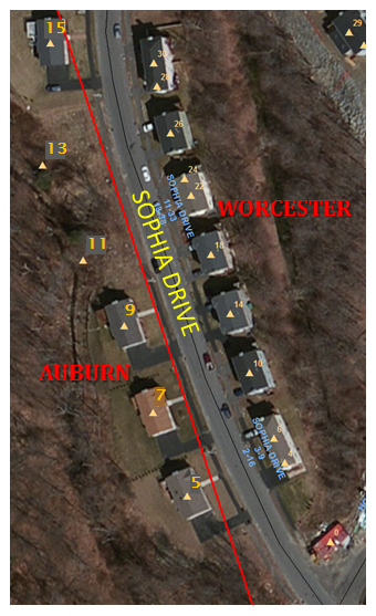
The downloadable Address Export product will append the value of an adjacent city or town name to the Street Name and Address fields where an address is located in the queried city or town but the street is geographically within an adjacent city or town. An example of this is Sophia Drive in Auburn. There are addresses along Sophia Drive where the houses are clearly within Auburn but Sophia Drive is geographically in Worcester. In this case, ‘(Worcester)’ is appended to the Street Name and Address fields to indicate that the street is in the adjacent city.
Village Names
Village name is another value that is sometimes appended to the Street Name and Address fields. Because the MSAG was one of the primary sources used in the creation of the streets database, MSAG Community values are available and are sometimes necessary to keep addresses unique. Cities and towns that have these MSAG Communities are Barnstable, Boston, Deerfield, Dennis, Nantucket, Northampton, Palmer, Springfield, and the three towns (Ayer, Harvard and Shirley) in which Fort Devens is located. MSAG Community values do not represent a comprehensive listing of the villages for that town. Because their sole function was to keep street names unique, they were only created where there was ambiguity in regards to duplicate streets. So, some villages will not be represented in the names appended to streets in the Address Export product. For example, the village name Allston is not an MSAG Community name in Boston; Allston addresses are lumped in with Brighton, which is an MSAG Community. Another example of this is the village of East Dennis, which is not an MSAG Community in Dennis.
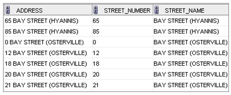
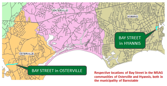
In Barnstable, there are two Bay Streets, one in the village of Hyannis and the other in Osterville. Both of these village names are MSAG Communities in Barnstable and are shown in this example from the Basic Address table:
Neighborhood Names Used to Differentiate Duplicate Streets
A Neighborhood value can also be appended to the Street Name and Address fields. In the vast majority of cases, the combination of address number, street name and community values keep an address unique. There are, however, a few cases where this is not true. To resolve this issue, MassGIS has added a Neighborhood value to keep the addresses distinct from each other. An example where the neighborhood value is appended is Elm Avenue in Bourne.
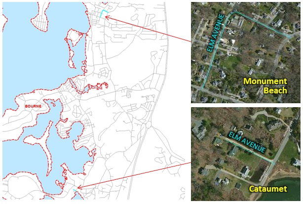
There are two Elm Avenues in Bourne that are completely separate from each other and have overlapping address ranges; the two Elm Avenues are selected in the image above. In order to keep the addresses distinct, neighborhood values of Cataumet and Monument Beach were appended. Neighborhood values are determined from USGS topological maps or local sources.
Reporting Errors and Omissions
Address assignment is a responsibility of municipal government. MassGIS cannot update the MAD unless the update comes from an appropriate municipal source. If users have address information that is not included in this product or they see errors in the data, they should contact the department in the relevant municipality responsible for tracking official addresses and for distributing address updates. Refer to a List of Address Authority Departments in each city and town for how to contact individual municipalities. If the address error or omission is confirmed by the municipality, the community’s addressing authority should notify MassGIS. Updates from municipalities are incorporated into the MAD and will appear in future address file downloads. All municipalities have been contacted concerning how to notify MassGIS of new or changed addresses as part of ensuring all their addresses are included in the NextGeneration 911 system. If the addressing authority is not familiar with how to notify MassGIS of new addresses or address errors, they can ask MassGIS how to submit this information.
Maintenance
MassGIS is actively updating these data and the downloadable files are refreshed weekly.