Downloads
Overview
This product is intended to provide municipalities, residences, businesses, and application developers with a comprehensive set of standardized address points for cities and towns throughout the Commonwealth.
This point dataset leverages the work done by MassGIS of associating addresses with their respective locations for the State 911 Department’s Next Generation 911 system project. The data can be used for a variety for purposes, including incorporation into a municipal master address database, geocoding and other address location functions, quality control, and incorporation into computer aided dispatches (CADs).
This export is considered "basic" because values such as street name and town name have been added as attributes of the point geometry, the geometry represents simple points instead of more complex multipoints, and it has a reduced number of address record fields compared to the information in the full MAD database.
The Basic Address Points feature class is named MAD.MADQF_ADDRESS_POINTS in MassGIS' ArcSDE (VWP instance) database. It is exported weekly from the spatial view MADQV_ADDRESS_POINTS, which was created using the geometry from MAD_ADDRESS_POINTM_CENTROID.
Data are available from MassGIS for all cities and towns except Boston. For Boston, the Boston Street Address Management (SAM) Addresses (points) may be downloaded from the BostonMaps Open Data site.
Methodology
Within the MAD database, structure-based address points are natively maintained as a multipoint feature class (MAD_ADDRESS_POINTM), in which each structure greater than 150 square feet is represented by a point, and all of the points associated with one address are aggregated into one multipoint. Centroids were created from the multipoints, with one centroid per address. Where the multipoint represents a single structure, the centroid is coincident with the basic address point. Where the multipoint is representative of multiple structures, the centroid is spatially weighted towards the largest structures associated with that address. Nearly every structure identified by MassGIS is represented in this basic address point product. Points based on structures can be identified using the POINT_TYPE field. See the domain value documentation below.
Address points were also created from standardized Property Tax Parcels Where a parcel exists but does not contain a known structure, the centroid of that parcel was added to the Basic Address Points dataset to carry the parcel’s address value. These points have a POINT_TYPE value of 'PC'.
MADQT_ADDRESS_POINTS includes "stacked points". Whenever more than one address is associated with a single centroid, the address points are stacked, meaning each unique address associated with a structure, or group of structures, will have a distinct point with identical geometry to the other addresses assigned to the same structure(s). Typical examples of this are condominiums where several units can be within a single structure.
Address information in the Basic Address Points product were derived from the MAD table MAD_MASTER_ADDRESS. Sources of MAD_MASTER_ADDRESS include the Voter Registration List from the Secretary of the Commonwealth, site addresses from municipal departments (primarily assessors), and customer address lists from utilities. Addresses from utilities were “anonymized” to protect customer privacy. The MAD was also validated for completeness using the Emergency Service List, a list from Verizon of the addresses associated with active landlines.
MAD addresses have been normalized and standardized and are in the process of being cleaned up. Part of the cleanup process involves reconciling records that are currently in our Master Address table as distinct addresses but, in actuality, are one and the same as an existing address. An example of this kind of error is 14 MAIN STREET Unit 2 and 14 MAIN STREET 2nd Floor. In this case, the unit and floor values are intended to be the same and these records should be aggregated in the Master Address table.
Approximately 96% of the addresses within the Emergency Service List have been mapped, but there are still many addresses missing from the MAD. These missing addresses are a reflection of the source information. If an address is not in the Voter Registration List, the Emergency Service List or Assessing data, then it may be left out. Typical missing addresses include:
- Addresses associated with unit information, e.g. we have 14 MAIN ST but are missing 14 MAIN ST Unit 1
- Addresses associated with duplexes, e.g. we have 14 A MAIN ST but are missing 14 B MAIN ST
- Addresses associated with businesses, particularly those in strip malls
Attributes
The Basic Address Points feature class contains the following fields:
| Name | Type / Length | Description |
|---|---|---|
| OBJECTID | OID / 38 | ESRI geodatabase unique ID for each feature. |
| ADDR_PT_ID | String / 20 | Unique ID of associated address multipoint in MAD_ADDRESS_POINTM. Composed of its (or its centroid's) concatenated XY integer coordinates in MA State Plane meters. |
| X | String / 20 | X (east/west) coordinate of the point in NAD83 Mass. State Plane meters. |
| Y | String / 20 | Y (north/south) coordinate of the point in NAD83 Mass. State Plane meters. |
| POINT_TYPE | String / 10 | The origin and nature of the address multipoint, especially distinguishing between structure vs. non-structure origins, and single vs. multiple structures. See the domain values below. |
| LOC_ID | String / 20 | Location ID of the parcel in which the point is located. Formatted with X and Y Mass. State Plane coordinates of the parcel centroid as: M_<X>_<Y> (meters) or F_<X>_<Y> (US Survey Feet); |
| ADDRESS_ID | Long Integer / 10 | Unique ID for a standardized address record. Generated via sequence and trigger. |
| NAD_ID | String / 38 | Unique address ID in GUID format for National Address Database. |
| ADDR_NUM | String / 30 | Standardized address number of the address. May be a range and/or contain characters indicating prefixes and suffixes. |
| STREETNAME | String / 80 | Standardized street name. |
| REL_LOC | String / 80 | Standardized location-style information relative to either the address, the street referenced by the address, or both. Common values include 'OFF', 'REAR', 'NEAR', 'BEHIND', etc... |
| SITE_NAME | String / 200 | Standardized name of site (e.g. MIDDLESEX FELLS RESERVATION for THE FELLS). |
| BUILDING | String / 50 | Building designation or formal building name if it has one (e.g. 'A' from 'BLDG A, UNIT 1', or 'MUGAR SCIENCE CENTER'). |
| WING | String / 50 | Standardized value of subaddress information portion of an address representing a 'Wing' designation. (i.e. 'EAST WING' from 'MUSEUM OF INTERESTING ART, EAST WING, ANTIQUITIES ROOM') |
| FLOOR | String / 30 | Standardized value for the subaddress portion of an address representing a 'Floor' designation (e.g. '3' in 'BLDG A, FLR 3, UNIT 1'). |
| UNIT | String / 40 | Standardized value for the subaddress portion of an address representing a 'Unit' designation (e.g. '1' in 'BLDG A, FLR 3, UNIT 1'). |
| ROOM | String / 50 | Standardized room or suite value of subaddress information found in address. (i.e. '1601' from 'WARREN TOWERS RESIDENCE HALL, RM 1601') |
| OTHER_LOC | String / 150 | If an address doesn't have a street name and is generally indecipherable, but looks like it represents a named location that isn't a site, that value is stored here. Additional generic address info also stored here. |
| SUBSITE | String / 50 | Any subsite information associated with a given site that helps distinguish the location or address. |
| ZIPCODE | String / 10 | Address ZIP Code (likely derived from ZIP+4 and MSAG/street name lookup or HERE data, not necessarily the address' original source material). |
| NEIGHBORHD | String / 50 | Neighborhood name representing a sub-community location of the standardized street name. Adds an additional measure of geographic accuracy/uniqueness, especially for duplicated street names in a given MSAG community. |
| COMMUNITY | String / 30 | Name of the MSAG community. |
| TOWN | String / 21 | Official municipality name. |
| STATE | String / 2 | The two-character state abbreviation. |
| NUM1_PFX | String / 6 | Prefix to address number, or prefix to first number if the full address number is a range (e.g. 'A' in 'A2'). |
| NUM1 | Long Integer / 10 | Integer portion of address number, or first number if the full address number is a range. |
| NUM1_TXT | String/40 | The values of NUM1 as text instead of integers. This field is included to facilitate concatenation of parsed address attributes, and to account for NULL values of NUM1 being replaced with default values of 0 when exported to shapefile attribute tables. For records in shapefile attribute tables where NUM1 = 0 and NUM1_TXT is empty, NUM1_TXT is correct. |
| NUM1_SFX | String / 6 | Suffix or fraction associated with the address number or associated with the first number if the full address number is a range (e.g. 'A' in '14A-14D' or '1/2' in '6 1/2'). |
| NUM2_PFX | String / 6 | Prefix to second address number if the full address number is a range (e.g. 'B' in 'A2-B2'). |
| NUM2 | Long Integer / 10 | Integer portion of second address number when the full address number is a range (e.g. 12 in '10-12') |
| NUM2_TXT | String/40 | The values of NUM2 as text instead of integers. This field is included to facilitate concatenation of parsed address attributes, and to account for NULL values of NUM2 being replaced with default values of 0 when exported to shapefile attribute tables. For records in shapefile attribute tables where NUM2 = 0 and NUM2_TXT is empty, NUM2_TXT is correct. |
| NUM2_SFX | String / 6 | Suffix or fraction associated with the second address number if the full address number is a range (e.g. 'D' in '14A-14D' or '1/2' in '6-6 1/2'). |
| PRE_MOD | String / 35 | Pre-modifier portion of parsed street name (e.g. 'OLD' in 'OLD MARKET STREET'). |
| PRE_DIR | String / 15 | Pre-directional portion of parsed street name (e.g. 'NORTH' in 'NORTH MARKET STREET'). |
| PRE_TYPE | String / 25 | Pre-type portion of parsed street name (e.g. 'AVENUE' in 'AVENUE LAFAYETTE'). |
| BASE | String / 75 | Base name portion of the parsed street name (e.g.'MAIN' in 'SOUTH MAIN STREET'). |
| POST_TYPE | String / 40 | Post-type portion of parsed street name (e.g. 'AVENUE' in 'GERMAINE AVENUE'). |
| USPS_TYPE | String / 12 | USPS Pub 28 version of the post-type portion of parsed street name (e.g. 'AVE' from 'SMITH AVENUE'). |
| POST_DIR | String / 15 | Post-directional portion of parsed street name (e.g. 'SOUTH' in 'MILBROOK AVENUE SOUTH'). |
| POST_MOD | String / 25 | Post-modifier portion of parsed street name (e.g. 'EXTENSION' in 'HARRISON TURNPIKE EXTENSION'). |
| STRNAME_ID | Long Integer / 10 | ID associated with the standardized street name of the input street. Generated via sequence and trigger. |
| SITENM_ID | Long Integer / 10 | ID that links to MAD_SITE_NAMES where a site, feature, landmark, or place name is stored if it is a part of the address. |
| COMM_ID | Long Integer / 10 | ID that links to the MSAG Community name from 911. |
| ADDRTWN_ID | Short Integer / 5 | Address town ID of the address; links to the city/town associated with the address' street (segment) regardless of the physical location of the address (point). |
| GEOTOWN_ID | Short Integer / 5 | TOWN_ID of the municipality in which the address is physically located. Should match the GEOGRAPHIC_TOWN_ID (1-351) of any associated address multipoint. |
| EDIT_DATE | Date | Date record created or last modified (in YYYYMMDD format). |
| SHAPE | ST Geometry | User defined Oracle data type for spatial data. Works in conjunction with ST_GEOMETRY_SHAPELIB_PKG to provide enhanced querying capabilities in Oracle. |
Domains for POINT_TYPE:
| ABC | Address multipoint represents an Assumed/Approximate Building Centroid. Used for new points where a structure polygon does not currently exist, but should (e.g. new development where the structure necessary to create an accurately placed centroid is not visible in the most current available imagery base map). Eventually converts to 'BC' or 'BMP' after validation by MassGIS. |
|---|---|
| BC | Address multipoint represents a Building Centroid (single structure). |
| BMP | Address multipoint represents a Building Multipoint (multiple structures). Note: MassGIS is aware of a small number of instances where oddly distributed buildings or unusually configured property boundaries result in ‘BMP’ centroids existing in streets, water, or even other properties. As these are identified, we will consider shifting these points to more intuitive and suitable locations. |
| DBMP | Address multipoint represents a Dissolved Building Multipoint (multiple structures on two or more properties that share an identical address). |
| PC | Address multipoint represents a Parcel Centroid (no structure, vacant parcel). |
| BEP | Address multipoint represents a Building Entry Point. With an intrinsically higher geographic accuracy than a BC point, these locations represent points of entry/egress to a building, often when it has several primary entrances and/or addresses. Not extensively in use yet by MassGIS. |
| BMPC | Address multipoint represents a Building Multipoint Centroid, a centralized location on a given property where many addresses have been assigned to individual structures, but one or more remainder addresses could not be assigned to any specific structure and should retain a link to the property. These points provide a location for the unassigned addresses and a link to the original structure geometry without incorrectly associating the address with any particular structure. For example, the main address (portion of an address with no unit-level designations) of a condominium complex should not be assigned to any one building or unit, but is retained in the MAD because the complex as a whole can be referred to by that main address. |
| NBSC | Non-Building Structure Centroid. Represents structures that aren't buildings but have been assigned civic addresses (usually for 911). |
| NBAC | Non-Building Area Centroid. Represents an area (not a building), but the area itself has been assigned a civic address distinct from the property. |
| BIP | Address multipoint represents a Building Interior Point. Identifies locations associated with specific units or rooms inside a building. |
Town vs. Community and Neighborhood Names
Within the MAD, addresses carry a Community value based on the location of the street that provides access and a Town value based on the location of the address point. This is because addresses are generally assigned in sequence along a street to driveways or other points of access by the municipality that “owns” and names the street itself. In order to ensure that an address is valid and can be mapped, the combination of number, street name and community name must correspond to a street segment that is physically within the named community and thus subject to its jurisdiction. In GIS terms, this means that the community name associated with the street segment comes from a geographic overlay of the street segments with the MSAG Communities polygons. To reflect how addresses are assigned, the addressing authority for a given location is the municipality within which the point of access from the right of way to the addressed location is physically located.
There are cases where the Town value and the Community value will not agree. These cases fall into three categories:
- Adjacent Town: When a structure is on or near a town boundary and the address for that structure is associated with a street in an adjacent town. See the example Addresses in Your City/Town, Street in Adjacent City/Town below.
- MSAG Community: During the implementation of E9-1-1 in the early 1990s, cities and towns were encouraged to manage their addresses so that the combination of the address number, street name and city/town name were unique. Almost all cities and towns complied and most of the duplicate addresses were eliminated. In most cases, cities and towns changed the street name in order to keep addresses unique, but eleven cities and towns chose to manage their duplicates by using community values. The community value is the name of the Master Street Address Guide (MSAG) Community in which the respective street occurs. (The MSAG is a comprehensive list of all street names used in the 911 system). See the example Village Names below for further explanation.
- Neighborhood: There are rare cases where duplicate street names still exist in a city/town and are not covered by the use of MSAG Community. In these cases, MassGIS adds a Neighborhood value in order to ensure uniqueness within the MAD. Where the Neighborhood name is not null it is appended to the street name. See the example Neighborhood Names Used to Differentiate Duplicate Streets below for further explanation.
Examples
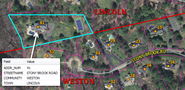
Addresses in Your City/Town, Street in an Adjacent City/Town
TOWN and COMMUNITY values in the ADQT_ADDRESS_POINT product will disagree where an address point is located in the queried town but its street is geographically within an adjacent town. An example of this is 41 Stony Brook Road in Lincoln (image below). 41 Stony Brook Road will have a COMMUNITY value of "WESTON" because the street that provides access to that address is within Weston. But it will also have a TOWN value of "LINCOLN" because the address (the point) is geographically in Lincoln.
Village Names
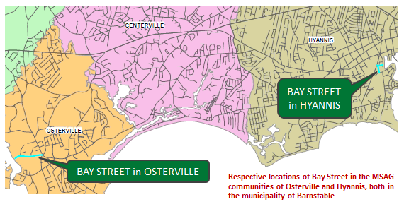
Village name is another value that is sometimes appended to the Street Name and Address fields. Because the MSAG was one of the primary sources used in the creation of the streets database, MSAG Community values are available and are sometimes necessary to keep addresses unique. Cities and towns that have these MSAG Communities are Barnstable, Boston, Deerfield, Dennis, Nantucket, Northampton, Palmer, Springfield, and the three towns (Ayer, Harvard and Shirley) in which Fort Devens is located. MSAG Community values do not represent a comprehensive listing of the villages for that city or town. Because their sole function was to keep street names unique, they were only created where there was ambiguity in regards to duplicate streets. So, some villages will not be represented in the names appended to streets in the MADQT_ADDRESS_POINT product. For example, the village name Allston is not an MSAG Community name in Boston; Allston addresses are lumped in with Brighton, which is an MSAG Community. Another example of this is the village of East Dennis, which is not an MSAG Community in Dennis.
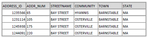
In Barnstable, there are two Bay Streets, one in the village of Hyannis and the other in Osterville. Both of these village names are MSAG Communities in Barnstable and are shown in this example from the Basic Address Points attribute table:
Neighborhood Names Used to Differentiate Duplicate Streets
In the vast majority of cases, the combination of address number, street name and community values keep an address unique. There are, however, a few cases where this is not true. To resolve these issues, MassGIS has added a Neighborhood value to keep the addresses distinct. An example where the neighborhood value is appended is Elm Avenue in Bourne.
There are two Elm Avenues in Bourne that are many miles apart and have overlapping address ranges; the two Elm Avenues are in pale blue in the images below.
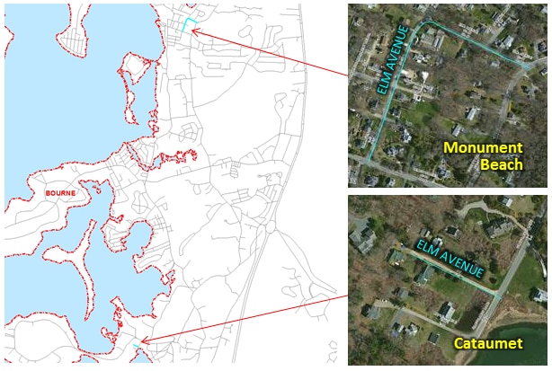
In order to keep the addresses distinct, neighborhood values of Cataumet and Monument Beach were appended. Neighborhood values are determined from USGS topological maps or local sources.
Reporting Errors and Omissions
Address assignment is a responsibility of municipal government. MassGIS cannot update the MAD unless the update comes from an appropriate municipal source. If users have address information that is not included in this product or they see errors in the data, they should contact the department in the relevant municipality responsible for tracking official addresses and for distributing address updates. Refer to a List of Address Authority Departments in each city and town for how to contact individual municipalities. If the address error or omission is confirmed by the municipality, the community’s addressing authority should notify MassGIS. Updates from municipalities are incorporated into the MAD and will appear in future address file downloads. All municipalities have been contacted concerning how to notify MassGIS of new or changed addresses as part of ensuring all their addresses are included in the NextGeneration 911 system. If the addressing authority is not familiar with how to notify MassGIS of new addresses or address errors, they can ask MassGIS.
Maintenance
MassGIS is actively updating these data and the downloadable files are refreshed weekly.