Downloads
Overview
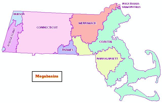
This layer represents the eight mega-drainage basins for Massachusetts, aggregated from the Major Basins layer. The delineations were based on the level 2 (4-digit) Hydrologic Unit Codes (HUCs) from the U.S. Geological Survey. Included are delineation of the Narragansett and Thames mega-basins.
The HUC is a hierarchical, numeric code that uniquely identifies hydrologic units. Hydrologic units are subdivisions of watersheds nested from largest to smallest areas and are used to organize hydrologic data. In the 4-digit HUCs, the first two digits identify the region and the first four digits identify subregions.
The polygon layer is named MEGABASINS_POLY and the line layer MEGABASINS_ARC. Annotation is included in MEGABASINS_ANNO_BASIN.
Attributes
he polygon attribute table has the following items:
| ITEM NAME | DESCRIPTION |
|---|---|
| BASIN_ID | 4-digit HUC |
| NAME | Mega basin name (for informal use only - does not conform to USGS naming) |
The mega basins' ID and names are as follows:
| BASIN_ID | NAME |
|---|---|
| 0106 | PISCATAQUA-SALMON FALLS |
| 0107 | MERRIMACK |
| 0108 | CONNECTICUT |
| 0109 | COASTAL |
| 0109 | NARRAGANSETT |
| 0110 | HOUSATONIC |
| 0110 | THAMES |
| 0202 | HUDSON |
In the arc attribute table, the item OUTLINE is coded as follows:
| ITEM NAME | DESCRIPTION |
|---|---|
| OUTLINE | Line type: 0 - Internal megabasin boundary 1 - State outline |
Maintenance
MassGIS maintains the layer, although no updates are planned.
For other watershed data, see these layers:
- Major Watersheds (similar to 8-digit HUCs)
- Major Drainage Basins (similar to 8-digit HUCs)
- Drainage Sub-basins (more delineated than the 12-digit HUCs)
- NRCS HUC (8, 10, 12) Basins (8-, 10-, and 12-digit HUC delineations)