Downloads
Overview

MassGIS distributes two feature classes created by the USFWS National Wetlands Inventory program:
- Wetland polygons (NWI_POLY) - These data delineate the areal extent of wetlands and surface waters as defined by Cowardin et al. (1979).
- NWI Project Metadata (NWI_POLY_METADATA) - This data set represents the extent, status, and location of mapping projects for NWI Version 2, Surface Waters and Wetlands. Each project polygon contains information on the type and date, scales and emulsion of imagery used to map the wetlands within specific project boundaries, and a link to a document about specific mapping techniques and habitat information for that project. The NWI_POLY layer should be used in conjunction with this layer.
The NWI project was established to generate information about the characteristics, extent and status of the Nation's wetlands and deepwater habitats. This information is used by Federal, State, and local agencies, academic institutions, U.S. Congress, and the private sector. The Emergency Wetlands Resources Act of 1986 directs the Service to map the wetlands of the United States. The Act also requires the Service to produce a digital wetlands database for the United States.
Visit the National Wetlands Inventory website for more details.
Production
MassGIS downloaded the data for Massachusetts (dated 2025-05-07) from the US Fish and Wildlife Service Seamless Data by State page on September 11, 2025 and projected it to the Mass. State Plane Meters NAD 1983 Mainland coordinate system.
The National Wetlands Inventory - Version 2, Surface Waters and Wetlands Inventory was derived by retaining the wetland and deepwater polygons that compose the NWI digital wetlands spatial data layer. Then reintroducing any linear wetland or surface water features that were orphaned from the original NWI hard copy maps by converting them to narrow polygonal features. Additionally, the data are supplemented with hydrography data, buffered to become polygonal features. They act as a secondary source for any single-line stream features not mapped by the NWI and to complete segmented connections.
Wetlands for most projects mapped after 2015 were mapped to include all surface water features and are not derived data. The linear hydrography dataset used to derive Version 2 was the U.S. Geological Survey's National Hydrography Dataset (NHD). Specific information on the NHD version used to derive Version 2 and where Version 2 was mapped can be found in the COMMENTS field of the NWI Project Metadata feature class.
Certain wetland habitats are excluded from the National mapping program because of the limitations of aerial imagery as the primary data source used to detect wetlands. These habitats include seagrasses or submerged aquatic vegetation that are found in the intertidal and subtidal zones of estuaries and near shore coastal waters. These habitats, because of their depth, go undetected by aerial imagery. By policy, the Service also excludes certain types of "farmed wetlands". These may be defined by the Food Security Act or that do not coincide with the Cowardin et al. definition. Contact the Service's Regional Wetland Coordinator for additional information on what types of farmed wetlands are included on wetland maps.
Attributes
The polygon layer NWI_POLY contains the following fields:
| Field Name | Description |
|---|---|
| ATTRIBUTE | Alphanumeric code identifying the wetland classification of the polygon. The wetland classification codes are a series of letter and number codes that have been developed to adapt the national wetland classification system to map form. These alpha-numeric codes correspond to the classification nomenclature (Cowardin et al. 1979) that best describes the habitat. (for example, PFO1A). Currently there are over 7,000 code combinations in the dataset with over 14 million possible permutations of the code. See information on the wetland codes |
| WET_TYPE | General description of the wetland based on the Cowardin wetland classification. Renamed by MassGIS from WETLAND_TYPE. The first two or three characters of the ATTRIBUTE are listed in parentheses. See type names and descriptions below. Estuarine and Marine Deepwater - Open water estuary, bay, sound, open ocean. Estuarine and Marine subtidal water (E1, M1). Estuarine and Marine Wetland - Vegetated and non-vegetated brackish and saltwater marsh, shrubs, beach, bar, shoal or flat. Estuarine intertidal and Marine intertidal wetland (E2, M2). Freshwater Emergent Wetland - Herbaceous marsh, fen, swale and wet meadow. Palustrine emergent (PEM). Freshwater Forested/Shrub Wetland - Forested swamp or wetland shrub bog or wetland. Palustrine forested and/or Palustrine shrub (PFO, PSS). Freshwater Pond - Pond. Palustrine unconsolidated bottom, Palustrine aquatic bed (PUB, PAB). Lake - Lake or reservoir basin. Lacustrine wetland and deepwater (L). Riverine - River or stream channel. Riverine wetland and deepwater (R). Other - Farmed wetland, saline seep and other miscellaneous wetland. Palustrine wetland (Misc. types, PUS, Pf). |
| ACRES | Area of the polygon in acres, recalculated by MassGIS after projection to Mass. State Plane Mainland Meters NAD 1983 Mainland using ESRI's geometry calculator in ArcMap 10.8.1. |
The polygon layer NWI_POLY_METADATA contains the following fields:
| Field Name | Description |
|---|---|
| PROJECT_NAME | Name of the wetland mapping project |
| STATUS | Current status of the project: Completed - The project is completed and on the Wetlands Mapper for public viewing No_Data - This project/area represents an area where no wetlands mapping has been conducted |
| SUPPMAPINFO | URL to the Supplemental Map Information document related to this project area |
| DATA_SOURCE | Source of the data (what organization created the wetlands data) |
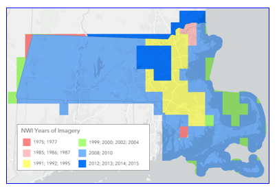
| IMAGE_YR | Year of the most recent imagery used for wetland delineation |
| IMAGE_DATE | Month and year of all imagery used for wetland delineation |
| IMAGE_SCALE | The best image scale used for wetland delineation represented by RF scale value or a generalization of ground resolution, 0 = unknown, 1 = < or equal to 1 meter but greater than 0, 2 = < or equal to 2 meters but greater than 1 meter, 3 = < or equal to 3 meters but greater than 2 meters. |
| ALL_SCALES | All the image scales or resolutions of the imagery used for delineating the wetlands |
| EMULSION | Emulsion type of the imagery used in delineation (similar to SOURCE_TYPE) |
| COMMENTS | Specific comments to be shared with the public |
| SOURCE_TYPE | Identifies the source of data used for creation of the wetland polygon data. Scalable - Data created from various sources see the Supplemental Map Information document for specifics. CIR - Color Infrared imagery BW - Black and White imagery TC - True Color imagery |
Disclaimer
Digital wetlands data are intended for use with base maps and digital aerial photography at a scale of 1:12,000 or smaller (zoomed out). Due to the scale, the primary intended use is for regional and watershed data display and analysis, rather than specific project data analysis. The map products were neither designed nor intended to represent legal or regulatory products. Questions or comments regarding the interpretation or classification of wetlands or deepwater habitats can be addressed by visiting the NWI web page. Due to the quantity and complexity of the wetlands data the wetlands only display at 1:250,000 scale and greater (zoomed in).
These data were developed in conjunction with the publication Cowardin, L.M., V. Carter, F.C. Golet, and E.T. LaRoe. 1979. Classification of Wetlands and Deepwater Habitats of the United States. U.S. Department of the Interior, Fish and Wildlife Service, Washington, DC. FWS/OBS-79/31. Alpha-numeric map codes have been developed to correspond to the wetland and deepwater classifications described. For more information on the wetland classification codes visit http://www.fws.gov/wetlands/Data/Wetland-Codes.html. The U.S. Fish and Wildlife Service uses data standards to increase the quality and compatibility of its data. The standards used for the wetlands includes the FGDC Wetlands Mapping Standard, FGDC-STD-015-2009.
Note that coastline delineations were drawn to follow the extent of wetland or deepwater features as described by this project. They may not match the coastline shown in other base maps.
Maintenance
MassGIS provides these data for use with other data in Mass. State Plane projection and does not maintain or update the database. Data not currently in digital format will be added to database when made available by NWI.
The November 2020 update replaced all previous versions of these layers. The polyline layer NWI_ARC was discontinued at this time as it was no longer maintained by USFWS.
For more wetlands data, see the MassDEP Wetlands and MassDEP Hydrography (1:25,000).
| Last updated: | September 23, 2025 |
|---|