Downloads
Overview
The MassDEP Wetlands (2005) dataset comprises two feature classes:
- The WETLANDSDEP_POLY layer contains polygon features delineating mapped wetland resources and attribute codes indicating wetland type.
- The WETLANDSDEP_ARC layer was generated from the polygon features and contains arc attribute coding based on the adjacent polygons as well as arcs defined as hydrologic connections.
Together these statewide layers enhance and replace the original MassDEP wetlands layers, formerly known as DEP Wetlands (1:12,000). That original MassDEP wetlands layer is still available for reference.
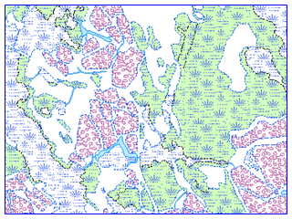
The 2005 MassDEP Wetlands layers provide a medium-scale representation of wetland areas of the state. Wetland areas consist of open water, vegetated wetlands, and coastal landforms. The hydrologic connection arcs provide a medium scale representation of linear features (less than 50 feet wide) that appear to contain flowing water (either intermittently or perennially) and flow into, out of, or between mapped wetland polygons. Hydrologic connections may consist of rivers, streams, ditches, culverts, swales, or other water conveyance features.
The wetlands and hydrologic connection information is for planning purposes only. The wetlands boundaries shown in these map layers have been determined by photographic interpretation. They do not represent, and should not be used as, wetlands delineations under the Massachusetts Wetlands Protection Act (M.G.L. c. 131 §40) and its regulations. Wetlands boundary determination for other purposes, such as the Wetlands Protection Act MA Act M.G.L. c. 131 or local bylaws must use the relevant procedures and criteria.
Production
The original MassDEP wetlands mapping project was based on the photo-interpretation of 1:12,000 stereo color-infrared (CIR) photography, captured between 1990 and 2000, and included field verification by the MassDEP Wetlands Conservancy Program (WCP). In 2007 the MassDEP WCP began a statewide effort to assess and, where necessary, update the original wetlands data. The MassDEP WCP used ESRI ArcGIS Desktop software, assisted by the PurVIEW Stereo Viewing extension, to evaluate and update the original wetlands features based on photo-interpretation of 0.5m (1:5,000) digital stereo CIR imagery statewide, captured in April 2005. No field verification was conducted on this updated 2005 wetlands data.
The 2005 WETLANDSDEP_POLY layer includes polygon features that distinguish it from its predecessor by overall changes in size and shape. In addition, new polygons have been created and original ones deleted. Many of the polygons, however, remain the same as in the original layer. All changes have been made according to the techniques described below. For the purpose of cartographic continuity, a small number of coastal polygons outside the state boundary were added based on data provided by the United States Geological Survey (USGS) and the National Oceanic and Atmospheric Administration (NOAA).
The 2005 WETLANDSDEP_ARC layer was generated to support map display and was designed to cartographically enhance the rendering of wetland features on a base map. Arc features in this layer were generated from the wetland polygons and coding (ARC_CODE) was assigned based on the adjacent polygon types. Hydrologic connection features (ARC_CODE = 7) were then added. Where delineated, these arc features indicate an observed hydrologic connection to or between wetland polygons. Although efforts were made to be comprehensive and thorough in mapping hydrologic connections, due to the limitations of aerial photo-interpretation some areas may have been missed.
The types of updates made to the original wetland features include alteration, movement/realignment and reclassification. In some cases original wetland areas have been deleted and new areas have been added. Updates to original wetland features resulted from the following factors: changes in the natural environment due to human activity or natural causes; advances in the field of remote sensing, allowing for more refined mapping.
Edits to the original wetland data include:
- Addition of new wetland and hydrologic connection features
- Appending (expansion or realignment) of existing (original) wetland and hydrologic connection features
- Reclassification of wetlands features, due to change in wetlands environment from the original classification
- Movement (or shifting) of original wetland features to better match the source imagery
- Deletion of original wetland or hydrologic connection features due to changes in wetlands environment or inconsistency with mapping criteria. Features that are inconsistent with the mapping criteria include isolated wetlands that are are less than ¼ acre in size and hydrologic features that do not connect to wetland polygons.
Please note that although efforts were made to be comprehensive and thorough in the evaluation and mapping of statewide wetland resources some areas of the state may have been missed. Many of the wetland and hydrologic connection features remain the same as in the original data. The polygon attribute SOURCE_SCALE may be used to identify areas that have been altered from the original wetlands.
- SOURCE_SCALE code 5000 indicates an updated wetland area.
- SOURCE_SCALE code 12000 indicates an unaltered, original wetland polygon.
Attributes
Wetlands Polygons
The WETLANDSDEP_POLY attribute table contains these fields:
| Field Name | Type (Width) | Description |
|---|---|---|
| WETCODE | LONG INT | WETLAND CONSERVANCY PROGRAM TYPE CODE |
| IT_VALC | TEXT (16) | WETLAND CONSERVANCY PROGRAM TYPE ABBREVIATION |
| IT_VALDESC | TEXT (60) | WETLAND CONSERVANCY PROGRAM TYPE DESCRIPTION |
| POLY_CODE | LONG INT | SIMPLIFIED POLY CODE ADAPTED FROM 1:25,000 HYDROGRAPHY |
| SOURCE | TEXT (12) | ORIGINATOR OF FEATURE |
| SOURCE_SCALE | LONG INT | RELATIVE SCALE OF THE BASE IMAGE USED TO DELINEATE THE FEATURE |
| AREAACRES | DOUBLE | AREA OF THE FEATURE IN ACRES |
| AREASQMI | DOUBLE | AREA OF THE FEATURE IN SQUARE MILES |
The following types of wetland features are represented in the WETLANDSDEP_POLY layer:
| WETCODE | IT_VALC | IT_VALDESC |
|---|---|---|
| 1 | BA | COASTAL BANK BLUFF OR SEA CLIFF |
| 2 | BB | BARRIER BEACH SYSTEM |
| 3 | BE | COASTAL BEACH |
| 4 | BG | BOG |
| 5 | CB | CRANBERRY BOG |
| 6 | D | COASTAL DUNE |
| 7 | DM | DEEP MARSH |
| 8 | M | SHALLOW MARSH, MEADOW, OR FEN |
| 9 | OW | OPEN WATER |
| 10 | RS | ROCKY INTERTIDAL SHORE |
| 11 | SM | SALT MARSH |
| 12 | SS | SHRUB SWAMP |
| 13 | TF | TIDAL FLAT |
| 14 | WS1 | WOODED SWAMP DECIDUOUS |
| 15 | WS2 | WOODED SWAMP CONIFEROUS |
| 16 | WS3 | WOODED SWAMP MIXED TREES |
| 17 | BB-BE | BARRIER BEACH-COASTAL BEACH |
| 18 | BB-BG | BARRIER BEACH-BOG |
| 19 | BB-D | BARRIER BEACH-COASTAL DUNE |
| 20 | BB-DM | BARRIER BEACH-DEEP MARSH |
| 21 | BB-M | BARRIER BEACH-MARSH |
| 22 | B-OW | BARRIER BEACH-OPEN WATER |
| 23 | BB-SS | BARRIER BEACH-SHRUB SWAMP |
| 24 | BB-WS1 | BARRIER BEACH-WOODED SWAMP DECIDUOUS |
| 25 | BB-WS2 | BARRIER BEACH-WOODED SWAMP CONIFEROUS |
| 26 | BB-WS3 | BARRIER BEACH-WOODED SWAMP MIXED TREES |
| 27 | BB-SM | BARRIER BEACH-SALT MARSH |
| 88 | N/A | NOT INTERPRETED |
The codes for the POLY_CODE field in WETLANDSDEP_POLY are:
| POLY_CODE | WETCODE(s) | Description |
|---|---|---|
| 1 | 9.22 | OPEN WATER PUBLIC WATER SUPPLY RESERVOIR |
| 2 | 4,7,8,20,21 | MARSH |
| 3 | 12,14,15,16,23,24,25,26 | WOODED SWAMP |
| 4 | 5 | CRANBERRY BOG |
| 5 | 11,27 | SALT MARSH |
| 6 | 9,22 | OPEN WATER FRESH |
| 7 | 10,13 | TIDAL FLAT/ROCKY SHORE |
| 8 | 1,2,3,6,17,18,19 | BEACH/DUNES |
| 9 | 9 | OPEN WATER TIDAL, BRACKISH, SALT POND |
| 10 | 9 | OPEN WATER OCEAN |
| 88 | 88 | NOT INTERPRETED |
Linear Features
The WETLANDSDEP_ARC attribute table contains these fields:
| Field Name | Type (Width) | Description |
|---|---|---|
| ARC_CODE | SHORT INT | SIMPLIFIED ARC CODE ADAPTED FROM 1:25,000 HYDROGRAPHY |
| ARC_CODE_DESC | TEXT (50) | ARC_CODE DESCRIPTION |
The codes for the ARC_CODE field in WETLANDSDEP_ARC are:
| ARC_CODE | Description |
|---|---|
| 1 | SHORELINE |
| 2 | CLOSURE LINE |
| 3 | APPARENT WETLAND LIMIT |
| 7 | HYDROLOGIC CONNECTION |
| 8 | MEAN LOW WATER LINE |
| 88 | EDGE OF INTERPRETED AREA |
NOTE: A closure line is defined as a boundary between similar, but different types of wetland resource areas. As an example, polygons with a POLY_CODE of 2 (marsh) or 3 (wooded swamp) are considered to be similar wetland resource types so the lines between these features are coded as closure lines and not as a wetland limit.
Maintenance
The MassDEP Wetlands data were developed by the MassDEP Wetland Program. For questions please contact the MassDEP Wetlands Program at email: DEP.Wetlands@mass.gov.