Executive Summary
Over the past twenty years, geospatial information has become pervasive in government, business, and in private lives. The Commonwealth of Massachusetts has created, used, and shared geospatial information for almost forty years. In that time, geospatial information grew from special data formats and services created and managed by GIS specialists to location data that is created and used in many everyday activities. Massachusetts state and local governments build and maintain large bodies of geospatial data and provide data services, such as web map applications, based upon those data. Within state government, the visions laid out in a 2007 strategic plan, a 2010 task force, and a 2011 business plan have largely been achieved. Geospatial technology has since advanced over time. The expectations of the public, industry, and government itself about geospatial data and services have changed too. The Massachusetts Geospatial Strategy describes how the Commonwealth of Massachusetts can meet these expectations, both today and over the next 5 to 10 years.
The strategy has three goals. The first goal is formalizing the state-level coordination of geospatial policy through the Massachusetts Geospatial Information Coordinating Council (MaGICC). MaGICC is to be composed of stakeholders throughout the state from within and outside of government. MassGIS – the state’s lead office for geospatial data and services – works closely with MaGICC to do the actual work entailed. The second goal is to focus on continuing to improve the most valuable statewide datasets through data governance policies, data standards, and alignment with national initiatives. The third goal is to use the coordination of MaGICC, the work of standards and policies, and the coalition-building that occurs in the two other goals to create coordinated, standards-based communities of data creators, maintainers, users, and analysts for authoritative data. The ultimate outcome of these three goals is that the Commonwealth has a way to keep authoritative data refreshed, build new kinds of data, and use geospatial data in innovative analyses and solutions: a geospatial ecosystem.
The geospatial ecosystem becomes self-sustaining, adapting over time to new kinds of data, new needs for information, and new analytical requirements. It enables governments, citizens, businesses, and society to use geospatial information efficiently. Whether that use is individual, administrative, corporate, scientific, or advocacy, the Commonwealth helps everyone equitably.
The Massachusetts Geospatial Strategy includes tactical objectives for each goal. Objectives take the form of recommended actions. The Strategy contains proposed deliverables and milestones by which these objectives are staged to achieve all the goals and the Strategy’s vision.
Introduction
The Massachusetts Geospatial Strategy is a plan to improve how users of geospatial data in the Commonwealth can achieve their missions through the Commonwealth providing geospatial data, services, support, and coordination to geospatial stakeholders in Massachusetts. Because geospatial data and services are widely used in almost every aspect of contemporary life, stakeholders comprise many entities and groups: state agencies; regional planning agencies; municipalities; federal agencies, institutions of higher education; commercial, advocacy, and non-governmental organizations; and the residents of Massachusetts. Together, the goals defined in this plan offer a sustainable and improved geospatial ecosystem for stakeholders across the Commonwealth.
Strategic Vision
The vision for the Massachusetts Geospatial Strategy is as follows:
Massachusetts’ governments, educational institutions, organizations, industries, and the public will continually have access to high-quality, authoritative, statewide geospatial data and the geospatial infrastructure to make use of these data. These data support consistent delivery of government services across the Commonwealth and make it easier to do business in Massachusetts.
Strategic Planning Research
The Massachusetts Geospatial Strategy is based upon information collected from geospatial stakeholders, MassGIS, and executive leadership in Massachusetts. An online survey was circulated widely, with 523 responses collected. Six workshops were held across the state. Discussions with MassGIS staff helped elucidate history, current actions, and plans within that office. Review of earlier planning and reference documents from MassGIS, as well as current summaries of activities and usage of resources provided an understanding of how the office has grown and the many things it does today.
The information gathered in the online survey, workshops, and in discussions with MassGIS staff and other professionals was examined using Strengths, Weaknesses, Opportunities, and Threats (SWOT) analysis.
In general, stakeholders indicated a high degree of satisfaction with MassGIS’ current services and data, and the general state of geospatial data activities in the Commonwealth. For instance, most survey respondents were happy with the online services that MassGIS provides. Although users want more kinds of data, they are content with the quality of the data available to them today.
Points of weakness found during information gathering center around communication, collaboration, and partnerships. Dataset timeliness and spatial extent are also described by some stakeholders as areas where statewide geospatial products can be improved. Specific weaknesses include the following:
- Stakeholders are eager for more community-building, partnerships, and support. These are opportunities that the geospatial strategy seeks to realize.
- Stakeholders throughout the Commonwealth are eager for more data and better mechanisms to maintain and share authoritative data. These are specific opportunities for MassGIS and the Massachusetts Geospatial Information Coordinating Council (MaGICC).
In the context of the SWOT analysis, threats might prevent the strategic goals from being implemented or achievable. Furthermore, threats could prevent successful collaboration by MaGICC or MassGIS, forestalling the advance of geospatial maturity in the Commonwealth. Therefore, the SWOT analysis threats are repeated here to contextualize how the goals and recommendations avoid them:
- Efforts to establish policies, standards, and mechanisms to govern statewide geospatial data will fail without a designated authority.
- Establishing a geospatial council without authority to fund priorities or compel action would severely constrain its effectiveness.
- Poorly defined roles and responsibilities for MaGICC and MassGIS will impede the implementation of plan goals.
- If MaGICC is perceived as being ineffective, the geospatial community will not subscribe to actions, ideas, or initiatives the Council develops.
- If MassGIS lacks sufficient funding, many of the ideas presented in this strategic plan would be difficult to implement.
Major Components of the Strategy
MassGIS
The Bureau of Geographic Information (Commonwealth of Massachusetts, Executive Office of Technology and Security Services), more commonly known as MassGIS, is an important factor in this plan. MassGIS grew from the former Executive Office of Environmental Affairs consolidating GIS across agencies in 1988. Eleven years later, the State Legislature created and moved MassGIS to the Office of Geographic and Environmental Information in the Executive Office of Energy and Environmental Affairs. Over the years, the name MassGIS became the most common shorthand for the office. In 2007, Massachusetts was awarded a United States Geological Survey 50 States Initiative grant to prepare a statewide strategic plan. This plan, A Strategic Plan for Massachusetts’ Spatial Data Infrastructure, was prepared by Applied Geographics, Inc. for MassGIS and the Massachusetts Geographic Information Council Strategic Plan Steering Committee. In 2009, realizing that MassGIS was outgrowing its then-current home office, a task force was convened to study where MassGIS should be housed in Commonwealth government. The Sustaining MassGIS for the Future: Organization, Funding, and Governance Recommendations Report of the MassGIS Task Force resulted in legislation that moved MassGIS to the Executive Office of Technology and Security Services (EOTSS). The legislation stated MassGIS’ role in state government and the state’s economy:
Section 5. There shall be a bureau of geographic information within the office which shall develop, maintain, update and distribute geographic information, technology, data and services for use by state agencies, municipalities and the public. The office shall coordinate all geographic information activities in state and local government and shall collect, manage and distribute geographic information maintained by state agencies and local government agencies. Subject to sufficient appropriation, the office shall provide technical services related to geographic information to state agencies and municipalities. The secretary may, as needed, set standards for the acquisition, management and reporting of geographical information and for the acquisition, creation or use of applications employing such information by any state agency and the reporting of such information by municipalities. (General Laws, Part I, Title II, Chapter 7D)
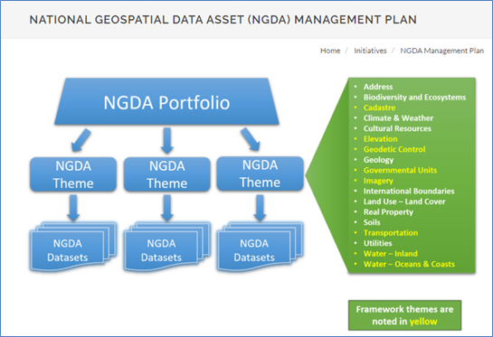
Today, MassGIS provides a wealth of data, services, and coordinating activities to all stakeholders. These include publishing authoritative data through the Massachusetts Data Hub as datasets, interactive maps, charts, common GIS data service formats, and application programming interfaces (APIs). Another important purview of MassGIS is the Massachusetts Spatial Data Infrastructure (MSDI). The MSDI, like its national counterpart the National Spatial Data Infrastructure (NSDI), consists of both geospatial data themes that are framework data (i.e., not derived from other geospatial data) and other authoritative data, as well as the technology, policies, standards, and people necessary to enable geospatial data management and sharing across the public and private sector. The intent of the NSDI, and its expansion into a portfolio of National Geospatial Data Assets (NGDA), is to have nationally consistent, authoritative, and useful geospatial data readily available for the nation (Figure 1). The MSDI is an analogous concept at the state level.
Figure 1. National Geospatial Data Assets portfolio, themes, and relationship to datasets (NGDA Management Plan)
Depending on the theme, authoritative data themes and individual datasets within them may not extend over the entire geography of Massachusetts. For example, coastal datasets are confined to just part of the state. Nonetheless, Massachusetts currently publishes eleven categories of data:
- Census and Demographics
- Coastal and Marine
- Conservation and Recreation
- Cultural Resources
- Environmental Modeling
- Image Data (aerial imagery, lidar)
- Infrastructure and Built Environment (including transportation)
- Map Indexes
- Physical Resources
- Political and Administrative Boundaries
- Regulated Areas
These categories contain many datasets (over 1100) in different formats. Not all datasets are part of the MSDI / NGDA basic authoritative themes. Furthermore, MassGIS does not create or maintain most of these datasets. However, MassGIS does ensure their publication and availability to the public. MassGIS coordinates and publishes MSDI and other authoritative themes through the MassMapper interactive map application, the Massachusetts Data Hub, and in other links and resources available on the internet. In short, the MSDI is coordinated by MassGIS, but MassGIS is not the steward or source of all themes, nor is MassGIS’ work limited to only MSDI themes.
In the last few years, MassGIS has begun to expand its focus to include support for organizations in using the vast array of geospatial data that has been gathered and curated. This expanded focus has involved application development for a variety of external organizations. And it has recently included work with the EOTSS Enterprise Analytics initiative to make use of geospatial data and technology to help address issues that cut across the traditional organizational boundaries of government agencies, requiring enterprise solutions that bring data together from many diverse sources.
MaGICC
Another entity critical to this strategic plan is the Massachusetts Geospatial Information Coordinating Council (MaGICC). While MaGICC has not yet been formed, its draft charter contains the following mission statement:
The Massachusetts Geospatial Information Coordinating Council (MaGICC) provides statewide governance for sharing, coordinating, and managing Massachusetts spatial data infrastructure (MSDI) among public bodies and the residents of Massachusetts. The MSDI includes geospatial data and the technology, staff, policies, standards, and procedures necessary to share and manage that data. The Council is located within the Executive Office of Technology Services & Security for organizational, budgetary, and administrative purposes.
The proposed MaGICC composition includes representatives from state, regional, local and federal government organizations, the private sector, higher education institutions, and non-profit organizations. As chartered, MaGICC will take a very active role in coordinating and making recommendations concerning geospatial information and services, both generally and the MSDI specifically. It will also recommend policies about geospatial information, e.g., data governance. With representatives from such a wide swath of stakeholders, MaGICC will be well positioned to participate and help guide efforts to make use of geospatial data for the Commonwealth’s Enterprise Analytics Program, through planning and operations.
It is noteworthy that MassGIS, the MSDI, and some form of coordinating council have been important parts of the state’s geospatial strategy since at least 2010. In 2009, the MassGIS Task Force report noted the need for a state geospatial coordinating organization, funding, and governance models for MassGIS. The report describes three roles of MassGIS:
- Serve as a strategic resource by:
- Supporting use of geospatial information and analysis for developing policy
- Setting investment priorities for geospatial information
- Defining standards
- Coordinating state, municipal, and federal geospatial efforts
- Serve as a technical resource, supporting:
- GIS users in all levels of government and all sectors including private sector, public, higher education, and non-governmental organizations
- Developing GIS applications and methods
- Serve as an operations office:
- Collecting and storing spatial data and assets
- Providing access to spatial data
- Provide the core data storehouse and application platform for the MASS SDI
- Coordinating maintenance of the MASS SDI
The 2009 MassGIS Task Force sought the “option that best supports a set of key goals that includes making MassGIS financially sustainable, promoting MassGIS as a Commonwealth-wide shared service, promulgating and enforcing standards, and facilitating collaboration across multiple state, regional, local and federal agencies entities [sic].” This strategic plan builds upon the tremendous progress in GIS by all stakeholders made since 2010, bringing the goals of that time up to date, but also recognizing that those goals are still both valid and important as part of the Massachusetts Geospatial Strategy.
Overview of the Geospatial Strategy
The geospatial strategy has three goals: having MaGICC assist in the coordination of geospatial activities across the state; leveraging MassGIS as a technical resource to advance MaGICC initiatives directly and indirectly; and building a professional-technical ecosystem of data creators, consumers, and data supply chains that provide the greatest value of GIS to the state’s stakeholders. The relationship between these goals, and how they create a coherent geospatial strategy is described here; details of each goal are presented in subsequent sections.
In this strategy, MaGICC serves as a coordinating and guiding body, ensuring that all stakeholders – within and outside of government – have a voice in the Commonwealth’s geospatial information policies, services, data development, and publication. Recognizing that coordination, collaboration, sound policy, and shared technologies and resources can eliminate wasteful redundancy and benefit all, it is critical that the state establish a collaborative governance body. Geospatial data is often created by many parties, aggregated into authoritative data and services, and then used by many other parties. This is often called the “value chain of information”. Creating strong value chains requires an understanding of information sources, use cases, and the technical skills required to forge the information to serve the use cases.
MassGIS is an essential part of the strategy. MassGIS is a powerhouse of operational capabilities and technical resources. MassGIS already populates (directly or through coordination) many of the key data themes in the Massachusetts Spatial Data Infrastructure, provides extensive technical support for government at all levels, and develops, maintains, and improves a powerful suite of public facing web services and applications. In particular, MassGIS is the primary geospatial support for the State 911 program, providing a highly accurate and complete address point dataset, as well as land ownership information and boundaries, statewide aerial imagery and elevation data, and an authoritative statewide transportation network. MassGIS is frequently called upon to support other Secretariat’s programs related to land use, climate resilience, clean energy siting, social services planning and provision, housing regulations and development, and other Governor’s priorities and agency missions. Additionally, MassGIS is currently seeing a significant increase in application development requests from other Secretariats and quasi-government agencies to build tools that use the authoritative master address database developed for State 911, in combination with other data sets MassGIS aggregates from other public sector providers. This increased appetite for application development, as well as the need to improve the speed of updates for the State 911 data is driving a need to expand the MassGIS team, which will also increase the ability for MassGIS to support further collaboration across the public sector enterprise.
Together, MassGIS and MaGICC will provide a fabric of policy, process and technical resources and support for data production and use by geospatial stakeholders. This empowered geospatial tandem strategically guides the future of geospatial work in the state and helps to realize the envisioned future. Amongst other benefits, MassGIS and MaGICC collaboration furthers the creation and improvement of statewide authoritative data and services, as well as the very valuable use of geospatial information in government, commerce, and by the public. The close organizational relationship of MassGIS and MaGICC with EOTSS and their enterprise focus on analytics, project management, strategy, and data governance will serve to greatly strengthen the effectiveness of the MA Geospatial Strategy.
Relationship with Enterprise Analytics
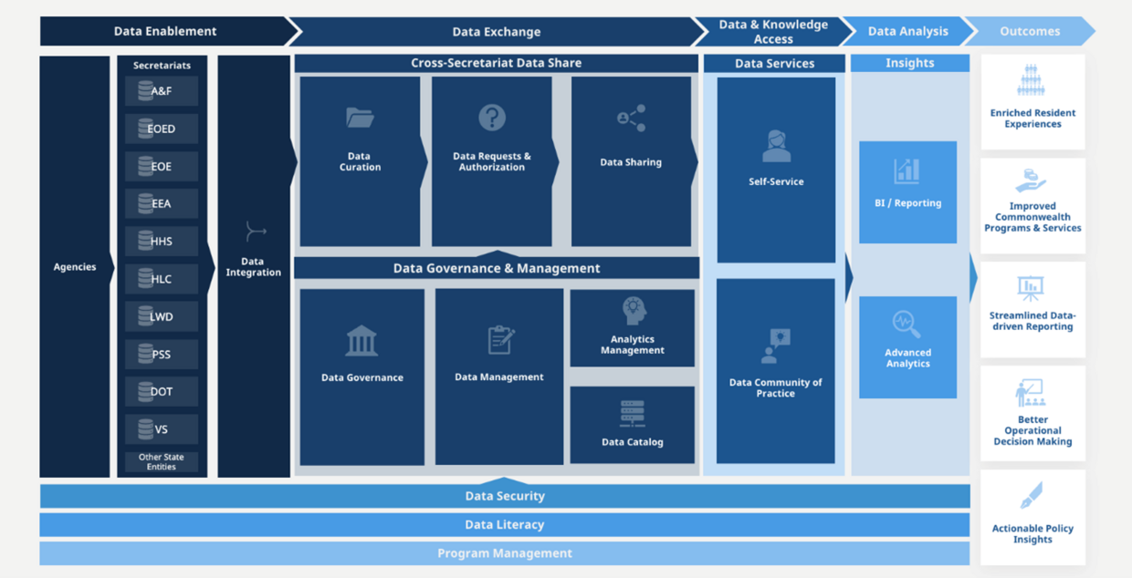
Within EOTSS, MassGIS works in close partnership with the Massachusetts Data Office, which leads the executive branch’s data strategy and facilitates data sharing across state agencies and with the public. In 2025, the Data Office launched the Enterprise Analytics program to ensure that data drives every decision, policy, and program in the Commonwealth. To realize this vision, the program is focused on modernizing, standardizing, and streamlining technologies and processes for cross-agency data sharing and analysis.
A core element of the program’s approach is tackling high impact use cases that align with current policy priorities while also strengthening long-term analytics capabilities. The Data Office is convening stakeholders around key areas such as education, sustainable development, and labor force participation—delivering immediate value to residents while laying the foundation for broader data-driven decision-making (see figure 2). Geospatial data and analysis will be critical to many of these use cases.
Similarly, the technologies and processes developed through the Enterprise Analytics program will help improve the discoverability and governance of geospatial data assets, supporting the MassGIS mission to better serve its stakeholders. Over the coming years, MassGIS and the Data Office will continue to partner closely, collaborating to advance both the Enterprise Analytics program and the Massachusetts Geospatial Strategy.
Figure 2. The Massachusetts Data Office will mature enterprise analytics capabilities over time across the Commonwealth by convening agency partners to execute on key use cases.
The strategic goals contained in the Strategy create a virtuous cycle (Figure 2), in which improvement is continuous and sustained over time. This cycle is already established: it is essentially the basis on which Massachusetts has operated following the 2009 MassGIS Task Force report, even if that report did not explicitly call this out as a strategy. Data and data services produced by this virtuous cycle will follow FAIR data principles (Findable, Accessible, Interoperable, and Reusable), because the cycle is structured to engage all stakeholders.
Programmatic Goals and Recommendations
The rest of this document outlines the strategic goals. Each goal is described in a brief sentence, with a fuller explanation of the rationale and benefits following it. Recommended objectives to achieve the goal are provided in a table after each goal. Factors to consider in pursuing the recommendations follow each table of recommendations.
Goal 1. MaGICC will provide collaborative community influence for its recommendations on the MSDI and will have a clearly defined relationship to MassGIS.
MaGICC will mobilize collaborative community influence in support of recommendations and actions that improve the Massachusetts Spatial Data Infrastructure. MassGIS will work collaboratively with MaGICC, providing the council with resources and capabilities to implement recommendations regarding the MSDI.
Rationale
During the stakeholder workshops conducted in the information gathering phase of the planning process, participants repeatedly expressed interest in objectives for which no organizing authority currently exists. The root of the challenge is a lack of authority across all stakeholders and sectors to compel action toward objectives that benefit the geospatial stakeholder ecosystem. MassGIS and EOTSS maintain that authority for state agencies, but not for the broader stakeholder community. For example, stakeholders desire more data sharing and collaborative data development, but there are few requirements for use of the same data schemas across non-executive branch government entities statewide and very little means of enforcement. Stakeholders expressed the need for coordination and collaborative development of policies and actions. MaGICC will fill that role for geospatial information and coordination across the geospatial community. Due to the inclusion of representatives from all stakeholder sectors on MaGICC, it will be possible for the Council to wield influence that may promote more collaboration and cooperation across the geospatial community. If this influence does not prove to be sufficient, it may be necessary to explore legislative remedies to generate more consistent and complete geospatial data to be developed and shared across the Commonwealth, including potentially codifying the role of a statewide Geospatial Information Officer (GIO) role within MassGIS to lead collaboration between MassGIS and MaGICC and across the state’s geospatial data and technology leadership to improve the MSDI. This role would ultimately be filled by the MassGIS Executive Director, and operate similarly to other statewide roles within EOTSS enabling statute.
To advance the MSDI, the Massachusetts geospatial ecosystem needs institutionalized mechanisms to gather stakeholders together and to allocate resources for their use. MaGICC will support and facilitate both mechanisms in coordination with MassGIS and in consultation with the state’s data leadership. While MaGICC will not have explicit enforcement authority, the fact that all affected stakeholders will be represented on the Council, that the Council will be chartered with the goals to enhance coordination and facilitate statewide development of geospatial data, and that formal relationships will be institutionalized between MassGIS, MaGICC and other state partners to agree upon standards and make or recommend policy decisions for the entire geospatial community will provide assurance to all stakeholders that they have a voice and make it much more likely that all will comply with matters agreed upon by their Council.
This collaborative approach will enable the Commonwealth to better manage its spatial data infrastructure as an enterprise resource by aligning overlapping governance efforts and data initiatives. MassGIS, in turn, will serve as the conduit between state decision-makers and the stakeholders, communicating needs up from the community, and coordinating activities and resources recommended by MaGICC. MassGIS will also serve as a partner to other state agencies, institutionalizing those relationships as needed to ensure long-term coordination of data-related activities.
Benefits
Creation of an influential coordinating council representing all sectors will facilitate the following outcomes for the Massachusetts geospatial ecosystem:
- Establishment of a collaborative governance structure to promote and facilitate actions that advance the Mass SDI
- Creation of an executive-level GIS champion to advocate for the needs of stakeholders
- Institutionalized coordination across public bodies at all levels
- Better integration of geospatial technology and services across state agencies, leading to delivery of better services to the public
- Access to better information products for business use cases across the Commonwealth, including direct support for analytical use cases across the government enterprise
- Improved coordination of activities and distribution of resources between stakeholders in government and non-government organizations
- Enhanced data sharing and reduced duplication of effort across agencies and divisions of government, leading to more efficient use of public funds
Objectives
Objectives are recommendations, at a general level, for how to achieve a strategic goal. Objectives for Goal 1 are shown in Table 1.
Table 1. Objectives associated with Goal 1.
| Objective Number and Title | Description |
|---|---|
| 1.1 Convene MaGICC | Convene MaGICC to engage a broad range of stakeholder representatives with decision-making responsibilities. |
| 1.2 MassGIS Implements MaGICC Recommendations | Use MassGIS as the implementation arm for the strategic and programmatic actions recommended by MaGICC. |
| 1.3 Establish sustainable funding for MSDI development and maintenance | Establish recurring, sustainable funding to support MSDI development and maintenance activities, in some cases providing funding to others through grants, cooperative agreements, and other funding vehicles. |
| 1.4 Formalize relationships between MaGICC, MassGIS, and state partners | Establish formal relationships, including funding agreements where appropriate, between state agencies, MaGICC and MassGIS. |
| 1.5 Empower MaGICC in pursuit of its mission to improve the MSDI | Evaluate ways to empower MaGICC to pursue its mission and support related initiatives. This evaluation will be done in collaboration with the geospatial stakeholder community, and in consultation and coordination with the State’s CIO. |
Implementation Considerations
The following dependencies, challenges, and constraints should be considered in implementing Goal 1 objectives:
- Prioritizing the establishment of MaGICC will provide the ability to begin the coordination efforts immediately
- The collaboration with the stakeholder community to evaluate ways to empower MaGICC appropriately to support pursuit of its mission can be more effectively accomplished after the Council has had a period of time to work toward developing prioritized recommendations, and establishing measures of success to better evaluate opportunities and challenges
- Identifying shared and specific funding as a vehicle for supporting critical activities necessary to improve data and the MSDI
- Implementing mechanisms for sustainable funding is likely a multi-year effort
- Institutionalizing relationships between public bodies need to be institutionalized to ensure lasting coordination and to avoid overlapping efforts
Goal 2. MaGICC will coordinate the creation of data governance policies, with stakeholder participation, for authoritative base geospatial data themes.
MaGICC will coordinate developing a geospatial data governance framework for Massachusetts, in consultation and coordination with Massachusetts’ Chief Information Officer and Chief Data Officer, to ensure that work accords with EOTSS policies, standards and guidelines. Since geography provides a natural structure for the integration of the Commonwealth’s federated data holdings within agencies, geospatial data governance will also improve the consistency of the Commonwealth’s enterprise-wide data. Agency data “islands” that cannot be brought together become a data archipelago when geography is used to link them. High-quality, consistent, geospatial data – an outcome of data governance – also allows the state to serve its citizens better through services like a single digital portal that connects an individual to every aspect of their relationship to state government, using both geography and individual identity. Enterprise data analytics are an important part of the Commonwealth’s digital strategy and analytics are more powerful when built on high-quality datasets that integrate with each other across the government enterprise. Consistent governance, policies, and standards of geospatial data themes are foundations that support the state’s highly-rated digital strategy. MaGICC will promote and incentivize stakeholder participation in the identification, governance, and analyses of authoritative data.
Rationale
Consistent, sustained data governance efforts will ensure that the MSDI is continually maintained and improved for the benefit of stakeholders across all industries and sectors. The success of the Commonwealth’s geospatial data governance will be defined by the degree of coordination and collaboration across stakeholders. For this reason, MaGICC’s reach and influence are needed to bring decision makers and stakeholders together to define governance outcomes that meet the Commonwealth’s needs in achievable ways. MaGICC’s composition of secretariat-level executives, state agency partners, and data contributors and consumers across the public, private, and non-profit sectors will allow the Council to merge a broad range of stakeholder perspectives with a network of available resources. The overall outcome will be a highly collaborative, well-resourced governance apparatus that strengthens the Commonwealth’s framework data and, in turn, contributes to the national spatial data infrastructure. A well-governed, complete and consistent set of framework data assets are essential foundational elements of an effective enterprise analytics initiative capable of providing solutions to the most complex problems faced by the Commonwealth.
Benefits
A coordinated, participatory data governance foundation will facilitate the following outcomes for the MSDI:
- Coordination of data governance across stakeholders and tiers of government will improve the discoverability, accessibility, and usability of the Commonwealth’s geospatial data, in alignment with the Commonwealth’s Enterprise Analytics program
- Use of framework data working groups will ensure that standards and implementation plans meet stakeholders’ needs and are feasible
- Framework data working groups will provide subject matter experts from public and private entities with an opportunity to participate in the development of data themes and standards
- Alignment of Massachusetts’ standards with national standards will position the Commonwealth to contribute to the national spatial data infrastructure
- MassGIS’ existing communication tools and stakeholder network, along with new ones, can be used to keep the geospatial community informed and engaged in data activities
Objectives
Objectives for this goal are shown in Table 2.
Table 2. Objectives associated with Goal 2.
| Objective Number and Title | Description |
|---|---|
| 2.1 Define geospatial data outcomes that align with state policies and priorities for data and information technology | MaGICC will coordinate geospatial data governance objectives, policies, and processes that support the statewide framework data that forms a key component of the MSDI, as well as defining key outcomes related to enterprise use and analyses of the data |
| 2.2 Establish working groups for framework data themes | As part of the governance structure, establish working groups charged with developing standards and implementation plans for MSDI framework data themes and other potential data themes. |
| 2.3 Define data standards and implementation strategies with community stakeholders | Working groups support and assist stakeholders and the geospatial community in defining data standards and policies, working under the established framework of MaGICC, and in coordination with MaGICC and MassGIS, and the MA Data Office. |
| 2.4 Align standards and governance with NSDI to support interoperability | Ensure alignment with and support for the National Spatial Data Infrastructure as part of the activities MaGICC undertakes to identify and govern statewide geospatial data. |
| 2.5 Coordinate stewardship of statewide authoritative data | MassGIS will oversee data stewardship of MSDI themes within MassGIS. MaGICC will facilitate collaboration with other organizations that have theme stewardship roles. |
| 2.6 Develop regular communication channels | Create and use a communications plan to ensure the geospatial community is kept informed of data-related updates and activities, as well as other relevant news. The plan will also define channels for communications to come from stakeholders to MaGICC and MassGIS efficiently. |
Implementation Considerations
The following dependencies, challenges, and constraints should be considered in implementing Goal 2 objectives:
- Collaborative governance is required to ensure compliance with data standards, policies, and processes
- Statutory authority may ultimately be needed to ensure compliance to establish collaborative governance standards for the non-executive branch members of the geospatial ecosystem
- Massachusetts standards should be aligned with national standards where appropriate
- Sustained participation in working groups will require dedicated resources from partners and stakeholders
- Governance outcomes should align with existing state policies and procedures for enterprise data, analytics, and technology
- Assigning data stewardship outside of MassGIS will require steward organizations to dedicate resources to manage data responsibilities
- Communication plans for MaGICC and MassGIS collaborative activities should be aligned with MassGIS’ existing communications efforts and should leverage existing channels and relationships where possible
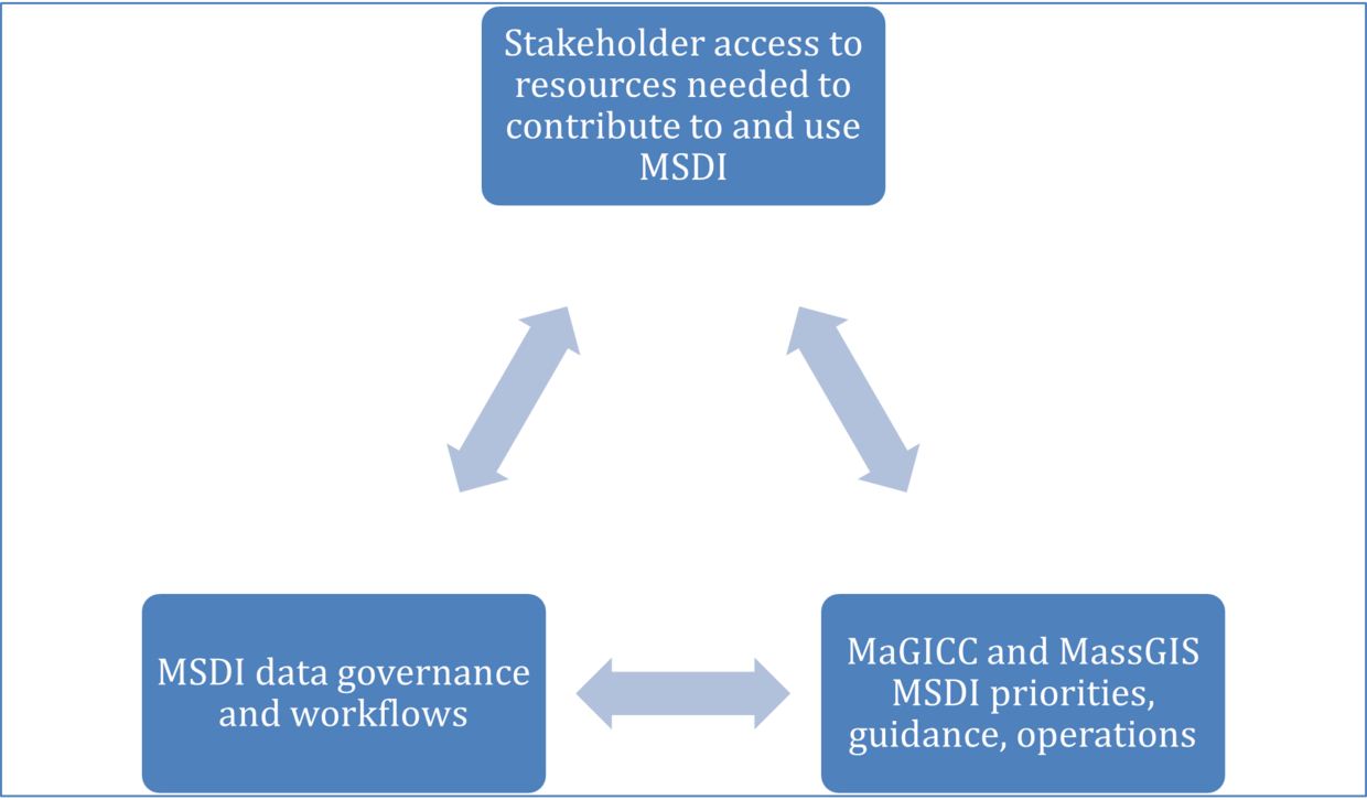
Goal 3. MaGICC and MassGIS will facilitate stakeholder access to resources needed to contribute to statewide authoritative data.
MaGICC and MassGIS will ensure that stakeholders across the state have access to resources to develop, maintain, and share authoritative data. MaGICC and MassGIS will strive to support stakeholders in building capacity to ensure that data activities are repeatable and sustainable.
Rationale
Stakeholders will need reliable access to resources and support after the collaborative governance foundation is created to ensure that they can contribute to the Commonwealth’s framework data in a sustainable manner. Across all information gathering activities during the planning process, stakeholders expressed a desire for more data-related resources including funding, technical support and guidance, and tools for sharing and updating authoritative data. MassGIS will serve as the primary architect of the resource network, working with stakeholders to assess needs, build coalitions, and direct funding and support. MassGIS will also assist with cementing sustainable data supply chains, whether existing or new, for contributors of framework data. MassGIS, with guidance from MaGICC, will help to build these channels for collaboration and support initially, and will then continue to steer resources to stakeholders as these mechanisms mature.
Benefits
A coordinated stakeholder resource network will facilitate the following outcomes for the Massachusetts geospatial ecosystem:
- Production of higher quality, more interoperable data by stakeholders
- Opportunities for cost-sharing to advance data initiatives for thematic and geographic communities of interest
- Institutionalized partnerships that are not personnel-dependent
- More opportunities for workforce development and increased geospatial literacy
- Easier methods of sharing and editing authoritative data for trusted contributors
Objectives
Table 3. Objectives associated with Goal 3.
| Objective Number and Title | Description |
|---|---|
| 3.1 Identify government agency needs & capabilities | Work with government at all levels to identify data needs and capabilities to collect, maintain, and disseminate high-quality data consistently. |
| 3.2 Seek state and other funds to support statewide authoritative data | Seek state funding, as well as other funding sources, to support statewide authoritative data development and maintenance. |
| 3.3 Build/promote regional & thematic collaborations | Build and institutionalize stakeholder collaborations across regions and communities of interest to pool resources and coordinate mutually beneficial geospatial activities. |
| 3.4 Seek funding and resources for partnerships and collaborative work | Seek collaborative funding opportunities and partnerships through MaGICC and MassGIS, including exploring license agreements. |
| 3.5 Design and help implement data supply chains | Design and implement data production pipelines and workflows (data supply chains) that create authoritative data and include data creators and editors. |
| 3.6 Coordinate activities that promote geospatial workforce development | Coordinate opportunities through MaGICC, MassGIS, and partners for workforce development and expanded geospatial literacy across the state. |
| 3.7 Host a data-sharing platform | Continue to provide a data-sharing platform operated by MassGIS for stakeholders across the state. |
Implementation Considerations
The following dependencies, challenges, and constraints should be considered in implementing the Goal 3 objectives:
- Many data governance and data development objectives, such as establishing working groups and assessing agency needs and capabilities, can be conducted concurrently because of the overlap in stakeholder participation
- Resource constraints may limit smaller entities’ degree of participation in multiple, concurrent data activities and should be mitigated
- Development of framework themes can be staggered over time to accommodate stakeholders
- Supply chain development can begin with formalizing efforts by existing data contributors before new pipelines are designed and implemented
- Consistent framework data development is highly dependent on availability of funding and other resources
- MassGIS currently provides a data sharing platform, aligned and integrated with the State’s overall data platform; this geospatial data platform should be continued as part of the broader data sharing effort by the Commonwealth
Implementing the Plan
The geospatial strategy should be approached like any other long-term project implementation. As discussed earlier, the logic of the strategy is simple. Executing the actions to put the strategy in place involves a variety of government agencies and other stakeholder participants, administrative, fiscal, and legislative processes. This section of the document gives guidance on achieving the goals by accomplishing recommended actions, approaching all actions as an integrated project.
Dependencies Between Recommendations
The three goals have a total of 19 recommendations. There are dependencies between the recommendations, crossing goal boundaries (Figure 3). For example, geospatial data governance (Recommendation 2.1) relies upon MaGICC and MassGIS working together (Recommendations 1.1 and 1.2) and then initiating work that leads to data governance and standards for authoritative data. Implementing the geospatial strategy is necessarily incremental, with accomplishments toward one goal enabling progress in another goal.
The interdependency of many recommendations is expected because the three goals work together and inform one another. These interdependencies provide a basis for building a work plan that will put the geospatial strategy in place. As Figure 3 shows, two recommendations are fundamental: convening MaGICC and MassGIS implementing key activities discussed and recommended by MaGICC, once empaneled. These, in turn, lead to many other actions but many fall into two groups. The first group is improving or building formal data governance policies. The second group is increasing engagement of the entire stakeholder community through improved communication and collaboration. The action groups rely on each other: without a strong governance framework in which to improve and maintain authoritative data, an active, collaborative stakeholder community will not be sustainable.
Figure 3. Dependencies between recommendations. Recommendations are colored by strategic goal. Solid outlines are recommendations that support building formal data governance policies, large dashes are those supporting enhanced communication and collaboration, small dashes are fundamental precursors to most other objectives.
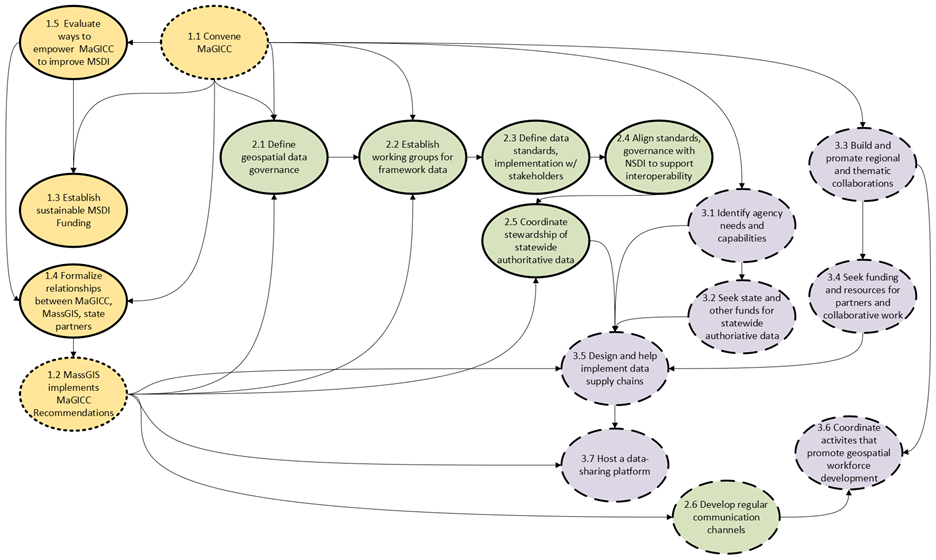
Funding is a dependency identified in many of the recommended actions. Pursuing the geospatial strategy without stable funding is risky because it may involve effort that is productive in the near-term but fails in later years. However, funding for actions that further the strategy is needed incrementally, as shown in Figure 3. A subsequent funding need follows to support statewide authoritative data (above current funds already doing so). As a formal governance framework is built for the stewardship, creation, and maintenance of authoritative datasets, it will be possible to estimate those costs (Recommendation 3.2). Depending on how stewardship, creation, and maintenance are situated in the governance framework for any given dataset, regional and thematic collaborations, partnerships, agreements, and co-production of spatial data may also need funding (Recommendation 3.4) as part of building stable data supply chains (Recommendation 3.3). Regional collaborations and other partnerships may also need funding for purposes other than statewide authoritative data. Funding and resources for partners and collaborative work (Recommendation 3.4) are potential future costs that will need to be estimated later in the implementation of the geospatial strategy.
Milestones
The table in Figure 4 indicates the high-level deliverables and the approximate milestone dates for which those deliverables are expected to be achieved. Some of the objectives in the plan are ongoing, thus there are not discrete deliverables or milestones for those objectives. A business plan be developed for each of the three goals in the Strategy. The business plans will contain more detailed implementation objectives and deliverables, along with more specific timelines and dates for each deliverable.
Figure 4. Deliverable and Milestones
| Objective | Deliverable | Milestone |
|---|---|---|
| Objective 1.1 | Convene the Massachusetts Geospatial Information Coordinating Council | June 2025 |
| Objective 1.3 | Establish sustainable MSDI funding | July 2027 |
| Objective 2.1 | Define geospatial Framework data themes | Aug 2025 |
| Objective 2.1 | Prioritize Framework data themes | Nov 2025 |
| Objective 2.2 | Convene Framework Implementation Team | Sept 2025 |
| Objective 2.3 | Draft geospatial data governance guideline | March 2026 |
| Objective 2.3 | FIT/MaGICC adopt governance guideline | June 2026 |
| Objective 2.6 | Develop MaGICC communication plan | Nov 2025 |
| Objective 2.6 | Initiate MaGICC communication channels | Dec 2025 |
| Objective 3.1 | Assessment of agency GIS needs and capabilities | June 2026 |
| Objective 3.2 | Operational funding for Framework program | July 2026 |
| Objective 3.5 | Data supply chain study | June 2026 |
The combination of MassGIS and MaGICC is the engine driving the strategy; since MassGIS has been operational for many years, convening MaGICC is the first action and deliverable. As a coordinating body, it will take some time for MaGICC to create its own processes. So, approximately 6 months after it is convened, MaGICC and MassGIS will begin to formalize how they work together. Once this relationship is established, many other actions follow, with MassGIS working with MaGICC. The implementation for Goal 1 emphasizes the importance of MaGICC, MassGIS and institutionalizing their relationship by having this occur as quickly as possible.
Goal 2 concerns governance of geospatial data, including standards, for MSDI and other authoritative data themes. Governance is an important need that MassGIS and MaGICC address early in the strategy. Massachusetts already has built working groups for several MSDI themes, and these are incorporated into implementing Goal 2, allowing rapid progress on the larger work of defining geospatial data governance and standards. Substantial input from stakeholders’ adoption of policies and standards extends over several years. Communications with stakeholders – part of every goal in the strategy – are included under Goal 2 because governance relies on communications while building policies and standards, then publicizing and disseminating them.
Many deliverables in Goal 3 rely on Goal 1 and Goal 2 actions because its core is the creation of federated data systems for many of the authoritative data themes. This cannot be done without policies and standards, coordination, partnerships, and collaborations with data creators and editors at the local levels. Because the Commonwealth already has a robust process for some authoritative themes, some work can begin earlier, acting as a model for new themes and collaboration.
Measuring Achievement
While this plan presents a multi-year vision and set of recommendations, the conditions (organizational, political, technological) in which this plan was formed will evolve over time. It will be essential to revisit the plan periodically and to recalibrate priorities based on what has been achieved, as well as new developments. Ultimately, strategic planning – particularly for technology – must be viewed as an ongoing effort and not a one-time exercise. We recommend a collaborative, quarterly review of the strategic goals and recommendations with input from both MassGIS and the Council to (1) assess progress as compared to the schedule/priorities presented in this plan and (2) recalibrate goals based on new information/circumstances. This quarterly snapshot should be captured using the following chart (Table 4), or a similar rubric. Ratings are based on a qualitative assessment, all things considered.
Table 4. Rubric for measuring progress toward strategic goals
| Strategic Goal | Overall Goal Status (Color-Code)* | Recommendations | Comment or Suggested Recalibration (Color-Code for Recommendation Status)* |
|---|---|---|---|
| 1. MaGICC will provide collaborative community influence for its recommendations on the MSDI and have a clearly defined relationship to MassGIS. | to be filled in | 1.1 Convene MaGICC | to be filled in |
| 1.2 MassGIS Implements MaGICC Recommendations | to be filled in | ||
| 1.3 Establish sustainable MSDI funding | to be filled in | ||
| 1.4 Formalize relationships between MaGICC, MassGIS, and state partners | to be filled in | ||
| 1.5 Empower MaGICC in pursuit of its mission to improve the MSDI | to be filled in | ||
| 2. MaGICC will coordinate the creation of data governance policies, with stakeholder participation, for authoritative base geospatial data themes. | | 2.1 Define geospatial data governance outcomes that are consistent with state policies. | to be filled in |
| 2.2 Establish working groups for framework data themes | to be filled in | ||
| 2.3 Define data standards and implementation strategies with community stakeholders | to be filled in | ||
| 2.4 Align standards and governance with National Spatial Data Infrastructure to support interoperability | to be filled in | ||
| 2.5 Coordinate stewardship of statewide authoritative data | to be filled in | ||
| 2.6 Develop regular communication channels | to be filled in | ||
3. MaGICC and MassGIS will facilitate stakeholder access to resources needed to contribute to statewide authoritative data. | | 3.1 Identify government agency needs and capabilities | to be filled in |
| 3.2 Seek state funds to support statewide authoritative data | to be filled in | ||
| 3.3 Build and promote regional and thematic collaborations | to be filled in | ||
| 3.4 Seek funding and resources for partnerships and collaborative work. | to be filled in | ||
| 3.5 Design and help implement data supply chains | to be filled in | ||
| 3.6 Coordinate activities that promote geospatial workforce development | to be filled in | ||
| 3.7 Host a data-sharing platform | to be filled in |
*Color Key (during operational use, cells in the preceding table will be color-coded and comments added as appropriate).
Color: Rating
Blue: Not yet started
Green: Fully meets expectations and requirements (e.g., on schedule and achieving desired outcome)
Yellow: Partially meets expectations and requirements (e.g., behind schedule, but making reasonable progress toward desired outcome)
Conclusion
The Massachusetts Geospatial Strategy is aimed at further developing and sustaining the geospatial ecosystem that has been in development in the Commonwealth for several decades. The strategic goals and objectives create a foundation, through collaborative governance that is formalized and appropriately empowered, to continually improve current statewide data themes, and to develop new data themes. The ultimate vision for this geospatial ecosystem is to support consistent delivery of government services across the Commonwealth and make it easier to do business in Massachusetts. Through the implementation of the Massachusetts Geospatial Strategy, state and local governments, educational institutions, organizations, industries, and residents will continually have access to high-quality, authoritative, statewide geospatial data and the geospatial infrastructure to make use of these data in ways that enable and sustain the ecosystem and ultimately achieve the vision.
As noted, MassGIS and MaGICC are key partners in performing many of the actions needed to achieve the three strategic goals and associated objectives. Several of the recommended actions appearing in many goals emphasize the need for this partnership to be well-structured and supported in Commonwealth policy and funding. Partnerships, collaborations, and shared data supply chains will also need supporting resources, funding, and technical assistance. As outlined in the goals and recommendations, MassGIS and MaGICC are the orchestrators of these efforts. Together, they form a nexus for statewide geospatial development. The ultimate outcome of these three goals is for the Commonwealth to have a way to keep authoritative data refreshed, build new kinds of data, and use geospatial data in innovative analyses and solutions, thus enhancing the state’s geospatial ecosystem.
| Last updated: | August 14, 2025 |
|---|