Overview

Wayne F. MacCallum WMA in Westborough, MA
MassWildlife works in partnership with the Department of Fish and Game (DFG) to protect the Commonwealth’s most important fish and wildlife habitat and to expand the public's access to land and inland waters for wildlife-related outdoor recreation, including fishing, hunting, trapping, hiking, skiing, paddling, nature photography, and wildlife watching. The land protection program works from the forests of the Berkshires to the salt marshes along the northeast coast, and everything in between. To connect habitat and allow plants and animals to adapt to changing climate conditions, acquisitions build upon existing Wildlife Management Areas and other protected lands and create new strongholds that can be built on in the future. Some lands are acquired with an intent to restore and manage them for particular habitat types, others may receive a more passive management approach, and all are open for the public to enjoy. Protecting these lands also improves climate resiliency by protecting forests and wetlands that absorb carbon dioxide and floodwaters in extreme weather events.
The program purchases land in-fee or conservation restrictions (CRs) from willing landowners who seek to conserve their property. Annual funding for these acquisitions includes capital funds from the Environmental Bond and the Wildlands Stamp Fund, which is supported by a $5 fee added to each purchase of a hunting, fishing, or trapping license. In addition, the program secures state and federal grants and receives support from incentive programs, as well as generous gifts from private landowners and other conservation partners.
Types of properties:
- Wildlife Management Area (WMA): Land owned outright by DFG/MassWildlife. Open to the public for hunting, fishing, trapping and other passive recreation. Subject to Wildlife Management Area Regulations.
- Wildlife Conservation Easement (WCE): Land subject to an agreement between DFG/MassWildlife and landowners that permanently protect their properties and open them to the public for non-motorized recreation, including hunting, fishing, trapping, and other passive recreation.
Land protection over time
Each year MassWildlife works to expand protection of lands that conserve key fish and wildlife habitats and enhance public access to wildlife-related outdoor recreation. The chart below shows the progress we've made over the last decades.
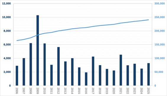
The dark blue bars show the number of acres protected in a given year. The light blue line shows how the total acres of conserved land has grown over time. Fluctuations in yearly acquisitions are caused by a number of factors including availability of funding, differences in property values across MA, and whether land is gifted to the agency.
2025 land protection achievements
Land acquisition staff from MassWildlife and DFG collaborated on 31 projects during the last fiscal year (July 1, 2024 – June 30, 2025), protecting over 3,200 acres of forests, grasslands, water frontage, and inland water access points. This brings the total amount of land protected and managed by MassWildlife to over 239,000 acres. Just over $11.4M from six different funding sources, including $1.37M from the Wildlands Stamp Fund, nearly $6M in one time American Rescue Plan Act funding, and generous gifts, made these acquisitions possible.
FY25 acquisition locations
| District | Site | Total acreage protected |
|---|---|---|
| Central | Browning Pond Access*, Moose Brook WCE, Muddy Brook WMA, Winchendon Springs WMA | 995.39 |
| Connecticut Valley | Brushy Mountain WMA, Flynt Mountain WMA*, Great Swamp WMA, Honey Pot WMA, Rattlesnake Mountain WMA*, Tully Mountain WMA | 485.45 |
| Northeast | Ashby WMA, Crane Pond WMA, Nissitissit River WCE, Squannacook River WMA, Townsend Hill WMA, Unkety Brook WMA | 301.53 |
| Southeast | Poor Meadow Brook WMA, Puddingstone WMA, Sippican Headwaters WCE | 557.34 |
| Western | Bungy Mountain WMA*, Flat Brook WMA, Hiram H. Fox WMA, Hog Mountain WMA*, Maple Hill WMA, Rockdale Highlands WMA*, Savoy WMA, Shaker Mill Brook WMA*, Tekoa Mountain WMA | 936.47 |
*New site in fiscal year 2025.
Highlights
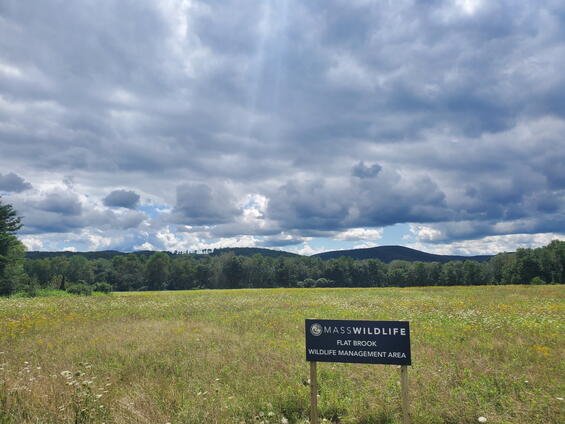
Flat Brook WMA in West Stockbridge, MA
Western: In West Stockbridge, 73 acres were added to Flat Brook WMA to enhance the site’s recreation opportunities. Already a beloved pheasant stocking location, Flat Brook has been the site of recent grassland restoration efforts. The new parcel will allow MassWildlife to maintain quality pheasant hunting through the season while grassland restoration is conducted on the original WMA acreage. Eventually, fields in this new parcel will also be restored, providing even more grassland habitat, alongside the WMA’s wetlands complex comprised of Flat Brook, Cranberry Pond, and Crane Lake, to support rare and game species alike and all those who enjoy them.

Rattlesnake Mountain WMA in Holland, MA
Connecticut Valley: Recent acquisitions in Monson (~65 acres) and Holland/Wales (~290 acres) have created new WMAs where MassWildlife has traditionally been underrepresented. Both the Flynt Mountain WMA and Rattlesnake Mountain WMA, respectively, provide excellent access from nearby roads, as well as an array of upland and lowland habitat types that support both game species and specialized natural communities. The Flynt Mountain WMA is also located near a Monson-based processor for the Hunters Share the Harvest Program, making it easy for local hunters to donate their deer harvest to families in need.

Winchendon Springs WMA in Winchendon, MA
Central: In a tremendous partnership effort, DFG/MassWildlife, Department of Conservation and Recreation, Mass Audubon, Mount Grace Land Conservation Trust, and local leaders conserved 1,325 acres of forests, fields, and wetlands in Winchendon and Ashburnham. Through this project, nearly 890 acres were added to the 1,500-acre Winchendon Springs WMA, conserving priority habitat for five state-listed species, frontage on the Millers River and Estees Brook - both designated Coldwater Fisheries Resources with high fish diversity – and a healthy, diverse forest that supports American woodcock and ruffed grouse. The land also connects to DCR’s nearly 3,000-acre Ashburnham State Forest, creating a continuous forest corridor that stretches north to Lake Monomonac and other protected lands in New Hampshire.

Unkety Brook WMA in Groton, MA
Northeast: Over 94 acres in Groton were added to the ever-growing Unkety Brook WMA – which is now over 900 acres. These parcels also directly abut hundreds of acres of conservation land owned by the Town of Groton and the New England Forestry Foundation. These lands are home to four state-listed species, multiple vernal pools, as well as Unkety Brook, a designated Coldwater Fisheries Resource. Their diversity of habitats, including ponds, deep marsh, shrub swamp, shallow marsh, deciduous wooded swamp, and mixed upland forest, make them important for safeguarding biodiversity and providing wildlife-based recreation.

Puddingstone WMA in Taunton, MA
Southeast: In an ongoing partnership with the City of Taunton, nearly 50 acres across two parcels were added to Puddingstone WMA, totaling the WMA to 200 acres. Both parcels abut the City’s 280+/- acre Arthur Sharp Estate conservation land, are located within half a mile of an Environmental Justice Community, have excellent pedestrian access, and provide hunting opportunities. In addition to providing recreational opportunities near an urban area, these acquisitions also conserve dramatic Puddingstone glacial erratic boulders and bedrock outcrops. The acquisition also protects priority habitat for rare species, uplands, wetlands, and streams.
In addition to the partners mentioned above, special thanks go to the Buzzards Bay Coalition, East Quabbin Land Trust, Kestrel Land Trust, Nashua River Watershed Association, Stockbridge Land Trust, and the Town of Pepperell for their significant contributions to projects completed in fiscal year 2025.