Preface
Resource Management Plans (RMPs) are foundational documents that identify a park, forest, or reservation’s defining natural, cultural, and recreational resources and identify potential threats and opportunities to guide DCR’s continued stewardship of the property and to inform future decisions about the property in a way that celebrates and preserves its identity.
RMPs are prepared for “all reservations, parks, and forests under the management of the department” (M.G.L. c. 21, § 2F). These plans “shall include guidelines for the operation and land stewardship of the aforementioned reservations, parks and forests, shall provide for the protection and stewardship of natural and cultural resources and shall ensure consistency between recreation, resource protection, and sustainable forest management.” DCR finalizes RMPs following a public process and adoption by the DCR Stewardship Council. The contents of this RMP represent the best available information at the time of adoption by the Stewardship Council.
Mission and Core Principles
The Massachusetts Department of Conservation and Recreation, an agency of the Executive Office of Energy and Environmental Affairs, oversees 450,000 acres of parks and forests, beaches, bike trails, watersheds, dams, parkways, and over 100 National Register listed properties. The agency’s mission is to protect, promote, and enhance our common wealth of natural, cultural, and recreational resources for the well-being of all.
DCR strives to be an exemplary leader in conservation and recreation. DCR’s staff is passionate, dedicated, and continuously employs best practices, expertise, and a sense of place in carrying out the mission. The following core principles ground the agency in its work. For the benefit and well-being of all—people and the environment—DCR pledges to:
- Provide access to a diversity of outdoor recreational experiences and unique landscapes that is equitable, inclusive, and welcoming.
- Conserve lands, water, and forests by integrating science, research, and technical expertise into the management of our natural resources.
- Advance climate change mitigation and adaptation efforts by implementing sustainable practices and advancing resiliency across our infrastructure, assets, and resources.
- Support healthy communities by providing places for people to connect with nature and each other.
- Inspire generations of stewards by recognizing and honoring our legacy through partnerships, public engagement, and education.
Stewardship
DCR honors Indigenous peoples for their care, throughout many generations, of the land that DCR now stewards on behalf of the people of the Commonwealth. DCR embraces this legacy of stewardship, fostering a sense of shared responsibility by all people for protection of the waters, lands and living things for the enjoyment and appreciation of all.
To learn more about the DCR, its facilities, and programs please visit our web page or contact us at mass.parks@mass.gov
Summary Tables
1. Property Overview
| Characteristic | Value |
|---|---|
| Date Established | 1988 |
| Location | Boston (West Roxbury) |
| Ecoregion | Boston Basin, Southern New England Coastal |
| Watershed | Charles |
| DCR Region | Boston |
| DCR District | Boston |
| DCR Complex | Stony Brook |
| Management Forestry District | Southeast |
| Fire Control District | S. Middlesex County |
| Size (acres) | 145.8 |
| Boundary Length (miles) | 3.4 |
| Elevation - Minimum (feet) | 84 |
| Elevation - Maximum (feet) | 150 |
| Environmental Justice (acres) | 145.8 |
| Estimated Annual Attendance (2025) | Unknown |
| Interpretive Programs (number of programs, 2025) | 0 |
| Interpretive Programs (number of attendees, 2025) | 0 |
2. Landscape Designations
| Designation | Acres |
|---|---|
| Parkland | 145.8 |
| Reserve | 0.0 |
| Woodland | 0.0 |
| No Designation | 0.0 |
3. Regulatory Designations
| Designation | Acres |
|---|---|
| Boston Landmark | 145.8 |
| National Register of Historic Places – Brook Farm | 145.8 |
| National Historic Landmark – Brook Farm | 145.8 |
| Priority Habitat (MESA) | 139.8 |
4. Long-Term Agreements
| Agreement | Expiration Year |
|---|---|
| None identified | N/A |
5. Concessions
| Concession Type |
|---|
| None |
6. Partners & Friends
| Group |
|---|
| Boston Women’s Heritage Trail |
| City of Boston Archaeology Program |
| Gethsemane Cemetery |
| New Brook Farm |
| Newton Conservators |
7. Features of Interest
| Feature |
|---|
| Blue Heron Trail |
| Brook Farm Utopian Community site |
| c. 1890 Print Shop |
| Civil War-era Camp Andrew munitions storage magazine and site marker |
| Lutheran Orphanage archaeological site |
| Sawmill Brook |
| Views of the Charles River |
8. Natural Resources
| Resource | Number |
|---|---|
| Tree Canopy (acres) | 88.2 |
| Rivers and Streams (miles) | 0.1 |
| Open Water (acres) | 0.0 |
| Wetlands (acres) | 88.6 |
| Certified Vernal Pools (number) | 5 |
| Potential Vernal Pools (number) | 6 |
| State-listed Species (number Regulatory) | 2 |
| State-listed Species (number Non-Regulatory) | 0 |
| Federally Listed Species (number) | 0 |
| Aquatic Invasive Plants (number of known species) | 1 |
| Terrestrial Invasive Plants (number of known species) | 14 |
9. Forest Management (Since 2012)
| Management Objective | Acres |
|---|---|
| N/A | 0.0 |
10. History of Wildfires and Conditions Influencing Future Wildfires
| Wildfire Attribute | Number or Value |
|---|---|
| Number of wildfires on property; 2020–2024 | 0 |
| Acres burned by wildfires on property; 2020–2024 | 0.0 |
| Number of wildfires in Fire Control District; 2020–2024 | 530 |
| Acres burned by wildfires in Fire Control District; 2020–2024 | 353.1 |
| Type of Wildland-Urban Interface | No data |
| Predicted rate of spread, based on Fire Behavior Fuel Model 13 | Moderate to quick |
11. Natural Hazards
| Hazard Type | Acres |
|---|---|
| Flood (1.0%-chance) | 101.3 |
| Flood (0.2%-chance) | 103.7 |
| Hurricane Inundation (Category 1) | N/A |
| Hurricane Inundation (Category 4) | N/A |
12. Climate Change (By 2070)
| Type of Change | Amount of Change |
|---|---|
| Increase in annual days above 90° F | >30 |
| Change in annual maximum daily rainfall (inches) | >10 |
| Massachusetts Coastal Flood Risk Model area of inundation (acres) | N/A |
13. Cultural Resources
| Resource Type | Number |
|---|---|
| Archaeological - listed in the Massachusetts Cultural Resource Information System (MACRIS) | 17 |
| Historical - Listed in MACRIS | 12 |
| Boston Landmark | 1 |
| National Register-listed | 12 |
| National Historic Landmark | 1 |
14. Recreation Resources
| Resource | Number |
|---|---|
| Sawmill Brook Access | 1 |
| Open Meadow Areas | 2 |
| Trail System | 1 |
15. Recreation Activities
| Activity |
|---|
| Bicycling, mountain |
| Dog walking, on leash |
| Heritage tourism |
| Hiking/Walking |
| Nature study/Photography |
| Running/Jogging |
| Skiing, cross-country |
| Snowshoeing |
| Wildlife viewing |
16. Roads and Trails
| Metric | Number |
|---|---|
| Roads - Unpaved (miles) | 0.0 |
| Roads - Paved (miles) | 0.5 |
| Forest Roads - Unpaved (miles) | 0.0 |
| Forest Roads - Paved (miles) | 0.0 |
| Trails - Unpaved (miles) | 1.1 |
| Trails - Paved (miles) | 0.0 |
| Trails - Unauthorized (miles) | 1.7 |
| Trail Density (miles/acre) | 0.019 |
| Area of Impact (acres) | 79.6 |
17. Parking
| Parking Resources | Number |
|---|---|
| Lots | 2 |
| Parking Spaces - Total | 11 |
| Parking Spaces - Accessible (HP) | 0 |
| Parking Spaces - Other | 11 |
Introduction
Brook Farm Historic Site (Brook Farm or the Park) is a 145.8-acre property in Boston’s West Roxbury neighborhood, owned by the Department of Conservation and Recreation and managed for passive recreation. The Park comprises pre-contact and post-contact archaeological sites, the c. 1890 Print Shop associated with the Lutheran organization and Orphanage, mature trees, small fields and lawns, limited trails and an access road, rock outcrops, and Sawmill Brook and the wetlands of the Sawmill Brook corridor. Primary access is from Baker Street, near DCR’s Veterans of Foreign Wars (VFW) Parkway. (See Figure 1.) The site is neighbored by private cemeteries to the north, east, and south including The Gardens at Gethsemane Cemetery (Gethsemane Cemetery or The Gardens) inholding at its center. The Park borders Charles River to the west and the City of Boston’s Millennium Park to the south, which serves as a common approach for visitors.
Brook Farm is widely recognized for its role in American social and intellectual history. Consequently, it is a National Historic Landmark ((NHL) the highest level of historic designation in the United States), is listed in the State and National Registers of Historic Places, and is a City of Boston Landmark. Founded in 1841 at the height of the Transcendental movement on land that had been used as a dairy farm in the eighteenth century, the Brook Farm Institute for Agriculture and Education (Brook Farm Institute) was an experimental, Utopian society of men, women, and children who had dreams of leading a more wholesome and simple life. The Farm’s members and visitors included renowned authors and philosophers Nathaniel Hawthorne, Charles Dana, Ralph Waldo Emerson, Henry David Thoreau, and Margaret Fuller. Later, the farm served briefly as an almshouse, then as a Civil War training camp, and then as a Lutheran orphanage for almost a century. Brook Farm has a complex, layered history representing centuries of human activity. Those seeking additional information on the history of Brook Farm are directed to the Boston Landmarks Commission’s (BLC) report on Brook Farm (BLC 1977).
The First Peoples. Archaeological and other evidence shows that Indigenous people have lived on the present-day Brook Farm land for at least 5,000 years. They fished along the Charles River with weirs for alewives and shad, used nearby ponds (Hammond’s, Wiswall’s, Bullough’s), hunted in surrounding woodlands, and practiced horticulture on arable lands. Between 1616 and 1630 numerous epidemics of European diseases decimated Native populations, primarily with smallpox affecting the Native populations surrounding the Boston Bay area. Surviving communities in the region were often-times coerced into conversion to Christianity and subsequently formed Christian communities on the outskirts of Boston (formally praying-towns in 1651) as means of survival against continuing European encroachment and conflict in the region. Praying-towns in the Boston region were amalgamations of Nipmuc and Wampanoag communities and their descendants. In 1637, Massachusetts Bay Colony set aside land at Nonantum near Brook Farm (present-day Newton Corner) (Kelly and Olson 2022 and publications cited therein; Massachusetts Historical Commission (MHC) 1982) for Waban, a local leader and his Christianized followers. In 1651, Waban and his community at Nonantum were removed to the Natick praying-town (Lopenzina 2006).
After the Native community was relocated, the Brook Farm land was not immediately settled by Euro-American colonists, as it had been deemed unsuitable for agriculture. The land was eventually purchased in the late seventeenth century by John Ward, one of the residents of Newton (Drake 1878; Kelly and Olson 2022). As of 2026, Brook Farm falls in the tribal areas of interest of three tribal governments: the Mashpee Wampanoag Tribe (federally recognized tribe); the Wampanoag Tribe of Gay Head (Aquinnah) (federally recognized tribe); and the Hassanamisco Nipmuc Band (state recognized tribe). One Indigenous Community Stakeholder, the Massachuset Tribe at Ponkapoag (a descendant community) has expressed interest in this area.
The Dairy Farm. In 1701, John Ward gifted the original 100-acre Brook Farm property to his son Edward. Edward likely used the land as a dairy farm, and his family resided on the property in a farmhouse (later called the “Hive”) near present-day Baker Street. The farm was passed down through the Ward family until the late eighteenth century, when it was acquired by the Richards and then the Mayo families. The Mayo family also acquired neighboring parcels of land and consolidated Brook Farm into a 170-acre property (Kelly and Olson 2022). During its time as a dairy farm, the Brook Farm land was a working New England farm: open fields and meadows framed by stone walls and woodlots, watered by Sawmill Brook and nearby ponds, and reached by the old Dedham (Baker) Street corridor. Construction of a sawmill on Sawmill Brook in 1683 and improved roads tied the farm more closely to Roxbury’s town center. By the 1830s—under Charles and Maria Ellis—the property was a compact, productive landscape of fields, pastures, orchards, and lanes that would soon host the Brook Farm utopian experiment.
Transcendentalism and the Utopian Community. Brook Farm Institute for Agriculture and Education (1841–1847) was one of America’s most famous utopian experiments. The utopian community was founded by George and Sophia Ripley and members of the Boston-based Transcendental Club to test Transcendentalist ideals in the work and rhythms of a real farm and school. On the Ellis dairy landscape, the community used existing buildings (the “Hive” farmhouse and barn) and added the Nest (for the school), the Eyrie, Margaret Fuller Cottage, Pilgrim House, a workshop, and a greenhouse. Members shared farm labor, taught in a co-educational school, and turned the property’s fields, lanes, and brooks into both workplace and classroom, balancing haying and dairying with lectures, theater, music, and long walks to the Charles (Schultz 1988; Kelly and Olson 2022; Pendery and Preucel 1992).
In 1844 Brook Farm Institute embraced Fourierism, a radical philosophy of social reform, and built a large central residence—known as the Phalanstery—to anchor a more structured community. The building’s destruction by fire in March 1846 ended the experiment under the weight of new debts. Though short-lived, Brook Farm Institute proved nationally influential: its cooperative economy, progressive education, and vigorous print culture (including a weekly journal called The Harbinger) helped carry Transcendental and reform ideas into public life, while literary afterlives—Hawthorne’s The Blithedale Romance and the community’s letters and diaries—cemented the site’s significance in American intellectual history (Schultz 1988; Kelly and Olson 2022; Pendery and Preucel 1992).
Almshouse. Following the collapse of the utopian community, the City of Roxbury purchased the Brook Farm Institute property at public auction in April 1849 for $19,150 to operate a public almshouse. A city report at the time inventoried multiple buildings on the property that were used to house Roxbury’s most needy. In 1854, most of the paupers living at the almshouse were moved to the new State Almshouse. The almshouse at Brook Farm was then closed after the Hive burned down later that year (Kelly and Olson 2022). At the time of its closure, industrialization and rail access were reshaping the West Roxbury area: small farming was declining, large tracts were being subdivided for housing, and increasing numbers of residents commuted to Boston for work (MHC 1981).
Civil War Camp. In 1855, the Reverend James Freeman Clarke—once aligned with the Transcendentalists and later a leading abolitionist—purchased the Brook Farm land and, at the outset of the Civil War, loaned it to the Commonwealth as Camp Andrew. The Camp was located primarily within what is now Gethsemane Cemetery. The Second Massachusetts Infantry under Col. George H. Gordon arrived on May 11, 1861, using the site’s accessible yet secluded, level grounds for company streets, a broad parade and drill field, a guardhouse at the entrance, officers’ headquarters with a hospital behind it, cookhouses, river bathing, and a hollow for worship (Gordon 1883; Kelly and Olson 2022). The regiment departed on July 8, 1861, after which the camp closed. The Second Massachusetts later distinguished itself at Cedar Mountain, Antietam, Chancellorsville, Gettysburg, and Atlanta. Robert Gould Shaw began his service at Camp Andrew as an officer in one of the Second Massachusetts’ companies and would later become famous for leading the 54th Massachusetts Regiment (Kelly and Olson 2022).
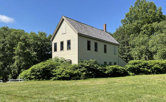
Lutheran Orphanage and other Social Services. The Lutheran Services Organization established the Martin Luther Orphan’s Home at Brook Farm in 1872 and provided various social services on site until 1944. The Pilgrim House and workshop buildings that had been built by the utopian community were relocated and combined into the main part of the orphanage (Kelly and Olson 2022). Services expanded when Gethsemane Cemetery was laid out in 1873, and the Home began operating a printing works—culminating in the construction of the Print Shop (1890) where Bibles, postcards, and pamphlets were produced until 1924. The Lutheran organization also hosted annual community picnics for local German societies. After the orphanage closed in 1943, the property was briefly loaned to the Commonwealth (1944–1948) for foster care, then reopened in 1948 as the Brook Farm Home, a small residential treatment center and school for children with special needs. Through the 1950s–1970s, related uses continued on the campus (including a Gethsemane Cemetery office and a caretaker living in the Margaret Fuller Cottage), marking a long chapter in which Brook Farm served vulnerable children and anchored community life along Baker Street (Kelly and Olson 2022; Pendery and Preucel 1992).
Brook Farm Today. In 1973 the Massachusetts General Court (MGC 1973) directed the Metropolitan District Commission (MDC, a predecessor agency to DCR) to acquire Brook Farm “for conservation, natural water storage of flood waters, historic, scenic, and passive recreational purposes” (MGC 1973). (A copy of this Act of the Legislature is provided in Appendix A.) This began a decade-plus negotiation with the Lutheran Services Association while local advocates and the West Roxbury Historical Society fended off private development proposals. Despite setbacks, including fires that destroyed the orphanage (1977) and later the vacant Margaret Fuller Cottage (1984), state commitment held. In 1987, a $3 million capital outlay authorized purchase and the transaction closed in 1988 (Kelly and Olson 2022; Schultz 1988). The acquisition created three parcels – Parcel A: Print Shop area and about 148 acres transferred to the Commonwealth for recreation and flood storage; Parcel B: Access road and Cemetery office/residence transferred to the Commonwealth with an easement to Cemetery; and Parcel C: Gethsemane Cemetery retained by the sellers (Allen & Major Associates 2025). (See Appendix B for a map of Brook Farm showing the locations and boundaries of Parcels A, B, and C.)
Management authority and responsibility vary among the parcels. Parcel A is under the management of DCR (successor agency to the MDC), and Parcel C is under the management of The Gardens. The 1984 Order of Taking established the following governance for the management and use of Parcel B (Suffolk County Registry of Deeds Book 15055 Page 329). “Reserving, however, to the Lutheran Services Association of New England, Inc., (hereinafter “Lutheran Services Association”), its heirs, successors and assigns, as appurtenant to parcel “C”, the right to pass and repass for all purposes for which streets and public ways are used in the City of Boston over Parcel “B”, as described below for access to and egress from Parcel “C” to and from Baker Street, the same to be used by the Lutheran Services Association, its heirs, successors, assigns and invitees for all of the usual and customary purposes for which it has been used in connection with the ownership, operation and maintenance of Gethsemane Cemetery including, but not limited to, the installation, maintenance and repair of all necessary utilities in connection therewith. In addition, there is reserved to the Lutheran Services Association, its heirs, successors and assigns the right to use and maintain at the Lutheran Service Association’s expense those buildings, structures and improvements located on said parcel “B” in connection with the operation of the cemetery for so long as it shall be operated, the Lutheran Services Association not to remove or destroy any of said structures without the consent of the Metropolitan District Commission. All general maintenance of any roadways over said Parcel “B” shall be the responsibility of the Metropolitan District Commission; however, snow plowing shall be the responsibility of the Lutheran Services Association for so long as the Lutheran Services Association, its heirs, successors and assigns, shall operate Gethsemane Cemetery.” More than fifty years after the taking, this language remains the sole guidance on the use and management of Parcel B.
Brook Farm benefits from an informal relationship with Cemetery staff who provide supplemental maintenance, such as litter removal and removal of pet waste.
Park Identity
Brook Farm Historic Site is defined by its nationally significant cultural landscape; a 145.8-acre DCR property whose identity centers on the Transcendentalist/Utopian community’s archaeological remains, the c.1890 Print Shop of the later Lutheran orphanage, and the wetlands and woodlands along Sawmill Brook. Due to the Park’s local, state and national historical significance, all future actions should prioritize protection of the historic landscape and archaeological resources, preservation of the Print Shop, interpretation of the site’s significant resources, stewardship of woodland and wetland ecosystems, storage of flood waters, and passive recreation.
Defining Resources and Values
Resources and values that define the site are tied to its nationally significant cultural landscape, Sawmill Brook corridor, and regional trail connections. They include:
- National Historic Landmark status and listing on the State and National Registers. (Listings include both Brook Farm Historic Site (Parcels A and B) and the Gardens Cemetery (Parcel C).)
- Designation as a City of Boston Landmark. (Listing includes both Brook Farm Historic Site (Parcels A and B) and the Gardens Cemetery (Parcel C).)Transcendentalist/utopian archaeological resources and landscape features (stone walls, stone and earthen foundations, cellar holes, historic lanes, field openings).
- The c.1890 Print Shop from the Martin Luther Orphans’ Home era.
- Camp Andrew (1861) Civil War training-ground associations.
- Proximity to other DCR properties, including Cutler Park Reservation, portions of Charles River Reservation, and the National Register listed Veterans of Foreign Wars (VFW) Parkway.
- Brook Farm is set in a landscape dominated by cemeteries. It surrounds The Gardens at Gethsemane and is bordered by the Baker Street Jewish Cemeteries to the north and west, St. Joseph Cemetery to the north, and St. James the Apostle Cemetery to the east.
- Nearly 140 acres, or about 96% of the Park, is designated Priority Habitat under the Massachusetts Endangered Species Act (MESA). Two state-listed species, a Threatened aquatic plant and a Species of Special Concern amphibian have been documented on the property.
- Brook Farm contributes towards protecting floodplain and numerous natural resources, including Sawmill Brook, forested and non-forested wetlands, five certified vernal pools, and Brook Farm Pond.
- Although not officially part of the U.S. Army Corps of Engineers’ (USACE) Charles River Valley Natural Storage Area, Brook Farm helps store flood waters from the Charles River and Sawmill Brook. More than 69% of Brook Farm is located within the 0.1%-chance flood zone.
- Passive recreation experiences, such as walking and birding along trails and fields in a scenic and tranquil landscape adjacent to cemeteries, the Charles River, and Millennium Park.
- The Blue Heron Trail, a multi-town, multi-partner trail network that provides a connection between Boston, Newton, Needham, and Dedham. DCR’s Cutler Park Reservation and Charles River Reservation, the City of Boston’s Millennium Park, and the USACE’s Charles River Flood Control Area and Charles River Wildlife Management Area may be accessed via this trail.
- The park provides recreational amenities to, and enhances environmental quality and equity for, an Environmental Justice (EJ) community.
Statements of Significance
Statements of Significance describe the importance or distinctiveness of a place and its resources (National Park Service (NPS) 1998). These statements reflect current scholarly inquiry and interpretation and go beyond a simple listing of resources to include contextual information that makes the facts more meaningful. When developing significance statements, the following criteria are considered:
- The property’s significance at the time of its establishment.
- How the property, or society’s understanding of the property, has changed since its acquisition that makes it significant or unique within the state park system today.
- The property’s role in recreation and its importance to the community it supports, particularly regarding activities that are unique to that property.
For park planning, these statements focus management actions on the preservation and enjoyment of those attributes that most directly contribute to the importance of the place. For interpretive planning, they comprise the information upon which the interpretive themes and overall program are built.
The following Statements of Significance have been identified for Brook Farm Historic Site. The sequence of these statements does not reflect their level of significance.
- Brook Farm Historic Site is recognized as the location of the Brook Farm Institute for Agriculture and Education (1841–1847), one of the best-known cooperative communities in American history, and listed as a National Historic Landmark.
- The site represents a direct link to the Transcendentalist movement, which reshaped American religious, philosophical, and political life in the 19th century.
- The history of Brook Farm and its remnant structures reflect a continuous theme of social consciousness and reform across its various uses, evolving from a utopian experiment into an almshouse, a Civil War training camp, and an orphanage.
- The site, primarily within the Gethsemane Cemetery, was home to Camp Andrew in 1861, serving as a training ground for the Second Massachusetts Infantry Regiment, whose soldiers distinguished themselves in battles such as Gettysburg and Atlanta during the Civil War.
- The 145.8-acre Brook Farm Historic Site has a long history of human occupation and land use with archaeological research indicating Indigenous presence beginning approximately 5,000 years ago, associated with settlement within the Charles River drainage, especially at the intersection of Sawmill Brook and the Charles River.
- Brook Farm is part of a larger corridor of protected areas, together with Sawmill Brook, Charles River, and Charles River Reservation. These contiguous protected acres provide valuable priority habitat, including extensive marshes, red maple swamps, woodlands, and fields.
Unifying Theme
The Unifying Theme is a statement that ties a property’s stories together and shapes the overall interpretive message that DCR wants to share with visitors in their experience at the property. The theme provides an overarching conclusion for visitors to contemplate (Ham 2013) and answers the question “so what?” The theme guides all interpretation for the park, both personal (i.e., formal and informal interactions with visitors) and non-personal (e.g., exhibits, signage, brochures).
The Unifying Theme for Brook Farm Historic Site is:
- Beyond its Transcendentalist roots, Brook Farm embodies a broader theme of social reform and consciousness.
Visitor Experience
Brook Farm Historic Site provides a variety of visitor experiences, including the following:
- Virtual Experience. Potential visitors will find information about Brook Farm Historic Site on DCR’s web site. The Park has its own web page that identifies the Park’s location and lists Hiking and Educational programs as activities that visitors may enjoy here. The web page indicates a Picnic area on site, but no such amenity exists. There is a link to a brochure that contains information about the Park’s History, but there is no additional information to help potential visitors plan a trip.
- Entering the Park. The main entry to Brook Farm is from Baker Street through a gateway flanked by stone piers with a Cantilevered DCR Identification Sign to the right and a Gethsemane Cemetery sign to the left. This entrance accommodates vehicles, bicycles, and pedestrians, but many trail users entering Brook Farm from adjacent protected lands like Boston’s Millennium Park are unaware that they have crossed into the DCR property due to lack of signage. The main entry drive is shared by cemetery staff and visitors as well as park users. It first leads to the cemetery reception area and marked cemetery parking, and then to the c. 1890 Print Shop, where DCR visitor parking and a small interpretive kiosk with information about the park’s history are located. A secondary DCR parking area lies farther along the shared entry road; it lacks signage or delineated spaces but serves as the primary point of access to the trail system.
- Trail-based Passive Recreation. Visitors seeking recreational experiences may access a modest trail network. Just over one mile of official trails extends along the riverbank and through woodlands, providing visitors the opportunity for an easy hike or ride and park exploration. In addition, a segment of the Blue Heron Trail passes through Brook Farm, so that the property serves as an access point to the broader Blue Heron Trail system.
- Heritage Tourism. The Park’s connection to Transcendentalism draws many visitors to Brook Farm. The readily interpreted historic resources, such as the Print Shop, foundations, and former agricultural landscape, allow visitors to connect with Brook Farm’s history. Through New Brook Farm, guided tours and programs are offered throughout the year.
Threats and Opportunities
The following information identifies potential threats to the park’s natural and cultural resources and identifies opportunities to enhance their protection and stewardship. Although recreation is not considered a resource under statute (M.G.L. c. 21, § 2F), it is included below because recreation is an important part of the park-going experience, helps define a park’s values, and is a key part of assessing the consistency of activities taking place in the Commonwealth’s forests, parks, and reservations.
Threats and opportunities identified below are used to inform the development of management recommendations. Potential recommendations must meet prioritization criteria to be included in the Priority Recommendations table (Table 19).
Natural Resources
Threats
- The following 15 species of invasive plants (i.e., those plants categorized as Invasive by the Massachusetts Invasive Plants Advisory Group (MIPAG) (2025)) have been identified in the park (BSC Group, Inc. (BSC) 2017; Lucas Environmental 2025): autumn olive, black swallow-wort, burningbush, European buckthorn, garlic mustard, glossy buckthorn, Japanese barberry, Japanese honeysuckle, Japanese knotweed, multiflora rose, Norway maple, Oriental bittersweet, purple loosestrife, tree of heaven, and yellow iris. One species categorized by MIPAG (2025) as Likely Invasive, Amur cork-tree, is also present. Invasive species may negatively impact both the ecological integrity and biodiversity of the park, as may the following five species of management concern: butter-and-eggs-toadflax, Chinese wisteria, European lily-of-the-valley, European privet, European spindle-tree (Lucas Environmental 2025).
- The state-listed aquatic plant is disturbance dependent, sensitive to successional change, incompatible with woody encroachment, and threatened by invasive plants in wetlands and adjacent upland areas (Leddick 2026).
- Although actively managing the habitat of the state-listed aquatic plant can benefit the plant and help “forestall immediate and pending losses” (Leddick 2026), it has the potential to negatively impact breeding habitat for the state-listed amphibian through increased sedimentation, altered hydrology, and substrate alteration.
- An assessment of Brook Farm’s trees (Arbor LLC 2025) identified the following impact of invasive plants on the park’s native trees: stands of Japanese knotweed are limiting regeneration of native species and placing long-term stress on roots; vines, including Asiatic bittersweet, are climbing into tree canopies, increasing wind resistance and increasing the probability of limb or whole-tree failure during storms.
- Deferred structural pruning and utility conflicts have produced heavy end-weight and weak unions in select trees along paths and cemetery edges; several dead/dying specimens present elevated hazard potential (Arbor LLC 2025).
- Portions of the site lie within mapped FEMA floodplain (Massachusetts Bureau of Geographic Information (MassGIS) 2025), including along Sawmill Brook. Flooding can alter landforms and mobilize trash and sediment from adjacent properties.
- Within the wetland resource area and Priority Habitat, activities such as parking, vegetation management, and landscaping with non-native plants can impact habitat, water quality, and flood storage capacity and must be carried out in accordance with all pertinent environmental regulations and with formal DCR approval.
- The Massachusetts Department of Environmental Protection (MassDEP) has identified several water quality impairments in Sawmill Brook (Assessment Unit #MA72-23) within Brook Farm (MassDEP 2023), resulting in this stretch of the river being classified as not suitable habitat for sustaining a native, naturally diverse community of aquatic flora and fauna. Because MassDEP updates its Integrated List of Waters on a regular basis, readers are directed to refer to the most recent version of that document for current information.
- Adjacent private uses may result in impacts on shared natural resources. Stockpiling of materials, dumping, wind-blown debris (such as plastics and flowerpots), and possible pollutants from equipment or mowing operations have been observed on DCR land near wetlands and vernal pools, contributing to erosion, nutrient loading, and visual blight.
- Boundaries between the Gethsemane Cemetery and DCR lands are well marked but encroachments have been observed. In November 2025, existing property boundary markers were located and documented (Gregory 2025), with several encroachments and potential encroachments identified. Encroachments may result in portions of public land being unavailable or unsuitable for use by the public.
- Use of DCR property for private events without prior review and authorization may impact natural and cultural resources as well as visitor experience.
- A legacy leaf-and-soil stockpile and a former access route through a vernal pool may fragment habitat.
- Park visitors have created multiple unauthorized trails. Construction of trails without authorization or applicable regulatory review may threaten MESA-protected species’ habitat, natural communities, and ecosystem functions.
- Lack of trail maintenance on authorized trails has resulted in stormwater/erosion inputs to vernal pools and adjacent wetlands. Trails need to be properly maintained to protect natural resources.
- There are at least two unapproved geocaches in the park. Inappropriately located geocaches may threaten sensitive natural resources.
Opportunities
- Brook Farm is located within the DCR Priority Watershed “Upper/Middle Charles River Watershed.” DCR construction projects within Priority Watersheds maximize Stormwater Control Measures, potentially beyond those necessary to meet regulatory criteria (VHB 2022). By maximizing treatment, DCR addresses existing impairments in the receiving waters and contributes to improving water quality in the Priority Watershed. Designers of future projects at Brook Farm should review the latest MassDEP 303d list to understand other impairments of the receiving water and to fine tune stormwater treatment to address these pollutants, in accordance with the DCR Stormwater Design Handbook (VHB 2022).
- There is an opportunity to enhance Brook Farm’s ecological integrity and biodiversity through targeted removal of invasive plant species.
- Actively managing and monitoring the habitat of the state-listed aquatic plant can help “forestall immediate and pending losses” (Leddick 2026). Implementing mechanical or other surrogate disturbance method (e.g., selective cutting or targeted vegetation removal), where appropriate and subject to regulatory review, can maintain suitable habitat structure. Targeted treatment of invasive plants, on a site-specific basis, may also improve rare plant habitat. Long-term monitoring of these management actions would help ensure that management activities are enhancing rare plant habitat as intended. Coordinating habitat management activities where the rare plants and amphibians co-occur can prevent negatively impact breeding amphibian and their habitats.
- Coordinated invasive management and ecological monitoring, in accordance with the Invasive Plant Management Plan: Boston Region (BSC 2017) and the Invasive Species Management Plan, Brook Farm Historic Site, West Roxbury, Massachusetts (Lucas Environmental 2025), implemented with partner or volunteer support, can protect sensitive cultural features, build public stewardship, and inform adaptive restoration practices.
- Mature oaks and pines form a keystone canopy that carries both ecological value and historic character; prioritized structural pruning, end-weight reduction, and selective removals can improve safety and longevity, and improve long-term soil health (Arbor LLC 2025).
- Some of the Park’s six potential vernal pools may “support rich communities of vertebrates and invertebrates” (Massachusetts Division of Fisheries and Wildlife (MassWildlife) 2009) and serve as important habitat components for other wildlife, including one of the Park’s state-listed species. Surveying and certifying these pools (DCR (n.d.b) and MassWildlife (2009)), as appropriate, may help better protect these animals.
- Biologist-supervised removal of legacy debris piles around vernal pools can reduce sedimentation and protect amphibian life cycles; any removal or restoration work should be incorporated into a Habitat Management Plan approved by the Natural Heritage & Endangered Species Program (NHESP) due to the extent of Priority Habitat on the site and the presence of sensitive salamander breeding areas.
- By assessing trails within 50 feet of vernal pools, DCR can remove or reroute trails that are impacting resources (see Recreation section for related trails recommendations).
- Flood resilience measures, such as maintaining flood storage, avoiding new structures/grades in floodplain, and stabilizing eroding areas can protect both resources and visitor infrastructure.
Cultural Resources
Threats
- The c.1890 Print Shop exhibits structural deterioration (foundation/masonry issues, envelope failure, pests, moisture ingress) and code/constructability challenges that might affect feasibility of some reuses; loss of this resource would diminish the historic integrity of the property.
- The abundance, distribution, and diversity of invasive plants at Brook Farm threaten the site’s archaeological and historic resources through physical impacts to cellar holes, walls, and the Print Shop building, and through impacts to the historic landscape.
- Any improvements at the site risk disturbance to significant archaeological resources if not planned and implemented under archaeological and environmental review, including review by the Massachusetts Historical Commission and the Boston City Archaeologist.
- Proposals affecting disposition of acreage could fragment the historic setting.
- Ambiguities in agreements and boundaries with adjacent cemeteries (including the Gethsemane inholding) contribute to existing encroachment, dumping, and disturbance of archaeological resources and historic spatial patterns.
- The Camp Andrew (1861) training-ground area lies entirely on Gethsemane Cemetery’s property, limiting coordinated research, protection, and interpretation (Kelly and Olsen 2022: 134). The marker to the site is on DCR land.
- Construction and use of unauthorized trails may disturb areas of the park that contain archaeological resources.
- There are at least two unapproved geocaches in the park. Inappropriately located geocaches may threaten sensitive cultural resources.
- There is one identified foundation that is within Federal Emergency Management Agency’s (FEMA) 1%-chance flood zone and therefore may be threatened during severe flood events (MassGIS 2025). Portions of the historic landscape occupy flood-susceptible ground; high-water events and unmanaged drainage can erode features and redistribute sediments over archaeological contexts.
Opportunities
- The 2022 Archaeological Overview and Planning Assessment (AOPA) (Kelly and Olson 2022) and the Boston Landmarks Study Report (BLC 1977) provide clear guidance for review, protection, and interpretation across Indigenous, Utopian, Civil War, and Orphanage eras.
- Targeted stabilization of the c. 1890 Print Shop would protect a historic building, open a path for adaptive reuse and interpretation (Print Shop/Lutheran era and Brook Farm story), provide community education/building trades training during repairs, and create stronger eligibility for potential future preservation funding/partnerships.
- The Print Shop was made eligible for DCR’s Historic Curatorship Program in 2008 (MGC 2008). There is an opportunity to prepare this building and associated site area for curatorship and to solicit a curator to help ensure its long-term viability.
- The loss of Brook Farm’s historic pastoral landscape offers an opportunity for coordinated vegetation management and forestry initiatives aimed at restoring former meadow, orchard, and field conditions, improving visual connections, and reestablishing agriculture at a scale appropriate to the site’s Transcendentalist history while protecting natural and cultural resources. Interpretation of the restored landscape and management activities would enhance visitor experience.
- Section 2 of Chapter 1225 of the Acts of 1973 directed the MDC to “acquire a pedestrian right-of-way from the area known as Brook Farm to the memorial reservation known as John Elliot’s Pulpit Rock, property of the Roxbury Historical Society” (MGC 1973). Although the public may travel between Brook Farm and Pulpit Rock through the Temple Emeth and Congregation Beth Hamidrash cemeteries, there is no formal agreement allowing this to occur. Establishing a formal agreement would protect the public’s ability to travel by foot between Brook Farm and Pulpit Rock.
- Implementation of the Invasive Species Management Plan for archaeological sites at Brook Farm (Lucas Environmental 2025), including treatment at the Print Shop, would prevent further plant damage to Brook Farm’s cultural resources.
- Completing a boundary survey, installing or restoring monuments, and documenting clear parcel limits can reduce potential encroachment and protect historic and natural resources.
- Establishing a Memorandum of Understanding (MOU) with adjacent cemetery owners can clarify roles, responsibilities, and expectations for maintenance, access, and coordination.
- Strategic acquisition or easements (where feasible) could reunify historic circulation, improve parking/circulation planning, and expand interpretive access to the former Camp Andrew training field and regimental camp.
- Potential interpretive connections to Pulpit Rock could be achieved through signage, trail maps, or online content.
Recreation
Threats
- The Park’s arrival sequence is unclear and can feel uninviting due to poor visibility on Baker Street (entering and exiting), lack of clearly marked public parking, proximity of private cemetery use to public DCR use, overgrown landscape, limited wayfinding, lack of accessibility (physical and programmatic), and minimal interpretation and orientation.
- Parking is limited and lacks accessible spaces and a defined accessible route. Once parking has reached capacity, additional visitors may park in undesignated areas (e.g., along the road shoulder).
- Wayfinding is inconsistent: Blue Heron Trail blazes are faded, connections to Millennium Park are not obvious due to lack of signage.
- Recurrent leash-law noncompliance, including that associated with commercial dog walkers, and dogs running off-trail contribute to wildlife disturbance and conflicts among visitors.
- Design, development, and installation of welcome, orientation, identity and wayfinding signage can support improved visitor experience, approved visitor behavior/activity, and enhanced resource stewardship of approved trail system, protected areas, and resource management challenges. High-level/targeted resource management messaging through personal and non-personal interpretation are also opportunities/strategies to address resource threats.
- Public-facing information (e.g., web page, downloadable map) does not provide clear access points, trail etiquette, sensitive-area guidance, or a simple trail map.
- The property brochure provided on the Park’s webpage does not meet accessibility standards.
- Unauthorized trails may negatively affect visitor experience through wayfinding issues or entering areas not suitable for public access.
- Approximately 43% of the park is within the 1.0%-chance flood zone and 45% is within the 0.2%-chance flood zone. There is approximately 0.6 miles of trails system, including boardwalks, within the flood zones that may be damaged by flood events (MassGIS 2025).
- In November 2025, existing property boundary markers were located and documented (Gregory 2025). Several encroachments and potential encroachments were identified. Encroachments may result in portions of public land being unavailable or unsuitable for use by the public.
- Several public comments on the draft Resource Management Plan expressed concerns regarding traffic safety near the shared Park and Cemetery entrance on Baker Street (a City of Boston Road).
Opportunities
- Brook Farm may be reached by the MBTA’s Route 52 bus, with the nearest stop at the intersection of Baker Street and VFW Parkway (approximately 1,350 feet east of the shared Park and Cemetery entrance). There is an opportunity to promote the use of public transportation to access Brook Farm, by featuring this information on the Brook Farm Historic Site web page.
- There is an opportunity to promote the use of bicycles as transportation to Brook Farm by providing bike racks near the Print Shop and woodland trail head, so that visitors may secure their bikes during their visit.
- Visitors may connect to Brook Farm via the Blue Heron Trail. Parking for the Blue Heron Trail is available at DCR’s Cutler Park Reservation’s parking lots at 140 Kendrick Street, Needham, and 517 Needham Street, Dedham. The Blue Heron Trail may also be accessed from the City of Boston’s Millennium Park, off Gardner Street in Boston. Parking is also available at this location.
- A comprehensive sign plan that address identity, orientation, wayfinding, resource messaging and interpretation can make visitation easier, clarify routes, and express guidelines for respectful recreation in proximity to cemeteries; wayfinding should include maintaining the existing gateway signage at Baker Street, while adding accessible interpretive signage (Welcome Wayside with map), refreshed trail blazes (including Blue Heron Trail) in accordance with DCR’s trail guidelines and best practices manual (2019), and signed links to Millennium Park and to DCR parks and trails along the Charles River. Complementary resources and alternative format materials should be available online to support inclusive and informed visitor experience and best practices.
- Adding or marking accessible parking and establishing a defined access route to key viewpoints and interpretive nodes would improve accessibility. Coordinating these improvements with emergency access needs would further enhance visitor experience.
- Activities intended to promote sustainable recreation, such as preparing and implementing a trail plan to close/restore unauthorized trail segments in sensitive areas and posting pertinent DCR regulations, trail etiquette, and dog-policy messaging, would also enhance the visitor experience.
- Assessing trails within 50 feet of vernal pools for rerouting or removal, in accordance with DCR’s Woodland Trail Maintenance BMPs (DCR n.d.a), would help decrease recreation impacts to vernal pools.
- Portions of the park are within and contiguous with an Environmental Justice tract. There may be opportunities to advance environmental justice and equity via DCR’s Environmental Justice Strategy (see pages 79–88 in Massachusetts Executive Office of Energy and Environmental Affairs (EEA) 2024), in alignment with the EEA’s EJ Policy (EEA 2021) and the Executive Order on Environmental Justice (No. 552) (Patrick 2014).
- Updating the Brook Farm Historic Site web page and printable brochure, to include public transportation information, arrival instructions, trail options, sensitive-area notes, and information for interpretive programs/permits, would better inform the public of the Park’s resources and recreation opportunities.
- Creating opportunities to engage the community in stewardship activities, such as seasonal volunteer days for trail work and invasive management, would help improve resources and increase the public’s connection to the property.
- There is an opportunity to work with the City of Boston to identify ways to improve safety along Baker Street near the Park entrance.
Climate Change
Climate change impacts nearly every aspect of DCR’s properties, from ecosystem health, to infrastructure, to recreation. (See DCR 2024 for an overview of these impacts.) The Department is actively working to mitigate and adapt to current and future impacts through such actions as forest management; decarbonizing DCR’s buildings, vehicles, and power equipment; protecting wetlands; and using nature-based solutions to minimize stormwater impacts. Information on these, and other, efforts is incorporated into RMPs as available and appropriate.
Any discussion of climate change requires a shared understanding of terminology. Because of this, this RMP section adopts commonly accepted terms to the greatest extent possible. In general, climate-related technical terms used in this RMP are as defined in the Sixth Assessment Report of the Intergovernmental Panel on Climate Change (IPCC 2021). Exceptions to this are the terms Adaptation, Risk, and Sensitivity, which are used as defined in DCR’s Climate Change Vulnerability Assessment (CCVA; Weston and Sampson 2022).
DCR manages its forests to provide a range of ecosystem services such as recreation, clean water, wood commodities, and wildlife habitat (DCR 2020). For ecosystems under its management, DCR carefully considers both their vulnerability to climate change and their ability to mitigate the effects of climate change by storing carbon in ecosystems and harvested wood products. Several approaches are used to monitor DCR forests and to design forest management strategies to adapt to climate change and provide ecosystem services. (See Swanston et al. (2016) for information on adaptation strategies and approaches associated with DCR’s forest management.) Established in 1957, DCR’s Continuous Forest Inventory (CFI) system uses a network of more than 2,000 permanent plots on which repeated measurements are taken on an ongoing basis. The CFI measures the status, size, and health of over 100,000 trees; other vegetation; woody material; and the forest floor. (See DCR 2022a for additional information on the CFI system.) This information helps DCR understand at a strategic scale the current character, condition, and trends of forest ecosystems under its care. DCR also uses operational inventory to help plan specific treatments and evaluate their outcomes. Using these different scales of information, remotely sensed data, and local and regional external expertise, DCR plans projects that help its stands, forests, and other lands adapt to climate change and mitigate greenhouse gas emissions. The conservation and science-based management of forest lands are an essential element to ensuring crucial carbon storage and advancing climate change resilience (EEA 2024). For additional information on the relationship between DCR’s forest management practices and climate change, please see pages 77–85 in Massachusetts Forest Action Plan 2020 (DCR 2020) and Managing Our Forests…For Carbon Benefits (DCR 2023).
The Department is actively assessing and addressing the vulnerability of its properties and facilities to the impacts of climate change. Findings from the 2022 CCVA (Weston and Sampson 2022) are being used by DCR to enhance park operations and maintenance, inform resilient investment, and provide a framework for hazard mitigation and climate adaptation for natural resources, cultural resources, recreational activities, buildings, facilities, and other infrastructure. Property-specific climate change information from the CCVA is included in the Climate Change (by 2070) table (Table 12) at the beginning of this RMP. An overview of the impacts of climate change on DCR facilities and operations is presented in the DCR Climate Impacts Story Map (DCR 2024).
Climate Exposure and Impacts
A summary of the ways in which the Commonwealth’s natural, cultural, and recreational resources may be impacted by climate change is provided below. During the preparation of RMPs some resources may be identified as having particularly high exposure and/or sensitivity to the anticipated hazards or consequences of climate change. When this occurs, these resources and the projected impacts to them are described. In some instances, the potential impacts of climate change on a given resource are not well understood. When this occurs, only exposure is discussed.
Natural Resources—General Impacts
Climate change affects temperature, precipitation, and atmospheric and ocean chemistry, which in turn directly and indirectly affect the natural environment, including the plants, animals, and natural communities of DCR’s forests, parks, and reservations.
Climate is known to influence the presence, absence, distribution, reproductive success, and survival of both native and non-native plants (Finch et al. 2021). Native northern and boreal species, including balsam fir, red spruce, and black spruce may fare worse under future conditions, but other species may benefit from the projected changes in climate (Janowiak et al. 2018). Some non-native invasive species will be affected by climate change while others will remain unaffected, and some non-invasive non-native species are likely to become invasive (Finch et al. 2021). In general, elevated temperature and CO2 enrichment associated with climate change increases the performance of non-native plants more strongly than the performance of native plants (Liu et al. 2017). Climate change may result in the presence of new non-native invasive plants on a property, and changes to the distribution and/or abundance of invasives already present on a property.
Insects and pathogens, along with invasive plants, are among the primary agents of biotic disturbance in North American forests (Dukes et al. 2009). Forest pests and pathogens “are generally expected to become more damaging…as the climate changes, because they will be able to adapt more quickly to new climatic conditions, migrate more quickly to suitable habitat, and reproduce at faster rates than the host tree species” (Janowiak et al. 2018: 82). Threats from insects and disease outbreaks, including native species, become more severe when trees are exposed to drought and other stressors (e.g., Janowiak et al. 2018, Kliejunas et al, 2009, Sturrock et al. 2011). A lack of adequate data and an incomplete understanding of ecological relationships creates uncertainty in predicting impacts of climate change on specific forest pests (Dukes et al. 2009). However, some general trends seem likely. Hot and dry conditions are likely to increase the incidence and spread of root disease in forests and increase the success of many stem canker and dieback pathogens (Kliejunas et al. 2009). Increases in winter temperatures will increase the occurrence and severity of pathogens such as Phytophthora (i.e., root rot) (Kliejunas 2009). Climate change related increases in spring precipitation will increase the occurrence and severity of foliar pathogens and increases in fall precipitation will promote expansion of stem rusts (Kliejunas et al. 2009). “The loss of a historically cold climate and short growing season” in New England and northern New York “may allow some insect pests and pathogens, such as hemlock woolly adelgid and southern pine beetle, to expand their ranges northward: (Janowiak et al. 2018: 90).
Exposure to a changing climate affects wildlife in a variety of ways. For animals that live in or near aquatic environments, “changes in habitat and hydrological regimes are expected to shift their abundance and distribution” (Isaak et al. 2018: 89). Impacts to terrestrial animals are expected to be highly variable (Halofsky et al. 2018) but may be considered to fall into the following four categories: 1. habitat loss and fragmentation; 2. physiological sensitivities (i.e., innate characteristics that influence the ability to cope with changing temperature and precipitation conditions); 3. alterations in the timing of species’ life cycles; and 4. indirect effects (e.g., disruption of ecological relationships) (Friggens et al. 2018). Although all Northeast wildlife are exposed to hazards associated with climate change, some groups, “including montane birds, salamanders, cold-adapted fish, and freshwater mussels, could be particularly affected by changing temperatures, precipitation, sea and lake level, and ocean processes” (MassWildlife 2015: 357).
Natural Resources—Property-Specific Exposure and Impacts
Forested and wetland areas in the Park are exposed to projected climate conditions for Massachusetts that include increasing temperature, increasing intensity of precipitation events, and greater seasonal variability in moisture availability (EEA 2022a: 18–24, 77–85). Wetlands and seasonally saturated areas may be exposed to more frequent intense rainfall events that can result in localized flooding, sedimentation, and erosion, as well be exposed to periods of reduced surface saturation during drier portions of the growing season (EEA 2022a: 21–24; Allen & Major Associates 2025). Drier summer conditions documented statewide may also increase surface fuel flammability in forested uplands, exposing the property to elevated wildfire risk relative to historical conditions, although risk in eastern Massachusetts is currently considered moderate (EEA 2022a: 18–22; 82–85).
Responses of Massachusetts’ invasive plants (i.e., those categorized as Invasive by the Massachusetts Invasive Plant Advisory Group (MIPAG) (2025)) to a changing climate are largely unknown. However, sufficient information exists to project the likely future trend of garlic mustard, Japanese barberry, Japanese knotweed, Asiatic bittersweet, and tree-of-heaven. Climate change will negatively impact garlic mustard, reducing “establishment of a currently prolific invader…driven by poor demographic performance in warmer climates” (Merow et al. 2017: E3276). Projected future climate change “may mitigate” garlic mustard’s “invasion in southern New England while reducing otherwise prolific population growth in some parts of northern” New England (Merow et al. 2017: E3279). Because of this, it is anticipated that garlic mustard populations at Brook Farm will decrease under climate change. Climate change facilitates invasion by Japanese barberry “because of higher growth and germination in warmer climates” (Merow et al. 2017: E3276). Because of this, it is anticipated that barberry will further spread at Brook Farm. Predicted increases in winter mean temperatures and increased concentrations of CO2 will facilitate the expansion of Japanese honeysuckle northward, throughout central New England (Sasek and Strain 1990). Because the species is nearly ubiquitous throughout the Commonwealth (e.g., Cullina et al. 2011) its distribution will not be greatly affected. However, its abundance may increase in areas where it currently occurs, such as at the Park. “Available data suggest that bittersweet is likely to benefit from the warming and increased precipitation that are predicted for the Northeast” (Rustad et al. 2012), resulting in expansion throughout New England. Areas where the forest canopy or forest floor has been disturbed are particularly susceptible (McNab and Loftis 2002). Because of this, it is anticipated that Oriental bittersweet will continue to expand within the Park in response to climate change.
Climate change may cause some vernal pools to dry earlier in the season than they have historically, potentially interfering with amphibian life cycles and negatively impacting associated wildlife (Cartwright et al. 2020). Five NHESP-certified vernal pools will be more sensitive to hydroperiod shifts; to protect breeding amphibians and wetlands, seasonal detours or access restrictions may be needed near pool margins after heavy precipitation or during dry-down. Because of this, some of the Forest’s pools and associated wildlife may be negatively impacted. Similar impacts may occur at those of the six potential vernal pools that function as vernal pools.
Cultural Resources—General Impacts
Climate change may negatively affect cultural resources, their preservation, and maintenance (EEA 2022a; International Council on Monuments and Sites (ICOMOS) Climate Change and Cultural Heritage Working Group 2019; Rockman et al. 2016: 3, 18; United Nations Educational, Scientific and Cultural Organization (UNESCO) World Heritage Center 2007). In Massachusetts, cultural resources may be exposed to the following natural phenomena that are correlated with adverse impacts: higher annual average temperature (especially in winter), increased numbers of freeze-thaw cycles, increased precipitation intensity, higher relative humidity, higher wind speeds, an increase in severe storm events, increased numbers and severity of wildfires, more severe seasonal droughts, increase in number and severity of inland flood events, increased coastal flooding and erosion, increased probability of landslides, changes in groundwater levels, shifts in native and invasive species distribution, performance, and phenology; and changes in oceanic and atmospheric chemistry (Rockman at al. 2016; Commonwealth of Massachusetts 2023: 5.1-31–5.1-61).
The phenomena listed above may produce a variety of adverse impacts to Massachusetts’ cultural resources. Sensitivity and potential impacts vary based on resource category (i.e., archaeological sites, cultural landscapes, ethnographic landscapes and sites, and buildings and structures). Resource-specific factors such as location, design, materials, condition, etc. will also influence sensitivity and consequent impacts. All categories of cultural resources may be subject to complete or partial destruction through wildfire, inland flooding, sea level rise, storm surge, or landslides. Additionally, these resource categories may be subject to other types of impacts, as follows. Archaeological sites may have site stratigraphy disrupted by changes in hydrography, may suffer accelerated decomposition of artifacts and features, and may be impacted inadvertently during disaster response. Cultural landscapes may lose plantings due to a variety of stressors (e.g., drought or flood, pests, soil salinity), may be infiltrated by invasives, may be eroded by surface runoff, may experience more rapid deterioration of hardscaping and site furnishings, and may be damaged by high wind or heavy snow events. Ethnographic landscapes, traditional cultural places, and associated communities (including Indigenous peoples) may suffer both tangible and intangible impacts such as loss or diminishment of natural species used for food, ceremony, or medicine; alterations in timing of hunts, etc.; increased difficulty of vulnerable subgroups (e.g., older adults) to perform outdoor tasks; and a loss of cultural knowledge associated with resources and practices. Buildings and structures may be damaged or destroyed by high wind or heavy snow events, suffer accelerated deterioration through a variety of mechanisms (e.g., elevated humidity, chemical reactions, destructive pests and organisms), may be destabilized by hydrological changes, or be damaged by inadequate gutters or drainage systems (ICOMOS Climate Change and Cultural Heritage Working Group 2019: 73–89; Rockman et al. 2016: 20–24). (See Rockman et al. 2016: 19–24 for a detailed assessment of the potential impacts of climate change on cultural resources.)
Cultural Resources—Property-Specific Exposure and Impacts
Warmer average temperatures and more than 30 additional annual days above 90°F are anticipated to intensify heat and moisture fluctuations that accelerate masonry weathering, mortar failure, and biological growth on stone and wood features (EEA 2022a: 18–24, 77–85). Saturated soils and variable groundwater levels may undermine foundations and promote sediment movement, while longer dry spells could lead to cracking or displacement of stonework (EEA 2022a: 21–24, 80–85; Weston and Sampson 2022). Flooding and drainage changes linked to stronger storms and occasional hurricane remnants may erode historic paths, alter the alignment of stone retaining walls, and expose or displace archaeological materials (EEA 2022a: 77–85). Although Brook Farm is inland and outside coastal flood zones, regional sea level rise and associated changes in hydrology could indirectly affect groundwater and runoff patterns within the site (EEA 2022a: 82–85; MassGIS 2025). Collectively, these changing conditions will increase maintenance needs for drainage systems, masonry stabilization, and vegetation management around historic features to reduce exposure and preserve the site’s cultural landscape integrity.
The Park’s known cultural resource with high exposure to climate change hazards is a foundation within the most recent FEMA 1.0%-chance flood zone (MassGIS 2025). The Print Shop, other foundations, and archeologically sensitive areas may also be susceptible due to proximity to wetlands and flood zones. (Precipitation changes due to climate change (see EEA 2022b and Weston and Sampson 2022) are not factored into FEMA flood plain modeling. Climate change may result in additional exposure to and impacts from flooding for cultural resources in the future. A FEMA-contracted report (AECOM 2013) finds that: “For the riverine environment, the typical 1% annual chance floodplain area nationally is projected to grow by about 45%, with very large regional variations ... approximately 70% of the 45% (or 31.5%) growth in the 1% annual chance floodplain is due solely to climate change” (AECOM 2013: ES6–ES7). Site-specific projections for future floodplain areas were not available at the time this RMP was prepared.)
Recreation—General Impacts
Outdoor recreation and park visitation are dependent on weather and climate and will be affected by a warming climate (Wilkins and Horne 2024). Higher temperatures positively affect participation in most outdoor activities, except snow-based activities (Wilkins and Horne 2024). “Winter is warming substantially faster than other seasons, and winter warming is especially pronounced in the...Northeastern United States” (Wilkins and Horne 2024: 15). Exposure to this climate change phenomenon is projected to significantly reduce the length of winter recreation seasons for downhill skiing, cross-country skiing, and snowmobiling, decreasing recreational opportunities and causing substantial economic impacts (Wobus et al. 2017). Whitewater rafting, primitive area use, and hunting are also projected to be negatively impacted by exposure to changing weather patterns associated with climate change (Askew and Bowker 2018). Although “coldwater fishing habitat is expected to decline under a warming climate, which will likely result in fewer fishing days,” overall fishing participation in the Northeast is projected to rise “due to the more favorable temperatures” (Wilkins and Horne 2024: 11). Horseback riding on trails, boating, swimming, and visiting interpretive sites are also expected to see higher participation in the Northeast under climate change (Askew and Bowker 2018). Temperature preferences of campers indicate that the “number of ideal days” for camping will also increase (Wilkins and Horne 2024: 13). Participation in biking is also projected to increase, especially in the winter and shoulder months (Wilkins and Horne 2024: 13). Climate change may also impact outdoor recreation through increased impacts to recreation infrastructure (e.g., flooding impacts), and increased exposure to disease vectors (e.g., mosquitoes and ticks), longer pollen seasons, and heat-related illnesses (O’Toole et al. 2019).
Recreation—Property-Specific Exposure and Impacts
Recreation at Brook Farm will be increasingly constrained by hotter days, heavier rain, and more variable hydrology. By mid–late century, the Boston Harbor basin is projected to experience more than 30 additional days each year above 90°F, raising visitor heat-illness risk, shortening comfortable mid-day use windows, and shifting programs toward early/late hours or cooler seasons (EEA 2022a: 18–24, 77–85). Longer warm seasons and wetter pockets can increase ticks and mosquitoes along trail edges, affecting visitor comfort and requiring enhanced brushing and signage (EEA 2022a: 77–85). Although inland, sea-level-rise-related changes to regional hydrology could modestly alter groundwater and runoff patterns, compounding closures in wet areas (EEA 2022a: 82–85). Drier late-season spells elevate surface-fuel flammability in oak-dominated uplands (fire behavior fuel model 13 indicates moderate to quick spread), increasing smoke/closure risk on very dry, windy days and necessitating hazard-tree sweeps after wind events. Finally, protections for state-listed species and other sensitive wildlife may trigger seasonal or location-specific use adjustments, particularly where habitat overlaps with popular routes.
Trail segments located within the most recent FEMA flood zones (MassGIS 2025), including portions of the Blue Heron Trail, are exposed to the anticipated increase in precipitation (i.e., a greater than 10-inch increase in maximum daily rainfall; Table 12). (As noted above, precipitation changes due to climate change are not factored into FEMA flood plain models and projections for future floodplain areas were not available at the time this RMP was prepared.)
Applied Land Stewardship Zoning
DCR assesses the appropriate uses and stewardship of its properties at two spatial scales: the landscape level and the property level.
Landscape Designation
In 2012, DCR engaged in a comprehensive system-wide assessment of lands managed by its Division of State Parks and Recreation, designating them as Reserve, Woodland, or Parkland. (See Landscape Designations for DCR Parks & Forests: Selection Criteria and Management Guidelines (DCR 2012a) for details.) Multiple Landscape Designations may apply to individual properties with diverse resources and levels of development. 136.6 acres of Brook Farm Historic Site was designated as Parkland, while 9.2 acres had no designation. Identification of Land Stewardship Zones within Brook Farm Historic Site was performed in the context of the Parkland Landscape Designation.
The following Land Stewardship Zoning is recommended to guide management and any future development. (See Figure 1. Land Stewardship Zoning Map, and the Land Stewardship Zoning layer on DCR’s Stewardship Map.)
Zone 1
Zone 1 areas have highly sensitive ecological and/or cultural resources that require additional management approaches and practices to protect and preserve these special features and their values (DCR 2012). The following areas of Brook Farm Historic Site have been designated Zone 1.
- No portions of Brook Farm have been designated Zone 1.
Zone 2
Zone 2 areas provide for a balance between resource stewardship and recreational opportunities that can be appropriately sustained. They include stable yet important cultural and natural resources. These areas provide a buffer for sensitive resources, recharge areas for surface and groundwaters, and large areas where existing public recreation activities can be managed at sustainable levels (DCR 2012). The following areas of Brook Farm Historic Site have been designated Zone 2.
- All portions of Brook Farm, except for areas identified as Zone 3.
Zone 3
Zone 3 areas include altered landscapes in active use and areas suitable for future administrative, maintenance, and recreation areas (DCR 2012b). The following areas of Brook Farm Historic Site are currently developed, appropriate for potential future development, or intensively used for recreation. They have been designated Zone 3.
- Facilities within previously developed area including two parking areas and the c. 1890 Print Shop.
- Parcel B, a 5.15-acre easement area at the Baker Street entrance shared by DCR and Gethsemane Cemetery.
Significant Feature Overlay
Significant Feature Overlays provide precise management guidance in order to maintain or preserve recognized resources features regardless of the zone in which they occur. The following Significant Feature Overlays were developed for Brook Farm Historic Site.
- Historic Preservation. This overlay includes all portions of Brook Farm designated as a Boston Landmark under the City of Boston Landmarks Ordinance (Boston Code, Ordinances, Chapter 772 of 1975, as amended). Work affecting designated features—such as landscape characteristics, structural remains, circulation systems, and spatial relationships—requires City of Boston Local Landmark Review by the BLC for consistency with the property’s adopted Standards and Criteria. Management actions, maintenance, and capital projects within this overlay should be coordinated with BLC staff early in project planning to identify required approvals and support the long-term preservation of Brook Farm’s character-defining features.
- National Historic Landmark. This overlay includes all portions of Brook Farm designated as a National Historic Landmark. Resources within this overlay that contribute to the significance of the NHL-designated property are to be managed in accordance with M.G.L. c. 9, §§ 26–27C and Section 106 of the National Historic Preservation Act of 1966, as amended; applicable DCR BMPs for historic and/or archaeological resources; the Secretary of the Interior’s Standards for the Treatment of Historic Properties (Grimmer 2017); and, where applicable, the Standards for the Treatment of Cultural Landscapes (Birnbaum and Peters 1996). Proposed management activities, construction and maintenance projects within the overlay, including all ground-disturbing activities, should be reviewed by the DCR Office of Cultural Resources to determine whether contributing resources or character-defining features may be affected. When warranted, consultation with the Massachusetts Historical Commission and, as appropriate, the National Park Service should occur to ensure the protection of the NHL’s integrity.
- National Register. This overlay includes all portions of Brook Farm listed in the National Register of Historic Places (see Rettig 1976). Resources within this overlay that contribute to the significance of the National Register-listed property are to be managed in accordance with M.G.L. c. 9, § 27; Section 106 of the National Historic Preservation Act of 1966, as amended; applicable DCR BMPs for historic and/or archaeological resources; the Secretary of the Interior’s Standards for the Treatment of Historic Properties (Grimmer 2017); and, where applicable, the Standards for the Treatment of Historic Landscapes (Birnbaum and Peters 1996). Proposed management activities, construction and maintenance projects within the overlay, including all ground-disturbing activities, should be reviewed by the DCR Office of Cultural Resources to determine whether cultural resources that contribute to the significance of the National Register–listed property will be impacted.
- Sensitive Cultural Resource Area. This overlay includes the estimated boundaries of known and potential archaeological resources at Brook Farm, as documented in the 2022 Archaeological Overview and Planning Assessment (Kelly and Olson 2022). It encompasses areas of high archaeological sensitivity associated with pre-contact use and with the site’s eighteenth- to twentieth- century occupations and excludes the road corridor and cemetery buildings and parking areas where archaeological integrity is low. Any ground-disturbing activities, vegetation management, maintenance, or construction within this overlay should be reviewed by the DCR Office of Cultural Resources to determine potential effects on contributing archaeological deposits. Where impacts are possible, avoidance, archaeological survey, monitoring, or data recovery should be implemented in accordance with M.G.L. c. 9, §§ 26–27C, applicable DCR BMPs, and the Secretary of the Interior’s Standards and Guidelines for Archeology and Historic Preservation. This overlay supports the long-term preservation of Brook Farm’s subsurface cultural resources, which retain the potential to yield important information about the property’s significance.
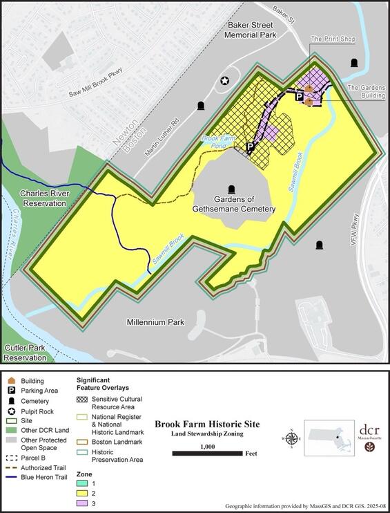
Figure 1. Land Stewardship Zoning Map
DCR Stewardship Map Tool
This RMP should be viewed in conjunction with DCR’s Stewardship Map, a GIS-based tool that allows users to view a property’s natural, cultural, and recreational resources. The Stewardship Map tool is dynamic, and information continues to be updated after adoption of an RMP. Guidance for using the tool, as well as Best Management Practices for resource stewardship, are located on the Stewardship Map site.
Because authorized trails are located within State-Listed Species Habitat on this property, managers should consult an additional GIS-based tool, the NHESP 2022 Guidance Codes for DCR Trail Maintenance Map. This tool allows users to select specific trail segments and identify restrictions and regulatory review associated with performing 10 common trail maintenance activities on these segments. Because site-specific rare species information is confidential under Massachusetts law (M.G.L. c. 66, § 17D), access to this tool is restricted.
Consistency Review
Resource Management Plans “shall ensure consistency between recreation, resource protection, and sustainable forest management” (M.G.L. c. 21, § 2F). For planning purposes, an activity is considered consistent with resource protection if it has no significant, long-term, adverse impact on resources. To this end, a series of indicators were developed to evaluate the impacts of recreation and forest management on natural and cultural resources.
Many activities with the potential to negatively affect resources are already subject to agency and/or regulatory review (e.g., forest management activities, projects within Priority Habitat). For these activities, compliance with state regulations, regulatory authority guidance, DCR policies and processes, and BMPs is considered an indicator of consistency between park use and resource protection. New indicators were generated for activities not subject to agency or regulatory review, and are based on available data, information readily identifiable via aerial imagery or site visits, assessments by DCR subject matter experts, or the property manager’s knowledge of park conditions and use (see Table 18).
Indicators are applied during the RMP planning process to ensure a standardized assessment of consistency across all properties in the DCR system. Inconsistencies identified via the application of indicators are used to inform the development of management recommendations.
The status of indicators (Yes, No, Unknown, and N/A) were accurate at the time this RMP was prepared and were used for planning purposes. However, they represent a snapshot in time and may not reflect future conditions. In addition, the status of indicators will change as recommendations get implemented.
Table 18. Consistency Assessment. This assessment represents a snapshot in time and may not reflect future conditions.
| Category | Metric | Status |
|---|---|---|
| Landscape Designation | 1. All development and uses of the park since 2012, or currently planned for the park, are consistent with its Landscape Designation(s). | Yes |
| Natural Resources | 1. All projects (normal maintenance activities, special projects, volunteer projects) conducted within Priority Habitat were reviewed and approved through DCR’s internal review process and by NHESP for potential impacts to rare species and their habitats. | No |
| Natural Resources | 2. All projects conducted within areas subject to state and/or federal wetlands or waterways regulations were reviewed and approved through DCR’s internal review process; reviewed and approved through the appropriate, local, state, and/or federal review process; and were carried out in accordance with the terms of a valid permit. | No |
| Natural Resources | 3. Sensitive resource areas, such as steep slopes, riverbanks, streambanks, pond and lakeshores, wetlands, and dunes are free of desire paths and other user-created trails. | No |
| Natural Resources | 4. Aquatic areas adjacent to beaches, boat ramps and launches, roads, and hiking trails are free of eroded sediments. | No |
| Natural Resources | 5. The extent of exposed soil in campground and/or picnic sites is stable or decreasing. | N/A |
| Natural Resources | 6. The extent of native vegetation in campground and/or picnic sites is stable or increasing. (As assessed by property manager.) | N/A |
| Natural Resources | 7. Area of trail impacts in Reserves is less than 50% of area. (See Naughton (2021) for information on primary area of trail impacts.) | N/A |
| Natural Resources | 8. Congregations of breeding, migratory, or wintering wildlife are protected from disturbance by temporary (e.g., seasonal) restrictions on recreational access. | N/A |
| Natural Resources | 9. Geocaches, letterboxes, orienteering control locations, and other discovery destinations are located outside sensitive natural resource areas and their locations have been reviewed and approved by park personnel. (As assessed by property manager.) | No |
| Natural Resources | 10. Zone I wellhead protection areas are free of vehicle parking, chemical storage, or concentrated recreation. | N/A |
| Natural Resources | 11. All boat ramps and launches have cleaning stations and/or educational signs and materials on preventing the spread of aquatic invasive organisms. (As assessed by property manager.) | N/A |
| Natural Resources | 12. For each barrier beach there is a current, approved Barrier Beach Management Plan and all beach-related activities are conducted in accordance with this plan. | N/A |
| Cultural Resources | 1. All maintenance activities and projects with the potential to cause sub-surface disturbance are being reviewed by the DCR archaeologist for potential impacts to archaeological resources. | No |
| Cultural Resources | 2. All maintenance activities and projects affecting historic properties (buildings, structures, and landscapes over 50-years-old) are being reviewed by the Office of Cultural Resources to avoid adverse impacts. | Yes |
| Cultural Resources | 3. Historic buildings, structures, and landscapes are being used, maintained, and repaired in a manner that preserves their cultural integrity and conveys their historic significance to park visitors. | No |
| Cultural Resources | 4. Recreational activities such as hiking, biking, and boating are not eroding cultural properties such as archaeological sites or historic landscapes through creation of desire lines, rutting in the landscape, damage to historic built features, or excessive scouring (erosion) of coastal and shoreline areas. | No |
| Cultural Resources | 5. Geocaches, letterboxes, and other discovery destinations are located away from sensitive cultural resources, and their locations have been reviewed and approved by park personnel. | No |
| Cultural Resources | 6. Historic buildings, structures, landscapes, archaeological sites, and concentrations of historic resources are located outside of areas predicted to be subject to flooding, storm surge, or sea-level rise. | No |
| Recreation | 1. Types of recreation, levels of recreational use, and types and extent of recreation infrastructure are consistent with the park’s identity statement. | Yes |
| Recreation | 2. Trail density is consistent with the park’s Landscape Designation(s). (See Trails Guidelines and Best Practices Manual (DCR 2019) for density thresholds.) | Yes |
| Recreation | 3. All authorized trail construction was performed in accordance with an approved Trail Proposal Form. | No |
| Recreation | 4. Over 90% of the park’s official trails network is classified as being in Fair or better condition. | No |
| Recreation | 5. Recurring use by OHVs is restricted to authorized trails. (As assessed by property manager.) | N/A |
| Recreation | 6. There is a high level of compliance with dog leash regulations and policies. (As assessed by property manager.) | No |
| Recreation | 7. Athletic fields are free of recreation-caused impacts (e.g., bare spots) to turf. (As assessed by property manager.) | N/A |
| Recreation | 8. Water-based recreation is consistent with “Uses Attained” designation as identified by the MassDEP in its most current integrated list of waters (e.g., MassDEP 2023); Massachusetts Department of Public Health fish consumption advisories; and/or water quality testing at waterfront areas. | N/A |
| Recreation | 9. Recreation facilities are located outside of areas subject to flooding, storm surge, or sea-level rise. | No |
| Sustainable Forest Management | 1. Forestry activities are consistent with Landscape Designation and associated forestry guidelines. | Yes |
| Sustainable Forest Management | 2. Forestry activities are consistent with current Forest Resource Management Plan. | N/A |
| Sustainable Forest Management | 3. Tree cutting is performed in accordance with an approved cutting plan, if required under the Massachusetts Forest Cutting Practices Act (M.G.L. c. 132, § 40–46). | N/A |
Management Recommendations
Twenty-seven priority management recommendations were developed for this property. They are presented in Table 19. All recommendations are of equal importance and should be implemented as resources allow.
Priority management recommendations derive from Threats, Opportunities, and Consistency Assessment information presented in this RMP. For a recommendation to be considered a priority and listed in the table, it must meet one or more of the criteria listed below. Maintenance and management needs not meeting one or more of these criteria are not included in the table but are identified in the Threats and Opportunities sections.
The following types of recommendations are considered priority:
- Natural resource stewardship and restoration activities consistent with park identity and intended to improve ecological function and connectivity.
- Cultural resource management activities consistent with park identity and intended to prevent the loss of integrity of significant cultural resources.
- Improvements consistent with park identity that are needed to support intended park activities.
- Actions required for regulatory compliance or compliance with legal agreements.
- Activities that prevent or ameliorate threats to the health and safety of park visitors and employees.
- Activities that address inconsistencies among recreation, resource protection, and sustainable forest management, as identified through use of the Consistency Assessment checklist.
Progress toward implementing priority recommendations is tracked using DCR’s Capital Asset Management Information System (CAMIS). The property manager should enter each recommendation listed in Table 19 into CAMIS as a separate work order, noting “*RMP” in the description field. Non-traditional work orders (e.g., volunteer trail work, posting of Massachusetts Department of Public Health (DPH) Fish Consumption Advisory posters, certification of vernal pools) should be closed out by the property manager, once the recommendation has been implemented.
Table 19. Priority Recommendations for Brook Farm Historic Site. All recommendations are of equal importance. When multiple agency parties are responsible for implementing a recommendation, the lead party, or parties, are identified parenthetically in the Implementation column. Property managers should enter these recommendations as work orders in CAMIS to ensure their tracking and implementation.
| Category | Recommendation | Implementation |
|---|---|---|
| Natural Resources | Following appropriate review and permitting, implement the Invasive Plant Management Plan: Boston Region (BSC Group 2017) for aquatic and terrestrial invasive plants. Maintain actions as needed. The management recommendations from the Invasive Plant Management Plan for Brook Farm should be supplemented with the updated locations of target species and recommended management methods provided in the Brook Farm Archaeological Sites Invasive Species Management Plan (Lucas Environmental 2025) within the Archaeological Resources Significant Feature Overlay. (See also related Cultural Resource recommendation below.) | Management Forestry, Office of Natural Resources (Lead), Park Operations, Partner |
| Natural Resources | Rebuild native understory in treated invasives areas with site-appropriate species once invasives are stabilized; develop a plan in accordance with the Secretary of the Interior’s Standards for the Treatment of Historic Properties (Birnbaum and Peters 1996) and include deer protection and long-term monitoring per Lucas Environmental (2025) ISMP. | Office of Cultural Resources (Co-Lead), Office of Natural Resources (Co-Lead), Park Operations (Co-Lead), Partner |
| Natural Resources | Survey, document, and submit documentation to certify potential vernal pools that are in NHESP habitat of MESA-protected vernal pool obligate species, in accordance with DCR (n.d.a) and MassWildlife (2009), as warranted. | Office of Natural Resources (Lead), Volunteers |
| Natural Resources | Prepare a Habitat Management Plan for Brook Farm’s state-listed aquatic species, submit to NHESP for review and approval, and implement. | Contractor, Office of Natural Resources (Lead), Park Operations |
| Natural Resources | Implement climate resilience actions: retain flood storage, stabilize eroded areas, and add nature-based solutions, green infrastructure, and wetland crossings that meet stream continuity and floodplain mitigation standards, etc. | Contractor, Office of Climate Resilience (Co-Lead), Lakes & Ponds Program (Co-Lead), Park Operations |
| Natural Resources | Implement the following priority recommendations from the Level One Tree Assessment (Arbor LLC 2025).
| Contractor, Hazard Tree Program, Office of Cultural Resources, Office of Natural Resources (Co-Lead), Park Operations (Co-Lead), Partner, Volunteer |
| Natural Resources | Develop and implement a cemetery-edge BMP plan related to no-dump zones, spill prevention for mowing, and vegetated screens at drift points. | Office of the General Counsel (Co-Lead), Park Operations (Lead), Partner |
| Natural Resources | Establish training for staff and partners on local, state, and federal regulations pertaining to wetland resources and rare species. | Office of Natural Resources (Lead), Park Operations, Partner |
| Cultural Resources | Establish a formal agreement with The Gardens cemetery, consistent with the 1984 Order of Taking, that identifies appropriate uses of Parcel B and management roles and responsibilities. | Office of the General Counsel (Co-Lead), Park Operations (Co-Lead), Partner |
| Cultural Resources | Contact Temple Emeth and Congregation Beth Hamidrash to discuss the possibility of establishing a formal agreement for access through one or more cemetery properties to ensure that the public has the legal right to travel between Brook Farm and Pulpit Rock. | Land Acquisition and Protection Program (Lead), Office of the General Counsel |
| Cultural Resources | Implement recommendations from the Brook Farm Archaeological Site’s Invasive Species Management Plan (Lucas Environmental 2025) within the Archaeological Resources Significant Feature Overlay. | Management Forestry, Office of Cultural Resources, Office of Natural Resources (Lead), Park Operations, Partner |
| Cultural Resources | Complete boundary survey and establish monuments, where missing, at property boundaries; execute MOUs clarifying access, cleanup, and event parking responsibilities. | Contractor, Office of the General Counsel (Co-Lead), Park Operations (Co-Lead), Partner |
| Cultural Resources | Establish training for staff and partners on local, state, and federal cultural resources regulations. | Office of Cultural Resources (Lead), Park Operations, Partner |
| Cultural Resources | Stabilize the c. 1890 Print Shop (water management, masonry/foundation repairs, pest/moisture control); prepare reuse concept and funding options (Structures North Consulting Engineers, Inc. 2025). | Office of Cultural Resources (Lead), Contractor, Park Operations, Partner |
| Cultural Resources | Develop a unified interpretive plan (Indigenous, Utopian, Civil War/Camp Andrew, Orphanage/Lutheran); integrate with trail nodes and Print Shop. | Interpretive Services (Co-Lead), Office of Cultural Resources (Co-Lead), Park Operations |
| Cultural Resources | Explore options for enhanced research and interpretation of the Camp Andrew area. | Interpretive Services, Park Operations, Partners, Research Office |
| Cultural Resources | Protect stonework, cellar holes, and foundations during vegetation work with hand-tools-only zones and contractor briefings (Kelly and Olson 2022: 119–120). | Contractor, Office of Cultural Resources (Lead), Park Operations, |
| Recreation | Create a comprehensive sign plan that addresses identity, orientation, wayfinding, and resource messaging and interpretation. Include maintaining the existing gateway signage at Baker Street, while adding accessible interpretive signage (Welcome Wayside with map), a kiosk map, refreshed trail blazes (including Blue Heron Trail), and signed links to Millennium Park, DCR parks and Charles River trails. Complementary resources and alternative format materials should be available online to support inclusive and informed visitor experience and best practices. | Interpretive Services (Co-Lead), Park Operations (Lead), Regional Staff |
| Recreation | Update DCR web page and create accessible downloadable map with transportation options, arrival instructions, recommended hikes/points of interests, sensitive-area notes, etiquette (including respectful recreation in a cemetery landscape), and permit contacts. | Interpretive Services (Lead), Park Operations, Web Content Creator |
| Recreation | Create accessible parking and a defined accessible route to key viewpoint(s) and interpretive nodes; coordinate with emergency access. Consider alternative entry point from Baker Street to minimize public/private use conflicts and improve visitor experience. | Interpretive Services, Park Operations (Lead), Regional Staff, Universal Access Program (Co-Lead), |
| Recreation | Increase awareness of leash and park use regulations and enhance enforcement with consistent signage, dog-waste stations, and seasonal ranger/volunteer presence. Develop signage in conjunction with comprehensive sign plan noted above. | Bureau of Ranger Services (Co-Lead), Park Operations (Co-Lead), Volunteers |
| Recreation | Resolve trail-related threats and opportunities identified in this RMP, in accordance with Trails Guidelines and Best Practices (DCR 2019, or update), through the following actions:
| Management Forestry, Office of Cultural Resources, Office of Natural Resources, Park Operations (Co-Lead), Partners, Trails and Greenways Section (Co-Lead) |
| Recreation | Coordinate seasonal volunteer days for trail work, invasive pulls, and post-storm litter removal; track outcomes. | Office of Natural Resources, Park Operations (Lead), Partners, Volunteers |
| Recreation | As appropriate, promote EEA’s Environmental Justice Policy goals at Brook Farm Historic Site. | Interpretive Services (Co-Lead), Park Operations (Co-Lead), Partners |
| Recreation | Resolve existing encroachments at Brook Farm in accordance with Agency-wide guidance and Best Management Practices (DCR 2022b). | Contractor, Management Forestry, Office of the General Counsel, Park Operations, Regional Staff (Lead) |
| Recreation | Work with the geocaching community to ensure that caches located in sensitive natural and cultural resources are relocated out of those areas and that locations of any new geocaches are placed outside of sensitive areas and with the approval of the property manager. | Office of Cultural Resources, Office of Natural Resources, Park Operations (Lead) |
| Recreation | Work with the City of Boston to identify ways to improve safety along Baker Street near the Park entrance. | Transportation, Infrastructure, and Construction (Lead), Partner |
References
Plans and Guiding Documents
Allen & Major Associates. 2025. Brook Farm Historic Site: Existing conditions, S-3544-01-EC. Prepared for the Massachusetts Department of Conservation and Recreation. December 4, 2025.
Arbor LLC. 2025. Brook Farm Historic Site: Level One Tree Assessment. Fitzwilliam, NH: Arbor LLC. Prepared for Ray Dunetz Landscape Architecture (RDLA), September 25, 2025.
Boston Landmarks Commission. 1977. Report of the Boston Landmarks Commission on the potential designation of Brook Farm as a Landmark under Chapter 722 of the Acts of 1975. Boston: Boston Landmarks Commission, 1977.
BSC Group, Inc. (BSC). 2017. Invasive Plant Management Plan: Boston Region. Produced in association with: DCR Ecology & ACEC Program, June 2017.
Cavanaugh, J., M. Dewart, and J. Stoessel. 1990. A pastoral vision reclaimed: A preliminary master plan for Brook Farm Historic Site. An M.D.C. Reservation, West Roxbury, Massachusetts.
Fleetwood, C. 2026. Re: Brook Farm / Baker St – Boston. E-mail to J. Santos, April 15, 2026. With attachment.
Gregory, P. 2025. Brook Farm encroachments: November 25, 2025. Unpublished report.
Halverson Design Partnerships. 2006. Park improvements and cost study. West Roxbury District. June 2006.
Kelly, J. M., and H. L. Olson. 2022. Archaeological overview and planning assessment: Brook Farm Historic Site, West Roxbury, Boston, Massachusetts. Pawtucket, RI: The Public Archaeology Laboratory, Inc., [2022]. Unpublished technical report submitted to the Massachusetts Department of Conservation and Recreation.
Lucas Environmental, LLC. 2025. Invasive Species Management Plan, Brook Farm Historic Site, West Roxbury, Massachusetts. Prepared for the Massachusetts Department of Conservation and Recreation, October 17, 2025.
Massachusetts Department of Conservation and Recreation (DCR). 2012a. Landscape Designations for DCR Parks and Forests: Selection Criteria and Management Guidelines. March 2012
Massachusetts Department of Conservation and Recreation (DCR). 2012b. Appendix 4. Land Stewardship Zoning Guidelines. Final Update: July 2012. Pages 76–85 In Landscape Designations for DCR Parks and Forests: Selection Criteria and Management Guidelines. March 2012.
Massachusetts General Court (MGC). 1973. Chapter 1225 of the Acts of 1973. An Act directing the Metropolitan District Commission to acquire certain real property in the West Roxbury Section of the City of Boston.
Massachusetts. General Court (MGC). 2008. Chapter 0302 of the Acts of 2008. An Act making appropriations for the Fiscal Year 2008 to provide for supplementing certain existing appropriations and for certain other activities and projects
Metropolitan District Commission (MDC). 1993. Brook Farm Historic Site, draft project and management initiatives.
Pendery, S. R., and R. W. Preucel. 1992. The archaeology of social reform: Report on the 1990 and 1991 field seasons of the Brook Farm Hive archaeology project. Submitted to the Massachusetts Historical Commission.
Preucel, R. W., and S. R. Pendery. 2006. Envisioning Utopia: Transcendentalist and Fourierist landscapes at Brook Farm, West Roxbury, Massachusetts. Historical Archaeology, 40(1): 6–19, Daring experiments: Issues and insights about Utopian communities.
Rettig, P. M. 1976. Brook Farm. National Register of Historic Places Inventory – Nomination Form. April 3, 1976.
Schultz, K. H. 1988. Life at Brook Farm: A framework for interpretation. Cultural Resource Management Study Series Vol. 4a. Metropolitan District Commission, Boston, MA.
Structures North Consulting Engineers, Inc. 2025. Brook Farm Print Shop Structural Conditions Report, DRAFT (September 15, 2025). Prepared for Ray Dunetz Landscape Architecture.
Additional Information
AECOM. 2013. The impact of climate change and population growth on the National Flood Insurance Program through 2100. Prepared for Federal Insurance and Mitigation Administration and Federal Emergency Management Agency.
Askew, A. E., and J. M. Bowker. 2018. Impacts of Climate change on outdoor recreation participation: Outlook to 2060. Journal of Park and Recreation Administration 36: 97–120.
Birnbaum, C. A., and C. C. Peters. (Eds.) 1996. The Secretary of the Interior’s standards for the treatment of historic properties with guidelines for the treatment of cultural landscapes. U.S. Department of the Interior, National Park Service, Cultural Resource Stewardship and Partnerships, Heritage Preservation Services, Historic Landscape Initiative, Washington, DC.
Cartwright, J., T. L. Morelli, and E. H. Campbell Grant. 2022. Identifying climate-resistant vernal pools: Hydrologic refugia for amphibian reproduction under droughts and climate change. Ecohydrology 2022, 15, e2354.
Commonwealth of Massachusetts. 2023. ResilientMass Plan: 2023 Massachusetts State Hazard Mitigation and Climate Adaptation Plan. ResilientMass Action Team, Boston, Massachusetts.
Cullina, M. D., B. Connolly, B. Sorrie, and P. Somers. 2011. The vascular plants of Massachusetts: A county checklist. First revision.
Drake, F. S. 1878. The Town of Roxbury: Its Memorable Persons and Places, Its History and Antiquities, with Numerous Illustrations of its Old Landmarks and Noted Personages. Francis S. Drake, Roxbury, MA.
Dukes, J. S., J. Pontius, D. Orwig, J. R. Garnas, V. L. Rodgers, N. Brazee, B. Cooke, K. A Theoharides, E. E. Stange, R. Harrington, J. Ehrenfeld, J. Gurevitch, M. Lerdau, K. Stinson, R. Wick, and M. Ayres. 2009. Responses of insect pests, pathogens, and invasive plant species to climate change in the forests of northeastern North America: What can we predict? Canadian Journal of Forest Research 39: 231-248.
Finch, D. M., J. L. Bitler, J. B. Runyon, C. J. Fettig, F. F. Kilkenny, S. Jose, S. J. Frankel, S. A. Cushman, R. C. Cobb, J. S. Dukes, J. A. Hicke, and S. K. Amelon. 2021. Effects of Climate Change on invasive species. Chapter 4 in T. M. Poland, T. Patel-Weynand, D. M. Finch, C. F. Miniat, D. C. Hayes, and V. M. Lopes (Editors) Invasive species in forests and rangelands of the United States: A comprehensive science synthesis for the United States forest sector. Springer.
Friggens, M. M., M. I. Williams, K. E. Bagne, T. T. Wixom, and S. A. Cushman. 2018. Effects of climate change on terrestrial animals. Pages 264–315 in Halofsky, J. E., D. L. Peterson, J. J. Ho, N. J. Little, and L. A. Joyce (Eds.). Climate change vulnerability and adaptation in the Intermountain Region. Gen. Tech. Rep. RMRS-GTR-375. Fort Collins, CO: U.S. Department of Agriculture, Forest Service, Rocky Mountain Research Station. Part 2. pp. 199–513.
Gordon, G. H. 1883. Brook Farm to Cedar Mountain in the War of the Great Rebellion, 1861–62. J. R. Osgood and Company, Boston, MA.
Grimmer, A. E. 2017. The Secretary of the Interior’s standards for the treatment of historic properties with guidelines for preserving, rehabilitating, restoring & reconstructing historic buildings. Revised by Anne E. Grimmer from The Secretary of the Interior’s standards for treatment of historic properties with guidelines for preserving, rehabilitating, restoring & reconstructing historic buildings. Kay D. Weeks and Anne E. Grimmer (1995).
Halofsky, J. E., D. L. Peterson, J. J. Ho, N. J. Little, and L. A. Joyce (Eds.). 2018. Climate change vulnerability and adaptation in the Intermountain Region. Gen. Tech. Rep. RMRS-GTR-375. Fort Collins, CO: U.S. Department of Agriculture, Forest Service, Rocky Mountain Research Station. Part 2. pp. 199–513.
Ham, S. H. 2013. Interpretation: Making a difference on purpose. Fulcrum Publishing, Golden, CO.
Intergovernmental Panel on Climate Change (IPCC). 2021. Annex VII: Glossary [Matthews, J.B.R., V. Möller, R. van Diemen, J.S. Fuglestvedt, V. Masson-Delmotte, C. Méndez, S. Semenov, A. Reisinger (eds.)]. In Climate Change 2021: The Physical Science Basis. Contribution of Working Group I to the Sixth Assessment Report of the Intergovernmental Panel on Climate Change [Masson-Delmotte, V., P. Zhai, A. Pirani, S.L. Connors, C. Péan, S. Berger, N. Caud, Y. Chen, L. Goldfarb, M.I. Gomis, M. Huang, K. Leitzell, E. Lonnoy, J.B.R. Matthews, T.K. Maycock, T. Waterfield, O. Yelekçi, R. Yu, and B. Zhou (eds.)]. Cambridge University Press, Cambridge, United Kingdom and New York, NY, USA, pp. 2215–2256, doi:10.1017/9781009157896.022.
International Council on Monuments and Sites (ICOMOS) Climate Change and Cultural Heritage Working Group. 2019. The Future of our Pasts: Engaging Cultural Heritage in Climate Action. ICOMOS, Paris, France.
Isaak, D. J., M. K. Young, C. Tait, D. Duffield, D. L. Horan, D. E. Nagel, and M. C. Groce. 2018. Effects of climate change on native fish and other aquatic species. Pages 89–111 in Halofsky, J. E., D. L. Peterson, J. J. Ho, N. J. Little, and L. A. Joyce (Eds.). Climate change vulnerability and adaptation in the Intermountain Region. Gen. Tech. Rep. RMRS-GTR-375. Fort Collins, CO: U.S. Department of Agriculture, Forest Service, Rocky Mountain Research Station. Part 1. Pp. 1–197.
Janowiak, M. K., A. W. D’Amato, C. W. Swanston, L. Iverson, F. R. Thompson, III, W. D. Dijak, S. Matthews, M. P. Peters, A. Prasad, J. S. Fraser, L. A. Brandt, M. J. Butler-Leopold, S. D. Handler, P. D. Shannon, D. Burbank, J. Campbell, C. Cogbill, M. J. Duveneck, M. R. Emery, N. Fisichelli, J. Foster, J. Hushaw, L. Kenefic, A. Mahaffey, T. L. Morelli, N. J. Reo, P. G. Schaberg, K. R. Simmons, A. Weiskittel, S. Wilmot, D. Hollinger, E. Lane, L. Rustad, and P. H. Templer. 2018. New England and northern New York ecosystem vulnerability assessment and synthesis: A report from the New England Climate Change Response Framework project. Gen. Tech. Rep.NRS-173. Newtown Square, PA: U.S. Department of Agriculture, Forest Service, Northern Research Station. 234 p.
Kliejunas, J. T., B. W. Geils, J. M. Glaeser, E. M. Goheen, P. Hennon, M.-S. Kim, H. Kope, J. Stone, R. Sturrock, and S. J. Frankel. 2009. Review of literature on climate change and forest diseases of western North America. Gen. Tech. Rep. PSW-GTR-225. Albany, CA: U.S. Department of Agriculture, Forest Service, Pacific Southwest Station.
Leddick, J. 2026. RE: Draft Brook Farm Historic Site Resource Management Plan. Letter to P. Cavanagh, Massachusetts Department of Conservation and Recreation, from Massachusetts Division of Fisheries and Wildlife. January 20, 2026.
Liu, Y., A. M. O. Odour, Z. Zhang, A. Manea, I. M. Tooth, M. R. Leishman, X. Xu, and M. Van Kleunen. 2017. Do invasive alien plants benefit more from global environmental change than native plants? Global Change Biology (2017), doi: 10.1111/gcb.13579.
Lopenzina, D. 2006. Red ink: Native Americans picking up the pen in the colonial period. Doctoral Dissertations 323. University of New Hampshire, Durham.
Massachusetts Bureau of Geographic Information (MassGIS). 2025. FEMA National Flood Hazard Layer. July 2025.
Massachusetts Department of Conservation and Recreation (DCR). n.d.a. Best Management Practices for Woodland Trail Maintenance. Office of Regional Planning, Boston, MA.
Massachusetts Department of Conservation and Recreation (DCR). n.d.b. Best Management Practices: Vernal pool certification on DCR lands. Office of Regional Planning, Boston, MA.
Massachusetts Department of Conservation and Recreation (DCR). 2019. Trails guidelines and best practices manual. Updated July 2019.
Massachusetts Department of Conservation and Recreation (DCR). 2020. Massachusetts State Forest Action Plan 2020. Executive Office of Energy & Environmental Affairs, Department of Conservation and Recreation, Massachusetts Bureau of Forest Fire Control and Forestry.
Massachusetts Department of Conservation and Recreation (DCR). 2022a. Manual for Continuous Forest Inventory field procedures. Bureau of Forestry, Division of State Parks and Recreation. Rev. March 2022.
Massachusetts Department of Conservation and Recreation (DCR). 2022b. Encroachments. Massachusetts Department of Conservation and Recreation, Agency-wide guidance and best management practices. Version 1.1 Approved BMP, 011922.
Massachusetts Department of Conservation and Recreation (DCR). 2023. Managing our forests…for carbon benefits.
Massachusetts Department of Conservation and Recreation (DCR). 2024. DCR Climate Impacts. Story Map series highlighting the expected impacts caused by climate change across the DCR’s facilities and operations in Massachusetts.
Massachusetts Department of Environmental Protection (MassDEP). 2023. Final Massachusetts integrated list of waters for the Clean Water Act 2022 Reporting Cycle. CN. 568.1. May 2023. Prepared by: Watershed Planning Program, Division of Watershed Management, Bureau of Water Resources.
Massachusetts Division of Fisheries and Wildlife (MassWildlife) 2009. Guidelines for the certification of vernal pool habitat, March 2009.
Massachusetts Division of Fisheries and Wildlife (MassWildlife). 2015. Massachusetts State Wildlife Action Plan 2015. Westborough, MA.
Massachusetts Executive Office of Energy and Environmental Affairs (EEA). 2021. Environmental Justice Policy of the Executive Office of Energy and Environmental Affairs. Updated June 24, 2021.
Massachusetts Executive Office of Energy and Environmental Affairs (EEA). 2022a. 2022 Massachusetts Climate Change Assessment, Volume II – Statewide Report. Executive Office of Energy and Environmental Affairs, Boston, MA.
Massachusetts Executive Office of Energy and Environmental Affairs (EEA). 2022b. Massachusetts Climate and Hydrologic Risk Project (Phase 1) – Stochastic Weather Generator Climate Projections Data. Downscaled temperature and precipitation projections for Massachusetts under high emissions scenarios for 2030, 2050, 2070 and 2090. December 12, 2022.
Massachusetts Executive Office of Energy and Environmental Affairs (EEA). 2024. Environmental Justice Strategy. Secretariat and agency strategies for proactively promoting environmental justice in the Commonwealth of Massachusetts. February 2024.
Massachusetts Historical Commission (MHC). 1981. Town Reconnaissance Survey Report: Roxbury/West Roxbury. Boston, MA.
Massachusetts Historical Commission (MHC). 1982. Historic and Archaeological Resources of the Boston Area: A Framework for Preservation Decisions. Boston, MA.
Massachusetts Invasive Plant Advisory Group (MIPAG). 2025. Species reviewed (listed by category) – Last updated 3/2025.
McNab, W. H., and D. L. Loftis. 2002. Probability of occurrence and habitat features for oriental bittersweet in an oak forest in the southern Appalachian Mountains, USA. Forest Ecology and Management 155(2002): 45–54.
Merow, C., S. T. Bois, J. N. Allen, Y. Xie, and J. A. Silander, Jr. 2017. Climate change both facilitates and inhibits invasive plant ranges in New England. Proceedings of the National Academy of Sciences E3276–E3284.
National Park Service (NPS). 1998. Planning for interpretation and visitor experience. Prepared by the Division of Interpretive Planning, Harpers Ferry Center, Harpers Ferry, WV.
Naughton, M. 2021. Wildlife & recreation: Understanding and managing the effects of trail use on wildlife. Prepared for Vermont Fish and Wildlife and Vermont Forests, Parks, and Recreation. November 2021.
O’Toole, D., L. A. Brandt, M. K. Janowiak, K. M. Schmitt, P. D. Shannon, P. R. Leopold, S.D. Handler, T. A. Ontl, and C. W. Swanston. 2019. Climate adaptation strategies and approaches for outdoor recreation. Sustainability 2019, 11, 7030.
Patrick, D. L. 2014. Executive Order No. 552. Executive Order on Environmental Justice. 11/25/2014.
Rockman, M., M. Morgan, S. Ziaja, G. Hambrecht, and A. Meadow. 2016. Cultural Resources Climate Change Strategy. National Park Service, Cultural Resources, Partnerships, and Science and Climate Change Response Program, Washington, D.C.
Rustad, L., J. Campbell, J. S. Dukes, T. Huntington, K, F. Lambert, J. Mohan, and N. Rodenhouse. 2012. Changing climate, changing forests: The impacts of climate change on forests of the northeastern United States and eastern Canada. Gen. Tech. Rep. NRS-99. Newtown Square, PA: U.S. Department of Agriculture, Forest Service, Northern Research Station.
Sasek, T. W., and B. R. Strain. 1990. Implications of atmospheric CO2 enrichment and climate change for the geographical distribution of two introduced vines in the U.S.A. Climatic Change 16: 31–51.
Sturrock, R. N., S. J. Frankel, A. V. Brown, P. E. Hennon, J. T. Kliejunas, K. J. Lewis, J. J. Worrall, and A. J. Woods. 2011. Climate change and forest disease. Plant Pathology (2011) 60, 133–149.
Swanston, C. W., M. K. Janowiak, L. A. Brandt, P. R. Butler, S. D. Handler, P. D. Shannon, A. Derby Lewis, K. Hall, R. T. Fahey, L. Scott, A. Kerber, J. W. Miesbauer, L. Darling, L. Parker, and M. St. Pierre. 2016. Forest adaptation resources: Climate change tools and approaches for land managers, 2nd ed. Gen. Tech. Rep. NRS-GTR-87-2. U.S. Department of Agriculture, Forest Service, Northeast Research Station. Newtown Square, PA.
United Nations Educational, Scientific and Cultural Organization (UNESCO) World Heritage Center. 2007. Climate Change and World Heritage. Report on predicting and managing the impacts of climate change on World Heritage and strategy to assist States parties to implement appropriate management responses. World Heritage Reports 22. UNESCO World Heritage Center, Paris, France.
VHB. 2022. DCR Stormwater Design Handbook. October 19, 2022. Prepared for the Massachusetts Department of Conservation and Recreation.
Weston and Sampson. 2022. Climate change vulnerability assessment. September 2022. Report prepared for Massachusetts Department of Conservation and Recreation.
Wilkins, E. J., and L. Horne. 2024. Effects and perceptions of weather, climate, and climate change on outdoor recreation and nature-based tourism in the United States: A systematic review. PLOS Climate 3(4): e0000266.
Wobus, C., E. E. Small, H. Hosterman, D. Mills, M. Rissing, R. Jones, M. Duckworth, R. Hall, J. Creason, and J. Martinich. 2017. Projected climate change impacts on skiing and snowmobiling in the United States. Global Environmental Change. 45(2017) 1–14.
Appendices
Appendix A – Chapter 1225 of the Acts of 1973 (MGC 1973)
Chap. 1225. An Act Directing the Metropolitan District Commission to Acquire Certain Real Property in the West Roxbury Section of the City of Boston.
Be it enacted, etc., as follows:
SECTION 1. The metropolitan district commission is hereby authorized and directed to acquire for conservation, natural water storage of flood waters, historic, scenic and passive recreational purposes, approximately one hundred and seventy-nine acres of land adjacent to the Charles river in the West Roxbury section of the city of Boston, known as the Sawmill Brook .valley and Brook farm.
Said property, currently owned by the Lutheran Service Organization of New England, Inc., is described in a deed given by Lauraria E. Munae to Gottlieb F. Burkhardt dated the eighth day of December, eighteen hundred and seventy and recorded at the registry of deeds, Norfolk County, Book 401, page 98, which deed contains a complete description of the property.
SECTION 2. The metropolitan district commission shall also acquire a pedestrian right-of-way from the area known as Brook farm to the Memorial reservation known as John Elliot's Pulpit Rock, property of the Roxbury Historical Society. Said commission is hereby authorized to negotiate with the Holyhood Cemetery Association for access from the Sawmill Brook valley to the Veterans of Foreign Wars parkway owned by the commission, and may enter into an agreement, approved as to form by the attorney general, to exchange land for said purpose.
SECTION 3. The existing cemetery area, Gethsemane Cemetery, so-called, consisting of approximately fifteen acres shall be excluded from the acquisition. For maintenance of perpetual care purposes an additional maximum of fifteen acres of cemetery land currently under cemetery permit but as not yet developed for cemetery use may be also excluded from the acquisition. Various support facilities essential to cemetery operation shall also be excluded from the acquisition. Appropriate right-of-ways shall be provided for cemetery use.
SECTION 4. To meet the expenditures necessary in carrying out the provisions of section one, the state treasurer shall, upon request of the governor, issue and sell at public or private sale bonds of the commonwealth, registered or with interest coupons attached, as he may deem best, to an amount specified by the governor from time to time, but not exceeding, in the aggregate, the sum of two million two hundred thousand dollars. All bonds issued by the commonwealth, as aforesaid, shall be designated on their face, Sawmill Brook Valley and Brook Farm Conservation Loan, Act of 1973, and shall be on the serial payment plan for such maximum term of years, not exceeding twenty years, as the governor may recommend to the general court pursuant to Section 3 of Article LXII of the Amendments to the Constitution of the Commonwealth, the maturities thereof to be so arranged that the amounts payable in the several years of the period of amortization, other than the final year, shall be as nearly equal as in the opinion of the state treasurer it is practicable to make them. Said bonds shall bear interest semiannually at such rate as the state treasurer, with the approval of the governor, shall fix. The initial maturities of such bonds shall be payable not later than one year from the date of issue thereof and the entire issue not later than June thirtieth, nineteen hundred and ninety-nine. All interest payments and payments on account of principal of such bonds shall be paid from the Metropolitan Parks District Fund to be assessed by methods fixed by law.
SECTION 5. The metropolitan district commission is hereby authorized to accept funds from public and private sources and may make application for federal and state assistance in carrying out the projects authorized by this act. Any such funds or assistance made available to the metropolitan district commission for the projects authorized by this act shall, if the bonds have not been sold; be used to reduce the amount of the bonds so authorized, and if the bonds have been sold, said funds or assistance when received shall be used to meet the payment of maturities and interest on the bonds issued under this act.
SECTION 6. No expenditure shall be made from funds authorized by this act for consultant services, so called, or services coded in accordance with the expenditure code manual under the subsidiary title. "03 Services - Nonemployees" unless the rate of compensation for such services shall have been approved by the commissioner of administration. Said commissioner shall, immediately upon the approval of any such rate or rates, file copies of the schedule or schedules of approved rates with the comptroller and with the house and senate committees on ways and means. Before engaging such consultant services undersaid subsidiary title ''03", as so coded, as "Professional," the department shall certify to the budget director that funds are available for the purpose and shall then file a statement of intent with the budget director, the comptroller, and the house and senate committees on ways and means. Such statement shall include the rate of compensation, the period of time for which the services are to be engaged or scope of work to be done, and such other pertinent information as may be necessary to establish the maximum limit of the commonwealth's obligation.
SECTION 7. Any land or land with buildings thereon for the acquisition of which an appropriation is made in this act shall be acquired by purchase or by eminent domain under chapter seventynine of the General Laws; provided, that no payment shall be made for the purchase of any such property until at least one independent appraisal of the value thereof has been made by a qualified disinterested appraiser; and, provided further, that the cost of such appraisal or appraisals shall be charged to said item of appropriation.
Approved December 12, 1973.
Appendix B – Land Taking Plan. Boston, Massachusetts. August 3, 1993. See Suffolk County Registry of Deeds Book 15055 Page 329 For the associated Order of Taking.
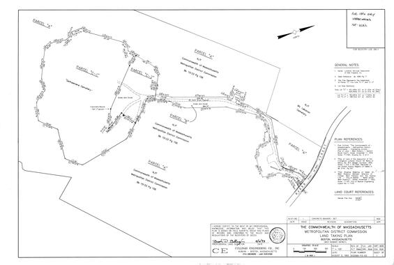
| Date published: | June 15, 2026 |
|---|