Location listing filters
Map for Douglas State Forest
Note for screen reader users, we suggest skip the following interactive map and go to the location listing for a better user experience.
Currently, the map is not accessible yet for a comprehensive experience.
skip to the location listing
Location Listing
Showing 1 - 2 of 2 results for Other locations related to Douglas State Forest
-
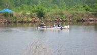
Blackstone River and Canal Heritage State Park
- Wheelchair Accessible
287 Oak St. , Uxbridge, MA 01569 DirectionsThe Blackstone River features 1000 acres of natural park, filled with trails and historical sites. The park also has biking, horseback riding, canoe access, fishing, hunting, picnic areas and more.
The story of River Bend Farm in Uxbridge, MA serves as an example of the story of many farms in the Blackstone Valley. Located about half way between Providence, Rhode Island and Worcester, Massachusetts, River Bend Farm sits at the crossroads of agricultural life, mill villages, transportation routes, and developing town centers. River Bend Farm represents the changing landscape over the last four centuries.
There are fields, open pastures, stone walls, and preserved historical sites that bear witness to a farming past in a valley that witnessed the birth of an industrial revolution.
River Bend Farm today stands as a reminder of the Valley’s long agrarian past. Indeed, glimpses of the Valley’s heritage are evident throughout the region. The landscape tells the story of how everyday life changed with succeeding generations – and how it continues to change today.Phone(508) 278-7604-
Sunrise to sunset
-
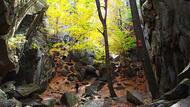
Purgatory Chasm State Reservation
- Wheelchair Accessible
198 Purgatory Rd. , Sutton, MA 01590 DirectionsPurgatory Chasm is a unique natural landmark offering exciting adventure. Follow trails to rock formations such as The Corn Crib, The Coffin and Lovers’ Leap. After exploration, settle down for an afternoon picnic.Phone(508) 234-3733-
Sunrise to sunset