Location listing filters
Map for Natural Bridge State Park
Note for screen reader users, we suggest skip the following interactive map and go to the location listing for a better user experience.
Currently, the map is not accessible yet for a comprehensive experience.
skip to the location listing
Location Listing
Showing 1 - 4 of 4 results for Other locations related to Natural Bridge State Park
-

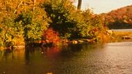
Clarksburg State Park
- Wheelchair Accessible
1199 Middle Rd, Clarksburg, MA 01247 DirectionsClarksburg State Park offers 368 acres of abundant northern hardwood forest. Come camp along the edge of Mausert’s Pond, hike the Pond Loop trail, picnic under the tall pines or enjoy the views. If you are lucky enough you may catch a glimpse of a moose or an otter.Phone(413) 664-8345-
Sunrise to one half-hour after sunset
-
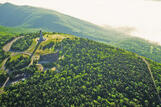
Mount Greylock State Reservation
- Wheelchair Accessible
30 Rockwell Road, Lanesborough, MA 01237 DirectionsAt 3,491 feet, Mount Greylock is the highest point in Massachusetts. From its peak on a clear day, you can see as far as 90 miles away. No matter when you visit, there's plenty to do and see.Phone(413) 499-4262-
Park is open dawn to dusk
-
Savoy Mountain State Forest
- Wheelchair Accessible
260 Central Shaft Road, Florida, MA 01247 DirectionsSavoy Mountain State Forest offers more than 50 miles of trails. You can also camp at one our tent sites, or reserve a log cabin.Phone(413) 663-8469-
Sunrise to sunset
-
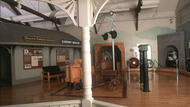
Western Gateway Heritage State Park
- Wheelchair Accessible
9 Furnace St., Building 4, North Adams, MA 01247 DirectionsVisitors to this former railroad yard in North Adams, MA will learn about the controversial and dangerous construction of the Hoosac Tunnel, which spanned 1851-1875. 200 people were killed while building this 4.75-mile tunnel. Visitors can see historical artifacts and exhibits to better understand this historic engineering feat.
Phone(413) 663-6312-
Temporarily closed