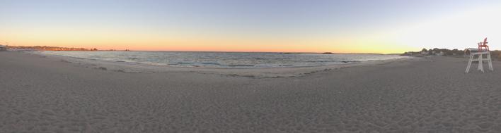
The coastal beach with the constant movement of winds and waves is a fascinating—and sometimes even baffling—place. Where does all the sand, rock, and other sediment come from? Why does the beach shift from season to season? Why does the sand sometimes squeak or sparkle? Shiver me timbers, is this a plank from a pirate ship, a piece of driftwood, or an ancient coastal tree stump? This tip will help answer questions like these so you can identify and understand more about the beach, discover clues to its history and how it was formed, and much more. And if you are curious about beach flora and fauna too, check out CZ-Tip - Identifying Animals and Plants on the Massachusetts Coast.
The Source of Beach Sand and Sediments
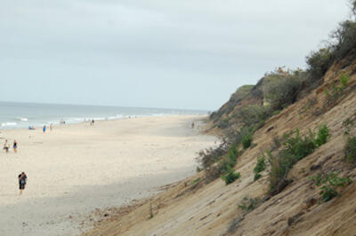
In Massachusetts, coastal beaches are mostly made up of rock materials that have been weathered and broken down by water, ice, weather, glaciers, and chemical reactions, and then transported to the shore. The source of this sand and other sediment is primarily nearby coastal banks or bluffs, but some sediments are carried by streams and rivers from inland areas to the ocean. Once at the seashore, these materials—ranging from boulders to pebbles to sand—are subject to almost continuous movement. The waves, tides, and currents shift and move the material along the coast and back and forth between the beaches and nearshore areas (the areas underwater but near the shore). Wind also plays a big part in carrying and sorting sand along the shore by picking up the finer-grained particles and blowing them toward the dunes, leaving heavier larger grains behind on the beach. For information on how the Cape Cod shores were formed from glacial times to today, see the U.S. Geological Survey (USGS) Cape Cod and the Sea web page. For more information on the origins of a beach, see the National Park Service’s (NPS) web page on Coastal Sediments—Parent Material and Science of Summer: Where Does Beach Sand Come From? from LiveScience.com.
The Shifting Shoreline
On a daily basis, sand and sediments are moved along the shore, onto beaches and dunes, or out to sea by wind, waves, and tides. Beaches also change seasonally—gradually growing during the summer months when low energy waves deposit sediments on the beach (making a flatter beach) and eroding dramatically during the winter when high energy storm waves move sediments to the lower beach or nearshore (making a steeper beach). When sediments erode, they are not necessarily “lost” to the sea—they typically form sandbars in the nearshore area and provide a source of sediment for the rebuilding of the beaches and dunes when calmer waves prevail. In some cases, however, sediments may be lost permanently when they are taken way out to sea in severe storms. In addition, seawalls, rock revetments, or other “hard” shoreline stabilization structures impede the natural supply of sand, which can cause erosion in down-drift areas of the beach system. Sea level rise can also play a part in beach loss. For additional information on shoreline and beach dynamics, see the following websites:
- CZM's Shoreline Change Project illustrates how the shoreline of Massachusetts has shifted between the mid-1800s and 2009, complete with interactive maps and information on how and why this change happens.
- Barnstable County Cape Cod Cooperative Extension’s Shifting Shorelines website offers virtual tours of Cape Cod’s sediment transport along its various shorelines.
- The Science of the Shore—A Tale of Two Beaches: Winter & Summer Beach Profiles page by Friends of Island Beach State Park depicts the seasonal changes to beaches and dunes as a result of erosion and accretion.
- The Sand Movement page on the Explore Beaches website from the University of California and California Sea Grant provides graphics and explanations of the way sand moves, collects, and erodes along the coast.
- Stone Living Lab and the University of Massachusetts Boston’s Beach Profiling Story Map provides photos, diagrams, and information about coastal processes and dynamics, the Emery Method used to profile beaches, and profiling results at a number of Boston beaches.
Beach Composition and Colors
In Massachusetts, the beach sand is primarily made up of small grains of the mineral quartz, which comes from many different types of rocks. Quartz is abundant because it is hard, insoluble in water, and doesn't break down easily from the weathering processes. Feldspar, though slightly softer than quartz, is another mineral commonly found on the beach. Since quartz and feldspar are generally light in color, the overall color of Massachusetts beaches ranges from white to tan to gray. However, the presence of other minerals may also influence the look of the beach. For instance, certain beaches on Plum Island may appear purple because they contain a high presence of the mineral garnet. Crane Beach also looks purple, particularly in the winter when the lighter quartz and feldspar get eroded away by storm waves and leave the heavier garnet behind (see Historic Ipswich’s Crane Beach page for details). One mineral that can give the beach a sparkly appearance is mica. Mica flakes are light and flat, allowing them to sit on top of the beach and catch the light. To learn more about the color and type of beach sediments along U.S. beaches, see NPS’s Coastal Sediments—Sand Colors page. To learn more about the composition of sand grains, see Sandatlas.org’s What is sand made of page. To see a gallery of interesting and colorful sand grains from around the world (including Plum Island), visit Geology.com’s A Grain of Sand Picture Gallery.
Squeaky Sand
Some beaches make unusual noises when you walk on them. These sounds, known as singing, barking, or whistling, may be caused by an abundance of similarly sized, nearly spherical grains of quartz sand on the beach (without much dust or organic matter between the grains). Walking over this material is thought to cause a vibration as the layers of sand grains slide over each other. You are more apt to hear singing sand on the dry upper portion of the beach because these grains don’t stick together like wet sand. Interested in hearing this for yourself? Singing Beach in Manchester-by-the-Sea is actually named for this phenomenon. For more on singing sand, see How to Read a North Carolina Beach from Coastal Care.
Humps, Lumps, and Other Interesting Beach Bumps
Not unlike an ephemeral sand castle, interesting beach features and forms are constantly being made and destroyed by waves and swash (the sheet of water that washes up and down the beach, carrying sediments with it). The changing beachscape may include:
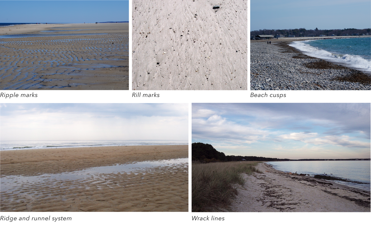
- Ripple marks - Looking like ridges on a potato chip, these marks form a series of low ridges of sand that line up in a linear pattern in the area between high and low tides. Ripple marks can also be formed by the wind. See the How to Read a North Carolina Beach website for more information on ripple marks.
- Rill marks - Carved out by water draining out of the beach at low tide, these miniature erosional channels or braided streams can be seen crossing the beach down to the sea.
- Beach cusps - These wavy and undulating features are a series of evenly spaced mounds or ridges called horns separated by crescent-shaped troughs called embayments. See Coastal Care’s Beach Cusps: Shoreline Symmetry web page for more on how they form and what they mean.
- Ridge and runnel systems - These features characterized by a sand bar (i.e., ridge) seaward of a shallow trough (i.e., runnel) can either be located on the beach (where they form those pools that children love to play in) or in the nearshore area (where they form the sand bars that swimmers can rest on). See the Landforms of Deposition page from A Level Geography for photographs.
- Wrack lines - These piles of debris (including seaweed, seeds, other plant material, driftwood, and man-made objects) are left behind at the uppermost limit of the wave swash. Multiple wrack lines can occur from normal high tides, spring tides, and/or big storms. See CZM’s Managing Seaweed Accumulation on Recreational Beaches (PDF, 2 MB) for information about the importance of wrack lines.
Sea Foam
No, that white sudsy mess is not soap or sludge. The sea foam that appears at the shore is actually a natural occurrence that is typically not harmful to you or the environment (though you may want to take caution with foams that have a weird odor since these may not be “typical”). Natural sea foam forms by waves churning up organic matter (from seaweeds, algae, and other marine plant life). The organic material acts like a surfactant (just like soap) and creates bubbles when agitated. Sometimes, a thin coating of mud attaches to the bubbles, leaving a film of gray behind on the sand. For more on this froth-forming phenomenon, see the National Oceanic and Atmospheric Administration What is sea foam? page and What Is Sea Foam? Where Does It Come From? from Popular Science.
Glimpses into the Past
Given the ability of the shore to shift and move on a daily and seasonal basis, as well as from storms, it is no wonder that interesting finds may literally be uncovered at any time. These items, such as a fossilized tooth or bone fragment from a prehistoric animal or a tree stump from an ancient coastal forest, are evidence of what once existed at these sites. For more information on the ancient discoveries at the beach, see the Woods Hole Sea Grant Program and Cape Cod Cooperative Extension’s What is that sticking out of the sand? The following are a few indicators of remnants of past landscapes and life.
- A mat of peat (the organic material consisting of partly decayed plant matter that accumulates in wet environments) found on the beach after a storm may be evidence that an ancient fresh or saltwater marsh was once present in this location. Both fresh- and salt-marsh peat have even been found in 100-foot deep waters off the coast, indicating that sea levels used to be much lower.
- Stumps from old trees provide clues that the location was once freshwater habitat for trees, such as the ancient Eastern Red Cedar (Juniperus virginiana). These habitats were likely inundated by salt water from storms and sea level rise and eventually transitioned to a beach environment.
- Mastodon and mammoth teeth that have been dredged from numerous locations along the seafloor of the continental shelf and the Gulf of Maine are evidence that the present continental shelf was once (i.e., about 15,000 years ago) a broad coastal plain favorable for sustaining ancient Native peoples. These areas that were exposed when sea levels were about 400 feet below what they are now were gradually submerged as water from glacial ice returned to the ocean. Ancient peoples adapted to this changing environment by moving to the uplands that are now our coasts. For more information on ancient Native sites offshore of Massachusetts, see Chapter 5: Archaeological Landscape and Cultural Heritage in the Massachusetts Ocean Management Plan, Volume 2; for more on discoveries of ancient teeth, see Elephant Teeth from the Atlantic Continental Shelf from USGS.
Shipwrecks
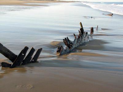
More than 3,500 vessels are estimated to have wrecked off the Massachusetts coast. Natural movement of sand and sediment and man-made alterations of the seafloor can uncover and disturb these sites and expose ancient timbers and other artifacts. Many of these archaeological discoveries are made by people just walking along the shore. To be prepared should you stumble upon a wreck remnant on the beach, visit these web pages:
- SHIPS—The Shoreline Heritage Identification Partnerships Strategy - This Board of Underwater Archaeological Resources (BUAR) web page describes what to do in the event you discover a ship's timber or other archaeological object on the beach.
- CZ-Tip - Uncovering Maritime History at the Shore - This CZ-Tip explains the importance of underwater archeological finds, who is responsible for protecting them, and how to safeguard these potential treasures.
- A Tale of Two Shipwrecks (PDF, 690 KB) - From Sea History magazine (Autumn 2008), this article explores the mystery of a shipwreck found on an outer Cape Cod beach, as well as one found the same year on the Oregon shores.