
Overview
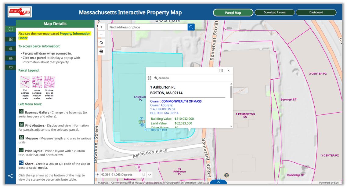
The ALL NEW Massachusetts Interactive Property Map, developed in ArcGIS Experience Builder by MassGIS, enables developers, banks, realtors, businesses, and homeowners to view seamless property information across the Commonwealth. This new version is optimized for desktop, tablet and mobile devices.
One of a handful of such state-sponsored tools in the country, the ongoing effort is the product of MassGIS working with community assessors, their mapping consultants, and other stakeholders. 1
Feature Highlights
Below are some of the features of the application in the Parcel Map tab:
Assessment Data
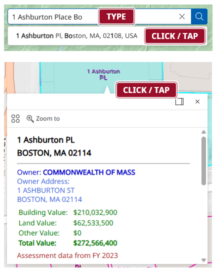
- Type an address or a place. The type-ahead feature will populate results. Click/tap on your desired result to zoom to that location. The little yellow marker is merely the address finder result location. Then you must:
- Click/tap on the parcel to view property information such as land valuation, owner, and use description. 2, 3
Click the up arrow at the bottom of the map to view the statewide parcel attribute table. You can display just the selected parcels and filter by map extent to list only the records for parcels appearing in your current map view, and you can select records in the table and choose to zoom or pan to them and open their popups.

Switch Background
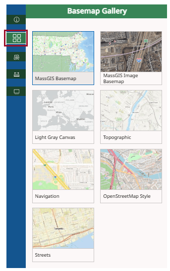
- Click the “Basemap Gallery” button to change the background map.
- Aerial photography is available from the most recent flight year, as are other maps.
Find Abutters
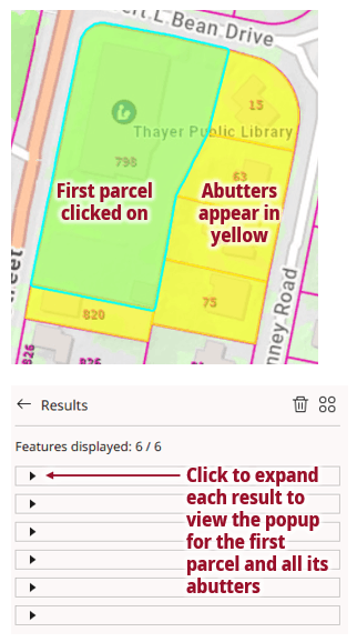
- Click the “Find Abutters” button in the menu panel to display and view information for parcels adjacent to the selected parcel. (This tool is not available on mobile devices)
- Click on a parcel to select it (it will have a light blue shading), then click the 'Apply' button. The selected parcel and its adjacent parcels will be highlighted in yellow.
- Click the little triangle on each of the results to expand the popup for each parcel.
Distance Measurements
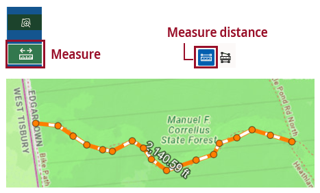
- Click on the "Measure" button in the menu panel and choose the "Measure distance" tool in the Measure pane.
- Click on the map to start, click to change direction along the line, and double-click to finish. The distance appears along the line.
- Click the Unit dropdown at any time to change units (miles, feet, kilometers, etc.).
Area Measurements
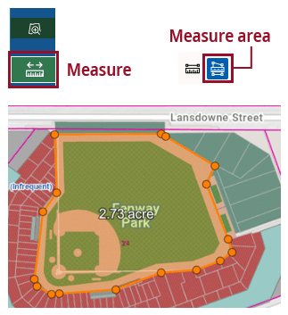
- Click on the "Measure" button in the left menu panel and choose the "Measure area" tool in the Measure pane.
- Click your starting point, click around the perimeter, and double-click to complete. The area appears in the center of the shape.
- Click the Unit dropdown at any time to change units (square miles, square feet, acres, etc.). 4
Print, Share
- Click the “Print Layout” button to save the map as a PDF file or image (in JPG or PNG formats). You can enter a title and credits. Layouts will not display open popups on the map. To print a map with the popup, make a screenshot or click the "Print Screen" button on the left side of the map to open your browser's Print Preview dialog. Tip: First minimize the left sidebar panel by clicking the opened green button, otherwise the panel will appear in the preview. (Not available on mobile devices)
- Click the Share button to create a URL, QR code and embed code of the app or post to social media.

Coordinates
- The Coordinates widget in the lower left of the map displays the position of your mouse pointer as you move it around the map in decimal degrees latitude/longitude coordinates (WGS84 Web Mercator).
- Click the cursor button to the left of the coordinates to enable the option to click on the map to get the coordinates. Click the Copy button to copy those coordinates to the clipboard. Click the down arrow to choose a different coordinate system (NAD1983 Mass. State Plane Mainland Meters or Feet). Note that when switching to NAD1983 meters or feet, you will not see the coordinates change as you move the mouse around the map.
Download Parcels Tab

Download standardized property tax parcel data in shapefile and file geodatabase formats by municipality from MassGIS. To download: Click on any city or town on the map and the popup will contain links to its parcel data in each format (in .zip files). (Available only on desktop devices)
Dashboard Tab

Displays status information of MassGIS' parcel data holdings by city and town in a map, table and pie chart. (Available only on desktop devices)
Non-Map Property Information
The assessment data are also available in accessible format in the Property Information Finder, which meets 508 Compliance Requirements and allows you to search for property assessment data by address only. It does not include a map or the other features provided by the Interactive Property Map.
End Notes
1. Parcel Mapping
For full details about the statewide parcel mapping project and to download these free data for use in GIS software, see:
- MassGIS Standard for Digital Parcels and Related Data Sets
- Standardized Assessors' Parcels data layer (AKA Property Tax Parcels)
2. Property Assessments
MassGIS displays the most recent annual updates of property information for each community delivered to MassGIS. This, however, depends on how frequently the municipalities or their consultants submit standardized assessor maps and assessor information. Many communities submit parcel data annually, but not all do, so some of the assessor data may not be entirely current. The fiscal year of the information is displayed in a pop-up when you click a particular parcel.
The most up-to-date assessing information is available directly from each municipality, typically through the assessing department. Many municipal web sites have an online property lookup feature, usually on the assessor's page.
3. Data Sources
The Massachusetts Interactive Property Map displays property boundaries from assessor parcel maps for all 351 cities and towns in the Commonwealth. Each parcel is linked to selected descriptive information from the municipalities' assessor databases. Data are provided to MassGIS from each city or town or their GIS mapping contractors.
All data are served from MassGIS' ArcGIS Online organizational account. Boundaries (magenta lines) on the map are stored as a tile cache for fast display. Popup information is stored in a hosted feature layer.
4. Property Boundaries
Assessor’s parcel mapping is a representation of property boundaries, not an authoritative source.
- The authoritative record of property boundaries is recorded at the registries of deeds.
- A legally authoritative map of property boundaries can only be produced by a professional land surveyor.
Contact
Online
Address
| Last updated: | August 13, 2026 |
|---|